Showing 6754 items matching " rivers"
-
 Greensborough Historical Society
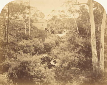
Photograph (copy), Willis's Mill, 1855c
Photograph of ruins of early flour mill on Plenty River.http://www.mintinc.com.au/pdf/carome_mill_arch_report.pdf Detailed report on same.A photocopy of a photograph of Willis's Flour Mill located on the Plenty River behind Carome Station Mernda.Nilplenty river, flour mill, mernda, yan yean reservoir, riparian rights, 1840, fred kruger, williss mill -
 Port Fairy Historical Society Museum and Archives
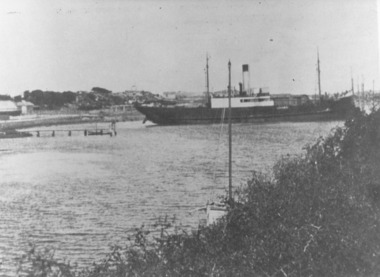
Photograph
This shows the S.S.Wannon turning in the specially widened part of the river called the "turning basin" before slipping into her berth at the Belfast and Koroit Steam Navigation Company wharfBlack and white photograph of SS Wannon turning in the Moyne Rivership, boat, sea, moyne river, belfast and koroit steam navigation company, turning basin -
 Greensborough Historical Society
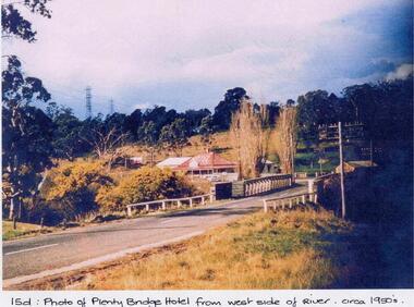
Photograph - Digital image, Plenty Bridge Hotel from west side of river, 1950s
Colour photograph of Plenty Bridge Hotel (Lower Plenty) from west side of river. Also shows bluestone bridge over Plenty River at Lower Plenty.Digital copy of colour photograph.On front of photograph: "15d Plenty Bridge Hotel from west side of river circa 1950s"lower plenty, plenty bridge hotel -
 Tatura Irrigation & Wartime Camps Museum
Book, The River Murray, 1990
Written to record history of River Murray from aboriginal times, early settlers, riverboats, maps, irrigation, agriculture.Map of Murray River and districts on front cover. 4 river scenes in square boxes. Gold disc, paddle steamer, names of 3 states. Early scenes n back cover. 1 present day.irrigation, books, reference, rural, industry -
 Marysville & District Historical Society
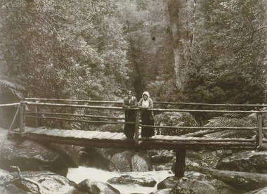
Photograph (item) - Black and white photograph, Unknown
A black and white photograph of two ladies standing on a timber bridge crossing the Taggerty River.A black and white photograph of two ladies standing on a timber bridge crossing the Taggerty River.taggerty river, timber bridge -
![Bend of the River Watt / [by] Nicholas Caire, circa 1876](/media/collectors/550653872162f11fb04854aa/items/577b52c2d0cdd10948cc9307/item-media/577b5328d0cdd10948ccc8b6/item-fit-380x285.jpg) Kew Historical Society Inc
Kew Historical Society IncPhotograph, Anglo-Australasian Photographic Company, Bend of the River Watt, c.1876
Nicholas Caire was born on Guernsey in the Channel Islands in 1837. He arrived in Adelaide with his parents in about 1860. In 1867, following photographic journeys in Gippsland, he opened a studio in Adelaide. From 1870 to 1876 he lived and worked in Talbot in Central Victoria. In 1876 he purchased T. F. Chuck's studios in the Royal Arcade Melbourne. In 1885, following the introduction of dry plate photography, he began a series of landscape series, which were commercially successful. As a photographer, he travelled extensively through Victoria, photographing places few of his contemporaries had previously seen. He died in 1918. Reference: Jack Cato, 'Caire, Nicholas John (1837–1918)', Australian Dictionary of Biography.An original, rare photograph from the series 'Views of Victoria: General Series' by the photographer, Nicholas Caire (1837-1918). The series of 60 photographs that comprise the series was issued c. 1876 and reinforced a neo-Romantic view of the Australian landscape to which a growing nationalist movement would respond. Nicholas Caire was active as a photographer in Australia from 1858 until his death in 1918. His vision of the Australian bush and pioneer life had a counterpart in the works of Henry Lawson and other nationalist poets, authors and painters.Views of Victoria (General Series) No.26 / 'Bend of the River Watt' / Albumen silver photograph mounted on boardOn Reverse: 'The present illustration represents a scene on the River Watt, and is situated in the valley between Mount Juliet and Mount Monda. The immediate neighbourhood abounds with scenery of the wildest and most romantic character. The River here is as clear as crystal, owing, no doubt, to its bed being composed of rock and pebbles. The banks on either side are studded with foliage so dense as to render access to the neighbourhood almost impracticable.’nicholas caire (1837-1918), australia - landscape photography -
 Charlton Golden Grains Museum Inc
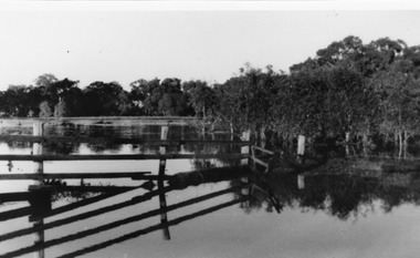
Photograph, B/W photograph of Flooded Billabong Cadrows Dairy in the bend of the Avoca River
Flooded Billabong Cadrows Dairy in the bend of the Avoca River, Charlton, VictoriaB/W photograph of Flooded Billabong Cadrows Dairy in the bend of the Avoca River, Charlton, Victoriaflood, charlton, avoca river, cadgow -
![Article, Greensborough RSL, Memorabilia: Did You Know [Article on water powered flour mills], 1842o](/media/collectors/4f729f5697f83e03086015b8/items/5091b7fc2162ef017426bfd2/item-media/509a25b52162ef0d908e9725/item-fit-380x285.jpg) Greensborough Historical Society
Greensborough Historical SocietyArticle, Greensborough RSL, Memorabilia: Did You Know [Article on water powered flour mills], 1842o
Contains a brief history of the various flour mills that existed on the Plenty River upstream from Greensborough and some others in the district.Contains some hard to find information on district flour mills and their fate.A one page article on Plenty River flour mills written by Jim Allen.Niljanefield mill, george coulstock, john brock, peter hurlestone, carome mill, thomas mill, plenty river, yan yean reservoir, boadles mill, marsh farm, diamond creek -
 Lakes Entrance Historical Society
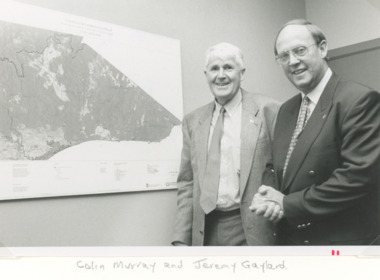
Photograph, Lakes Post Newspaper, East Gippsland Catchment and Land Protection, Lakes Entrance Victoria, 1/12/1995 12:00:00 AM
... Rivers ...Black and white photograph of Colin Murray and Jeremy Gaylard at the East Gippsland Catchment and Land Protection meeting during inspection of the area of Lakes Entrance Victoria. Also a colour photograph of upper reaches of the Nicholson River during a dry season environment, wetlands, rivers, conservation -
 Marysville & District Historical Society
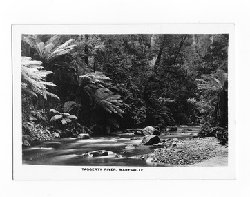
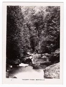
Photograph (item) - Black and white photograph, Rose Stereograph Company, Taggerty River, Marysville, 1913-1967
A black and white photograph of the Taggerty River in Marysville in Victoria.A black and white photograph of the Taggerty River in Marysville in Victoria. The photograph was also used to produce the Rose Series postcard P. 2337.taggerty river, marysville, victoria, p. 2337, rose series postcard, postcard, souvenir -
 Lakes Entrance Historical Society
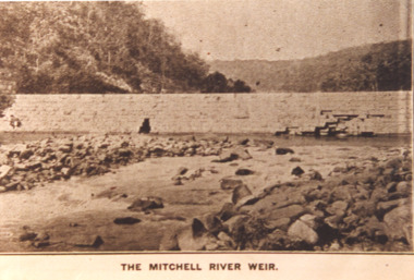
Photograph - Mitchell River Weir, Glenaladale Victoria, 1900 c
The Mitchell River Weir was commenced in 1900 work continued until almost completed, Foundation stone laid in March 1893 but the extensive flood damage in December 1893 ended the high hopes of the planners.Sepia toned photograph of weir on the Mitchell River at Glenaladale Victoriatopography, waterways, weir's -
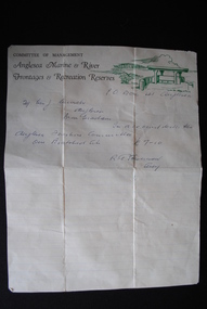 Anglesea and District Historical Society
Letter, R.G. Stevenson (Secretary), Pre-decimalisation
Letter written to Mrs J. Murch by the Secretary (R.G Stevenson) of the Committee of Management of Anglesea Marine & River Frontages & Recreation Reserves which records payment receipt of 7.10 pounds for a boatshed site. COMMITTEE OF MANAGEMENT / Anglesea Marine & River Frontages & Recreation Reserves. Plus drawing in green of Loveridge Lookout.anglesea marine & river frontages & recreation reserves, j. murch -
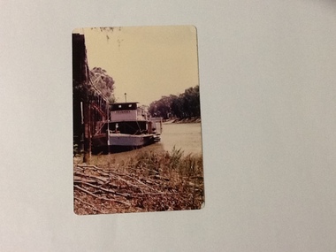 Port of Echuca
Colour Photograph, 1977
P. S. PEVENSEY: Dimensions: 111ft 5 ins X 23 ft X 6ft 8 ins. Tonnage:130 tons Built: 1910 at Moama, N. S. W. References : Book: Murray river Paddle Steamers by D. Wardle Permewan , Wright & Co. : pp. 72, 129, 157 The P. S. PEVENSEY holds historical and social significance for the Port of Echuca, being the cornerstone of their paddlesteamer fleet. The PEVENSEY was renamed for the TV series All the Rivers Run, to P. S. Philadelphia , playing a staring role in the program, which has resulted in the PEVENSEY becoming a tourist attraction and has increased tourism to the Port of Echuca. The PEVENSEY was originally designed for use on the Murrumbidgee river, named after Pevensey station on that river. It was then owned by Permewan Wright & co operating out of Echuca for many years. She returned to Echuca in 1975 to begin another life as part of the Port of Echuca tourism operation.Colour photograph of the P. S. Pevensey, moored at the Port of Echuca wharf . Photograph taken looking north along the river, from the river bank.On the front:PEVENSEY on the wheelhouse of the boat. Printed on reverse: This paper manufactured by Kodak: Print made by Kodak: Dec.77-Mriverboats, p.s.pevensey, echuca, port of, paddle steamers, echuca wharf -
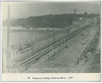 Chelsea & District Historical Society Inc
Photograph - Patterson River, Temporary and Old Bridge, c 1927
The first bridge over the river was built in the early 1880's, prior to this it was a pontoon bridge. In 1927 the construction of a concrete bridge was undertaken.Black and white photo of the old wooden road bridge (Point Nepean / Nepean Highway), and a temporary bridge over Patterson River, Carrum near the mouth of the river. Cars using the old bridge. Rowing boats on shore. Temporary and old bridge, Carrumpatterson river, road bridge, rail bridge, chelsea, transport, patterson river bridge, carrum bridge, temporary bridge, cars -
Glenelg Shire Council Cultural Collection
Photograph - Photograph - Killara Bridge over Glenelg River, c. 1963
Sourced from Casterton Town Hall (former Shire of Glenelg)Black and white photo. View of Killara Bridge over Glenelg RiverFront: Black stamp - 003635 Back: 'View of Killara Bridge over Glenelg River' - handwritten in pencil. Blue biro line arrowed both ends, drawn across width of photo. 3" in blue biro written above line -
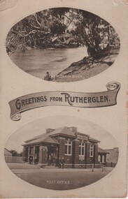 Rutherglen Historical Society
Postcard - Image, Greetings from Rutherglen, c1890
... rivers ...Post card featuring two black and white photographs with a banner saying "Greetings from Rutherglen" between the photos. The top one is captioned "The Murray River", the bottom one captioned "Post Office" rutherglen, murray river, rutherglen post office, buildings, rivers -
 Wodonga & District Historical Society Inc
Album - Ringer's River by Des Martin - Plate 26 - Erin learns of Police party arriving
Erin O'Hara is buying material at Rosenthal's store in Overton when she learns that a special police party has come off the afternoon train to trap Daylight and Keiran with the mob of cattle they are bringing across the river that day. Margaret Wehner as Miss. Rosenthal.The album and images are significant because they document literature written by a prominent member of the Wodonga community. The presentation of this precis was supported by several significant district families and individuals.Ringer's River Album Coloured photo Plate 26des martin, many a mile, ringer's river, northeast victoria stories -
 Stawell Historical Society Inc
Photograph, Indigenous or First Nation Person at Carrs Plains with Traditional weapons. Demonstration of war weapons by Jardwadjali man, Jacky Cocooquine
Indigenous or First Nation Person beside a large Red River Gum and next to a river (Richardson River) with aboriginal tools. Photo taken at Carrs Plains. Holford Wettenhall, took over as Protector when William Dennis left the Station. Observed during this time indigenous people mainly hunted possum. The last surviving indigenous people at Carrs Plains were moved to Lake Condah and Ebeneezer in 1870. Black and white photograph of a large River Red Gum, with a man standing holding a boomerang, killing stick and shield. Copyright Museum of Victoriastawell aboriginal portrait -
 Orbost & District Historical Society
black and white photograph, Howard D. Bulmer, first half 20th century
A new bridge over the Snowy River at Orbost was opened for traffic on June 20th 1922. It was intended as a road and rail bridge, and was again partly washed away by flood waters in 1934. After the end of the first World War the Victorian Railways considered an extension of the railhead across the river at Orbost, and in 1922 a new timber and steel girder structure, a joint Country Roads Board — Victorian Railways venture, was built and completed at a cost of £41,000 (the steel girders came from the Flinders Street viaduct reconstruction). Subsequently it was decided decided not to take the railway across the river, and the bridge was only used by road traffic. This is a pictorial record of an early bridge over the Snowy River at Orbost.A black / white postcard photograph of a bridge across a shallow river with men on horseback underneath.snowy-river-bridge -
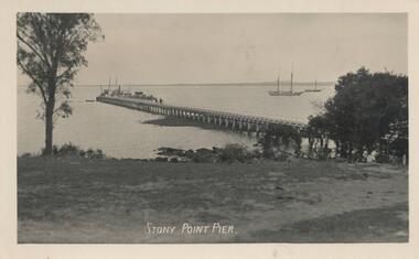 Phillip Island and District Historical Society Inc.
Photograph - Post Card, Stoney Point
Three from a collection of Postcards donated by Mary Karney450-23: Postcard of the Stony Point Pier on Mornington Peninsula. Ferries went from Cowes to Stony Point often via French Island. 450-24: Postcard of the Breakers at Kilcunda. 450-25: Postcard of the Powlett River near the mouth.Stony Point Pier Breakers Kilcunda 182 Powlett River near the mouth 86stony point pier, mary karney, kilcunda, powlett river -
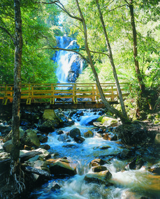 Marysville & District Historical Society
Photograph (item) - Colour photograph, Pre 2009
A colour photograph of the wooden bridge over the Steavenson River at the base of the Steavenson Falls in Marysville in Victoria.A colour photograph of the wooden bridge over the Steavenson River at the base of the Steavenson Falls in Marysville in Victoria. This bridge was destroyed in the 2009 Black Saturday bushfires. The Steavenson Falls are named after the Victorian Assistant Commissioner of Roads and Bridges, John Steavenson who arrived in Victoria in the early 1860s.steavenson river, steavenson falls, marysville, victoria, waterfalls, john steavenson, 2009 black saturday bushfires -
Port Fairy Historical Society Museum and Archives
Photograph
aerial view over Port Fairy looking across the river at the railway line and butter factoryBlack and white aerial photograph of Port Fairy looking across the Moyne river and railway stationaerial, railway, river, town -
 Stawell Historical Society Inc
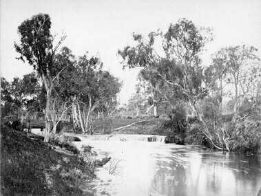
Photograph, Wimmera Falls in Glenorchy 1866
Wimmera Falls Glenorchy. Part of a collection of Photographs by Mr. O.G. Armstrong as commissioned by the Shire of Stawell for the Inter-colonial and Paris Exhibition in Melbourne in 1866. The fact that there was ever a natural waterfall in the Wimmer River would probably be a surprise to anyone who has known the river at all. There are many man-made weirs across it in several places today, one of them at Glenorchy is thought to hide the original falls. A Stawell Paper dated 21st August 1888, refers to them being a mile below the Township. View of river amongst gum trees with shallow falls at centre of photograph.stawell -
 Wodonga & District Historical Society Inc
Album - Ringer's River by Des Martin - Plate 9 - O'Day meets Elaine and Ruby
Resting in the shade above the river after he has brought his cattle over it, O'Day is disturbed by voices, and rolls over to discover Montieth's daughter Elaine, and her aboriginal companion, Ruby, enjoying themselves in the river. This first encounter with Elaine makes an impression on the young manager that is to last throughout his lifetime.The album and images are significant because they document literature written by a prominent member of the Wodonga community. The presentation of this precis was supported by several significant district families and individuals.Ringer's River Album Coloured photo Plate 9 Resting in the shade above the river after he has brought his cattle over it, O'Day is disturbed by voices, and rolls over to discover Montieth's daughter Elaine, and her aboriginal companion, Ruby, enjoying themselves in the river. This first encounter with Elaine makes an impression on the young manager that is to last throughout his lifetime. Geni Dynon as Ruby and Joan Lehmann as Elaine.des martin, many a mile, ringer's river, northeast victoria stories -
 Kiewa Valley Historical Society
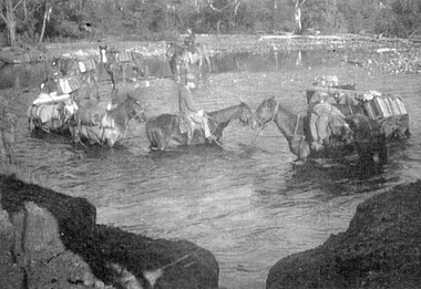
Photos: black and white - Working Horses
Photo No. 9 Horses Crossing River - Packing in supplies for early workers on the Kiewa Hydro Scheme. There were no roads in the early days of the Scheme. Horses from the Kiewa Valley were used to transport goods prior to roads and vehicles being available1. Horses crossing river - 2 copies 2. Pack horses 3. Rider with pack horse -x2 and See (KVHS 1396) 4. Cattle entering river 5. Horses on High Plains x2 6. color - Horses in River 7. Pack horses and carts 8. 4 Cattlemen with dog in foreground 9. Color - Horses crossing river 10.Horses and tents - Harry Trimble x2working horses, horses from the kiewa valley -
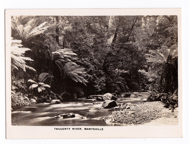
 Marysville & District Historical Society
Photograph (item) - Black and white photograph, Rose Stereograph Company, Taggerty River, Marysville, 1913-1967
An early black and white photograph of the Taggerty River in Marysville, Victoria.An early black and white photograph of the Taggerty River in Marysville, Victoria. The photograph was published by the Rose Stereograph Company ans was used to produce the Rose Series postcard P. 2338.marysville, victoria, photograph, taggerty river, p. 2338, rose stereograph company, souvenir, rose series postcard -
 Marysville & District Historical Society
Photograph (item) - Black and white photograph, Rose Stereograph Company, Taggerty River, Marysville, 1913-1967
An early black and white photograph of the Taggerty River in Marysville, Victoria.An early black and white photograph of the Taggerty River in Marysville, Victoria. The photograph was also used to produce the Rose Series postcard P. 2308.marysville, victoria, photograph, taggerty river, p. 2308, rose stereograph company, souvenir, rose series postcard -
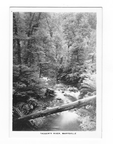
 Marysville & District Historical Society
Photograph (item) - Black and white photograph, Rose Stereograph Company, Taggerty River, Marysville, 1913-1967
An early black and white photograph of the Taggerty River in Marysville, Victoria. An early black and white photograph of the Taggerty River in Marysville, Victoria. The photograph was published by the Rose Stereograph Company ans was used to produce the Rose Series postcard P. 2338.marysville, victoria, photograph, taggerty river, p. 2338, rose stereograph company, souvenir, rose series postcard -
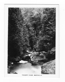
 Marysville & District Historical Society
Photograph (item) - Black and white photograph, Rose Stereograph Company, Taggerty River, Marysville, 1913-1967
An early black and white photograph of the Taggerty River in Marysville, Victoria.An early black and white photograph of the Taggerty River in Marysville, Victoria. The photograph was also used to produce the Rose Series postcard P. 2308.marysville, victoria, photograph, taggerty river, p. 2308, rose stereograph company, souvenir, rose series postcard -
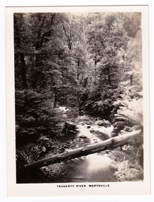
 Marysville & District Historical Society
Photograph (item) - Black and white photograph, Rose Stereograph Company, Taggerty River, Marysville, 1913-1967
An early black and white photograph of the Taggerty River in Marysville, Victoria.An early black and white photograph of the Taggerty River in Marysville, Victoria. The photograph was also used to produce the Rose Series postcard P. 2337.marysville, victoria, photograph, taggerty river, p. 2337, rose series postcard, souvenir, rose stereograph company