Showing 427 items
matching topography
-
 Lakes Entrance Historical Society
Book, Land Conservation Council Victoria South Gippsland Area District 2, 1980
Report describing and assessing the natural resources of the public land in the South Gippsland (Victoria) Study Area 2, comprising the Latrobe Valley, Strzelecki Range, South Gippsland coastal plains and all of Wilson's Promontory. History, Geology, floRuth Clarkgippsland, topography, natural history, vegetation -
 Lakes Entrance Historical Society
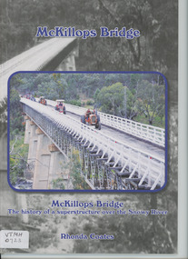
Book, Anne Bell, McKillops Bridge by Rhonda Coates
history of McKillops Bridge over the Snowy River Soft cover book by Rhonda Coates detailing the history McKillops Bridge over the Snowy River bridges, civil engineering, road construction and maintenance, topography -
 Lakes Entrance Historical Society
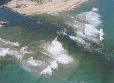
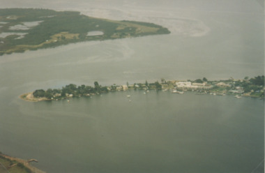
Photograph - Boat Harbour, Gippsland Ports, dredge April Hamer Lakes Entrance, 2006
Colour aerial photograph of the Entrance from Bass Strait to the Gippsland Lakes showing rock entrance groynes, surf on beach, dredge April Hamer working in the channel Lakes Entrance Victoria. Also another copy size 15 x 19.5 cmwaterways, topography, beaches, ocean -
 Lakes Entrance Historical Society
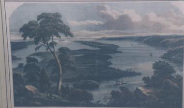
Photograph - Jemmys Point Lakes Entrance, 1880 c
Colour photograph print of early painting of view from Jemmys Point towards Metung showing paddle steamer and Aboriginals in bottom left hand corner Rigby Fraser and Flannagan Islands centre of painting, The Barrier on the left Nungurner Hills on right Gippsland LakesEntrance to The Gippsland Lakesaerial photograph, township, topography, jemmys point lakes entrance -
 Lakes Entrance Historical Society
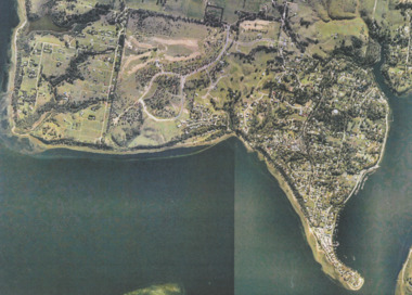
Photograph - Metung, Gippsland Ports, 2006 c
Colour aerial photograph showing Shaving Point at Metung including Chinamans Creek at the right housing subdivisions of Kingscove Estate Tambo Bluff Estate and Lake King on Gippsland Lakes Victoriaaerial photograph, topography, waterways, metung -
 Lakes Entrance Historical Society
Photograph - Metung, 1995 c
Colour aerial photograph of Shaving Point Gippsland Lakes with Mosquito Point bottom left hand corner Boole Poole on opposite shore Metung Victoriaaerial photograph, waterways, topography, metung -
 Lakes Entrance Historical Society
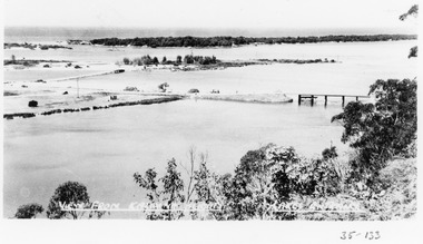
Photograph - View from Kalimna Heights, 1945c
Black and white photograph of view from Kalimna Heights, showing part of the North Arm concrete bridge, Bullock Island and western side of entrance. Truck parked on approach to bridge. Lakes Entrance Victoriatopography, bridges, waterways, transport -
 Lakes Entrance Historical Society
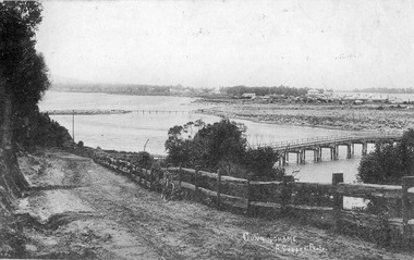
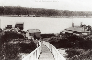
Postcard - Cunninghame township, Lakes Entrance Victoria c1905, 1905c
Also Black and white copy 12.5x20.5 Good condition P01146.1Black and white postcard of Cunninghame township, mud flats, North Arm Bridge, wooden bridge to mud island in North Arm, post and rail fence, beside main road. Road appears to have a sand surface. Bicycle leaning against fence. Lakes Entrance Victoriabridges, fences, topography, roads and streets -
 Lakes Entrance Historical Society
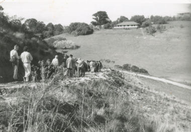
Photograph - North Arm Lakes Entrance, Lakes Post Newspaper, Frenchman's Gully, Lakes Entrance Victoria, 1996 c
Black and white photograph of Frenchman's Gully, track to Wyanga Winery showing group of people walking towards designated pickup spot for Winery bus Lakes Entrance Victoriaaerial photograph, topography, settlement, lakes entrance -
 Lakes Entrance Historical Society
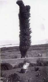
Photograph - The tree on Merrangbaur Hill, 1920c
Black and white photograph of The Tree on Merrangbaur Hill. This dead iron bark tree covered with vine, was for many years a landmark for vessels at sea. View of sand hummocks and Cunninghame Arm in background. Lady seated on deckchair in Merrangbaur House garden, Lakes Entrance Victoria.guesthouses, topography, coast, local history -
 Lakes Entrance Historical Society
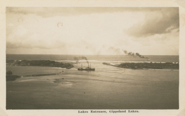
Postcard - Steamers on Gippsland Lakes, 1930 c
Black and white postcard showing a steamer leaving the Entrance channel and turning into Cunninghame Arm, a second steamer at sea beyond the Western Pier Lakes Entrance VictoriaLakes Entrance Gippsland Lakesships and shipping, transport, gippsland lakes, topography -
 Lakes Entrance Historical Society
Photograph - New Works precinct Lakes Entrance Victoria 2010, M Holding, 2010 c
Colour photograph of cottages and jetties at New Works precinct Lakes Entrance Victoriajetties, topography, ships and shipping, historic houses -
 Lakes Entrance Historical Society
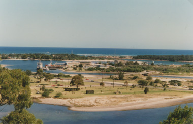
Photograph - Apex Park Lakes Entrance Victoria, M Holding, 1985 c
The town section of North Arm previously known as The Backwater Road Colour photograph taken from Kalimna Heights showing outer barrier and entrance channel. Road and new bridge to Bullock Island Apex Park beside North Arm in foreground has old playground equipment with timber fort and hillock with underground tunnel Lakes Entrance Victoria topography, waterways, parks, bullock island -
 Lakes Entrance Historical Society
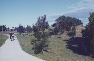
Photograph - Esplanade Lakes Entrance Victoria, Lakes Entrance Tidy Town, 1995 c
Colour photograph showing two children and an adult riding bicycles on pathway between south end of North Arm bridge and Bullock Island road. Middle distance left turn into Marine Parade foreground now site of skate park. In distance palm trees at entry to Esplanade Lakes Entrance Victoriarecreation, topography, roads and streets, parks -
 Lakes Entrance Historical Society
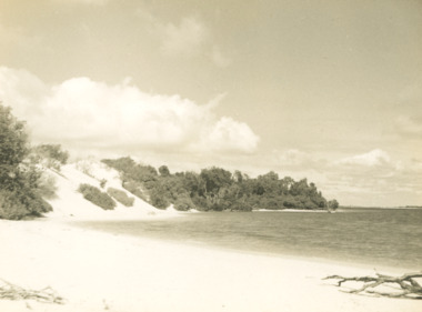
Photograph - Sand hummocks Lakes Entrance Victoria c1952, L Carpenter, 1952 c
Black and white photograph of an area of the sand hummocks known locally as Hill 60 Sandy beach and lake in foreground Lakes Entrance Victoria. Also two black and white photographs taken from sand hummocks looking west down Cunninghame Arm c1952 township, topography, gippsland lakes, sand dunes -
 Lakes Entrance Historical Society
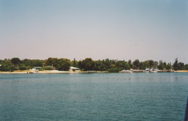
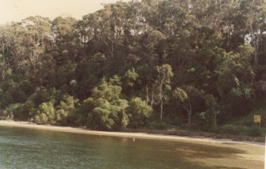
Photograph, M Fish, Kalimna Waterways Gippsland Lakes, 1980 c
taken from Kalimna jetty of Northern Shore of Kalimna Cove showing dense vegetation above rock wall and sandy shore Kalimna Victoria. Second colour photograph shows continuation of scene westward along Reeves Channel Fraser Island visible to South number 04200.1 size 10 x 15 cmColour photograph taken from Kalimna jetty of Northern Shore of Kalimna Cove showing dense vegetation above rock wall and sandy shore Kalimna Victoria. Second colour photograph shows continuation of scene westward along Reeves Channel Fraser Island visible to South number 04200.1 size 10 x 15 cmbridges, waterways, gippsland lakes, topography -
 Lakes Entrance Historical Society
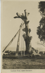
Postcard, H D Bulmer, Historic Lookout tree Jemmys Point Lakes Entrance, 1925 c
Jemmys Point showing an old dead grey box tree trunk many limbs lying on ground near base trunk stabilized by two long poles straight ladder from ground to fork at top Lakes Entrance Victoria. This tree eventually fell down in 2024. East Gippsland shire have placed a garden bed around it.Black and white postcard of Lookout on Jemmys Point showing an old dead grey box tree trunk many limbs lying on ground near base trunk stabilized by two long poles straight ladder from ground to fork at top Lakes Entrance VictoriaLookout Tree Lakes Entrancejetties, waterways, jemmys point lakes entrance, topography -
 Lakes Entrance Historical Society
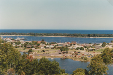
Photograph - Bullock Island Lakes Entrance, Holding M, 2000 c
photographs showing view of town from across North Arm from western boat ramp east to Orme Street continued from 04216 number 04216.1 and 04216.2 size 10 x 15 cm|. Colour photograph of town from Kalimna Heights showing Hill 60 on Hummocks taken 1975 c printed from slide number 04216.3Colour photograph of western end of town taken from Kalimna Heights showing cars parked near western boat ramp and North Arm, hummocks and Bass Strait in distance, Lakes Entrance Victorialookouts, topography, buildings, islands -
 Lakes Entrance Historical Society
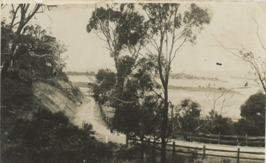
Postcard - Princes Highway around Jemmy's Point
Princes Highway around Jemmy's Point . Unsealed road and post and rail fence. Bullock Island and the entrance in the distance c1925Black and white photograph of Princes Highway around Jemmy's Point . Unsealed road and post and rail fence. Bullock Island and the entrance in the distance waterways, topography, islands, roads and streets -
 Lakes Entrance Historical Society
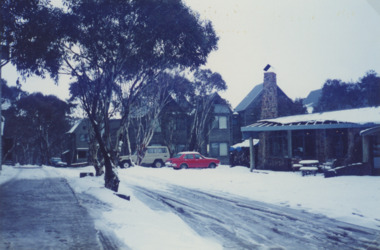
Photograph - Dinner Plain, Victoria, June 1996
Colour photo of cars parked in the snow at Dinner Plain, Victoria 1996. Plus color photo of interior of the Lodge at Dinner Plain and another color photo of Dinner Plainsport, topography, snowfields, accommodation -
 Lakes Entrance Historical Society
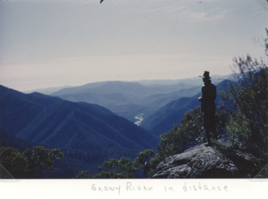
Photograph - Snowy River in the Alpine Country East Gippsland Victoria, Keith Scarce, 1979
Colour photograph showing glimpses of the Snowy River in the Alpine Country East Gippsland Victoriaparks, rivers, topography, mountains -
 Lakes Entrance Historical Society
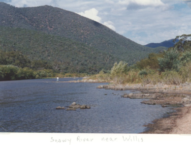
Photograph - Snowy River near Willis Victoria, M Holding, 1994 c
Colour photograph of the Snowy River in the alpine Country near Willis Victoriageology, topography, rivers, mountains -
 Lakes Entrance Historical Society
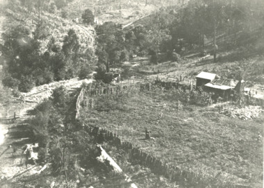
Photograph - gold mining town of Grant Victoria, 1900 c
Black and white photograph of a vegetable patch and flower garden beside a rustic dwelling surrounded by split paling fence near the gold mining town of Grant Victoriamines and mining, settlement, topography, gold -
 Lakes Entrance Historical Society
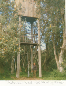
Photograph, Vera Bennett, Rotamah Island, Gippsland Lakes Victoria, 1/04/1989 12:00:00 AM
Colour photograph of the bird watching tower on Rotamah Island showing a timber hut and viewing platform supported on four timber poles accessed by steel ladders. Tower situated amongst coastal banksias Gippsland Lakes Victoria. Also another colour photograph of bird watching towerpeople, wildlife, topography, waterways -
 Lakes Entrance Historical Society
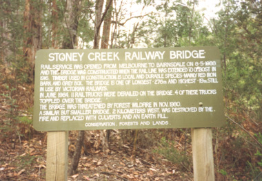
Photograph, Davies Judy, Stoney Creek Bridge Nowa Nowa Victoria, c1990
Colour photograpf of the sign erected by the Conservation, Forests and Lands Dept. at the Stoney Creek Bridge Nowa Nowa Victoria . Plus two other photos of the bridgebridges, forestry, tourism, topography -
 Lakes Entrance Historical Society
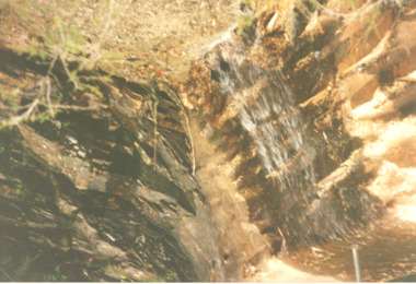
Photograph, Judy Davies, Cossticks Weir East Gippsland Victoria, 1990 c
Colour photograph of water spilling over the rock wall at Cossticks Weir East Gippsland Victoria. Also a colour photograph of waterway adjacent to Cossticks Weir East Gippslandbridges, waterways, weir's, topography -
 Lakes Entrance Historical Society
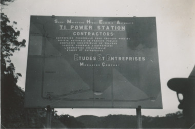
Photograph - Snowy Mountains Hydro Electric Scheme c1950, Jack Palmer, 1950 c
Black and white photograph taken at sign for Snowy Mountains Hydro Electric Scheme in Australian Alps. Also five other black and white photographs taken at Snowy Mountain project 6 x 8.5 cm government, civil engineering, topography, water resources -
 Department of Energy, Environment and Climate Action
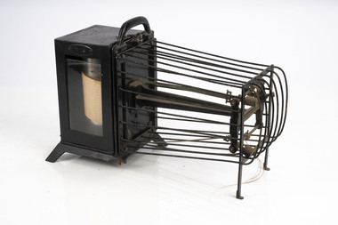
Thermo-hygrograph
Bushfire behaviour is influenced by many factors including temperature, relative humidity (RH), forest type, fuel quantity and fuel dryness, topography and even slope. Wind has a dominant effect on the Rate of Spread (ROS), as well as fire size, shape and direction. Temperature and relative humidity have major impacts on fuel dryness and therefore upon the availability of fuel for combustion. A thermo-hygrograph measures and records both temperature and humidity. It produces a continuous record by drawing ink traces on a paper chart held in revolving cylinder. Humidity is measured by shortening or lengthening of specially treated horse hair. Temperature is measured by means of a bi-metallic strip. This particular instrument is a seven day recorder. The instrument is driven by clockwork. Thermo-hygrographNegretti & Zambra -
 Lakes Entrance Historical Society
Photograph - New Works, 1910c
Also black and white copy 12.5 x 18 cm with smear of purple ink in top left hand corner, purchased from Helen ClothierTinted black and white photograph showing boardwalk from New Works Jetty over the sand dunes with small shed on jetty, small one room Boole Poole school on right of boardwalk and harbour master's house on right. Club Hotel on opposite foreshore and town on far right. Kalimna escarpment in background, at Lakes Entrance, Victoria.View of Cunninghame Victoriaboardwalk, waterways, ships and shipping, township, topography -
 Lakes Entrance Historical Society
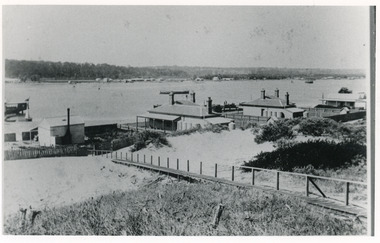
Photograph - Carpentertown, 1900c
Also four other black and white copies, one size 12 x 18 cm, two size 9 x 14 cm, and one size 10 x 15 cm, one of which was purchased from Helen ClothierBlack and white photograph showing buildings on dunes, and township of Lakes Entrance across lake, Cunninghame Arm. Buildings from left are school, harbour masters house, harbour engineer's house. Boardwalk in foreground. Kalimna Hill in background. Lakes Entrance Victoriawaterways, vegetation, topography, township, historic buildings