Showing 2471 items matching " township"
-
 Lakes Entrance Historical Society
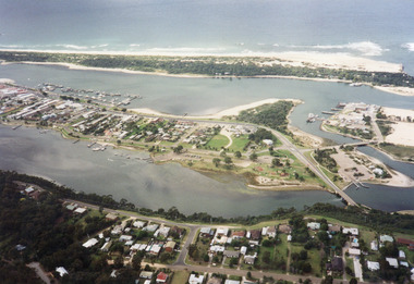
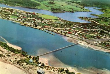
Photograph - Lakes Entrance, 1997c
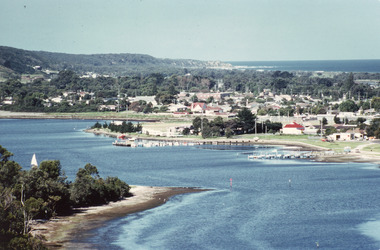
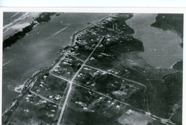
Colour print of aerial view looking south of western side of township. Shows housing on Kalimna Hill, North Arm, part of Bullock Island, Cunninghame Arm, the outer barrier and east pier of man made entrance. Lakes Entrance Victoriawaterways, township -
 Lakes Entrance Historical Society
Postcard, Bulmer H D, North Arm concrete bridge, Lakes Entrance Victoria c1950, 1950c
Township of Lakes Entrance Black and white photograph of view from Kalimna Heights, showing part of the North Arm concrete bridge, Bullock Island and western side of entrance. Truck parked on approach to bridge. Lakes Entrance Victoriatownship, jetties, islands, hotels -
 Kiewa Valley Historical Society
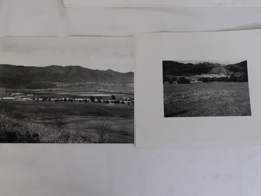
Photos x2 - Views of Mt Beauty
The State Electricity Commission of Victoria constructed the Mt Beauty township as part of their construction of the Kiewa Hydro Electric Scheme.Historic photos of the development of the Mt Beauty township2 B & W Photos. 1. Large - early photo of houses in front of pondage (taken for what is now the golf course). 2. Medium size - looking south towards Mt Beauty township with Mt Arthur in the backgroundOn back.1. Laurie Richards No. LH 1405 2. Laurie Richards No. Copy 518mt beauty township, laurie richards -
 Kiewa Valley Historical Society
Photograph - Mt Beauty Camp
The new State Electricity Commission construction camp at the head of the Kiewa Valley was for workmen on the second power station in the project expected to be the most modern and best equipped in Australia… In contrast to the early Kiewa days of horses and canvas tents, the new camp, with its modern amenities, compared favourably with any country town. Administration of the Kiewa Scheme was moved from Tawonga to Mount Beauty in 1946. The first house in Mount Beauty, in Hollonds Street, was occupied by the co-op store manager from November 1946. The new Mess Hall at Mt Beauty was opened with much ceremony in early November 1946. The houses up to Nelse street were erected from 1946 onward and then the township was extended beyond Nelse Street in 1950. The workmen's camp was enlarged in 1950 to the extent of providing accommodation for a total of 1,200.Shows early construction in the town of Mt. Beauty surrounded by hills and farmland, with a snow capped Mt Bogong in the background. Photo was taken in approximately 1950 during the early stages of construction of the Kiewa Hydro-electric SystemBlack and white photograph, mounted on corrugated cardboard. Photograph of Mt Beauty townshipHandwritten on back of photograph in blue pen - Permanent loan from Adrian Campan April 96 057-544043mt beauty camp, secv -
 Lakes Entrance Historical Society
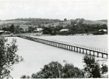
Postcard - Footbridge, 1937c
1 copy same|1 copy in poor condition- Mrs Helen Stokes|1 tinted copy. all same sizeBlack and white small format postcard of the footbridge over the Cunninghame Arm. It shows natural vegetation of the south shore in the foreground and residences and trees of the township and Myer Street ascending the hill in the background. Lakes Entrance Victoriawaterways, bridges, township -
 Lakes Entrance Historical Society
Photograph - Lakes Entrance, 1975c
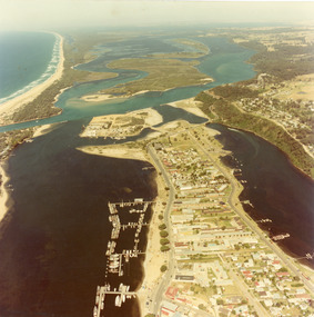
Copied from postcardColour photograph aerial view of the township, also showing North Arm, Cunninghame Arm, footbridge, and kiosk and Lifesaving Club on hummocks. Lakes Entrance Victoriawaterways, township, islands, jetties, aerial photograph -
 Bendigo Historical Society Inc.
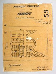
Map - PROPOSED TOWNSHIP PARISH OF CAMPASPE, 24th May 1875
Map: Proposed Township, Parish of Campaspe(This has been crossed out and 'Creek View' written above). Hand Draughted Parish plan Stapled to the backingmap, township, proposed township, campaspe, creek view -
 Lakes Entrance Historical Society
Book, Johnsonville Primary School, Johnsonville Primary School No 2761 Centenary 1886-1986, 1986
A detailed description of Township of Johnsonville Victoria. Giving the original details of the school and building surrounding with names of the original settlers. Many descriptive and captioned homesteads date range 1886-1986.schools, settlers, township, boats and boating -
 Bendigo Historical Society Inc.
Map - JACK FLYNN COLLECTION: HUNTLY, 12.03.1932
Map: Township of Huntly, Parish of Huntly , County of Bendigo. Parish plan. Western and South Riding Division on Main St. (Main Northern Highway) - written in ink below name of map.BY Authority H.J. Green. Photo-Lithographed at the Dept., of Lands and Survey, Melbourne. 12.3.32map, bendigo, township, huntly -
 Hume City Civic Collection
Photograph, c 1980s
The photograph although recently taken shows the original settled area in Sunbury, which included Goonawarra Vineyard and Macedon Street which was once the business centre of Sunbury township before the railway was established.A coloured photograph of Sunbury Township looking west from above Jacksons Creek and Goonawarra Winery. Macedon Street can be seen in the middle distance and Mt. Holden and Burke Hill are across the skyline.sunbury township, mt. holden, burke hill, francis, james goodall, barnier, john, jacksons creek, goonawarra winery, george evans collection -
 Halls Gap & Grampians Historical Society
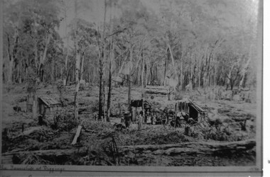
Photograph - B/W, C 1887
Photo depicts dwellings with people standing in front. A man is holding a horse loaded with bags. Huts in forground and background.the township at Diggings marked on frontmining, stoney creek -
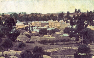 Clunes Museum
Photograph, CIRCA 1862
PHOTOGRAPH TAKEN BEFORE 1862 BECAUSE HALL BETWEEN CLUB HOTEL AND ES&A BANK WAS REMOVED IN 1862 TO BECOME CHURCH OF ENGLAND SUNDAY SCHOOL. CALEDONIAN BRIDGE IN FOREGROUND1. COLOURISED COPY OF PHOTOGRAPH OF CLUNES TOWNSHIP 2. B & W COPY OF PHOTOGRAPH OF CLUNES TOWNSHIP 3. B & W PHOTO OF CLUNES TOWNSHIP 4. COLOURED COPY OF PHOTOGRAPH OF CLUNES TOWNSHIP 5. COLOURED COPY OF PHOTOGRAPH OF CLUNES TOWNSHIPCLUNESlocal history, photography, photographs, clunes township -
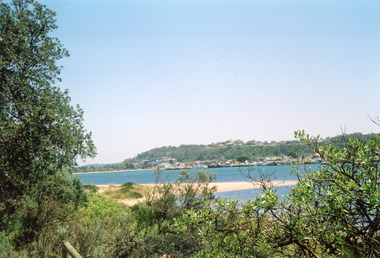 Lakes Entrance Historical Society
Photograph - Lakes Entrance, Davies, Judy, 2005c
Colour photograph of Jemmys Point, Kalimna Heights, and the Western end of the township, taken from the southern shore of Cunninghame Arm. Small sand spit and natural vegetation in foreground. Lakes Entrance Victoriajetties, waterways, topography, township -
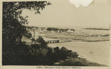 Lakes Entrance Historical Society
Postcard - First concrete bridge over North Arm Lakes Entrance Victoria, H D Bulmer, 1920 c
First concrete bridge over North Arm swamp land behind buildings on Esplanade low sand dunes on outer barrier Lakes Entrance VictoriaBlack and white postcard of township showing first concrete bridge over North Arm swamp land behind buildings on Esplanade low sand dunes on outer barrier Lakes Entrance VictoriaLakes Entrance from Princes Highwayislands, roads and streets, bridges, township -
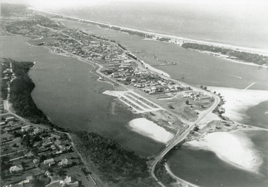 Lakes Entrance Historical Society
Photograph - Lakes Entrance, 1975c
Black and white photograph of an aerial view of township and Kalimna Heights, showing the North Arm bridge and boat ramp, sand buildup in the lake system, boat harbour, sand hummocks and beach as far as Red Bluff. Lakes Entrance Victoriaaerial photograph, topography, township -
 Lakes Entrance Historical Society
Photograph - Lakes Entrance, Fraser, Ian, 1985c
Colour photograph of the township, situated between Cunninghame Arm and North Arm. Boats moored in North Arm. Scrub covered hummocks of southern shore in background, taken from cleared vantage point on Kalimna Heights. Lakes Entrance Victoria boats and boating, waterways, township -
 Lakes Entrance Historical Society
Photograph - Lakes Entrance, 1980c
Colour photograph aerial view of township of Lakes Entrance, showing western end of town, Bullock Island, Cunninghame Arm and North Arm, man made entrance, and distant view of outer barrier, island and shoreline. Lakes Entrance Victoriawaterways, township, bridges -
 Lakes Entrance Historical Society
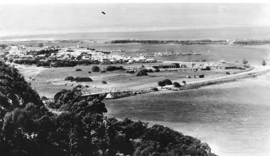
Photograph - Lakes Entrance, 1945 c
The Hulk of the Baang Yarnda on the North Arm foreshore. (Note in album)Black and white photograph showing view from Kalimna cliff overlooking North Arm and township, Cunninghame Arm and sand dunes out to Bass Strait. Hulk of old Baang Yarnda moored in North Arm, towed there in 1939 and left to rot. Thick vegetation in foreground. Lakes Entrance Victoria.township, waterways -
Kiewa Valley Historical Society
Papers - History of the Shire of Bright taking over Mt Beauty from the State Electricity Commission of Victoria
Mt Beauty township was built as a construction town by the SECV for their workers on the Kiewa Hydro Electric Scheme. In Oct. 1957 the Bright Shire agreed to take over the running of the town At the time it was thought that the section of 'North Mt Beauty ' would disappear. By 1961 and again in 1975, the Shire was still struggling with money for administration and maintenance of the town, including the 'sub-standard' homes in North Mt Beauty. The papers state the agreements made over the years from 1957 to 1975 in order to come to a new agreement.Correspondence between the SEC and the Bright Shire in 1975 confirms that the Shire was struggling to maintain the high standard with increased costs, set by the SEC during construction. "Mt Beauty provides less income to the Shire and offers a poor medium for the reception of grants and CRB assistance'. The papers state the agreements made over the years from 1957 to 1975 with negotiations for a new agreement. This still seems to be a problem in 2021 - a second rate town compared to Bright which makes more money and gets more facilities.A variety of foolscap size papers bound by a rusty fastener. Includes letters re Municipal Administration of Mt Beauty township since the A few pages are hand written.mt beauty township, bright shire, municipal administration of mt beauty, alex mccullough -
 Lakes Entrance Historical Society
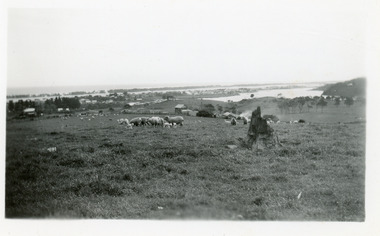
Photograph - Butcher's Paddock, Clark, Ruth, 1945c
Also second print 7 x 11.5Black and white photograph of the North Arm and township, taken from Allens Hill, looking across the Butcher's Paddock. It shows the slaughter house, sheep, lambs and other animals in the paddock. Lakes Entrance Victoriawaterways, topography, township, animals -
 Lakes Entrance Historical Society
Photograph - Lakes Entrance, 1935c
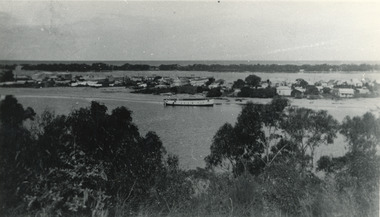
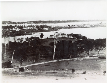
Enlarged from postcard produced for Mrs Allen to advertise Allen's Tearoom at the brow of Myer St hill, known as Allen's Hill to locals.|This is the paired before photograph showing the left hand side on Butchers paddock in the panoramic views, the right hand side number 01715. This photograph used in the 150 year Lakes Entrance 1858-2008 display.Black and white photograph of the township, taken from Allen's Hill, Myer St. It shows the town between Cunninghame Arm and North Arm, cleared and fenced paddocks in foreground, New Works village and sand hummocks in distance. Lakes Entrance Victoria township, waterways, topography -
 Lakes Entrance Historical Society
Photograph - Carpentertown, 1900c
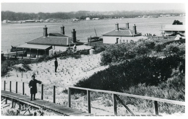
Also black and white copy 9 x 13 cmBlack and white photograph showing buildings on dunes. From left is harbour masters house, harbour engineers house, and Carpenters house. Child on boardwalk and newly planted marram grass on dune. Township across Cunninghame Arm. Lakes Entrance Victoriawaterways, topography, township -
 Lakes Entrance Historical Society
Photograph - Lakes Entrance, Bulmer H D, 1940c
Black and white photograph of aerial view of township. It shows route of Princes Highway through town, turning north at Myer Street and continuing along Roadknight Street. Few jetties on North Arm, many on Cunninghame Arm. In far upper left of image sea is breaking on sand hummocks. Lakes Entrance Victoriawaterways, township -
 Lakes Entrance Historical Society
Photograph - Princes Highway Lakes Entrance, 1930c
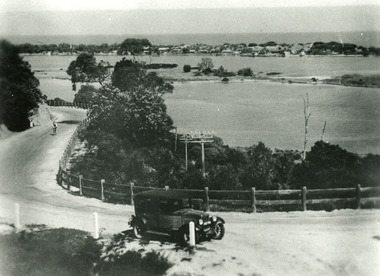
Black and white photograph of the Princes Highway as it winds around Jemmys Point. It shows a car parked in foreground, person on bicycle riding up hill, lake, Bullock Island and the township in distance. Lakes Entrance Victoria transport, roads and streets, waterways, township -
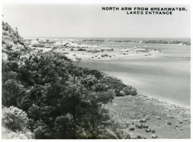 Lakes Entrance Historical Society
Postcard - North Arm Lakes Entrance, 1945c
One other copy same sizeBlack and white small format postcard of the entry to the North Arm, taken from Jemmys Point. It shows a steep cliffside above the calm waters, township of Lakes Entrance and Cunninghame Arm, and sand hummocks of southern shore in distance. Lakes Entrance VictoriaNorth Arm from Breakwater - Lakes Entrancetownship, waterways, topography -
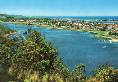 Lakes Entrance Historical Society
Postcard - Lakes Entrance, Engelander John & Co Pty Ltd, 1980c
Panoramic view of Lakes Entrance taken by Melbourne firm for West Germany A.F.K. International Publishers of world's most famous beauty spotsColour postcard with serrated edge, of the township, situated between Cunninghame Arm and North Arm. Boats moored at jetties and beside boat ramps in North Arm. Photo taken from Kalimna Heights. Dredged sand dumped in North Arm bight. Lakes Entrance VictoriaLakes Entrance, Victoria, Australia (on back) waterways, topography, township -
Bendigo Historical Society Inc.
Map - STRATHFIELDSAYE, See above
Map: Township of Strathfieldsaye, Group of 4 plans, 2 hand drafted and 2 printed. Applied to canvas and stapled to the backing. The printed plans are dated January 1859 and 6th January 1871 (number 267 in map cupboard 1)map, bendigo, township, strathfieldsaye -
Whitehorse Historical Society Inc.
Map, Plan of the Parish of Nunawading, 1853
Photocopy of map showing names of selectors, also list of references to the corners of allotments.Photocopy of map showing names of selectors, also list of references to the corners of allotments. Note on verso:'Gardiners Creek, Ballyshanassey township surveyed by H. Parmein, Surveyor General's Office Nov 30, 1853 also Reference to the Corners of allotments' (Plan 428)Photocopy of map showing names of selectors, also list of references to the corners of allotments. land subdivision, gardiners creek, ballyshanassy, parmein, h, burwood east, maps -
Whitehorse Historical Society Inc.
Map, Parish of Nunawading, 1853
Photocopy of manuscript map with allotments numbered and named.Photocopy of manuscript map with allotments numbered and named. Note on verso: Parish of Nunawading, County of Bourke. Gardiners Creek, Ballyshanassey Township, surveyed by H. Parmein, Surveyor General's office, Nov 30th 1853 [enlargement of ND2801, no list of corner references]Photocopy of manuscript map with allotments numbered and named. maps, gardiners creek, ballyshanassy, burwood east, parmein, h -
Bendigo Historical Society Inc.
Map - SERPENTINE, No date Visible
Map: Township of Janiember (name crossed out and 'Serpentine' hand written in its place, Parish of Janiember east, County of Bendigo ( number 156 in Map Cupboard 1)map, bendigo, township, serpentine, janiember, parish of janiember east, county of bendigo