Showing 545 items
matching vegetation
-
 Lakes Entrance Regional Historical Society (operating as Lakes Entrance History Centre & Museum)
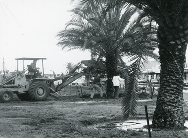
Photograph, 1992
Date made March 1992Black and white photograph of workers planting two mature date palm trees in the waterfront garden. It shows a work team completing the planting of one tree, the other surrounded by pool of water. Lakes Entrance Victoriaoccupation, waterfront, township, vegetation -
 Lakes Entrance Regional Historical Society (operating as Lakes Entrance History Centre & Museum)
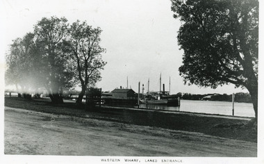
Photograph, 1910c
Black and white photograph of the Western Wharf, colloquially known as the Post Office Jetty. It shows a steamer moored at the wharf beside a sail powered vessel. There is a shed at the end of the jetty, another near the shore. Some banksia trees on bank, also small tree inside tree guard. Unsealed road in foreground. Lakes Entrance VictoriaWestern Wharf Lakes Entrancejetties, township, ships and shipping, vegetation -
 Wooragee Landcare Group
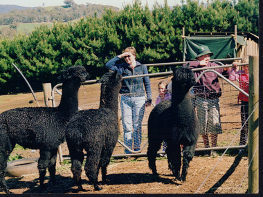
Photograph, 5 September 2004
This photograph was taken at Samaria Farm on Sunday the 5th of September as part of a day trip by the Wooragee Landcare Group. The event was about looking at land use on small farms and as a social get-together for the Group. Wooragee Landcare was also researching how small landholders could run some enterprises around the time of this trip. Samaria Farm is located in northeast Victoria, near Mount Samaria, which is located 130 km northeast of Melbourne. Samaria Farm was owned by Sue and Due Matheson at the time of the trip and had a renowned rose garden, pigs, poultry, alpacas, and goats on their nine-hectare farm. The rose garden consists of 3000 damask roses. Samaria Farm distils the oil from these roses and is the only farm in Australia to do this. Rose oil has historically been used for religious and medical use. 20 kg of rose buds are picked by hand every day, which is then distilled and produced 5 to 8 ml of oil. The entire four-week season produces 80 to 100 ml of oil. Rose water is also created during this process and produces about 300 litres per season. Along with the oil, the Farm also harvests lemons, lime, olives, and oranges. The Farm is currently owned by Utako and Anthony since 2022, with Vicki and Allan Wight being the previous owners. Wooragee Landcare Group was created in 1988. Its core mission is to work towards eradicating animals and pests from the land to protect the natural vegetation and promote revegetation projects. This photograph is a great example of the type of events that Wooragee Landcare Group has organized, while educating the public about the importance of land use management. The group is important to the community and for the environment. Landscape colored photograph printed on gloss paperReverse: WAN NA E0NA2N2. ANN+ 1 4240/ [PRINTED] (No. 19) / 372samaria farm, wooragee landcare group, wooragee, victoria, mount samaria, farming, roses, rose oil, damask roses, agriculture, pests, vegetation -
 Kiewa Valley Historical Society
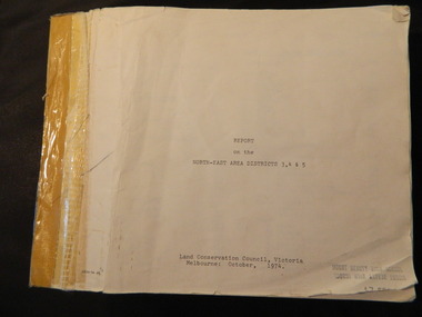
Report - Land Conservation Council x2, Land Conservation Council, Victoria Melbourne, April 1978, October 1974
Land Conservation Act 1970 established the Land Conservation Council to investigate and recommend to the Minister use of public land in Victoria. It describes and assesses the natural resources:-Physiography, Geology, Topography, Land Systems, Outdoor Recreation, Public land and blocks. Primary Production. Vegetation.North East Victoria includes the Kiewa Valley. This report gives an understanding of the development of the area.Thick heavy book with 312 pages with black and white photos. Back half has a folder with heavy cardboard attached to thick cardboard back cover. Inside folder are 9 maps with color each with a different title.Stamped on Front Cover: "Mount Beauty High School" Has a library borrowing slip at the back of the last page.land conservation council, environment, public land, kiewa valley, planning -
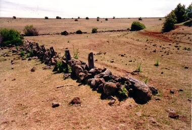
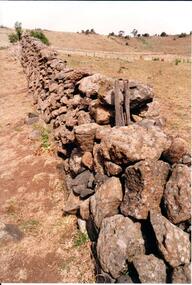 Hume City Civic Collection
Photograph, Early 1990's
This is a photograph of one of the many stone ruins which can be seen in the Sunbury area and surrounding districts. These ruins are found in varying degrees of structural damage caused by erosion, vegetation growth and vandalism. The post and stone fence at Emu Creek at Bulla is more intact in this photograph.A coloured photograph of a post and stone fence surrounded by sun drenched paddocks.stone structures, post and stone fences, emu creek, george evans collection -
 Wycheproof & District Historical Society Inc.
Wool Picture, Wycheproof Craft Group Emblem, 1984 (exact)
The Wycheproof Craft Group emblem made by Mrs Elaine Storey depicts a large ram and showcases beautifully, wool colours and versatility of creator and medium used. The wool industry, since Wycheproof's settlement days, has greatly supported the town, families and farming in general.The wool picture is the emblem of a local group that met between 1977 and 2010.This item is aesthetically significant as a visually pleasing craft piece that demonstrates the adaptability of skills to raw materials.It is representative of the lifeblood of the town of Wycheproof for 145 years.A framed wool picture constructed entirely from natural fleece, showing a merino ram in a paddock with natural looking vegetation growth. The subject aptly lends itself to a subtle display of various shades of wool colours. It is framed in oak wood.The word WYCHEPROOF is worked in fleece in an arc formation.Wycheproof Craft Group 1977-2010storey, wycheproof craft, wycheproof wool, spinners weavers, elaine -
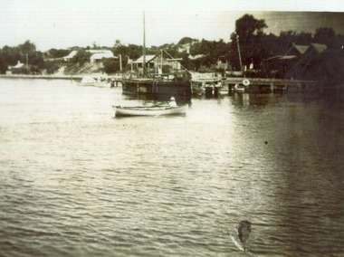 Lakes Entrance Regional Historical Society (operating as Lakes Entrance History Centre & Museum)
Photograph, 1925c
Two black and white copies 10 x 15 cmBlack and white photograph showing view from lake, and Cunninghame Arm, towards hummocks. Houses on dunes, Carpenter house far right. Lady Harriet barge at end of jetty, ten year old boy, Reg Schulz, in rowing boat. Vegetation on dunes. Lakes Entrance Victoriafences, houses, waterfront, recreation -
 Lakes Entrance Regional Historical Society (operating as Lakes Entrance History Centre & Museum)
Photograph, 1940 c
Also a colour photograph of staircase from the wreck of the S S Riverina in the hotel at Cann River 04639.1 15 x 10 cm donated by Babs Harris 20 May 2001Black and white photograph of hotel and garage on opposite corner of Prines Highway, shed at back of hotel, petrol bowsers in front advertising Super Plume petrol and castol oil. Road narrow with large grassed area in centre, tall trees and vegetation close to buildings Cann River Victoriapublic works, topography -
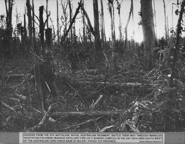 National Vietnam Veterans Museum (NVVM)
Photograph, Gibbons, Denis, Hat Dich Bunker Complex
A black and white photograph of diggers from 8th Battalion, Royal Australian Regiment, battle their way through mangled vegetation following massive artillery fire on a bunker complex in the Hat Dich arae South West of the Australian Task Force Base at Nui Dat, Phuoc Tuy Provincephotograph, 8 rar, nui dat, gibbons collection catalogue, 8th battalion, australian task force, phuoc tuy province, hat dich -
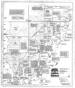
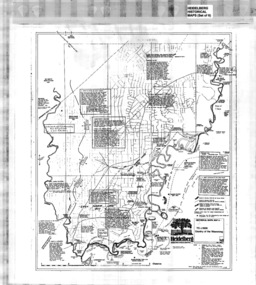 Greensborough Historical Society
Map, Heidelberg: Historic River Landscape Assessment, Historical Maps. Map A To 1838. Country of the Wawarang, 1985c
Geographical area of around 35 sq. kilometres marked with physical features such as major roads, rivers, vegetation and properties, with contemporary notes on landowners, descriptions and comments on the land and its development. Bounded by Shire of Diamond Valley to the North, Darebin Creek to the West and Plenty River to the East.Black an white sketch map on white paperheidelberg, heidelberg - maps -
 Greensborough Historical Society
Map, Heidelberg: Historic River Landscape Assessment. Historical Maps. Map B 1838-1851, "The Distinctly aristocratic locality", 1985c
Geographical area of around 35 sq. kilometres marked with physical features such as major roads, rivers, vegetation and properties, with contemporary notes on landowners, descriptions and comments on the land and its development. Bounded by Shire of Diamond Valley to the North, Darebin Creek to the West and Plenty River to the EastBlack and white sketch map on white paperheidelberg, heidelberg - maps -
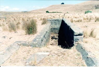 Hume City Civic Collection
Photograph, Early 1990's
This is a photograph of one of the many stone ruins which can be seen in the Sunbury area and surrounding districts. These ruins are found in varying degrees of structural damage caused by erosion, vegetation growth and vandalism. The bluestone structure was a sheep dip on the 'Karoora Park' property near Jacksons Creek.A coloured photograph of the stone remains of a sheep dip constructed from basalt rock. The ground at the entrance slopes down into a narrow walled channel. The surrounding paddocks are covered with tussocks of grass and there are bare hills in the background. The grass is brown.stone structures, sheep dips, basalt rock, 'karoora park', george evans collection -
 Hume City Civic Collection
Photograph, Early 1990's
This is a photograph of one of the many stone ruins which can be seen in the Sunbury area and surrounding districts. These ruins are found in varying degrees of structural damage caused by erosion, vegetation growth and vandalism. The remains of the post and stone fence can be seen near Emu Creek at Bulla.A coloured photograph of the remains of a low post and stone fence in a sunburnt paddock. There are a few low growing bushes dotted across the paddocks.stone structures, dry stone walls, post and stone fences, george evans collection -
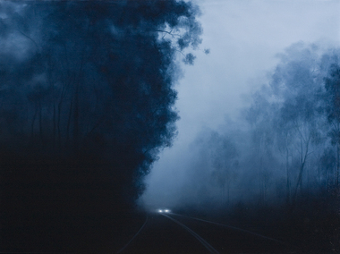 Nillumbik Shire Council
Painting: Camilla TADICH, Camilla Tadich, 6.23am Kangaroo Ground, 2009
Tadich spends time observing night time phenomena, the light from the moon, street lights and other sources; atmospheric states, fog and dampness and the nature of surfaces, vegetation, road, vehicles and buildings. She uses photographs and sketches before settling on the final idea for a work.This painting is typical of Tadich's recent work. She continues her exploration of the Australian landscape (most often the local, Nillumbik Shire). It is 'a dramatic interplay between narrative, landscape and the binaries of light/dark and the known/unknown of local landscape. The swathes of darkness within the work(s) pose questions about our inscribed fears and tensions, both cultural and existential'. (catalogue, 'Silent Space' Ex. 2006) Tadich's early experiences of fireworks, simple fireworks and bonfire in the surrounding bush of her outer Melbourne home, caught her imagination. She was inspired to investigate the issues surrounding nights in the bush. In this painting the narrative is ambiguous, the pinpricks of light, in this case from the car headlights provide a critical element. We can distinguish familiar features, a road, trees and a car that suggest human presence. However, what is going on is unclear. The resulting tension can leave us unsure, unsettled and anxious.Oil on canvascamilla tadich, nillumbik shire council, kangaroo ground -
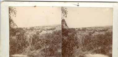 The Beechworth Burke Museum
Photograph - Stereoscopic Photograph
This photograph offers a view of Beechworth, located at the foot of the Victorian Alps. It captures the gorge and native vegetation in the foreground, with the Beechworth township visible in the middle, where the hospital is marked with an arrow. Distant hills form the backdrop. Originally settled c1839, Beechworth was officially proclaimed a town in 1856.This photograph is historically significant as it captures the landscape of Beechworth, providing valuable insight into the town's visual and historical character.Two sepia-toned square photographs showing the view of a town with trees in the foreground and hills in the far distance, mounted.Obervse: Above the right photograph there is an arrow pointing down. Reverse: 97.2195/ View across the Gorge/ looking over Beechworth/ (Hospital under arrow)/ 84-110-1/ A03082beechworth, town, landscape, ovens district, stereoscopic -
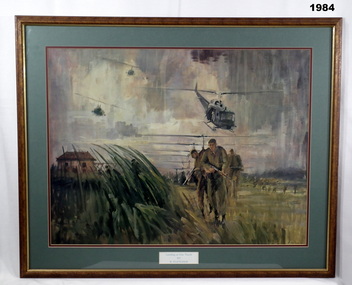 Bendigo Military Museum
Print - PRINT, FRAMED, Landing at Duc Thanh by B Fletcher
Print of an original Painting - Titled "Landing At Duc Thanh" by B Fletcher, coloured print of various soldiers and helicopters on landing, with vegetation in foreground. Frame - Light Timber with decorative edge - marbled brown colour finish. Glass front. Mount - double mount, mid green, dark red inner.Light green print below picture "Landing at DUC THANH/ by/ B. FLETCHER" framed print, battle, vietnam -
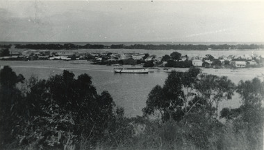 Lakes Entrance Regional Historical Society (operating as Lakes Entrance History Centre & Museum)
Photograph, 1945 c
The Hulk of the Baang Yarnda on the North Arm foreshore. (Note in album)Black and white photograph showing view from Kalimna cliff overlooking North Arm and township, Cunninghame Arm and sand dunes out to Bass Strait. Hulk of old Baang Yarnda moored in North Arm, towed there in 1939 and left to rot. Thick vegetation in foreground. Lakes Entrance Victoria.boats and boating, shipyard -
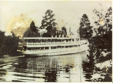 Lakes Entrance Regional Historical Society (operating as Lakes Entrance History Centre & Museum)
Photograph, 1910 c
Black and white photograph showing the S S Gippsland in Mitchell river, near Bairnsdale, shows three pine trees, other vegetation and a building on far bank, reflections in river,people on board, hull painted white, similar to a Bulmer postcard showing ship leaving Bairnsdale. Bairnsdale Victoriajetties, ships and shipping, waterways -
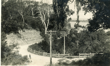 Lakes Entrance Regional Historical Society (operating as Lakes Entrance History Centre & Museum)
Postcard, Bulmer H D, 1940c
Black and white postcard of a bend in the Prince's Highway as it winds around Jemmys Point. Steep road cutting on upper side of gravel road, post and rail fence on lower side, schoolboy sitting on fence in foreground, dense vegetation on top of cutting and gully beneath road. Lakes Entrance VictoriaA bend in the Princes Highway, Lakes Entrancefences, transport, roads and streets, islands -
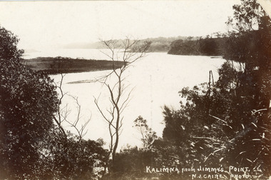 Lakes Entrance Regional Historical Society (operating as Lakes Entrance History Centre & Museum)
Postcard, Caire Nicholas John, 1905c
Also black and white enlargement 16 x 25Black and white postcard of the lake below Jemmys Point, Gippsland Lakes, showing Rigby Island opposite the steep cliffs of Kalimna and Nungurner shores of lakes. Small island, known as the Doughboy of Rigby Island. View taken from Jemmys Point with natural vegetation in foreground. Lakes Entrance VictoriaKalimna from Jimmys Pointislands, waterways, topography, boats and boating -
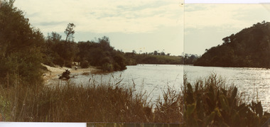 Lakes Entrance Regional Historical Society (operating as Lakes Entrance History Centre & Museum)
Photograph, Fish Marie, 1980
Two photographs stitched together to show a panoramic view.Colour photograph showing view of Lake Bunga, near Lakes Entrance, looking upstream from near the entrance. Tramway bridge almost gone. Some piles remain. Vegetation on sides of lake, background hill cleared, seats along the shoreline, lake full and clean. Lake Bunga Victoriabridges, waterways -
 Hume City Civic Collection
Photograph, Early 1990's
This is a photograph of one of the many stone ruins which can be seen in the Sunbury area and surrounding districts. These ruins are found in varying degrees of structural damage caused by erosion, vegetation growth and vandalism. The adit and mullock heap is from one of the mines on Redstone Hill. It was known as Batey's Mine.A coloured photograph of the remains of a mullock heap and adit from a mine. The entrance is surrounded by low growing trees and grass.stone structures, batey's mine, gold mining, redstone hill, george evans collection -
 Greensborough Historical Society
Article - Website, National Trust of Australia (Victoria), Mont Park: Statement written by National Trust of Australia (Victoria), 17/09/2010
Statement of Cultural heritage Significance for Mont Park acquired by Victorian state government in 1909 and used as a mental hospital complex comprising Larundel Kingsbury and Greswell facilities, finally decommissioned in1969. Contains extensive descriptions of regionally significant indigenous and exotic vegetation, landscaped by designer Hugh Linaker.2p. typescriptmont park, larundel, gresswell, hugh linaker -
 National Vietnam Veterans Museum (NVVM)
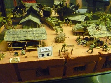
Model - Diorama, Cordon and Search
Diorama depicts a village with the huts / houses one covered storage area, two APC'S, Barrow with wood, pig pen,tunnels by three, boat on waterway and soldiers (searching for VC) Scenery includes trees and vegetation, wood piles and house hold items.C1967 Diorama is in two pieces joined by landing bridge.diorama -
Lakes Entrance Regional Historical Society (operating as Lakes Entrance History Centre & Museum)
Photograph, Lakes Entrance Tidy Town Committee, 2000 c
Also three other colour photographs taken the same day of vegetation on dunes between ocean and golf club greens 04279.1 04279.2, 04279.3 which shows view across Warm Holes to Golf Club No 1 green adjacent to Eastern Beah all 10 x 115 cmColour photograph showing Brian Klemm of Keep Australia Beautiful Council with Margaret Daly and Trish Haberfield of Tidy Town Committee with John Stapleton Robert Blackham Tony McDonough Barry McKenzie and Trevor McCubbin of LE Golf Club inspecting stabilisation work on dunes beside greens Lakes Entrance Victoriatownship, people -
 Otway Districts Historical Society
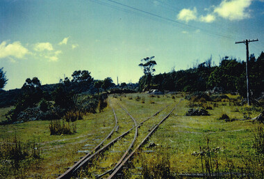
Photograph, Doug McLean, Crowes: station yard, 1960, 1960
In 1960 the Crowes railway station and yards had been closed for six years, since December 1954. This section was left to the elements, the line being rapidly covered with vegetation. This had to be cleared when rail recovery trains ran again to Crowes when the track was being pulled up in 1961.Colour. Crowes station yard in 1960; two tracks diverging from one. Not two cars in the middle distance. crowes; railway; -
 Kiewa Valley Historical Society
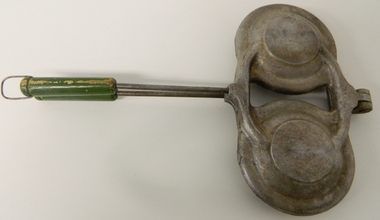
Pie Iron Camping, circa mid to late 1900s
This Pie Iron was used in the mid to late 1900's when stock, both cattle and sheep, were grazed on the Bogong High Plains. Providing meals for stockmen over open fires, even in log cabins in the Victorian Alpine region, was usually by a "camp cook" or a stockman designated "cook" from the Valley station/property. The use of "camping cooking utensils were a necessity and not a "weekend" affair. Stockmen could spend up to six weeks on the plains and all their cooking needs required had to "pack horsed" from the valley below. A scientific study started in 1947, to study the impact of grazing cattle on the natural Alpine and sub Alpine vegetation found grazing cattle had an adverse affect on the natural Alpine and sub alpine vegetation, and grazing on the plains was stopped by the Victorian Government in 2005.This item is highly significant to the Kiewa Valley as it demonstrates the kind of cooking utensils that were required for camp drafts in the Bogong High Plains environment. As the control of cattle and sheep in the High Plains was very demanding upon horse and rider, good "tucker" was a pre- requisite for a successful operation. As the time spent in this remote location was governed by the climatic condition maximum utilisation of the very good pastures in the High Plains was crucial to a successful and profitable season.This pie iron has two pie forms in horizontal configuration and both top and base rounded forms are connected at one end (Top) with pop rivet application. This application allows for the "opening" up of the two halves. The bodies are made from cast iron in a "cup" form and a metal rod and wooden handle extend to permit the opening of the two sides. The inner side of the "cups" are smooth which relates to pie requirements and not the jaffle/sandwich irons. A clasp metal "D" ring is installed at the end of one wooden handle (to keep the iron in the close/cooking position).camp fire cooking utensils, hot plate, cast iron cooking appliances, pie irons, jaffle irons, drovers kitchen -
 Bendigo Military Museum
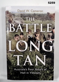
Book - BOOK, VIETNAM WAR BATTLE, David W. CAMERON, "The Battle of Long Tan", 2016
"The Battle of Long Tan/ Australia's Four Hours of Hell in Vietnam".Soft cover book. Soft cover - cardboard, white and light gold print on front, spine and back. Illustrated - colour photograph from front to back of soldiers resting in foreground, helicopter in background, with jungle vegetation. 392 pages - paper, cut, plain, white. Illustrated colour, sepia and black and white photographs.books, history, vietnam war -
 Lakes Entrance Regional Historical Society (operating as Lakes Entrance History Centre & Museum)
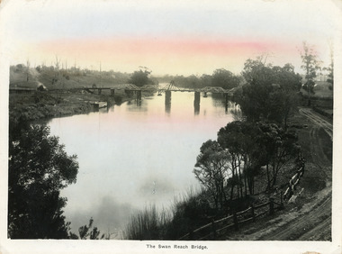
Postcard, Bulmer, H D, 1915
Colour tinted large format postcard showing lifting bridge over the Tambo River, at Swan Reach, Victoria. Bridge is closed to allow road traffic through. Rough gravel road to Metung on right. Landing on left near bridge. Vegetation on river bank right. Houses in distance on both sides of river.The Swan Reach Bridgeboats and boating, bridges -
 Bendigo Historical Society Inc.
Document - PETER ELLIS COLLECTION: INFORMATION ON THE BARFOLD GORGE
Foolscap page of information on the Barfold Gorge, by Frank Robbins. Barfold Gorge is compared with the Sydenham Organ Pipes National Park. There is a description of the Gorge. Native vegetation growing there is also mentioned. Turning it into a National Park is mentioned but it is in private ownership and this would require buy back of the land and create access problems as it is a farming area.place, land, barfold gorge, peter ellis collection, barfold gorge, sydenham organ pipes national park, campaspe river, mitchell's falls, queen's falls, piper's creek, turpin's falls, land conservation council, victoria conservation trust, frank robbins