Showing 2427 items
matching 1861-1865
-
 Clunes Museum
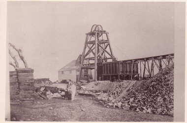
Photograph, C. NETTLETON, PORT PHILLIP AND COLONIAL GOLD MINING COMPANY, CLUNES, CIRCA 1865
CLUNES QUARTZ MINING COMPANY'S. SOUTH SHAFT. PERIOD 1865. SMALL SEGMENTS OF PHOTOGRAPH INCLUDED.PHOTOGRAPH .1 SEPIA PHOTOGRAPH OF PORT PHILLIP AND COLONIAL GOLD MINING COMPANY CLUNES. - POPPET HEAD AND BUILDINGS. .2 & .3 BLACK AND WHITE PHOTO PRINT OF PHOTOGRAPHPORT PHILLIP GOLD MINING CO. CLUNES. SOUTH SHAFT.local history, photography, photographs, mining -
 Bendigo Historical Society Inc.
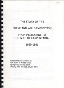
Book - THE STORY OF THE BURKE AND WILLS EXPEDITION, 2000
The Story of the Burke and Wills expedition, from Melbourne to the Gulf of Carpentaria 1860-1861 189 pages with photographs and maps.Ron Munroaustralia, history, explorers, australia-history-explorers -
 Whitehorse Historical Society Inc.
Document, Three years in Australia, n.d
Document written by Norma Jamieson re Clara Aspinall during the years 1858 - 1861 regarding life in Melbourne.aspinall, clara, social history -
 Bendigo Historical Society Inc.
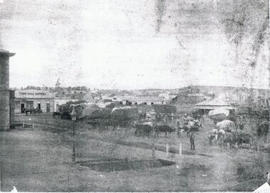
Photograph - MARKET SQUARE 1861, 1861
First town hall - 2 storey building at left. Town Hall Hotel on left. Many single storey building with covered drays and cattle in foreground. Rectangular drain in foreground with gas lamp at corner. Copy of original and very indistinct. James Lerk 28.2.2000 ' Batchelder photo ( copy ) 1861 Market Square'batchelderplace, streetscape, market square -
 Bendigo Historical Society Inc.
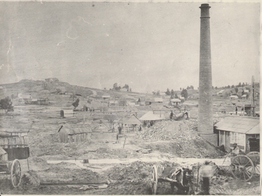
Photograph - GOLD MINES BENDIGO 1861, 1861
Copy of photograph of mine site with dwellings to right top, mine buildings, 'whim?' drays, horse and work men. Large brick chimney on right. B+W photo. On back 'Gold Mines Bendigo 1861','Probably, looking NW up New Chum Hill, which was then known as Sth Victoria Hill'.place, mining site, sth victoria hill ?, see also 131.01 -
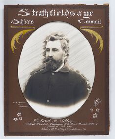 City of Greater Bendigo - Civic Collection
Photograph - Portrait of Councillor Sibley, W H Robinson
The district of Strathfieldsaye was proclaimed in 1861 and named a Shire on the 17th September in 1866. It remained a shire until amalgamation in 1994 when it became part of the City of Greater Bendigo. The shire was located 8 km to the south- east of Bendigo and covered an area of 601 square kilometres and extended from the Calder Highway to the Coliban and Campaspe Rivers. The shire's administration centre was in Strathfieldsaye until 1972 when new offices were opened in KenningtonFramed black and white head and shoulder portrait of Councillor Sibley with hand coloured and drawn detail. Profile slightly to left with walrus moustache and beard. Cut oval brown mount decorated with text, flowers and scrolls. Hand written title top and lower centre.Strathfieldsaye / Shire Council / W m Robinson / Photo / Bendigo / J N B Gribble / Cr Robert R Sibley / First President Chairman of the Road Board 1865 - 5 / President 1866 - 1869 / With Mrs Sibley's Complimentsstrathfieldsaye shire council, councillor sibley, president of strathfieldsaye shire -
 Ballarat Heritage Services
Photograph - Colour, Clare Gervasoni, Marysville Police Office, 2012, 15/12/2012
Four colour photographs of the Marysville Police Office which was built in the town circa 1865. The chimney bricks are original. bushfire, black saturday, marysville, marysville police office -
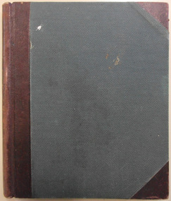
 Bendigo Historical Society Inc.
Book - GALLAGHER COLLECTION: REAL ESTATE SALES W. MCKEAN & CO, 1965
Book Record of all Real Estate Sales by W. McKean & Co. Dates April 1865 to February 1971 -
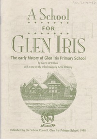 Camberwell Historical Society
Booklet (Item), Gwen McWilliam, A School for Glen Iris: The early history of Glen Iris Primary School, 1998
camberwell, glen iris, school -
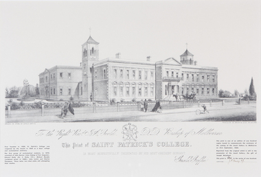
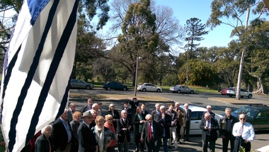 St Patrick's Old Collegians Association (SPOCA)
Photograph - SPOCA, Irish Jesuit 150-Years
-
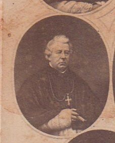 St Patrick's Old Collegians Association (SPOCA)
Photograph - History, SPJC General
-
 St Patrick's Old Collegians Association (SPOCA)
Photograph - Teachers, Jesuits
-
 Bacchus Marsh & District Historical Society
Map, Village allotments, Parish of Myrniong, County of Bourke
Myrniong is a village 9 kilometers west of Bacchus Marsh. Prior to 1863 the area was known as Blow's Flat. This map which was produced in 1903 and according to the catalogue record of this map held at the State Library of Victoria was based on an earlier map created in 1861. The early layout of streets for the village of Myrniong can be seen on this map. The streets shown are, Main Street, Hardy Street, Blow Street, Myrniong Street, Shuter Street, and Blackwood Street. An area marked as a reserve for a school can be seen between Hardy Street and Main Street.A single page paper map. A cadastral parish map of Myrniong in Victoria, showing numbered land allotments. Photo-lithographed at the Department of Lands & Survey, Melbourne, in 1903. Based on an original map created in 1861. The map is pasted into a bound volume containing 76 maps or plans in total. High resolution digital image stored on BMDHS computer network. Surveyed by John Hardy, Surveyor ; photo-lithographed at the Department of Lands & Survey, Melbourne by T.F. McGauran, 24.12.03myrniong parish plan, myrniong parish maps -
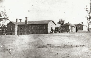 Bendigo Historical Society Inc.
Photograph - POLICE BARRACKS, C 1861
black and white photograph. Stone buildings and police barracks, Camp Hill, Bendigo. Barracks, Camp Hill, Bendigo, built in 1858 and completed the following year. Police are drilling outside the stone 'lock-up' Police officers' residence is at the rear. Photographed in 1861 by Batchelder. 134 photographed by Bill Hawking of Bendigo Advertiser 4.7.2000Batchelderorganization, government, police barracks -
 Bendigo Historical Society Inc.
Document - LYDIA CHANCELLOR COLLECTION: 93 MOLLISON STREET, BENDIGO
A six page document containing information on 93 Mollison Street Bendigo. Mr. Albert Bush first bought the land in 1865 and built the house in 1865. Included with the information is a letter to Miss Huxtable from Mr. Bob (Robert G.) Herriot an architect who purchased the house in 1973.bendigo, house, 93 mollison street, lydia chancellor collection, collection, building, home, albert bush, bendigo, house, houses, residence, mollison street, mr. robert g. herriot, architect -
 Bendigo Historical Society Inc.
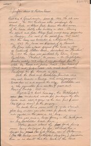
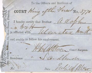
Document - ANCIENT ORDER OF FORESTERS NO 3770 COLLECTION: ADOLPHUS WITT
Blue slip signed by H. L. Atkinson, Court Surgeon, saying Adolphus Witt is unable to follow his employment and dated July 4/1865. White note from Adolphus Witt. Claiming sick allowance, signed by Adolphus Witt. Victoria Hill and dated July 4/1865. A second white note from Adolphus Witt declaring himself off the sick fund, dated July 15 1865. Signed by Adolphus Witt and H. L. Atkinson.Bro Clarke, Printer, 84 Moor St. Fitzroy, Adolphus Witt?, H L Atkinsonsocieties, aof, correspondence, ancient order of foresters no 3770 collection - adolphus witt, court king of the forest, adolphus witt, h l atkinson, bro clarke -
 Bendigo Historical Society Inc.
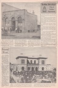
Newspaper - Trevor Lamb collection: Bendigo Advertiser Pictorial lift out
BHS CollectionFour pages pictorial lift out from the Bendigo Advertiser. Photographic sketches of Sandhurst, boom gold town of 1861. bendigo advertiser, sandhurst, 1861 -
 Bendigo Historical Society Inc.
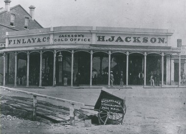
Photograph - HENRY JACKSON, GOLD BUYER OF VIEW POINT, CHARING CROSS, 1861
Black and white photograph. Single storey building with verandah. Two storey brick building at L. At least 12 adult males standing under verandah. L foreground wooden bridge / walkway. Photographer's car CF. In image on building 'Finlay & Co/Jackson's Gold Office, H Jackson'. On cart in image 'Photographer, Pall Mall'. Inclusion in envelope - typewritten is 'Henry Jackson, gold buyer of View Point, Charing Cross where Aussie Disposals are now operating. On the right is the first building of the Bank of New South Wales. The railing marked where the creek then meandered. Photograph by Batchelder, taken in 1861. (Bendigo Historical Society Inc.) History of object James Lerk 28.2.2000 Batchelder photo (copy) 1861, View Point. See Mosaic 1228 for further information.buildings, commercial, henry jackson, gold buyer -
 Clunes Museum
Article - TANKARD
COAT OF ARMS ENGRAVED. REFERENCE TO MINING ON SHIELDPewter tankard with a glass bottomHand engraved "Thos. Mark 1861" (With decorative surround) and the image of the Australian Coat of Armsdrinking vessel, tankard -
Whitehorse Historical Society Inc.
Document, The Life of a school, 1998
The Story of the Burwood Primary School (461) 1865-1989, and through to the partial restoration of the building by 1998.The Story of the Burwood Primary School (461) 1865-1989, and through to the partial restoration of the building by 1998, comp. by Ken BussellThe Story of the Burwood Primary School (461) 1865-1989, and through to the partial restoration of the building by 1998.burwood primary school, no. 461 -
 St Patrick's Old Collegians Association (SPOCA)
Photograph - Buildings, SPJC, Artworks, Griffin (1)
-
Port Melbourne Historical & Preservation Society
Book - Sandridge Municipal Council, Minute Book, c. 1860
Notebook with blue marbled cover and label: "Municipal Council of Sandridge Committee of the whole council" 1860 - 1865 (completely filled)local government - municipal district of sandridge, local government - borough of sandridge, health - general health, thomas swallow, william morley, andrew plummer -
Whitehorse Historical Society Inc.
Letter - Correspondence, Office of Lands and Survey, 1861
Copy of letter written by W. Fletcher, Office of Lands and Survey, Melbourne, 2 Nov 1861.Copy of letter written by W. Fletcher, Office of Lands and Survey, Melbourne, 2 Nov 1861. Reporting that charcoal burners in the Parish of Nunawading are using wood for that purpose without a license and suggesting the policeman at Whitehorse by informed. Attached note suggests author is possibly Walter Thomas Fletcher, early owner of land that included what is now Matheson's orchard (1988).Copy of letter written by W. Fletcher, Office of Lands and Survey, Melbourne, 2 Nov 1861.charcoal burning, fletcher, w, forest hill, parish of nunawading -
 Bendigo Historical Society Inc.
Newspaper - SANDHURST BEE, 1861
Newspaper - Bound collection of Sandhurst Bee newspapers. Volume is bound in buff coloured canvas type material (?) Papers date from July - October 1861. Inside front cover lined with brown paper, and brown paper front page. Written on inside front cover in black pen 'Property of Bendigo Branch Royal Victorian Historical Society'newspaper, bendigo, sandhurst, sandhurst bee -
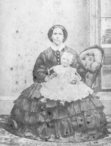 Ringwood and District Historical Society
Photograph, Mrs. Pett and Charlotte (b.13.2.1865.)
Black and white photograph of lady sitting in chair holding a child. Written on backing sheet, "Mrs. Pett and Charlotte (b. 13/2/1865)." -
 Clunes Museum
Photograph, 1865
VIEW IN TOWNSHIP CLUNES, SOUTH EAST. PERIOD 1865. TAKEN FROM HILLSIDE BELOW CAMP PARADE, VICINITY MR. SWANTON'S HOUSE PHOTOGRAPH OF TOWNSHIP OF CLUNES, SOUTH EAST .1 SEPIA PHOTOGRAPH MOUNTED ON CARDBOARD. .2 BLACK AND WHITE PRINT .3 SEPIA PHOTO PRINT .4 BLACK AND WHITE PHOTO PRINT .5 BLACK AND WHITE PHOTO PRINT HOUSES SURROUNDED BY PICKET FENCES, POPPET LEGS AND CHIMNEY STACK.VIEW IN TOWNSHIP CLUNES. SOUTH EAST.local history, photography, photographs, clunes township -
 City of Moorabbin Historical Society (Operating the Box Cottage Museum)
A laminated , photocopy of the ‘Plan of Box Cottage c 1865 ‘, 1985
The original small, pioneer cottage was built in the late 1840s to early1850s, by an unknown pioneer. It was located on part of a 30 Acre allotment that was originally part of Dendy’s Special Survey granted in 1841. The doors and window sashes, (made of red deal joinery timber), as well as the brass locks and fittings, are from the original cottage, and were imported from England. The fire-place bricks are from the original cottage, and are sun-dried, (not kiln fired), and are hand-made. Convict marks can be seen on two bricks. There is a small display of external cladding shingles from the original pioneer cottage. These shingles were hand-split, and most likely made from locally collected timber The nails included in this display were used to fasten the shingles on the original cottage, and are also hand-made. The cottage was occupied by William Box and family from 1865 until 1914 when it was sold to William Reitman who resided there until 1950. The enamel nameplate, “Colonial”, on the wall of the cottage, was the name chosen for the original pioneer cottage by Mr William Reitman, when he purchased the property in around 1915, for 1200 Pounds approximately. In 1974 Mr Lewis, a timber specialist, found the dilapidated building on property he had recently purchased in Jasper Rd and suggested it be reconstructed and relocated. Moorabbin Council agreed and the cottage was rebuilt just about 250 metres from its original site. The cost of the rebuild was met by 'Victoria's 150th Committee, plus a small grant from the City of Moorabbin, and Mr Laurie Lewis donated much of the timber for the reconstruction. The re-constructed cottage plan has followed faithfully the original dimensions, and plan of the original pioneer cottage, and as many original items from that cottage’s long occupation have been incorporated. The photographs in Album 1 record the progress of the reconstruction from February 1984 to the First Public Open Day November 18th 1984Mrs H Deam and Mr A. Smith, CMHS members, photographed the progress of the 'Reconstruction' from February 1984 to November 1984. Although 'Box Cottage' is a re-construction, it is an unique museum that, being located in the midst of a modern community in Ormond Victoria, can educate and demonstrate many aspects of the early settler’s way of life in Victoria. As such, it is an invaluable resource for students and all kinds of visitors. A laminated , photocopy of the ‘Plan of Box Cottage c 1865 ‘ Hand drawn layout of 2 houses with shrubs, trees, plants, wells, gardens on the Box Cottage site c1930 as recalled by Stefanie Rietman Rennick. brighton, moorabbin, cottages, pioneers, ormond, colonial, mckinnon, dendy henry, box william, box elizabeth, reitman william, convicts lewis timber co. ltd., deam h, museums, box alonzo, smith a, -
 Warrnambool and District Historical Society Inc.
Book, George Rolfe's Book of Abstracts, Circa 1865
Alphabetical entries about many topics from fruit trees to Legislation, to Senate of America George Rolfe came to Warrnambool in 1872 and by 1883 was well established on the banks of the Hopkins River at Lyndoch. In 1884 he purchased Shipley which also had frontage to the Hopkins River. He participated in the social and sporting life of Warrnambool and was a keen rower.An interesting collection of thoughts and life of one of the early merchants and farmers of the area. He was a generous benefactor of the hospital.Dark green hard cover with maroon spine and corners. Pages are lined and alphabetical. Hand written entries throughout. : Inside front cover is label ”Cook & Fox, Account Book Manufacturers, Stationers, Bookbinders machine Rulers, Importers 58 Queen St Melbourne. Handwritten on front page “G Rolfe Senr. Book for extracts 1865. warrnambool, george rolfe, lyndoch, book for extracts -
Port Melbourne Historical & Preservation Society
Letter - Department of Lands and Survey granting land for temporary reserve, 18 Mar 1860
Handwritten letter from Dept of Lands and Survey granting Crown land for temporary reserve as site for abattoirs 18 March 1861local government - borough of sandridge, industry - noxious, department of lands and surveys, clement hodgkinson -
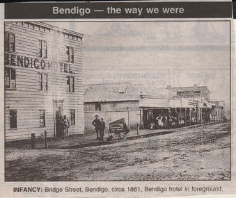 Bendigo Historical Society Inc.
Newspaper - JENNY FOLEY COLLECTION: INFANCY
Bendigo Advertiser ''The way we were'' from 1999. Infancy: Bridge Street, Bendigo, circa 1861. Bendigo hotel in foreground.newspaper, bendigo advertiser, the way we were