Showing 670 items matching "2009 black saturday bushfires"
-
 Marysville & District Historical Society
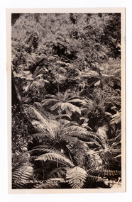
Photograph (item) - Black and white photograph, Valentine Publishing Co. Pty. Ltd, Cumberland Gully, Marysville No.5, 1923-1963
... 2009 black saturday bushfires... 2009 black saturday bushfires timber mills An early black ...An early black and white photograph of Cumberland Gully in the Cumberland Valley in Victoria.An early black and white photograph of Cumberland Gully in the Cumberland Valley in Victoria. This gully is are located near the Marysville-Wood's Point Road. Cambarville is notable for its giant mountain ash (Eucalyptus regnans) trees within the Cumberland Memorial Scenic Reserve, and relics from former sawmills and gold mining. The Big Culvert is located nearby on the Marysville-Woods Point Road, which was historically part of the Yarra Track. Cambarville was established as a timber mill town in the 1940s. Timber mill owners A Cameron and FJ Barton named Cambarville. They established the mill to salvage timber from trees destroyed in the 1939 bushfires. Cambarville was impacted by the 2009 Black Saturday bushfires and any remaining structures were destroyed. cumberland valley, cumberland gully, cambarville, marysville-wood's point road, eucalyptus regnans, cumberland memorial scenic reserve, mining, big culvert, yarra track, a cameron, fj barton, 1939 bushfires, 2009 black saturday bushfires, timber mills -
 Marysville & District Historical Society
Flyer (item) - Information flyer, Artworkz Tourism, Marysville-Historic Cambarville, 26-03-2016
... 2009 black saturday bushfires... in the 1939 bushfires. Cambarville was impacted by the 2009 Black ...A flyer that was produced as a guide to Cambarville near Marysville in Victoria.A flyer that was produced as a guide to Cambarville near Marysville in Victoria. Cambarville is notable for its giant mountain ash (Eucalyptus regnans) trees within the Cumberland Memorial Scenic Reserve, and relics from former sawmills and gold mining. The Big Culvert is located nearby on the Marysville-Woods Point Road, which was historically part of the Yarra Track. Cambarville was established as a timber mill town in the 1940s. Timber mill owners A Cameron and FJ Barton named Cambarville. They established the mill to salvage timber from trees destroyed in the 1939 bushfires. Cambarville was impacted by the 2009 Black Saturday bushfires and any remaining structures were destroyed. cambarville, marysville, victoria, mountain ash, eucalyptus regnans, cumberland memorial scenic reserve, timber milling, big culvert, marysville-woods point road, yarra track, a cameron, fj barton, 2009 black saturday bushfires -
Marysville & District Historical Society
Flyer (item) - Information flyer, Artworkz Tourism, Marysville-Cora Lynn Falls, 20-04-2018
... 2009 black saturday bushfires... 1939 bushfires 2009 black saturday bushfires timber mills ...A flyer that was produced as a guide to the Cora Lynn Falls near Marysville in Victoria.A flyer that was produced as a guide to the Cora Lynn Falls near Marysville in Victoria. These falls are located on the Marysville-Wood's Point Road. Cambarville is notable for its giant mountain ash (Eucalyptus regnans) trees within the Cumberland Memorial Scenic Reserve, and relics from former sawmills and gold mining. The Big Culvert is located nearby on the Marysville - Woods Point Road, which was historically part of the Yarra Track. Cambarville was established as a timber mill town in the 1940s. Timber mill owners A Cameron and FJ Barton named Cambarville. They established the mill to salvage timber from trees destroyed in the 1939 bushfires. Cambarville was impacted by the 2009 Black Saturday bushfires and any remaining structures were destroyed.marysville, victoria, photograph, cora lynn falls, waterfalls, cambarville, marysville-wood's point road, eucalyptus regnans, cumberland memorial scenic reserve, mining, big culvert, yarra track, a cameron, fj barton, 1939 bushfires, 2009 black saturday bushfires, timber mills -
Marysville & District Historical Society
Booklet (item) - Information booklet, Artworkz Tourism, Cora Lynn Falls, Unknown
... 2009 black saturday bushfires.... Cambarville was impacted by the 2009 Black Saturday bushfires and any ...An information booklet that was produced as a guide to the Cora Lynn Falls near Marysville in Victoria.An information booklet that was produced as a guide to the Cora Lynn Falls near Marysville in Victoria. These falls are located on the Marysville-Wood's Point Road. Cambarville is notable for its giant mountain ash (Eucalyptus regnans) trees within the Cumberland Memorial Scenic Reserve, and relics from former sawmills and gold mining. The Big Culvert is located nearby on the Marysville - Woods Point Road, which was historically part of the Yarra Track. Cambarville was established as a timber mill town in the 1940s. Timber mill owners A Cameron and FJ Barton named Cambarville. They established the mill to salvage timber from trees destroyed in the 1939 bushfires. Cambarville was impacted by the 2009 Black Saturday bushfires and any remaining structures were destroyed.marysville, victoria, photograph, cora lynn falls, waterfalls, cambarville, marysville-wood's point road, eucalyptus regnans, cumberland memorial scenic reserve, mining, big culvert, yarra track, a cameron, fj barton, 1939 bushfires, 2009 black saturday bushfires, timber mills -
 Marysville & District Historical Society
Photograph (Item) - Black and white photograph, Bridge Over The Cumberland, c1900
... 2009 black saturday bushfires... barton 2009 black saturday bushfires ARMSTRONG COLLECTION 42 ...An early black and white photograph of a bridge over the Cumberland Creek near Marysville in Victoria.An early black and white photograph of a bridge over the Cumberland Creek near Marysville in Victoria. The Cumberland Creek is in the Cumberland Valley near Cambarville which was a timber town near Marysville. Cambarville is notable for its giant mountain ash (Eucalyptus regnans) trees within the Cumberland Memorial Scenic Reserve, and relics from former sawmills and gold mining. The Big Culvert is located nearby on the Marysville - Woods Point Road, which was historically part of the Yarra Track. Cambarville was established as a timber mill town in the 1940s. Timber mill owners A Cameron and FJ Barton named Cambarville. They established the mill to salvage timber from trees destroyed in the 1939 bushfires. Cambarville was impacted by the 2009 Black Saturday bushfires and any remaining structures were destroyed.ARMSTRONG COLLECTION 42 STATION STREET/ SANDRINGHAM 3191/ TEL. (03) 9521 5442/ IAN M.L. ARMSTRONG OAMcumberland creek, marysville, victoria, cumberland valley, cambarville, mountain ash, eucalyptus regnans, cumberland memorial reserve, the big culvert, marysville-wood's point road, yarra track, a cameron, fj barton, 2009 black saturday bushfires -
 Marysville & District Historical Society
Booklet - Information booklet, Ann Thomas, Wilks Creek Bridge, 1993
... 2009 black saturday bushfires... of the bridge were destroyed in the 2009 Black Saturday fires ...A history of the Wilks Creek Bridge and its connection to the Yarra Track.Paperback. Front cover has an old photograph of the Wilks Creek Bridge.non-fictionA history of the Wilks Creek Bridge and its connection to the Yarra Track.wilks creek bridge, yarra track, narbethong, marysville, victoria, clement wilks, wood's point goldfields, jordan goldfields, john monash, monash and anderson, 2009 black saturday bushfires -
 Marysville & District Historical Society
Photograph (Item) - Colour photograph, Pre 2009
... 2009 black saturday bushfires... john monash monash and anderson 2009 black saturday bushfires ...A colour photograph of the Wilks Creek Bridge near Marysville in Victoria.A colour photograph of the Wilks Creek Bridge near Marysville in Victoria. The Wilks Creek Bridge is a former timber and bluestone road bridge on the Yarra Track, and is located just off the Black Spur route, between Narbethong and Marysville, Victoria, Australia. It was built in 1870 to the design of colonial Public Works Department engineer Clement Wilks as part of the construction of a new road to the Woods Point and Jordan Goldfields. Like many bridges of the period, it had a timber superstructure employing squared beams supported by struts and straining pieces, on cut bluestone abutments. The bridge was remodelled around 1900 by engineer John Monash of the famous bridge-engineering firm of Monash and Anderson. It was last used for heavy vehicular traffic in 1980 following the realignment of Marysville Road, and was left to decay until its demolishment in 2008. All timber traces of the bridge were destroyed in the 2009 Black Saturday fires. The handcrafted bluestone masonry wingwalls and abutments, especially shaped to receive timber struts, rate among the earliest of its kind surviving intact in Victoria.wilks creek bridge, yarra track, narbethong, marysville, victoria, clement wilks, wood's point goldfields, jordan goldfields, john monash, monash and anderson, 2009 black saturday bushfires -
 Marysville & District Historical Society
Photograph (Item) - Black and white photograph, 1993
... 2009 black saturday bushfires... of the bridge were destroyed in the 2009 Black Saturday fires ...A black and white photograph taken at the re-opening of the Wilks Creek Bridge picnic area and launch of Ann Thomas' book Wilks Creek Bridge.A black and white photograph taken at the re-opening of the Wilks Creek Bridge picnic area and launch of Ann Thomas' book Wilks Creek Bridge. The Wilks Creek Bridge is a former timber and bluestone road bridge on the Yarra Track, and is located just off the Black Spur route, between Narbethong and Marysville, Victoria, Australia. It was built in 1870 to the design of colonial Public Works Department engineer Clement Wilks as part of the construction of a new road to the Woods Point and Jordan Goldfields. Like many bridges of the period, it had a timber superstructure employing squared beams supported by struts and straining pieces, on cut bluestone abutments. The bridge was remodelled around 1900 by engineer John Monash of the famous bridge-engineering firm of Monash and Anderson. It was last used for heavy vehicular traffic in 1980 following the realignment of Marysville Road, and was left to decay until its demolishment in 2008. All timber traces of the bridge were destroyed in the 2009 Black Saturday fires. The handcrafted bluestone masonry wingwalls and abutments, especially shaped to receive timber struts, rate among the earliest of its kind surviving intact in Victoria.wilks creek bridge, yarra track, narbethong, marysville, victoria, clement wilks, wood's point goldfields, jordan goldfields, john monash, monash and anderson, 2009 black saturday bushfires -
Marysville & District Historical Society
Document (Item) - Heritage Report, Biosis Research Pty Ltd, Heritage Report-Dismantling of Wilks Creek Brdige Deck Marysville, Unknown
... 2009 black saturday bushfires... of the bridge were destroyed in the 2009 Black Saturday fires ...A heritage report on the dismantiling of the Wilks Creek Bridge deck in Marysville in Victoria.A heritage report on the dismantiling of the Wilks Creek Bridge deck in Marysville in Victoria. The Wilks Creek Bridge is a former timber and bluestone road bridge on the Yarra Track, and is located just off the Black Spur route, between Narbethong and Marysville, Victoria, Australia. It was built in 1870 to the design of colonial Public Works Department engineer Clement Wilks as part of the construction of a new road to the Woods Point and Jordan Goldfields. Like many bridges of the period, it had a timber superstructure employing squared beams supported by struts and straining pieces, on cut bluestone abutments. The bridge was remodelled around 1900 by engineer John Monash of the famous bridge-engineering firm of Monash and Anderson. It was last used for heavy vehicular traffic in 1980 following the realignment of Marysville Road, and was left to decay until its demolishment in 2008. All timber traces of the bridge were destroyed in the 2009 Black Saturday fires. The handcrafted bluestone masonry wingwalls and abutments, especially shaped to receive timber struts, rate among the earliest of its kind surviving intact in Victoria.wilks creek bridge, yarra track, narbethong, marysville, victoria, clement wilks, wood's point goldfields, jordan goldfields, john monash, monash and anderson, 2009 black saturday bushfires -
Marysville & District Historical Society
Document (item) - Memories document, Catherine Stabb, MARYSVILLE-ROYAL SCOTTISH COUNTRY DANCE SOCIETY, Unknown
... 2009 black saturday bushfires... farewell 2009 black saturday bushfires bellbird magpie kookaburra ...A document outlining Catherine Stabb's memories of a Royal Scottish Dance Society event that was held in Marysville in April, 1975.A document outlining Catherine Stabb's memories of a Royal Scottish Dance Society event that was held in Marysville in April, 1975.marysville, victoria, australia, mountain lodge, accommodation, royal scottish country dance society, mount kitchener, mount kitchener lodge, crossways restaurant, tree fern gully, steavenson river, falls road, our lady of the snows, church of england, havest festival, warburton, emerald, berwick, liquid ambers, oak, claret ash, golden ash, virginia creeper, japanese maple, luckenbooth brooch, kendall's hornpipe, new scotland strathspey, polharrow burn, hollin buss, robertson's rant, bonnie shire glen, janet's delight, fireside reel, eightsome reel, duke of perth, trip to bavaria, shepherds crook, mr wilsons hornpipe, glasgow highlander, rest and be thankful, hooper's jig, bonnie lass of bon accord, ian powrie's farewell, 2009 black saturday bushfires, bellbird, magpie, kookaburra, currawong, crow, pardalote, tomtit, wagtail, blackbird, parrot, murray grey, hereford, guernsey, brahman -
 Marysville & District Historical Society
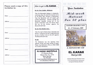
Ephemera (Item) - Information brochure, A MINISTRY OF EL KANAH Marysville, 2009
... 2009 black saturday bushfires... black saturday bushfires christian community An information ...An information brochure regarding an event that was scheduled to take place in February 2009 at El Kanah in Marysville.An information brochure regarding an event that was scheduled to take place in February 2009 at El Kanah in Marysville.marysville, victoria, australia, el kanah, accommodation, information brochure, 2009 black saturday bushfires, christian community -
 Marysville & District Historical Society
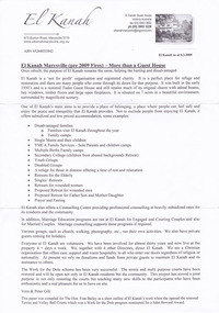
Document (Item), Vera and Peter Gill, El Kanah Marysville (pre 2009 Fires) - More than a Guest House, Unknown
... 2009 black saturday bushfires... black saturday bushfires This paper was compiled for The Hon ...A document regarding El Kanah in Marysville that outlines it's purposes. This paper was compiled for The Hon. Fran Bailey as a short outline of El Kanah's work when she opened the restored Tennis and Volley Ball Courts which was a work for the Dole program nominated for a John Howard Award.A document regarding El Kanah in Marysville that outlines it's purposes.This paper was compiled for The Hon. Fran Bailey as a short outline of El Kanah's work when she opened the restored/ Tennis and Volley Ball Courts which was a work for the Dole program nominated for a John Howard Award.marysville, victoria, australia, el kanah, accommodation, christian community, 2009 black saturday bushfires -
 Marysville & District Historical Society
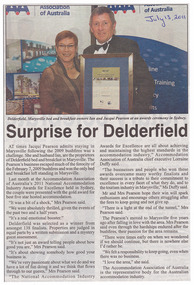
Newspaper (Item) - Newspaper article, Surprise for Delderfield, 13-07-2011
... 2009 black saturday bushfires... for excellence 2009 black saturday bushfires A newspaper article ...A newspaper article regarding the awarding of a 2011 National Accommodation Industry Awards for Excellence for Delderfield Luxury Bed & Breakfast in Marysville.A newspaper article regarding the awarding of a 2011 National Accommodation Industry Awards for Excellence for Delderfield Luxury Bed & Breakfast in Marysville.marysville, victoria, australia, delderfield luxury bed & breakfast, accommodation, national accommodation industry award for excellence, 2009 black saturday bushfires -
 Marysville & District Historical Society
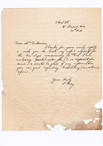
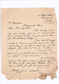
Letter (item) - Hand written letter, Mr E. Gray, 30-10-1934
... 2009 black saturday bushfires... dickinson linda dickinson 2009 black saturday bushfires letter e ...A digital copy of a hand written letter enclosing postal notes as a deposit for accommodation at Marysville House over the Christmas period in 1934. Marysville House was built in the late 1920s by Arthur Dickinson.A digital copy of a hand written letter enclosing postal notes as a deposit for accommodation at Marysville House over the Christmas period in 1934. Marysville House was built in the late 1920s by Arthur Dickinson.marysville, victoria, australia, marysville house, arthur james dickinson, grace dickinson, arnold spooner, eileen marie spooner, eileen marie dickinson, grace sweetland, eric dowdle, elsie may denton, elsie may dickinson, peter dickinson, linda dickinson, 2009 black saturday bushfires, letter, e. gray -
 Marysville & District Historical Society
Letter (item) - Hand written letter, Mrs A. Munroe, 30-10-1934
... 2009 black saturday bushfires... dickinson linda dickinson 2009 black saturday bushfires letter mrs ...A digital copy of a hand written letter enquiring on the availability and tariff of accommodation at Marysville House during Christmas in 1934. Marysville House was built in the late 1920s by Arthur Dickinson.A digital copy of a hand written letter enquiring on the availability and tariff of accommodation at Marysville House during Christmas in 1934. Marysville House was built in the late 1920s by Arthur Dickinson.marysville, victoria, australia, marysville house, arthur james dickinson, grace dickinson, arnold spooner, eileen marie spooner, eileen marie dickinson, grace sweetland, eric dowdle, elsie may denton, elsie may dickinson, peter dickinson, linda dickinson, 2009 black saturday bushfires, letter, mrs a. munroe -
 Marysville & District Historical Society
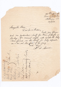
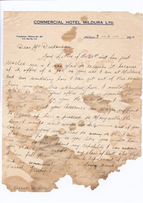
Letter (item) - Hand written letter, R. Couzens, 31-10-1934
... 2009 black saturday bushfires... dickinson linda dickinson 2009 black saturday bushfires letter r ...A digital copy of a hand written letter thanking Mrs Dickinson for providing information regarding transportation to Marysville and requesting that transport be booked. The letter also asks if Mrs Dickinson would prefer to be paid the tariff for staying at Marysville House before the guests arrive or would it be permitted for them to pay it at the time of their stay. Marysville House was built in the late 1920s by Arthur Dickinson.A digital copy of a hand written letter thanking Mrs Dickinson for providing information regarding transportation to Marysville and requesting that transport be booked. The letter also asks if Mrs Dickinson would prefer to be paid the tariff for staying at Marysville House before the guests arrive or would it be permitted for them to pay it at the time of their stay. Marysville House was built in the late 1920s by Arthur Dickinson.marysville, victoria, australia, marysville house, arthur james dickinson, grace dickinson, arnold spooner, eileen marie spooner, eileen marie dickinson, grace sweetland, eric dowdle, elsie may denton, elsie may dickinson, peter dickinson, linda dickinson, 2009 black saturday bushfires, letter, r. couzens -
 Marysville & District Historical Society
Letter (item) - Hand written letter, Jean Aitken, 02-11-1934
... 2009 black saturday bushfires... dickinson 2009 black saturday bushfires letter jean aitken A digital ...A digital copy of a hand written letter which encloses the deposit for accommodation at Marysville House as well as confirming the date of arrival of the guest. Marysville House was built in the late 1920s by Arthur Dickinson.A digital copy of a hand written letter which encloses the deposit for accommodation at Marysville House as well as confirming the date of arrival of the guest. Marysville House was built in the late 1920s by Arthur Dickinson.marysville, victoria, australia, marysville house, arthur james dickinson, grace dickinson, arnold spooner, eileen marie spooner, eileen marie dickinson, grace sweetland, eric dowdle, elsie may denton, elsie may dickinson, peter dickinson, linda dickinson, 2009 black saturday bushfires, letter, jean aitken -
 Marysville & District Historical Society
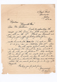
Letter (Item) - Hand written letter, R. Couzens, 06-09-1934
... 2009 black saturday bushfires... dickinson peter dickinson linda dickinson 2009 black saturday ...A digital copy of a letter to Mrs Dickinson requesting a booking be made for accommodation at Marysville House for two weeks over Christmas in 1934. Marysville House was built in the late 1920s by Arthur Dickinson.A digital copy of a letter to Mrs Dickinson requesting a booking be made for accommodation at Marysville House for two weeks over Christmas in 1934. Marysville House was built in the late 1920s by Arthur Dickinson.marysville, victoria, australia, marysville house, arthur james dickinson, grace dickinson, arnold spooner, eileen marie spooner, eileen marie dickinson, grace sweetland, eric dowdle, elsie may denton, elsie may dickinson, peter dickinson, linda dickinson, 2009 black saturday bushfires, letter, r. couzens -
 Marysville & District Historical Society
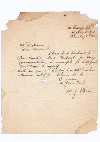
Letter (item) - Hand written letter, Mr J. Phair, 08-11-1934
... 2009 black saturday bushfires... dickinson peter dickinson linda dickinson 2009 black saturday ...A digital copy of a hand written letter enclosing a deposit for accommodation at Marysville House over the Christmas period in 1934. Marysville House was built in the late 1920s by Arthur Dickinson.A digital copy of a hand written letter enclosing a deposit for accommodation at Marysville House over the Christmas period in 1934. Marysville House was built in the late 1920s by Arthur Dickinson.marysville, victoria, australia, marysville house, arthur james dickinson, grace dickinson, arnold spooner, eileen marie spooner, eileen marie dickinson, grace sweetland, eric dowdle, elsie may denton, elsie may dickinson, peter dickinson, linda dickinson, 2009 black saturday bushfires, letter, mr j. phair -
 Marysville & District Historical Society
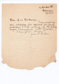
Letter (item) - Hand written letter, 03-11-1934
... 2009 black saturday bushfires... 2009 black saturday bushfires letter A digital copy of a hand ...A digital copy of a hand written letter accepting the offer of a position as a cook at Marysville House. The writer also requests an advancement of wages to enable them to settle up at their current employer and travel to Marysville. Marysville House was built in the late 1920s by Arthur Dickinson.A digital copy of a hand written letter accepting the offer of a position as a cook at Marysville House. The writer also requests an advancement of wages to enable them to settle up at their current employer and travel to Marysville. Marysville House was built in the late 1920s by Arthur Dickinson.marysville, victoria, australia, marysville house, arthur james dickinson, grace dickinson, arnold spooner, eileen marie spooner, eileen marie dickinson, grace sweetland, eric dowdle, elsie may denton, elsie may dickinson, peter dickinson, linda dickinson, 2009 black saturday bushfires, letter -
 Marysville & District Historical Society
Letter (item) - Hand written letter, Mrs A. Munroe, 10-11-1934
... 2009 black saturday bushfires... dickinson linda dickinson 2009 black saturday bushfires letter mrs ...A digital copy of a hand written letter enclosing the deposit for accommodation at Marysville House and requesting if Marysville House has provision for the guests' private car. Marysville House was built in the late 1920s by Arthur Dickinson.A digital copy of a hand written letter enclosing the deposit for accommodation at Marysville House and requesting if Marysville House has provision for the guests' private car. Marysville House was built in the late 1920s by Arthur Dickinson.marysville, victoria, australia, marysville house, arthur james dickinson, grace dickinson, arnold spooner, eileen marie spooner, eileen marie dickinson, grace sweetland, eric dowdle, elsie may denton, elsie may dickinson, peter dickinson, linda dickinson, 2009 black saturday bushfires, letter, mrs a. munroe -
 Marysville & District Historical Society
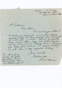
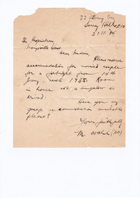
Letter (item) - Hand written letter, Mr M. Walsh, 27-11-1934
... 2009 black saturday bushfires... dickinson linda dickinson 2009 black saturday bushfires letter mr m ...A digital copy of a hand written letter requesting the availability of accommodation at Marysville for a married couple. The letter also enquires the availability of garage accommodation. Marysville House was built in the late 1920s by Arthur Dickinson.A digital copy of a hand written letter requesting the availability of accommodation at Marysville for a married couple. The letter also enquires the availability of garage accommodation. Marysville House was built in the late 1920s by Arthur Dickinson.marysville, victoria, australia, marysville house, arthur james dickinson, grace dickinson, arnold spooner, eileen marie spooner, eileen marie dickinson, grace sweetland, eric dowdle, elsie may denton, elsie may dickinson, peter dickinson, linda dickinson, 2009 black saturday bushfires, letter, mr m. walsh -
 Marysville & District Historical Society
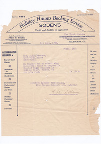
Ephemera (Item) - Invoice/Account, "Holiday Haunts" Booking Service, Holiday Haunts Booking Service, 01-12-1934
... 2009 black saturday bushfires... 2009 black saturday bushfires holiday haunts booking service ...A digital copy of an account from Holiday Haunts Booking Service to A.J. Dickinson, Esq. for deposits received in regard to accommodation bookings at Marysville House. Marysville House was built in the late 1920s by Arthur Dickinson.A digital copy of an account from Holiday Haunts Booking Service to A.J. Dickinson, Esq. for deposits received in regard to accommodation bookings at Marysville House. Marysville House was built in the late 1920s by Arthur Dickinson.marysville, victoria, australia, marysville house, arthur james dickinson, grace dickinson, arnold spooner, eileen marie spooner, eileen marie dickinson, grace sweetland, eric dowdle, elsie may denton, elsie may dickinson, peter dickinson, linda dickinson, 2009 black saturday bushfires, holiday haunts booking service, invoice, account -
Marysville & District Historical Society
Document (item) - Information document, Judith Vimpani, Maria & Ern McIntyre at Moondai Farm B&B, 05-2021
... 2009 black saturday bushfires... moondai farm b&b maria mcintyre ern mcintyre 2009 black saturday ...A document outlining the recent history of Moondai Farm B&B near Marysville.A document outlining the recent history of Moondai Farm B&B near Marysville.marysville, victoria, australia, moondai farm b&b, maria mcintyre, ern mcintyre, 2009 black saturday bushfires -
 Marysville & District Historical Society
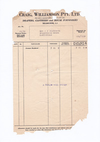
Ephemera (Item) - Invoice, Craig, Williamson Pty. Ltd, 08-1934
... 2009 black saturday bushfires... dickinson peter dickinson linda dickinson 2009 black saturday ...A digital copy of an invoice from Craig, Williamson Pty. Ltd. to Mrs A.J. Dickinson of Marysville House requesting payment for goods received in August 1934. Marysville House was built by Arthur Dickinson in the late 1920s.A digital copy of an invoice from Craig, Williamson Pty. Ltd. to Mrs A.J. Dickinson of Marysville House requesting payment for goods received in August 1934. Marysville House was built by Arthur Dickinson in the late 1920s.marysville, victoria, australia, marysville house, arthur james dickinson, grace dickinson, arnold spooner, eileen marie spooner, eileen marie dickinson, grace sweetland, eric dowdle, elsie may denton, elsie may dickinson, peter dickinson, linda dickinson, 2009 black saturday bushfires, invoice, craig williamson pty ltd -
 Marysville & District Historical Society
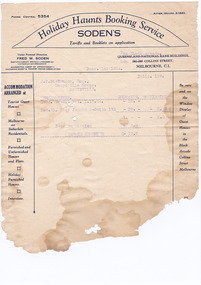
Ephemera (Item) - Receipt, "Holiday Haunts" Booking Service, 14-08-1934
... 2009 black saturday bushfires... dickinson peter dickinson linda dickinson 2009 black saturday ...A digital copy of a receipt for a deposit paid for accommodation at Marysville House. The deposit was taken by Holiday Haunts Booking Service in Melbourne. Marysville House was built in the late 1920s by Arthur Dickinson.A digital copy of a receipt for a deposit paid for accommodation at Marysville House. The deposit was taken by Holiday Haunts Booking Service in Melbourne. Marysville House was built in the late 1920s by Arthur Dickinson.marysville, victoria, australia, marysville house, arthur james dickinson, grace dickinson, arnold spooner, eileen marie spooner, eileen marie dickinson, grace sweetland, eric dowdle, elsie may denton, elsie may dickinson, peter dickinson, linda dickinson, 2009 black saturday bushfires, receipt, holiday haunts booking service -
 Marysville & District Historical Society
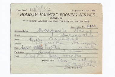
Ephemera (Item) - Receipt, "Holiday Haunts" Booking Service, Holiday Haunts Booking Service, 01-09-1934
... 2009 black saturday bushfires... dickinson linda dickinson 2009 black saturday bushfires receipt ...A digital copy of a receipt for payment of an account to Holiday Haunts Booking Service from Mrs A.J. Dickinson from Marysville House. Marysville House was built in the late 1920s by Arthur Dickinson.A digital copy of a receipt for payment of an account to Holiday Haunts Booking Service from Mrs A.J. Dickinson from Marysville House. Marysville House was built in the late 1920s by Arthur Dickinson.marysville, victoria, australia, marysville house, arthur james dickinson, grace dickinson, arnold spooner, eileen marie spooner, eileen marie dickinson, grace sweetland, eric dowdle, elsie may denton, elsie may dickinson, peter dickinson, linda dickinson, 2009 black saturday bushfires, receipt, holiday haunts booking service