Showing 1440 items
matching black photo album
-
 Eltham District Historical Society Inc
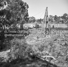
Negative - Photograph, J.A. McDonald, Laidlays Road, Arthurs Creek, April 1962
Bridge over Arthurs Creek Looking east April 1962Record of various Shire of Eltham infrastructure works undertaken during the period of 1952-1962 involving bridge and road reconstruction projects, sometimes with Eltham Shire Council Project Reference numbers quoted. It was during this period that a number of significant improvements were made to roads and new bridges constructed within the shire that remain in place as of present day (2022). In many situations, the photos provide a tangible visible record of infrastructure that existed throughout the early days of the Shire. The album was put together by or under the direction of the Shire Engineer, J.A. McDonald.1962-04, arthurs creek, bridge construction, infrastructure, laidlays road, shire of eltham -
 Eltham District Historical Society Inc
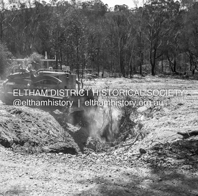
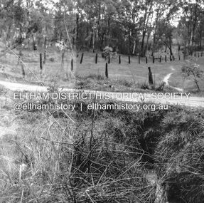
Negative - Photograph, J.A. McDonald, Buttermans Track, St Andrews, April 1962
LR Bassett P/L filling in scour on Crosby's property Circa April 1962Record of various Shire of Eltham infrastructure works undertaken during the period of 1952-1962 involving bridge and road reconstruction projects, sometimes with Eltham Shire Council Project Reference numbers quoted. It was during this period that a number of significant improvements were made to roads and new bridges constructed within the shire that remain in place as of present day (2022). In many situations, the photos provide a tangible visible record of infrastructure that existed throughout the early days of the Shire. The album was put together by or under the direction of the Shire Engineer, J.A. McDonald.1962-04, bridge construction, buttermans track, flood damage, infrastructure, shire of eltham, st andrews -
 Eltham District Historical Society Inc
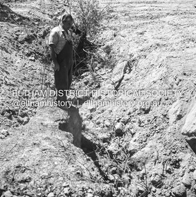
Negative - Photograph, J.A. McDonald, Buttermans Track, St Andrews, April 1962
Looking downstream from culvert to Fillia (?) property Circa April 1962Record of various Shire of Eltham infrastructure works undertaken during the period of 1952-1962 involving bridge and road reconstruction projects, sometimes with Eltham Shire Council Project Reference numbers quoted. It was during this period that a number of significant improvements were made to roads and new bridges constructed within the shire that remain in place as of present day (2022). In many situations, the photos provide a tangible visible record of infrastructure that existed throughout the early days of the Shire. The album was put together by or under the direction of the Shire Engineer, J.A. McDonald.1962-04, buttermans track, infrastructure, shire of eltham, st andrews, bridge construction -
 Eltham District Historical Society Inc
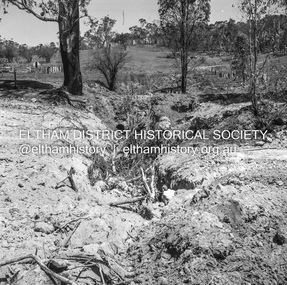
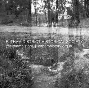
Negative - Photograph, J.A. McDonald, Buttermans Track, St Andrews, April 1962
Looking to culvert from Crosby's boundary Circa April 1962Record of various Shire of Eltham infrastructure works undertaken during the period of 1952-1962 involving bridge and road reconstruction projects, sometimes with Eltham Shire Council Project Reference numbers quoted. It was during this period that a number of significant improvements were made to roads and new bridges constructed within the shire that remain in place as of present day (2022). In many situations, the photos provide a tangible visible record of infrastructure that existed throughout the early days of the Shire. The album was put together by or under the direction of the Shire Engineer, J.A. McDonald.1962-04, buttermans track, infrastructure, shire of eltham, st andrews, bridge construction -
 Eltham District Historical Society Inc
Negative - Photograph, J.A. McDonald, Buttermans Track, St Andrews, April 1962
Culvert which discharges onto Crosby's land Circa April 1962Record of various Shire of Eltham infrastructure works undertaken during the period of 1952-1962 involving bridge and road reconstruction projects, sometimes with Eltham Shire Council Project Reference numbers quoted. It was during this period that a number of significant improvements were made to roads and new bridges constructed within the shire that remain in place as of present day (2022). In many situations, the photos provide a tangible visible record of infrastructure that existed throughout the early days of the Shire. The album was put together by or under the direction of the Shire Engineer, J.A. McDonald.1962-04, buttermans track, infrastructure, shire of eltham, st andrews, bridge construction -
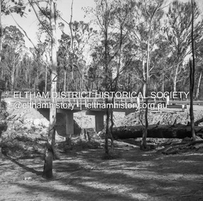 Eltham District Historical Society Inc
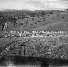
Negative - Photograph, J.A. McDonald, Henley Road Bridge at Watsons Creek, c. May 1962
Completed early January 1962Record of various Shire of Eltham infrastructure works undertaken during the period of 1952-1962 involving bridge and road reconstruction projects, sometimes with Eltham Shire Council Project Reference numbers quoted. It was during this period that a number of significant improvements were made to roads and new bridges constructed within the shire that remain in place as of present day (2022). In many situations, the photos provide a tangible visible record of infrastructure that existed throughout the early days of the Shire. The album was put together by or under the direction of the Shire Engineer, J.A. McDonald.1962-05, bend of islands, bridge construction, henley road, henley road bridge, infrastructure, kangaroo ground, oxley bridge, road construction, shire of eltham, watsons creek -
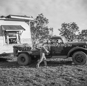 Eltham District Historical Society Inc
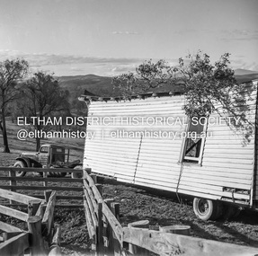
Negative - Photograph, J.A. McDonald, Removal of the remains of the Abraham house at Kangaroo Ground, c. May 1962
Martin Bros House Removing of Seaford was contracted to remove the remains of the storm damaged Abraham house from the property circa May 1962. The Abraham family owned land near the Aqueduct and east of Nicholas Lane at Kangaroo Ground (based on photos, at or near 40 Nicholas Lane).Record of various Shire of Eltham infrastructure works undertaken during the period of 1952-1962 involving bridge and road reconstruction projects, sometimes with Eltham Shire Council Project Reference numbers quoted. It was during this period that a number of significant improvements were made to roads and new bridges constructed within the shire that remain in place as of present day (2022). In many situations, the photos provide a tangible visible record of infrastructure that existed throughout the early days of the Shire. The album was put together by or under the direction of the Shire Engineer, J.A. McDonald.1962-05, abraham house, kangaroo ground, martin bros house removing seaford, nicholas lane, property damage -
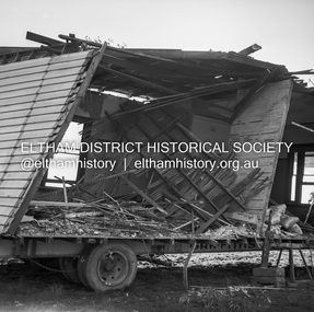
 Eltham District Historical Society Inc
Negative - Photograph, J.A. McDonald, Removal of the remains of the Abraham house at Kangaroo Ground, c. May 1962
Martin Bros House Removing of Seaford was contracted to remove the remains of the storm damaged Abraham house from the property circa May 1962. The Abraham family owned land near the Aqueduct and east of Nicholas Lane at Kangaroo Ground (based on photos, at or near 40 Nicholas Lane).Record of various Shire of Eltham infrastructure works undertaken during the period of 1952-1962 involving bridge and road reconstruction projects, sometimes with Eltham Shire Council Project Reference numbers quoted. It was during this period that a number of significant improvements were made to roads and new bridges constructed within the shire that remain in place as of present day (2022). In many situations, the photos provide a tangible visible record of infrastructure that existed throughout the early days of the Shire. The album was put together by or under the direction of the Shire Engineer, J.A. McDonald.1962-05, abraham house, kangaroo ground, martin bros house removing seaford, nicholas lane, property damage -
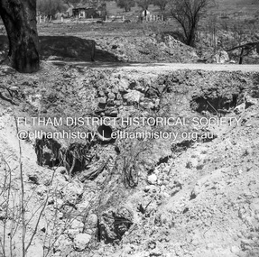
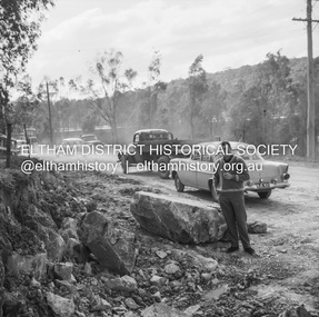
 Eltham District Historical Society Inc
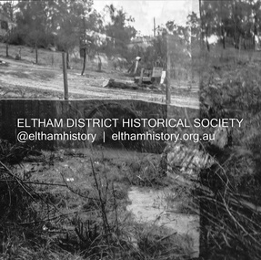
Negative - Photograph, J.A. McDonald, Fordhams Road, Eltham, 24 July 1962
Culvert discharging towards land owned by Holloway & Spicer about 3pm on 24 July 1962 Heavy rain 60 years later it still appears to present as a concern - see Google Street View (Nov 2021) https://goo.gl/maps/x61yWvAc5UjJ2d8y9Record of various Shire of Eltham infrastructure works undertaken during the period of 1952-1962 involving bridge and road reconstruction projects, sometimes with Eltham Shire Council Project Reference numbers quoted. It was during this period that a number of significant improvements were made to roads and new bridges constructed within the shire that remain in place as of present day (2022). In many situations, the photos provide a tangible visible record of infrastructure that existed throughout the early days of the Shire. The album was put together by or under the direction of the Shire Engineer, J.A. McDonald.1962-07-24, culvert, eltham, fordhams road, infrastructure, shire of eltham -
 Eltham District Historical Society Inc
Negative - Photograph, J.A. McDonald, Fordhams Road, Eltham, 24 July 1962
Culvert discharging towards land owned by Holloway & Spicer about 3pm on 24 July 1962 Heavy rainRecord of various Shire of Eltham infrastructure works undertaken during the period of 1952-1962 involving bridge and road reconstruction projects, sometimes with Eltham Shire Council Project Reference numbers quoted. It was during this period that a number of significant improvements were made to roads and new bridges constructed within the shire that remain in place as of present day (2022). In many situations, the photos provide a tangible visible record of infrastructure that existed throughout the early days of the Shire. The album was put together by or under the direction of the Shire Engineer, J.A. McDonald.1962-07-24, culvert, eltham, fordhams road, infrastructure, shire of eltham -
 Eltham District Historical Society Inc
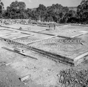
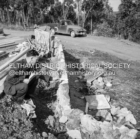
Negative - Photograph, J.A. McDonald, Building site inspection by Eltham Shire Council Building Surveyor, George Newton, c. July 1962
Record of various Shire of Eltham infrastructure works undertaken during the period of 1952-1962 involving bridge and road reconstruction projects, sometimes with Eltham Shire Council Project Reference numbers quoted. It was during this period that a number of significant improvements were made to roads and new bridges constructed within the shire that remain in place as of present day (2022). In many situations, the photos provide a tangible visible record of infrastructure that existed throughout the early days of the Shire. The album was put together by or under the direction of the Shire Engineer, J.A. McDonald.1962-07, building site, building surveyor, george e. newton, houses, eltham shire council -
 Eltham District Historical Society Inc
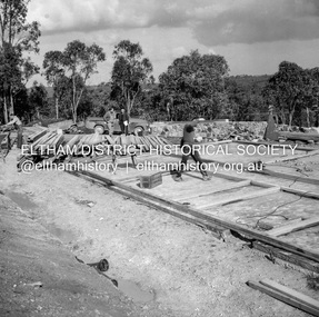
Negative - Photograph, J.A. McDonald, Road reconstruction works, unidentified location, Shire of Eltham, c. July 1962
Record of various Shire of Eltham infrastructure works undertaken during the period of 1952-1962 involving bridge and road reconstruction projects, sometimes with Eltham Shire Council Project Reference numbers quoted. It was during this period that a number of significant improvements were made to roads and new bridges constructed within the shire that remain in place as of present day (2022). In many situations, the photos provide a tangible visible record of infrastructure that existed throughout the early days of the Shire. The album was put together by or under the direction of the Shire Engineer, J.A. McDonald.1962-07, infrastructure, reconstruction works, road construction, shire of eltham, tip-top bread, unidentified -
 Eltham District Historical Society Inc
Negative - Photograph, J.A. McDonald, Road reconstruction works, unidentified location, Shire of Eltham, c. July 1962
Record of various Shire of Eltham infrastructure works undertaken during the period of 1952-1962 involving bridge and road reconstruction projects, sometimes with Eltham Shire Council Project Reference numbers quoted. It was during this period that a number of significant improvements were made to roads and new bridges constructed within the shire that remain in place as of present day (2022). In many situations, the photos provide a tangible visible record of infrastructure that existed throughout the early days of the Shire. The album was put together by or under the direction of the Shire Engineer, J.A. McDonald.1962-07, infrastructure, reconstruction works, road construction, shire of eltham, unidentified -
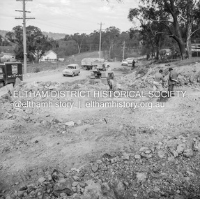
 Eltham District Historical Society Inc
Negative - Photograph, J.A. McDonald, Sherbourne Road, Montmorency, c. July 1962
View looking west across Sherbourne Road to intersection of Rattray Road from present-day forecourt entrance to 7-Eleven Eltham service station The BP Service Station is now an Ampol Service Station (2022) Google Street View Apr.. 2022 https://goo.gl/maps/LM4APKCwj1ohBDPv5Record of various Shire of Eltham infrastructure works undertaken during the period of 1952-1962 involving bridge and road reconstruction projects, sometimes with Eltham Shire Council Project Reference numbers quoted. It was during this period that a number of significant improvements were made to roads and new bridges constructed within the shire that remain in place as of present day (2022). In many situations, the photos provide a tangible visible record of infrastructure that existed throughout the early days of the Shire. The album was put together by or under the direction of the Shire Engineer, J.A. McDonald.1962-07, ampol service station, bp service station, montmorency, rattray road, service station, sherbourne road, graders, infrastructure, public telephone box (red), reconstruction works, road construction, shire of eltham -
 Eltham District Historical Society Inc
Negative - Photograph, J.A. McDonald, Sherbourne Road, Montmorency, c. July 1962
View looking west across Sherbourne Road to intersection of Rattray Road from present-day forecourt entrance to 7-Eleven Eltham service station The BP Service Station is now an Ampol Service Station (2022) Google Street View Apr.. 2022 https://goo.gl/maps/LM4APKCwj1ohBDPv5Record of various Shire of Eltham infrastructure works undertaken during the period of 1952-1962 involving bridge and road reconstruction projects, sometimes with Eltham Shire Council Project Reference numbers quoted. It was during this period that a number of significant improvements were made to roads and new bridges constructed within the shire that remain in place as of present day (2022). In many situations, the photos provide a tangible visible record of infrastructure that existed throughout the early days of the Shire. The album was put together by or under the direction of the Shire Engineer, J.A. McDonald.1962-07, ampol service station, bp service station, montmorency, rattray road, service station, sherbourne road, infrastructure, reconstruction works, road construction, shire of eltham -
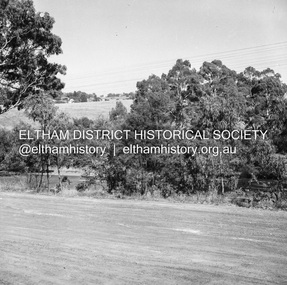 Eltham District Historical Society Inc
Negative - Photograph, J.A. McDonald, Eltham-Yarra Glen Road, Lower Plenty, c. July 1962
View looking west across Old Eltham Road to the Eltham-Yarra Glen RoadRecord of various Shire of Eltham infrastructure works undertaken during the period of 1952-1962 involving bridge and road reconstruction projects, sometimes with Eltham Shire Council Project Reference numbers quoted. It was during this period that a number of significant improvements were made to roads and new bridges constructed within the shire that remain in place as of present day (2022). In many situations, the photos provide a tangible visible record of infrastructure that existed throughout the early days of the Shire. The album was put together by or under the direction of the Shire Engineer, J.A. McDonald.1962-07, eltham-yarra glen road, infrastructure, lower plenty, lower plenty road, road construction, shire of eltham, old eltham road -
 Eltham District Historical Society Inc
Negative - Photograph, J.A. McDonald, Eltham-Yarra Glen Road, Lower Plenty, c. July 1962
View looking west across the Eltham-Yarra Glen Road approaching the Lower Plenty Bridge near turn-off for the Golf Club Hotel. Present-day Lower Plenty Road follows a revised alignment across a new bridge. The former bridge is now part of the Plenty River Trail and Edward Willis Court now follows this section of the original Eltham-Yarra Glen Road.. The Golf Club Hotel is gone and a new Lower Plenty Hotel was built slightly further up the hill.Record of various Shire of Eltham infrastructure works undertaken during the period of 1952-1962 involving bridge and road reconstruction projects, sometimes with Eltham Shire Council Project Reference numbers quoted. It was during this period that a number of significant improvements were made to roads and new bridges constructed within the shire that remain in place as of present day (2022). In many situations, the photos provide a tangible visible record of infrastructure that existed throughout the early days of the Shire. The album was put together by or under the direction of the Shire Engineer, J.A. McDonald.1962-07, shire of eltham, old eltham road, edward willis court, eltham-yarra glen road, golf club hotel, infrastructure, lower plenty, road construction -
 Eltham District Historical Society Inc
Negative - Photograph, J.A. McDonald, Old house, Susan Street, Eltham, c. 1962
Williams house, Susan StreetRecord of various Shire of Eltham infrastructure works undertaken during the period of 1952-1962 involving bridge and road reconstruction projects, sometimes with Eltham Shire Council Project Reference numbers quoted. It was during this period that a number of significant improvements were made to roads and new bridges constructed within the shire that remain in place as of present day (2022). In many situations, the photos provide a tangible visible record of infrastructure that existed throughout the early days of the Shire. The album was put together by or under the direction of the Shire Engineer, J.A. McDonald.eltham, houses, susan street, williams house -
 Eltham District Historical Society Inc
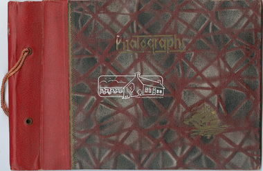
Album - Photograph Album, Alan Gardner, Engineering Infrastructure Projects, 1939-1942
alan gardner collection -
 Eltham District Historical Society Inc
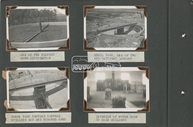
Album - Photograph Album, Alan Gardiner, M.M.B.W Braeside Sewage Treatment Plant Construction, 1939
In April 1928 the MMBW had the land and the plans for what they were to construct but the timing of the actual building did not proceed as planned. Before the construction could commence the Great Depression of the 1930s intervened forcing the shelving of its plans. The new owners then offered the land for lease resulting in Frederick Werrett taking the opportunity to take up the land he formerly owned to continue his market gardening activities of growing potatoes, onions and other crops. The land and improvements made by Syme were leased in 1929 to Harry Telford a trainer from New South Wales. Phar Lap grazed there for a short time. [9] However the population of Melbourne continued to grow and the need for a sewerage treatment plant did not go away. In 1939 when the effects of the Depression had dissipated work on the Sewerage Effluent Treatment Plant commenced and the following year in October the Premier of the State, Albert Dunstan, officially commissioned it. The Sewerage Effluent Treatment Plant at Braeside served the communities of south-east Melbourne for thirty five years until 1975. In that year all the sewers that entered the Braeside plant were diverted to the South Eastern Trunk Sewer complex at Carrum.[10] In 1982 the chairman of the MMBW at that time, Alan Croxford, announced that a substantial part of the property at Braeside would be administered by the Parks and Gardens section of MMBW as a public park. Subsequently the responsibilities were transferred to Parks Victoria, the situation that exists today. It is known as “Braeside Park” now. [Source: Sewerage Treatment Plant at Braeside, Kingston Local History, https://localhistory.kingston.vic.gov.au/articles/407]alan gardiner collection, 1939, braeside sewage treatment plant, construction, melbourne metropolitan board of works, mmbw -
 Eltham District Historical Society Inc
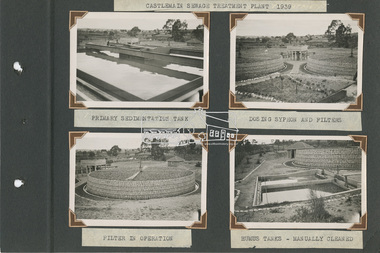
Album - Photograph Album, Alan Gardiner, Castlemaine Sewage Treatment Plant, 1939
Ialan gardiner collection, 1939, construction, castlemaine sewage treatment plant -
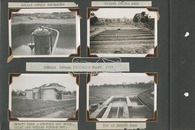 Eltham District Historical Society Inc
Album - Photograph Album, Alan Gardiner, Castlemaine and Kerang Sewage Treatment Plants, 1939
Ialan gardiner collection, 1939, construction, castlemaine sewage treatment plant, kerang sewage treatment plant