Showing 8318 items
matching bridging
-
 Halls Gap & Grampians Historical Society
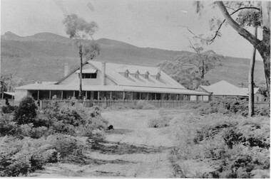
Photograph - Sepia
Myrtlebank before bridgeGuest House before bridge Appears to be taken from post card photoThe rose Series P 4971accommodation, guesthouses, myrtlebank -
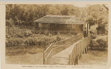 Phillip Island and District Historical Society Inc.
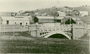
Photograph - Post Card, 1920
Donated by Stan McFee from the Keith McIlwraith Collection.Black & White Postcard of rustic bridge leading to Teahouse where a figure stands behind teatree staked fence. Surrounded by trees and shrubs."Rustic bridge at the Tea House. Cowes, Phillip Island." "Valentines Series M. 4851"tea house phillip island, cowes, phillip island, stan mcfee, keith mcilwraith collection -
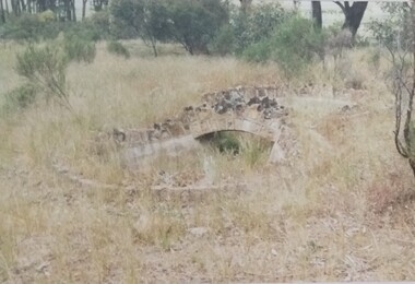 Tatura Irrigation & Wartime Camps Museum
Photograph, Arthur Knee, Camp 13 stone bridge, 1989
Camp 13, administration area, s.w. corner near Commandants house. Made by prisoners using local stone.Camp 13, Camp Road, Murchison, Victoria. Stone work,ornamental pond, bridge, s.w. corner near administration area - remnants.Camp 13 West Garrison Gardens - Stone bridge over figure 8 poolcamp 13, murchison victoria, pow, internment camps, stonework -
 Glenelg Shire Council Cultural Collection
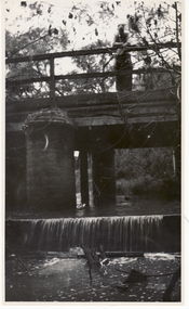
Photograph - Photograph - Near Glenelg Bridge Dartmoor, c. 1946
SOURCED FROM CASTERTON TOWN HALL (FORMER SHIRE OF GLENELG) Sourced from Casterton Town Hall (Former Shire of Glenelg)Black and white photo, showing fences near Glenelg Bridge at ? Dartmoor, after a flood, possible the one of 1946Back: 'Fences near Glenelg Bridge, D......' handwritten in pencil 'GB 4242 ' pencil, stamp '57' -
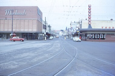 Ballarat Tramway Museum
Slide - 35mm slide/s, Feb. 1963
View looking down Bridge St. from east end of Sturt St. Photographer standing before junction of tracks, looking east. No trams in photo, two or three cars on the roads. With Morseheads and Dickins stores on the corner.'Ballarat Feb. 1963, Bridge St in blue inktramways, trams, bridge st., grenville st -
 Greensborough Historical Society
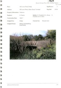
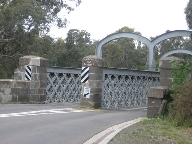
Document - Document Collection, Allom Lovell & Associates, Old Lower Plenty Bridge, 2001
Heritage citation for the Old Lower Plenty Bridge, copied from Banyule Heritage Places Study; a short history of the bridge and a news clipping, dated 2001 reporting on the re-opening of the bridge as a link in the Plenty River Trail.4 p., illus. Heritage citation, 2p.; history of bridge, 1p.; newspaper clipping, 1p. plenty river, plenty river trail, old lower plenty bridge, lower plenty -
 Ballarat Heritage Services
Photograph, Redesdale Bridge, 2016, 18/01/2016
The Redesdale Bridge is a wrought iron and timber structure with bluestone abutments which was installed over the Campaspe River in January 1868, although the bridge actually bears the date 1867. In 1859, the "Herald of the Morning", a ship carrying a cargo including 350 tons of ironwork for the Hawthorn bridge, caught fire and was scuttled a quarter of a mile off the jetty at Sandridge. A Melbourne salvaging firm raised the ironwork from the bottom of the bay, but after details of an arranged sale to the government caused a scandal in Parliament, the material was sold privately to the Melbourne foundry Langlands & Co. Two hundred tons of it was sold to the goldfields shires of McIvor and Metcalfe for only £1000. The bridge was designed by engineer T.B. Muntz and built by a contractor named Doran, and was completed late and considerably over budget at £6274. The bridge spans 45.7m across the river and has two roadways which are carried between three metal lattice girders in a through truss configuration. The design for the Hawthorn bridge had the deck supported over the trusses, and to stiffen the through truss configuration three sets of distinctive paired arches connect the trusses above the roadways. The roadway decking is constructed of longitudinally placed timbers on timber cross girders which rest on the lower chords of the trusses. (Heritage Victoria) A number of colour photographs showing the historic bridge at Metcalfe.metcalfe, shire of metcalfe, bridge, municipal boundary, shire of mcivor, redesdale bridge, campaspe river, t.b. muntz, doran -
 Orbost & District Historical Society
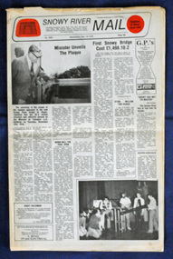
newspaper, Snowy River Mail, 1.12.1976
In early 1974, as an Engineer with the Country Roads Board, David came to Orbost as the Supervising Engineer for the construction of the new bridges which were part of an 8.4km Orbost bypass road design. This was a major project involving not only a new bridge over the Snowy River (including Lochiel Lagoon), but other bridges over Ashby’s Gulch and Watt’s Gulch. These new bridges were opened in November 1976 with the unveiling of a plaque on the eastern end of the $2.4M Snowy River Bridge. The new bridge, built by the CRB at a cost of $2.4 million, is 1.6 metres above the record flood levels of 1971. (ref. May Leatch) This newspaper contains contemporary reports of a significant event in Orbost.A Snowy River Mail newspaper, dated 1.12.1976. It contains news articles, photographs and advertisements. The main article relates to the official opening of the Snowy River Bridge and the unveiling of a plaque on the eastern approach. It also contains a history of the first Snowy River Bridge.snowy-river-bridge orbost-bridges snowy-river-mail -
Phillip Island and District Historical Society Inc.
Photograph
Phillip Island Suspension Bridge built 1938 at a cost of approx. $50,000. Part of an album compiled and donated by Mrs Helen Jansson..The first Phillip Island Suspension Bridge 1938.Descriptive caption adjoining this photo print, also the one followinglocal history, photography, photographs, slides, film, civil engineering, bridges, phillip island bridge, black & white photograph, mrs helen jansson, suspension bridges, first phillip island bridge to san remo -
 Stawell Historical Society Inc
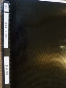
Book, M. Prior nee Morgan, Dadswells Bridge - Previously Cat No 3641, 1991
Contains excerpts from Horsham papers, concerning Dadwells Bridge from the 1860's to 1985?Black covered folder, Handwritten pages in plastic sleeves. Information is from Horsham Papers.on Spine white labels Dadswells Bridge By Mil Priorstawell -
 Whitehorse Historical Society Inc.
Photograph, Lake Road Bridge Blackburn, 1962
The old bridge demolished in 1965. Photo shows John Henster and daughter standing , looking over the side.Black and white photo of bridge, Lake Road, Blackburnlake road blackburn, lake road bridge blackburn -
 Greensborough Historical Society
Photograph - Digital image, Charles Marshall et al, Railway bridge at Tel-el-Fara, 1917_
This photograph shows a railway bridge in Tel-el-Fara, PalestineDigital copy of black and white photograph. "Railway bridge over Waddi buzzetti [?] Tel-el Fara"charles marshall, world war 1 -
 Kew Historical Society Inc
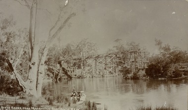
Postcard, River Yarra near Macauleys' Boathouse Kew
Sepia postcard of the Zig-zaf Bridge joining Yarra Bend and Studley Park. In the foreground is a rowboat in which a man is standing, behind whom are two women in hats and a young child. The man appears to be pushing the boat away from the Bank. In the distance is the wooden Zig-Zag Bridge, constructed in the 1870s to link the Yarra Bend and Kew Lunatic Asylums. [Destroyed by flood, 1929.]Obverse: "River Yarra near Macauleys' Boathouse Kew". Reverse: "Zig Zag Bridge / Gift from L Bennett 1980 / Bridge between Old Asylum & new Mental Hosp. / Kew side"zig-zag bridge -- kew (vic.), bridges -- river yarra, bridges -- kew (vic.) -
 Charlton Golden Grains Museum Inc
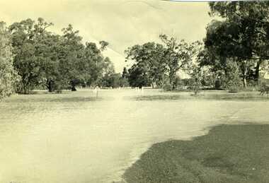
Photograph, Charlton Tribune, 1973 flood at low water bridge
1973 Flood at Charlton, Vic. At the low water bridge.Unframed photograph/ sepia of 1973 flooding of Charlton at low water bridge.flood, low water bridge -
 Kew Historical Society Inc
Photograph, J F C Farquhar, Railway Bridge Over the Yarra, 1891
At the beginning of the 1890s, the Kew businessman and Town Councillor, Henry Kellett, commissioned J.F.C. Farquhar to photograph scenes of Kew. These scenes included panoramas as well as pastoral scenes. The resulting set of twelve photographs was assembled in an album, Kew Where We Live, from which customers could select images for purchase.The preamble to the album describes that the photographs used the ‘argentic bromide’ process, now more commonly known as the gelatine silver process. This form of dry plate photography allowed for the negatives to be kept for weeks before processing, hence its value in landscape photography. The resulting images were considered to be finely grained and everlasting. Evidence of the success of Henry Kellett’s venture can be seen today, in that some of the photographs are held in national collections.It is believed that the Kew Historical Society’s copy of the Kellett album is unique and that the photographs in the book were the first copies taken from the original plates. It is the first and most important series of images produced about Kew. The individual images have proved essential in identifying buildings and places of heritage value in the district.Completed in November 1890, the railway viaduct (now the Chandler Highway Bridge) linked Kew and Fairfield. The viaduct is significant as the most substantial extant engineering remnant of the Outer Circle Railway Line. Opened in March 1891, the viaduct crossed the Yarra River in a single span, atop three supporting brick pillars. Following the closure of the railway line in 1927, and the construction of the Chandler Highway in 1930, the bridge was used for vehicular traffic. In 1891 when this panoramic photograph was taken, the grounds of what was then the Kew Lunatic Asylum extended down to the River and eastward beyond the viaduct. The landscape surrounding the Asylum was planted with traditional exotic trees such as Oaks, Pines and Cedars, and landmark trees from northern Australia such as the Hoop Pine. Remnant indigenous trees such as the River Red Gum, Yellow Box and Lightwood were scattered around the site, including beside the Yarra River.Railway Bridge Over the Yarrakew illustrated, kew where we live, photographic books, henry kellett, railway viaduct - - kew (vic) -
 Phillip Island and District Historical Society Inc.
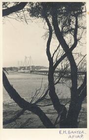
Photograph, 1941
Donated by John JanssonBlack & White Photograph. Tree dominant in foreground, bridge stretching to Newhaven in background. Photos 139-03 & -04 are identical so not listed separately."E. H. Baxter, A.F.I.A.P." On Back: "San Remo - Newhaven Bridge Phillip Island"phillip island bridge, e. h. baxter, john jansson -
 Lakes Entrance Historical Society
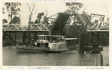
Postcard - P.S. Tanjil, Vogt, Stanley, 1920 c
Two copies existBlack and white postcard showing P S Tanjil passing downstream under Swan Reach Bridge on Tambo River, East Gippsland, Victoria.Paddle Steamer Tanjil Tambo River Swan Reach Bridge. S. Vogt Bairnsdaleships and shipping, waterways, bridges -
Phillip Island and District Historical Society Inc.
Photograph
Phillip Island Suspension Bridge built 1938/40, demolished 1970. 1st road connection with mainland at San Remo. Part of an album compiled and donated by Mrs Helen Jansson.Print of Phillip Island Suspension Bridge.local history, photography, photographs, slides, film, civil engineering, bridges, phillip island suspension bridge, black & white photograph, mrs. helen jansson, suspension bridges, phillip island -
Glenelg Shire Council Cultural Collection
Photograph - Photograph - Canal Bridge Construction, n.d
Port of Portland Authority ArchivesFront: Back- '1958 Cliff street bridge' - top left, black biro. Purple csiro stampport of portland archives -
 Orbost & District Historical Society
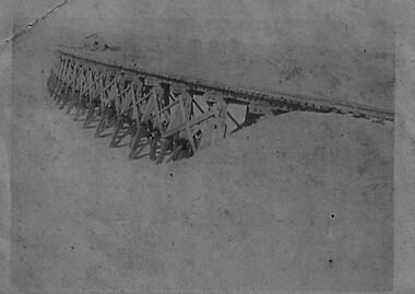
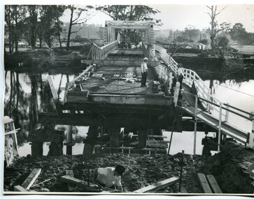
black and white photographs, February 17 1971
After the damage from the February 1971 floods at Orbost when the abutment to the Snowy River road bridge was washed away a Bailey bridge, portable, pre-fabricated, truss bridge, was put into place to ensure town access, the C.R.B. rebuilt the approach to the bridge driving new piles and constructing the Bailey bridge. They worked late into the night under flood lights to ensure the link from the Orbost township to the Princes Freeway would be open to traffic as soon as possible.These photographs are pictorial records of a significant event in the history of Orbost.Three black / white photographs of a Bailey bridge being erected across a river. 3245.1 and 3245.2 are the same. bailey-bridge orbost-snowy-river-bridge bridge-orbost -
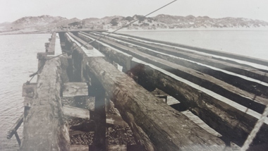
Phillip Island and District Historical Society Inc.
Photograph, 1968
Part of an album compiled and donated by Mrs Helen Jansson. Construction of second bridge (1968/9) connecting Phillip Island and San Remo, which replaced first Suspension Bridge built in 1938/40.Initial construction of second Bridge, 1968. Close up of foundations forming for Pylon.local history, photography, photographs, slides, film, civil engineering, bridges, phillip island bridges, black & white photograph, mrs helen jansson, phillip island bridge -
 Melton City Libraries
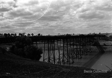
Photograph, Melton Viaduct, 1976
The Melton Viaduct, opened in 1886, is one of Australia’s largest early metal bridges. When opened it was the second longest Australian metal truss bridge, after the 1862 Moorabool railway viaduct (396 metres).The Melton Viaduct is a trestle bridge over the Werribee River (now Melton Reservoir)transport -
 Clunes Museum
Photograph
PHOTOGRAPH OF GOVERNMENT BRIDGE OVER CRESWICK CREEK ON CRESWICK ROAD, CLUNES. PHOTOGRAPH DONATED BY CRESWICK MUSEUM. COPIED BY MR. SEMMENS FROM AN EARLIER PHOTOGRAPH.BLACK AND WHITE PHOTOGRAPH OF BRIDGE OVER CRESWICK CREEK AT CLUNES - GOVERNMENT BRIDGE, CRESWICK ROAD. EBERHARDS SOFT DRINK FACTORY IN CENTRE OF PHOTOGRAPH.local history, photography, photographs -
 Phillip Island and District Historical Society Inc.
Newspaper clippings, 14/04/1938
Article on need for a bridge linking Phillip Island and the Mainland - published in Sun News Pictorial on 14/4/1938Article on the need for a bridge linking Newhaven and San Remolocal history, documents, newspapers, bridges, phillip island, black & white newspaper clipping, bridge phillip island & san remo -
 Peterborough History Group
Photograph - Bridge Construction 1927
The bridge over the Curdies River was constructed using funds raised by the Peterborough residents. The bridge was important to allow ease of access rather than having to cross using a boat.Bridge provided important access to the area.Series of 9 photographs showing the progress of the construction of the bridge over the Curdies River in 1927Several of the photographs have handwritten dates, from June 1927 to November 1927curdies river, curdie river bridge, peterborough, great ocean road, bridge construction -
 Marysville & District Historical Society
Booklet - Information booklet, Ann Thomas, Wilks Creek Bridge, 1993
A history of the Wilks Creek Bridge and its connection to the Yarra Track.Paperback. Front cover has an old photograph of the Wilks Creek Bridge.non-fictionA history of the Wilks Creek Bridge and its connection to the Yarra Track.wilks creek bridge, yarra track, narbethong, marysville, victoria, clement wilks, wood's point goldfields, jordan goldfields, john monash, monash and anderson, 2009 black saturday bushfires -
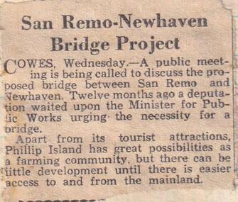 Phillip Island and District Historical Society Inc.
Newspaper clippings
Article on public meeting about proposed bridge between San Remo and Phillip Island.Article on proposed bridge between San Remo and Phillip Island.local history, documents, newspapers, bridges, phillip island, black & white newspaper clipping, bridge phillip island & san remo -
 Hume City Civic Collection
Photograph, Early 1970s
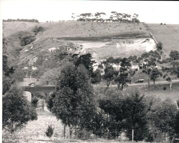
The Kaolin Quarry at Bulla supplied Kaolin to the Northcote and Brunswick Pottery Works until it ceased operation at that site in the 1950s. The three arched bluestone bridge r3placed a ford crossing across Deep Creek, which along with Jacksons Creek flows into the Maribyrnong River.A black and white photograph of the Deep Creek and three arched bluestone bridge in the Bulla Township with the Kaolin Quarry in the background. One truck is crossing the bridge with a tanker approaching the bridge at the bottom of the Bulla Hill.deep creek, bridges, kaolin quarries, quarries, george evans collection -
 Clunes Museum
Photograph, C. NETTLETON, GOVERNMENT BRIDGE, CLUNES, SOUTH WEST
PHOTOGRAPH, - VIEW TAKEN FROM GEORGE STREET SHOWING LANDSCAPE, GOVERNMENT BRIDGE - LOOKING SOUTH WEST. .1 SEPIA PHOTOGRAPH MOUNTED ON CARDBOARD .2 SEPIA PHOTO PRINT .3 BLACK AND WHITE PHOTO PRINT .4 SMALL BLACK AND WHITE PHOTO PRINT .5 SMALL BLACK AND WHITE PHOTO PRINT GOVERNMENT BRIDGE CLUNES. SOUTH WESTlocal history, photography, photographs, bridges and buildings -
Phillip Island and District Historical Society Inc.
Photograph, 1968
Part of an album compiled and donated by Mrs Helen Jansson. Construction of second Phillip Island Bridge to San Remo, 1968/69.Overhead close up of span supports with Crane Railway at left - old Bridge diagonally top left. Construction of second Phillip Island Bridge 1968/69.John Squire Photographylocal history, photography, photographs, slides, film, civil engineering, bridges, phillip island bridges, black & white photograph, mrs helen jansson, phillip island bridge