Showing 697 items
matching bullock
-
 Glen Eira Historical Society
Document - Tucker Road, 240, McKinnon
A photocopy of undated research notes by Hilary Bullock f Brighton Historical Society describing the history of the property at 240 Tucker Road, McKinnon includes a brief history of the area and a list of the tenants from 1880 to 1955.tucker road, mckinnon, masters william h., manchester road, north road, draper thomas t., masters w. h. and co., electrical apparatus, market gardeners, market gardens, mcdonald henry, hewton d.r., church of england centre road, centre road, marquis leslie, monger arthur, devereaux john, priddeth charles, ianson h., chinese community, andrews james h., builders, land subdivisions, manufacturing industry, telegraph, telephones -
Stawell Historical Society Inc
Memorabilia - Realia, Stawell High School Medallion
Medallion around 1911 -1912, belonged to Mrs Mabel Rogers Nee Bullock, who apparently boarded with her aunt Eliza Porter, while attending Stawell High School. Issued as Part of School UniformMetal Gold Paint. Outline Shield Navy Top left triangle with gold S paint. Diagonal bar divides shield. Gold paint outlines red Bar with School Moto. Lower navy triangle ahs gold paint H.S. Shield enclosed with gold Paint Laurel wreath.S Et VIDERI ET POSSE H.Seducation -
Glenelg Shire Council Cultural Collection
Souvenir - Salt and Pepper Shakers, 1984
China salt and pepper shakes. Shape of oven and basin, beige and brown. Oven flat one side, black stamp, bullock dray, '150th Anniversary' in banner above dray; 'VICTORIA' in banner beneath dray. Identifying numbers 6232 a, b -
Bendigo Historical Society Inc.
Map - SALISBURY : COUNTY OF BENDIGO, 1965
Map. Salisbury, County of Bendigo, Pompapiel, Yallook, Yarraberb, Yarrayne, Bullock Creek. Drawn and reproduced at the Department of Lands and Survey, Melbourne. Price $1.00. 1965. By authority A.C. Brooks, Government Printer, Melbourne. (number 28 in map cupboard 1)A.C. Brooks,Government Printer, Melbourne.map, bendigo, salisbury -
Bendigo Historical Society Inc.
Map - SALISBURY : COUNTY OF BENDIGO, 1965
Map. Salisbury, County of Bendigo, Pompapiel, Yarrayne, Yarraberb, Yallook, Bullock Creek. By Authority: A.C. Brooks, Government Printer, Melbourne. Drawn and reproduced at the Department of Lands and Survey, Melbourne.1965. Price $1.00. (number 6 in map cupboard 1)A.C. Brooks, Government Printermap, bendigo, salisbury -
 Bendigo Historical Society Inc.
Newspaper - JENNY FOLEY COLLECTION: SERENITY
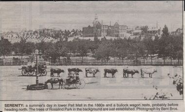
Bendigo Advertiser "The way we were" from 1999. Serenity: a summer's day in lower Pall Mall in the 1880s and a bullock wagon rests, probably before heading north. The trees of Rosqalind Park in the background are just established. Photograph by Bent Bros.newspaper, bendigo advertiser, the way we were -
 Lakes Entrance Historical Society
Photograph - TAFE building, 2005
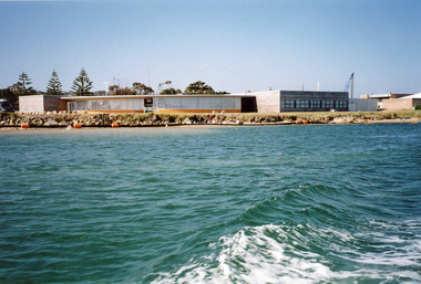
Date made September 2005Colour photograph of the RMIT TAFE Educational Facility on Bullock Island, taken from the Cunninghame Arm. It shows the brick administration building, and the timber SEAMEC building. To the right of the photo is Lakes Entrance Fishermens Co-op building. Lakes Entrance Victoriaeducation, buildings -
 Lakes Entrance Historical Society
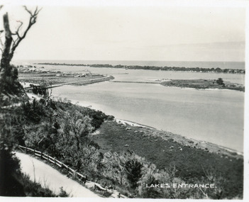
Photograph - Lakes Entrance, 1997c
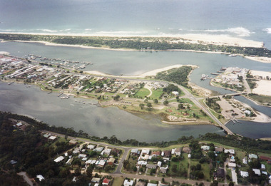
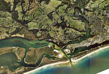
Colour print of aerial view looking south of western side of township. Shows housing on Kalimna Hill, North Arm, part of Bullock Island, Cunninghame Arm, the outer barrier and east pier of man made entrance. Lakes Entrance Victoriawaterways, township -
 Lakes Entrance Historical Society
Photograph - The Entrance, 1995c
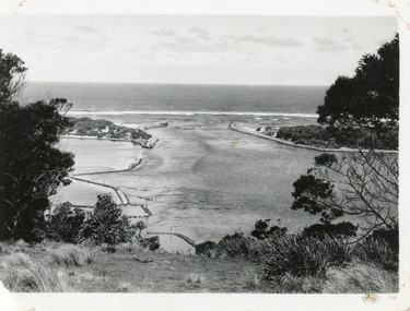
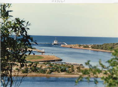
Colour photograph of the entrance from Bass Strait to the Gippsland Lakes, it shows the western end of Bullock Island and the built up area below Jemmys Point, both made during dredging operations over many years. Lakes Entrance Victoriaislands, fishing industry, waterways -
 Lakes Entrance Historical Society
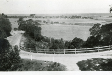
Photograph - The Entrance, 1930c
Black and white photograph showing wooden piers at entrance to Bass Strait from the Gippsland Lakes. Buildings on sand dunes, Bullock Island and rock groynes. Photo taken from Jemmys Point showing shrubbery in foreground. Lakes Entrance Victoriawaterways, topography, boats and boating, islands -
 Lakes Entrance Historical Society
Postcard - The Entrance, Valentine Series, 1935c
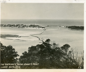
Hand tinted postcard of the man-made entrance to the Gippsland Lakes, taken from Jemmys Point. It shows the rock groynes at Bullock Island and Entrance to North Arm, a barge in North Arm directly below Jemmys Point. Lakes Entrance Victoriaislands, waterways, topography -
 Lakes Entrance Historical Society
Photograph - Lakes Entrance, Gippsland Ports, 2006 c
Second copyColour aerial photograph of entrance from Bass Strait to Gippsland Lakes including Bullock Island Reeves Channel Rigby Island houses on Kalimna Hill and Princes Highway winding down Jemmys Point hill into township of Lakes Entrance Victoriaaerial photograph, ocean, waterways -
 Lakes Entrance Historical Society
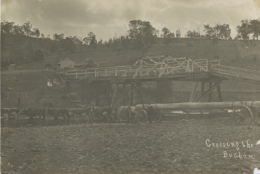
Photograph, John Flynn, Crossing the Buchan, 1906
Bridge was built in 1896 and never finishedBlack and white photograph of bullock team pulling timber jinker with very long logs across the Buchan River beside the footbridge. Several men in charge of team and four girls on the hill, cottage and barn seen, bridge not finished Buchan VictoriaCrossing the Buchantransport, waterways, bridges, people -
 Southern Sherbrooke Historical Society Inc.
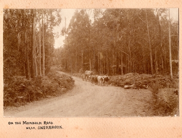
Photograph, On the Monbulk Road near Sherbrooke
Photo shows a team of cattle (bullocks, cows or steers) hauling a log down to the sawmill. A huge piece of timber is clearly seen chained to the dray. Heavy timber both sides of the road, most likely present-day Sherbrooke Forest. c.1920. -
 Lakes Entrance Historical Society
Postcard - Bullock Island, 1935c
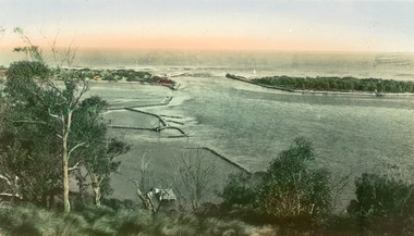
Also faded postcard same imageBlack and white small format postcard of the Princes Highway as it winds around Jemmys Point. It shows the North Arm bridge, narrow bridge to Bullock Island, glimpse of the western part of town, hummocks of southern shore of Cunninghame Arm. Lakes Entrance VictoriaLakes Entrancefences, roads and streets, islands -
 Lakes Entrance Historical Society
Postcard, Bulmer H D, 1950c
Also one other postcard same donated by M & V Carpenter in spares box.Black and white postcard of the Princes Highway Jemmys Point, showing Bullock Island between North Arm and Cunninghame Arm, distant view of the entrance from Bass Strait to the Gippsland Lakes. Post and rail fence along roadside. Lakes Entrance VictoriaPrinces Highway and a view of the Entrance vegetation, roads and streets -
 Lakes Entrance Historical Society
Photograph - Topography, 2007c
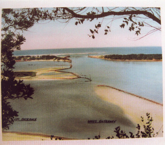
Colour aerial photograph of the land forms around the entrance to the Gippsland Lakes, from Kalimna West to Lakes Entrance, North Arm to the ocean. Shows massive sand buildup between Rigby Island and Kalimna, also Bullock Island. Lakes Entrance Victoriawaterways, navigation, topography -
 Lakes Entrance Historical Society
Photograph - The Entrance, Calvert Barbara, 1960c
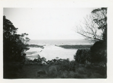
Black and white photograph of the man-made entrance from Bass Strait to the Gippsland Lakes taken from Jemmys Point. It also shows the rock groynes at Bullock Island with dredged sand starting to fill the basins to enlarge the island. Lakes Entrance Victoriawaterways, public works -
 Lakes Entrance Historical Society
Photograph - The Entrance, 1920c
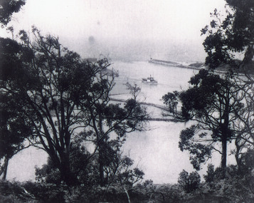
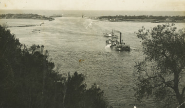
Black and white photograph of the man-made entrance from Bass Strait to the Gippsland Lakes, taken from the road at Jemmys Point. It also shows the rock groynes at Bullock Island. A steamer is entering the lakes from Cunninghame Arm. Lakes Entrance Victoriawaterways, ships and shipping -
 Lakes Entrance Historical Society
Postcard - Dredge Pioneer, Segerberg and Bulmer, 1910 c
Message on back Arrived safe 25th have a good time hoping you are well from FCG Addressed to Mrs FC Gason, Jessops Hill, Lower NicholsonBlack and white postcard showing dredge Pioneer working below Jemmys Point facing entrance rock groynes on west of Bullock Island calm entrance in distance steamer JCD heading across Reeves Channel after leaving Lakes Entrance VictoriaLakes Entrance waterways, dredges, correspondence -
 Stawell Historical Society Inc
Photograph, Stawell High School Students 1969 from 4A
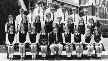
6975-12 Stawell High School Form 4A 1969 Teacher Mr Bullock Top Row, Brian Pawsey, Denis Bell, James Ritchie Second Row, Lance Ferguson, Hartley Budd, Ian Davies, Dallas Bibby, Maurice Stewart, Andrew Jackson, Rodney Guy Third Row, Elwyn Erwin, Sherayl Bennett, Kerry Cordor, Pam Joy, Rhonda Christian, Janis Graham, Bev Cameron, Rosalie Clarke Front Row, Janet Allen, Kathy Jenkins, Ann Holloway, Michelle Cox, Mr Bullock, Julie Cox, Jill Ball, Pam Gercovich, Jenny Jolly Students in uniform with Teacher in front of Main BuildingStawell High School Form 4A 1969education -
 Kew Historical Society Inc
Photograph, Kilby Farm, Kew East
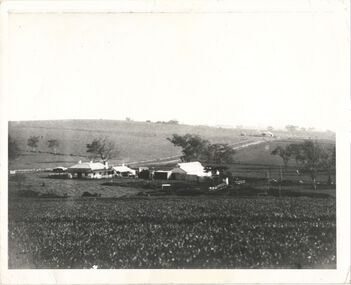
Kilby Lodge (c.1845-c.1922). William Oswin purchased Crown Land Lots 52 & 53 in 1845. These lots ran north from an old bullock track [later Kilby Road] to the Yarra, and east to Burke Road. Oswin purchased a neighbouring Lot in 1851, separated by the bullock track from the rest of the farm. Oswin built ‘Kilby Lodge’ and, with his brother, farmed dairy cattle on the site. Oswin’s descendants owned the farm into the 1890s. New subdivisions of Kilby and neighbouring farms in the 1920s changed the rural nature of north Kew. Housing and large recreation reserves replaced dairy farms and market gardens. This work forms part of the collection assembled by the historian Dorothy Rogers, that was donated to the Kew Historical Society by her son John Rogers in 2015. The manuscripts, photographs, maps, and documents were sourced by her from both family and local collections or produced as references for her print publications. Many were directly used by Rogers in writing ‘Lovely Old Homes of Kew’ (1961) and 'A History of Kew' (1973), or the numerous articles on local history that she produced for suburban newspapers. Most of the photographs in the collection include detailed annotations in her hand. The Rogers Collection provides a comprehensive insight into the working habits of a historian in the 1960s and 1970s. Together it forms the largest privately-donated collection within the archives of the Kew Historical Society.A panoramic photograph of Kilby (or Oswin's) Farm in East Kew."Kilby Farm when Oswins owned it. Commenced 1845."kilby farm, kilby lodge, william oswin, dorothy rogers, kew east -
Glenelg Shire Council Cultural Collection
Souvenir - Souvenir Wine Glass, c. 1985
Wine glass, souvenir of Heywood's 150th 1835 - 1985. Gold rim on top, gold depiction of bullock dray, with 'Heywood 150th' above and '1835 - 1985' below, in gold. Opposite side of glass has history of the Heywood Fitzroy River bridge in gold print.souvenir, heywood, 150th anniversary, 1835 to 1985 -
 Lakes Entrance Historical Society
Photograph - The Entrance, 1945c
Other copiesHand tinted colour photograph of the man-made entrance from Bass Strait to the Gippsland lakes, taken from Jemmys Point. It also shows the rock groynes at the western end of Bullock Island, and at the entrances to Cunninghame Arm and the North Arm. Lakes Entrance VictoriaThe Entrance, Lakes Entranceislands, waterways, boats and boating -
 Lakes Entrance Historical Society
Photograph - The Entrance, Tambo Shire, 1990
Colour photograph showing the entrance to the lakes from Bass Strait, dredge April Hamer working on the bar. Western spit on right, eastern spit hidden behind bush, Bullock Island on left centre, mouth of North Arm in foreground, Lakes Entrance, Victoria.waterways, islands, township -
 Lakes Entrance Historical Society
Photograph, 2001
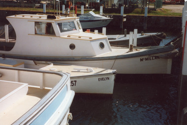
Date made November 2001Colour photograph of boats tied up at the Ports Jetty on Bullock Island. Small cabin cruiser called McMillan, open cockpit workboat called Evelyn, in foreground transom of larger cabin cruiser and in the background is a small aluminium run about. Lakes Entrance Victoriaships and shipping, dredging, jetties -
 Lakes Entrance Historical Society
Postcard - The Entrance, 1940c
Originally in a pack of miniature postcards produced for sale to tourists.Black and white small format postcard of the Western end of Bullock Island, Reeves and Entrance Channels, the Entrance and Carpenter Town at the New Works. Taken from Jemmys Point, it shows rock groynes built to channel water flow to the Entrance. Lakes Entrance VictoriaThe Entrance Jemmys Point Lakes Entrance V2 topography, waterways -
 Lakes Entrance Historical Society
Postcard - North Arm, Valentine Series, 1930c
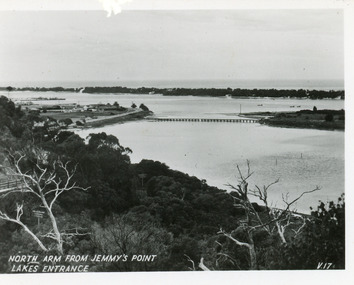
This is the before paired photograph used in the 150 year Lakes Entrance 1858-2008 display.|The after paired photograph number is 01590.1 Also one 12 x 16 framed photograph used in room display.Black and white small format postcard of North Arm and Cunninghame Arm of Gippsland Lakes, taken from Jemmys Point, Club Hotel at western end of town, bridge to Bullock Island, scrub covered hummocks and Bass Strait in distance. Lakes Entrance VictoriaNorth Arm from Jemmys Point Lakes Entrancebridges, islands, waterways, topography -
Glen Eira Historical Society
Document - Denver Crescent, 18, Elsternwick, 'Wendouree'
A copy of a typed report dated 25/2/1989 concerning 18 Denver Crescent, Elsternwick by H Bullock and Rosalind Landells. The report contains a description of the location and of the residents of the house. An undated unattributed handwritten draft of part of the report is also included.dixon edward r, morrell george h, stocker hw, bullock h, rosalind landells, denver crescent, elsternwick, o’neill henry, o’neill college estate, brighton historical society, houses, land subdivision, wendouree -
Glen Eira Historical Society
Document - Balaclava Road, 91, Caulfield North, 'Miami'
Typed notes on the history and past owners of the house 'Miami', Balaclava Road, 91, Caulfield North, by Hilary Bullock and Rosalind Landells of the Brighton Historical Society, dated 9/09/1988. The file also includes is an additional handwritten summary of the information.miami, balaclava road, otira road, bendigo road, caulfield north, dixson francis, mcharg gerald, dean c r, walker a g, bullock hilary, landells rosalind