Showing 663 items
matching bullocks
-
 Lakes Entrance Regional Historical Society (operating as Lakes Entrance History Centre & Museum)
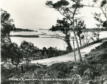
Postcard, 1930c
Also faded copy identical imageBlack and white small format postcard of the Princes Highway at Jemmys Point. It shows the road winding around the hill between the scrub covered hill and the post and rail guard fence, Bullock Island and rock groynes in the lake also entrance in distance. Lakes Entrance VictoriaPrinces Highway, Lakes Entranceislands, fences, vegetation -
 Lakes Entrance Regional Historical Society (operating as Lakes Entrance History Centre & Museum)
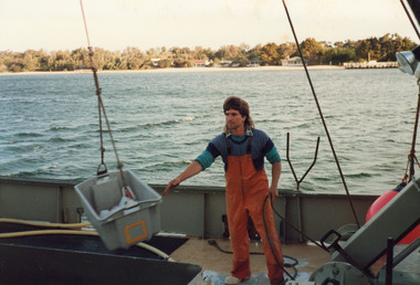
Photograph, Hammarstrom Ian, 1986 c
Colour photograph taken on the deck of fishing boat Tarpeena at Co-op jetty, Bullock Island, shows deck hand Gerald Rice at work during unloading of catch from fish well. Cunninghame Arm and New Works cottages in image. Lakes Entrance Victoriaships and shipping, fishing industry, ocean -
 Stawell Historical Society Inc
Memorabilia - Realia, Stawell High School Medallion
Medallion around 1911 -1912, belonged to Mrs Mabel Rogers Nee Bullock, who apparently boarded with her aunt Eliza Porter, while attending Stawell High School. Issued as Part of School UniformMetal Gold Paint. Outline Shield Navy Top left triangle with gold S paint. Diagonal bar divides shield. Gold paint outlines red Bar with School Moto. Lower navy triangle ahs gold paint H.S. Shield enclosed with gold Paint Laurel wreath.S Et VIDERI ET POSSE H.Seducation -
Glen Eira Historical Society
Document - Tucker Road, 240, McKinnon
A photocopy of undated research notes by Hilary Bullock f Brighton Historical Society describing the history of the property at 240 Tucker Road, McKinnon includes a brief history of the area and a list of the tenants from 1880 to 1955.tucker road, mckinnon, masters william h., manchester road, north road, draper thomas t., masters w. h. and co., electrical apparatus, market gardeners, market gardens, mcdonald henry, hewton d.r., church of england centre road, centre road, marquis leslie, monger arthur, devereaux john, priddeth charles, ianson h., chinese community, andrews james h., builders, land subdivisions, manufacturing industry, telegraph, telephones -
Lakes Entrance Regional Historical Society (operating as Lakes Entrance History Centre & Museum)
Photograph, M Holding, 1985 c
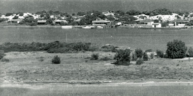
The town section of North Arm previously known as The BlackwaterColour photograph taken from Kalimna Heights showing outer barrier and entrance channel. Road and new bridge to Bullock Island Apex Park beside North Arm in foreground has old playground equipment with timber fort and hillock with underground tunnel Lakes Entrance Victoriaholland, topography, waterways -
 Lakes Entrance Regional Historical Society (operating as Lakes Entrance History Centre & Museum)
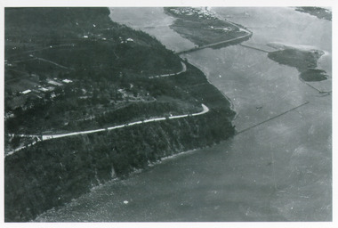
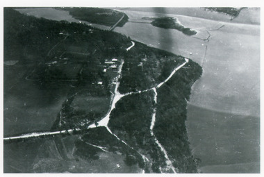
Photograph, Bulmer H D, 1940c
Black and white photograph of aerial view of Kalimna Heights, showing scattered buildings, Princes Highway around side of cliff, western end of township, North Arm bridge, footbridge to Bullock Island, and rock groynes. Track to lookout and signal beacon visible. Lakes Entrance Victoriaboats and boating, jetties, waterways, vegetation -
 Lakes Entrance Regional Historical Society (operating as Lakes Entrance History Centre & Museum)
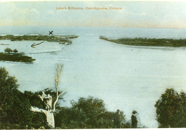
Postcard, 1900c
Also copy tinted postcard 10 x 15Coloured post card of the man made entrance through the sand dunes, taken from Jemmys Point. It shows the works and settlement at the entrance, Bullock Island and groynes to direct flow of lake waters towards entrance. Two men standing on Jemmys Point. Lakes Entrance VictoriaLakes Entrance, Cunninghame, Victoriaislands, waterways, topography, public works -
 Lakes Entrance Regional Historical Society (operating as Lakes Entrance History Centre & Museum)
Photograph, 1920c
Copied from a copy in possession of J WhadcoatBlack and white photograph showing view of seven cottages on dunes. View of several boats at jetties and on slipway, white shed on New Works wharf, Cunninghame Arm in front of cottages, part of Bullock Island showing some vegetation and one telegraph pole. Lakes Entrance Victoriawaterways, jetties, islands, accommodation -
 Lakes Entrance Regional Historical Society (operating as Lakes Entrance History Centre & Museum)
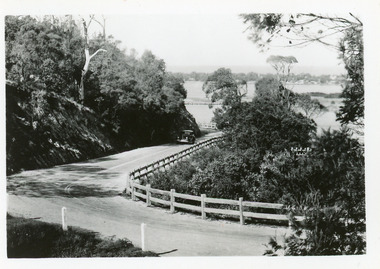
Postcard, 1940c
Plus 3 identical black and white|Plus 2 tinted, (one tinted copy has inscription, 'Jemmy's Point')Black and white small format postcard of the road as it winds around Jemmys Point. It shows a motor car travelling up the hill between the steep cliff of the road cutting and the post and rail guard fence. Glimpse of Bullock Island, lake and hummocks in distance. Lakes Entrance Victoriafences, roads and streets, transport, coast -
 Lakes Entrance Regional Historical Society (operating as Lakes Entrance History Centre & Museum)
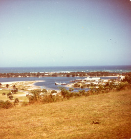
Photograph, Fraser Ian, 1975c
Color photograph of the eastern part of Bullock Island, showing buildings of Lakes Entrance Fishing Co-Operative and PWD, spit opposite Club Hotel has been sown with grass, hummocks and Bass Strait in distance. Taken from Seaview Parade Kalimna. Lakes Entrance Victoriawaterways, islands, land reclamation, topography -
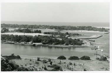
 Lakes Entrance Regional Historical Society (operating as Lakes Entrance History Centre & Museum)
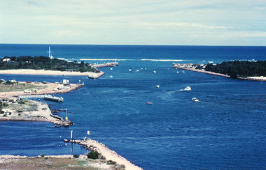
Photograph, Fraser Ian, 1995c
Colour photograph of the entrance from Bass Strait to the Gippsland Lakes. It shows the western end of Bullock Island and the entrance to North Arm, cars parked on island and many people fishing. This area built up during dredging operations over many years. Lakes Entrance Victoriaislands, topography, fishing industry, land reclamation -
 Lakes Entrance Regional Historical Society (operating as Lakes Entrance History Centre & Museum)
Photograph, 1990c
Black and white photograph of the entrance. It shows two fishing boats moored in North Arm, western end of Bullock Island with Fishermens Co-op building, and area below Jemmys Point, both formed during dredging operations over many years. Lakes Entrance Victoriaeducation, waterfront, room display -
Bendigo Historical Society Inc.
Map - CAMPBELL COLLECTION: BENDIGO & DISTRICT MAPS
Map. Lockwood, Parishes of Lockwood and Shelbourne. Scale 20 chains to 1 inch.Total area 4405 acres. Bullock Creek to the right, Spring Creek at Centre. Newbridge is 11 miles N E, To Marong, Bendigo Lockwood roads are on the left. (number 375 in map cupboard 1)map, bendigo, agricultural lands -
 Kew Historical Society Inc
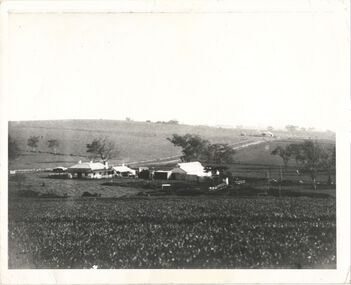
Photograph, Kilby Farm, Kew East, Before 1920
Kilby Lodge (c.1845-c.1922). William Oswin purchased Crown Land Lots 52 & 53 in 1845. These lots ran north from an old bullock track [later Kilby Road] to the Yarra, and east to Burke Road. Oswin purchased a neighbouring Lot in 1851, separated by the bullock track from the rest of the farm. Oswin built ‘Kilby Lodge’ and, with his brother, farmed dairy cattle on the site. Oswin’s descendants owned the farm into the 1890s. New subdivisions of Kilby and neighbouring farms in the 1920s changed the rural nature of north Kew. Housing and large recreation reserves replaced dairy farms and market gardens. This work forms part of the collection assembled by the historian Dorothy Rogers, that was donated to the Kew Historical Society by her son John Rogers in 2015. The manuscripts, photographs, maps, and documents were sourced by her from both family and local collections or produced as references for her print publications. Many were directly used by Rogers in writing ‘Lovely Old Homes of Kew’ (1961) and 'A History of Kew' (1973), or the numerous articles on local history that she produced for suburban newspapers. Most of the photographs in the collection include detailed annotations in her hand. The Rogers Collection provides a comprehensive insight into the working habits of a historian in the 1960s and 1970s. Together it forms the largest privately-donated collection within the archives of the Kew Historical Society.A panoramic photograph of Kilby (or Oswin's) Farm in East Kew."Kilby Farm when Oswins owned it. Commenced 1845."kilby farm, kilby lodge, william oswin, dorothy rogers, kew east -
 Stawell Historical Society Inc
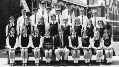
Photograph, Stawell High School Students 1969 from 4A
6975-12 Stawell High School Form 4A 1969 Teacher Mr Bullock Top Row, Brian Pawsey, Denis Bell, James Ritchie Second Row, Lance Ferguson, Hartley Budd, Ian Davies, Dallas Bibby, Maurice Stewart, Andrew Jackson, Rodney Guy Third Row, Elwyn Erwin, Sherayl Bennett, Kerry Cordor, Pam Joy, Rhonda Christian, Janis Graham, Bev Cameron, Rosalie Clarke Front Row, Janet Allen, Kathy Jenkins, Ann Holloway, Michelle Cox, Mr Bullock, Julie Cox, Jill Ball, Pam Gercovich, Jenny Jolly Students in uniform with Teacher in front of Main BuildingStawell High School Form 4A 1969education -
 Kiewa Valley Historical Society
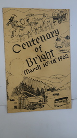
Booklet - Bright, Centenary of Bright March 10th - 18th, 1962
Township of Bright celebrated its centenary during the week from 10th - 18th March, 1962. This booklet outlines the program for the week.Bright is a nearby town to the the Kiewa Valley and currently the location of the current Shire (Alpine). The program gives historical information on activities in the early 1960s.Yellowy/Orange cover with brown title and sketch. One sketch is at the bottom and includes hills, pines, saw mill and bus. Sketch at the top is of a bullock team and in the middle on the right a gold miner. Inside cover has print as has both sides of the 4 pages held by 2 staples. 'C. Roper' on inside of the front cover.bright, centenary of bright -
Port Melbourne Historical & Preservation Society
Postcard - Swallow & Ariell promotion, On the Road
"On the Road" Coloured postcard, front shows a bullock team and dray in front of a bark hut. Large gum tree on right and hills behind. Back shows Swallow & Ariell's renowned biscuits and cakes, pure jams and canned fruits. Plum puddings and Australian seeded raisins etc. are the bestindustry - food, swallow & ariell ltd -
 Lakes Entrance Regional Historical Society (operating as Lakes Entrance History Centre & Museum)
Photograph, Bulmer H D, 1940c
Black and white photograph of aerial view of Kalimna escarpment, Princes Highway, road to Kalimna Hotel, scattering of buildings including Gainsborough House, in distance is North Arm bridge, footbridge to undeveloped Bullock Island with rock groynes in place. Part of eastern pier of entrance at Lakes Entrance, Victoria.jetties, waterways, topography, township -
 Lakes Entrance Regional Historical Society (operating as Lakes Entrance History Centre & Museum)
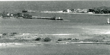
Photograph, 1920c
Copied from photograph in possession of J WhadcoatBlack and white photograph showing stone piers at entrance to Gippsland Lakes from ocean - Bass Strait. Eastern pier on left, dune and western pier on right. Cranes and some work sheds on left. Navigation light on tip of Bullock Island on extreme right. Lakes Entrance Victoriajetties, waterways, topography, township -
 Bendigo Historical Society Inc.
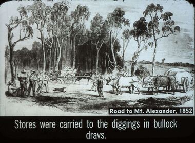
Slide - DIGGERS & MINING. STORES AT THE DIGGINGS, c1852
Diggers & Mining. Stores at the diggings. Road to Mt. Alexander, 1852. Stores were carried to the diggings in bullock drays. Slide shows travellers with swags and drays pulled by ox, with stores also a horse pulling a dray with supplies. Markings: 37 994.LIF. 5. Used as a teaching aid.hanimounteducation, tertiary, goldfields -
Bendigo Historical Society Inc.
Map - BRIDGEWATER : COUNTY OF BENDIGO, 6-10-27
Map. Bridgewater, County of Bendigo, Inglewood, Salisbury, Derby, Leichardt, Yarraberb, Yarrayne, Bullock Creek, Loddon River, Sandhurst and Inglewood Railway. Photo-Lithographed at the Department of Lands and Survey Melbourne by W.J. Butson, 6-10-27. Price 1/-. (number 53 in map cupboard 1)W.J. Butsonmap, bendigo, bridgewater -
 Stawell Historical Society Inc
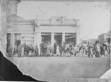
Photograph, Chaponnel, Bush and Allen Butcher’s Shop in Main Street Stawell built 1876
Chaponnel Bush and Allen Butcher’s Shop Main Street Stawell built 1876. Butchers in aprons and horse drawn carts lined up in the street in front Note the Bullocks Head in centre of Parapet. Also Wertheim Sewing Machines on building beside it.stawell business streetscape -
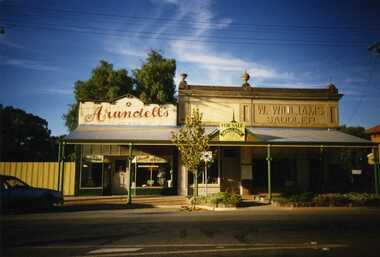 Charlton Golden Grains Museum Inc
Photograph, Charlton High Street 1988, 1988
Photo taken by R. Brownjohn in 1988 of three shops in the centre of High St, Charlton. Arundell's shoe shop, former Stock & Station Agency and Williams Saddlery (later Bullocks Grocery). The buildings were later demolished to become the Traveller's RestColour photograph of Vic Arundell's Shoe Shop, and former W. Williams Saddlery shop. For Sale sign over centre building. car parked in left of photo. East Charlton Hotel in background on RH side of photo.arundell's shoe shop, williams saddlery, bullocks grocery -
Glen Eira Historical Society
Document - Denver Crescent, 18, Elsternwick, 'Wendouree'
A copy of a typed report dated 25/2/1989 concerning 18 Denver Crescent, Elsternwick by H Bullock and Rosalind Landells. The report contains a description of the location and of the residents of the house. An undated unattributed handwritten draft of part of the report is also included.dixon edward r, morrell george h, stocker hw, bullock h, rosalind landells, denver crescent, elsternwick, o’neill henry, o’neill college estate, brighton historical society, houses, land subdivision, wendouree -
Glen Eira Historical Society
Document - Balaclava Road, 91, Caulfield North, 'Miami'
Typed notes on the history and past owners of the house 'Miami', Balaclava Road, 91, Caulfield North, by Hilary Bullock and Rosalind Landells of the Brighton Historical Society, dated 9/09/1988. The file also includes is an additional handwritten summary of the information.miami, balaclava road, otira road, bendigo road, caulfield north, dixson francis, mcharg gerald, dean c r, walker a g, bullock hilary, landells rosalind -
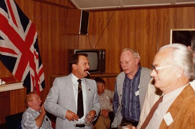 8th/13th Victorian Mounted Rifles Regimental Collection
Photograph
Cambrai Day is celebrated annually by Armoured Corps regiments of the British Commonwealth. It marks the anniversary of the Battle of Cambrai in November 1917 when a force of more than 400 British Mark IV Tanks broke the defences of the German Hindenburg Line, It was the first large-scale, effective use of tanks in warfare. Cambrai turned from a battle of great success to failure, but it heralded a new type of warfare and changed the nature of the battlefield forever.The gathering at Buna Barracks Albury, Beersheba Barracks Wangaratta, Bapaume Barracks Benalla and Salamaua Barracks Cobram on 30 November 1986 was the inaugural meeting of the 8th/13th Victorian Mounted Rifles Regimental Association.Colour photograph of group in mess building at Buna Barracks Albury on Cambrai Day 30 November 1986. From left : seated Corporal Cook Bruce Bullock, majors Robert Morrison, Ian Docking and Max Oates. All were former members of 8/13 Victorian Mounted Rifles. -
 Halls Gap & Grampians Historical Society
Photograph
A temporary saw-mill in the central Grampians.Photo shows a clearing containing a saw mill. There is a saw with traction engine to the right ands a bullock wagon containing a large log to the left. There is a man to the right working with the engine, four men among the wood in the centre and two men near the wagon on the left. A large wood stump is prominent in the foreground. timber industries, logging, sawmilling -
Lakes Entrance Regional Historical Society (operating as Lakes Entrance History Centre & Museum)
Photograph, G W Holding, 1/04/1979 12:00:00 AM
Also a colour photograph of similar view of event named King of the Straits. Not held again at this venue due to dangerous conditions in Bass Strait. number 04234.1 size 9 x 13 cmColour photograph showing the Entrance, power boats in the ocean contestants in the Offshore Powerboat Race hosted by the Gippsland Lakes Boating Club, six power boats in the lake. Good view of rock groynes at entrance to North Arm and clay and gravel filling on Bullock Island extension, Lakes Entrance Victoriamachinery, waterways -
Lakes Entrance Regional Historical Society (operating as Lakes Entrance History Centre & Museum)
Photograph, 1960 c
Also two black and white photographs taken of Entrance from Jemmys Point taken 1960 c 04310.1 and 04310.2 size 11.5 x 16 cmBlack and white photograph of the entrance taken from a bend in the Princes Highway showing three cars parked at the viewing area beside the highway. Boat and dredge in waterway below highway dredged sand in Bullock Island extension, dredge Mathew Flinders working outside the entrance Lakes Entrance Victoriafishing industry, people, parks, jetties -
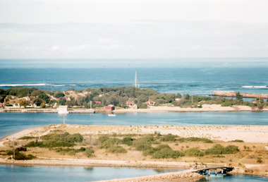 Lakes Entrance Regional Historical Society (operating as Lakes Entrance History Centre & Museum)
Photograph, Scarce Keith, 1962
Date made May 1962Colour photograph of Bullock Island. It shows the causeway and raised bridge to the island, Cunninghame Arm, dwellings and jetty at hummocks, western pier of entrance, sandy area of island planted with grass. Taken prior to transfer of PWD to island, and before Pecks factory and Fishermens Co-Operative. Lakes Entrance Victoriaislands, waterways, land reclamation, fishing industry