Showing 966 items
matching connector
-
 Emerald Museum & Nobelius Heritage Park
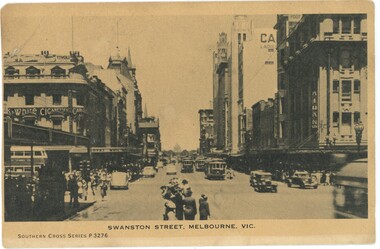
Postcard - Postcard of Swanston Street, Melbourne c1940s
This postcard is part of an album of postcards which date from late 19th century to mid 20th century. This card is one of two cards which directly connects the album with an Emerald resident. The writer, O E Cowper was the wife of Percy Cowper who was the Emerald Postmaster 1929-1947. The couple appear to have been on a short holiday in the city. The postcard message refers to an Emerald resident, Mr Legge.This postcard in an album of postcards dating from the late 19th century to mid 20th century. It reflects the popularity of collecting postcards in Australia which reached a height in the early 1900s until around 1920. Post Card of Swanston Street, Melbourne c1930s. Black and white photographic image.On front at bottom of image: 'SWANSTON STREET, MELBOURNE, VIC. / SOUTHERN CROSS SERIES P3276' Back of image: Handwritten message 'Dear Elsie / We are having a nice holiday but I feel / pretty tired today. Too much walking yes- / terday & a North Wind. We went to / see Mr Legge in the Hospital the / other day as we were passing there. / How are the Chooks? How is Quilthy getting / on? She didn't try to follow us. / Regards to Mum, Mrs Fielder & [?]Sheila / Yours as ever O E Cowperpostcard album, swanston street, 1940s, "green postcard album" -
 Dutch Australian Heritage Centre Victoria
Etching
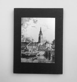
The Vliet is a canal in the western Netherlands, in the province of South Holland. It starts at the Oude Rijn at Leiden and joins the Delfshavense Schie canal at Delft. Places along its banks include Voorschoten, Leidschendam, Voorburg, The Hague and Rijswijk. The canal was dug in 47 AD under command of Roman general Corbulo, who wished to connect the river Rhine, of which the current Oude Rijn stream in Roman times was the main branch, to the Meuse estuary. It is unclear what the canal's trajectory was beyond the current city of Delft; the Delfshavense Schie canal, which connects Delft to the Nieuwe Maas river was not dug until 1389. In the Middle Ages the Vliet was an important trade link that attracted all kinds of trade, as it flowed through the heart of the County of Holland. Windmills have been constructed alongside the Vliet, including the completely renovated mill 'De salamander' in Leidschendam. The Vliet area was particularly attractive among richer families, who built their mansions along its banks.An historic small town scene etched (or possibly printed) on thin metal and subsequently fastened to a plywood backing. The delicately presented scene is said to show the intersection of Old Church Street and the Vliet Canal bridge in Voorburg, as well as a section of wharf. On the canal are one large and two much smaller vessels. A very tall crane-like construction arises from the wharf to the roof of waterside buildings. The people are soberly dressed in possibly 17th or 18th century costumes.On the reverse has been written: "Oude Kerkstraat Brug over de Vliet Voorburg". (Old Church Street; Bridge over the Vliet canal; Voorburg). However, research proves that the church is actually the Old Church in Delft, a short distance further down the Vliet Canal. -
 Eltham District Historical Society Inc
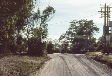
Slide, Bonds Road, Lower Plenty, Mar. 1981
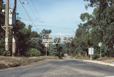
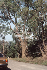
One of a series of images of road infrastructure focussed on Bonds Road, Lower Plenty, the section connecting Old Eltham Road with Rosehill Road, taken by Eltham Shire Council Planning and Engineering officers. They provide perspective of the changes in housing styles and road development that began sweeping in from the mid 1970s with increasing urbanisation of what was once more outlying suburbs and regions. All images have been identified with GPS35 mm colour positive transparency (1 of 13) Mount - Kodak Kodachrome CardProcessed Mar 1981infrastructure, roads, bonds road, lower plenty, old eltham road -
 Eltham District Historical Society Inc
Slide, Bonds Road, Lower Plenty, Mar. 1981
One of a series of images of road infrastructure focussed on Bonds Road, Lower Plenty, the section connecting Old Eltham Road with Rosehill Road, taken by Eltham Shire Council Planning and Engineering officers. They provide perspective of the changes in housing styles and road development that began sweeping in from the mid 1970s with increasing urbanisation of what was once more outlying suburbs and regions. All images have been identified with GPS35 mm colour positive transparency (1 of 13) Mount - Kodak Kodachrome CardProcessed Mar 1981infrastructure, roads, bonds road, lower plenty -
 Eltham District Historical Society Inc
Slide, Bonds Road, Lower Plenty, Mar. 1981
One of a series of images of road infrastructure focussed on Bonds Road, Lower Plenty, the section connecting Old Eltham Road with Rosehill Road, taken by Eltham Shire Council Planning and Engineering officers. They provide perspective of the changes in housing styles and road development that began sweeping in from the mid 1970s with increasing urbanisation of what was once more outlying suburbs and regions. All images have been identified with GPS35 mm colour positive transparency (1 of 13) Mount - Kodak Kodachrome CardProcessed Mar 1981infrastructure, roads, bonds road, lower plenty, rosehill road -
 Eltham District Historical Society Inc
Slide, Bonds Road, Lower Plenty, Mar. 1981
One of a series of images of road infrastructure focussed on Bonds Road, Lower Plenty, the section connecting Old Eltham Road with Rosehill Road, taken by Eltham Shire Council Planning and Engineering officers. They provide perspective of the changes in housing styles and road development that began sweeping in from the mid 1970s with increasing urbanisation of what was once more outlying suburbs and regions. All images have been identified with GPS35 mm colour positive transparency (1 of 13) Mount - Kodak Kodachrome CardProcessed Mar 1981infrastructure, roads, bonds road, lower plenty -
 Eltham District Historical Society Inc
Slide, Bonds Road, Lower Plenty, Mar. 1981
One of a series of images of road infrastructure focussed on Bonds Road, Lower Plenty, the section connecting Old Eltham Road with Rosehill Road, taken by Eltham Shire Council Planning and Engineering officers. They provide perspective of the changes in housing styles and road development that began sweeping in from the mid 1970s with increasing urbanisation of what was once more outlying suburbs and regions. All images have been identified with GPS35 mm colour positive transparency (1 of 13) Mount - Kodak Kodachrome CardProcessed Mar 1981infrastructure, roads, bonds road, lower plenty, old eltham road -
 Melton City Libraries
Photograph, Wendy, Bon and Peter Barrie, c.1948
Sections of the property from the Ferris Rd to the Toolern Creek were compulsorily acquired for the construction of the Melton By Pass road to become the Western Freeway. The freeway plan divided the original 1911“Darlingsford” farm. The section of the Ferris Rd 70-acre paddock belonging to Bon became the Freeway and roundabout. The construction to the west passed over the paddocks and the internal track along the fences connecting the Barrie brothers to the original Homestead at the Toolern Creek. Wendy, Bon and Peter Barrie entering Ferris Road from houselocal identities -
 Clunes Museum
Functional object - HAND SEWING MACHINE AND TOOL BOX
.1 Sewing machine 'WERTHEIM' Black with gold pattern and marking. Base is iron with gold printing on circular emblem. Base wooden, ruler 1 foot - marked in inches. Stand is iron with large grate style pedal with which to operate machine. Belt which connects pedal to machine missing .2 Tin containing , pins, needles,cotton. Would usually have attachments as well, but these are missing..1 Wertheim - Frankfort Trade Mark on both ends of stand. Wertheim also printed on base plate of machine .2 green with gold pattern and writing "Wertheim" "Sewing Machines" on top of lidsewing, craft, dress making -
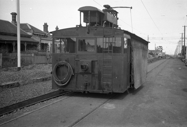
 Ballarat Tramway Museum
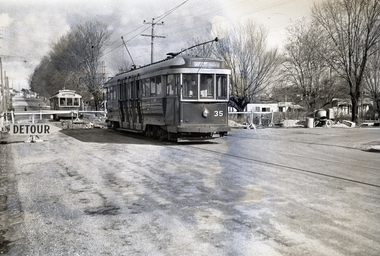
Negative, Wal Jack, Jul. 1955
Yields information about tram services during the reconstruction of the Canadian Creek bridge on the Mt Pleasant line during 1955.Negative and Digital images of the Wal Jack Ballarat Negative file of No. 35 at the Barkly St bridge work at Canadian Creek bridge in Barkly St, Mt Pleasant during the reconstruction of the bridge, during June-July 1955, Has No. 35 providing the connecting service to the City and Drummond St North. No. 32 waits on the other side of the bridge. See Reg items 5157 and 5305 for other associated photos.trams, tramways, mt pleasant, canadian creek, barkly st, bridges, tram 32 tram 35 -
 Melbourne Tram Museum
Negative - Set of 2, Wal Jack, 17/05/1942 12:00:00 AM
Set of two Black and white negatives, by Wal Jack, of rail grinder No. 2 parked in Ascot Vale Road, Moonee Ponds during the construction of the connecting line between Moonee Ponds and Union St and Maribyrnong Road corner. The west line has been completed and the eastern line is under construction. Photo dated 17-5-1942 in the Wal Jack album along with details of the location and the tramcar.trams, tramways, trackwork, new tramway, work trams, ascot vale road, moonee ponds, grinder, tram 2 -
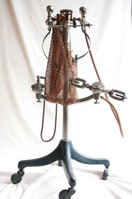 Geoffrey Kaye Museum of Anaesthetic History
Equipment - McKesson Apparatus Model G, sectioned, McKesson Appliance Co, c. 1919
The apparatus sits on a four-legged stand with castors. There is a fabric mesh bag affixed to the top of the apparatus which hangs down half the length of the stand. There are two metal arms protruding out from halfway down the length of the stand; one of the arms has a rubber tube attached to it and the other has a fine braided rope, both of which connect to the top of the apparatus. The top of the apparatus has been sectioned.anaesthesia, rebreathing, carbon dioxide, ether, oxygen -
 Ballarat Tramway Museum
Photograph - Colour Print/s - set of 9, 29/09/1972 12:00:00 AM
Set of nine colour prints of the drainage works and initial track construction carried out by the BTPS outside the depot on 29/9/1972. Photos with hand written captions on rear. .1 - Drainage works No. 2 Road, BTPS Depot .2 - ditto .3 - ditto .4 - ditto .5 - ditto, working in the pit by the level crossing .6 - Drivers eye view from Car 27, No. 2 road construction commencing - sleepers laid out with rail alongside. .7 - Construction of No. 2 road BTPS depot proceeds .8 - Time: 5.46 3/4 - Subject "The first blow" R. Gilbert, Sec BTPS drives the first "doggie" on the track connecting No. 2 road of the depot to Wendouree Parade. .9 - Time: 5.47pm. Subject: R. Gilbert, Sec BTPS drives the first doggie on the track connecting the depot to Wendouree Parade. Picture take of the first "doggie" being driven home.In ink on rear of each photo "23/9/72" and details - see abovetrams, tramways, depot, construction, gardens, buildings, btps -
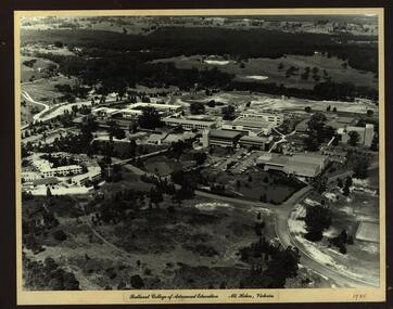 Federation University Historical Collection
Photograph - Photograph - Black and White, Ballarat College of Advanced Education, Mt Helen - 1985, 1985
Photograph of the early years of the Ballarat College of Advanced Education at Mt Helen. On the left is the first stage of the student accommodation with a bridge connecting it to the campus. The car park located near the lakes is next to the Physical Education building. This is before the swimming pool has been added. The building with large white external structure is the E.J.Barker Library before the top floor has been built. This floor is where the Geoffrey Blainey Research Centre is housed.Photograph mounted on heavy white card which is then mounted onto black board. Aerial photograph of Ballarat College of Advanced Education at Mt Helen.ballarat college of advanced education, student accomodation, physical education, swimming pool, e j barker library, geoffrey blainey research centre, student residences -
 Ballarat Tramway Museum
Document - Instruction, Westinghouse Electric & Manufacturing Co, "Parts of Westinghouse Type 1C Tramway Controllers", c1909
Westinghouse part catalogue for their T1C tramway controller style number 15948, undated, possibly c1909 given a number on the bottom left-hand corner of the first sheet. Gives images and a list of all the parts including smaller images in the controller and their prices along with the part number. Published in the UK by The British Westinghouse Electric & Manufacturing Co. Ltd. London and Manchester. Shows both main drum and brake drum development, that is the connecting strips or contacts.Yields information about the Westinghouse UK products.Manual or document 16 printed pages centre stapled within card covers.tramways, tramcars, equipment, westinghouse, maintenance, instructions, controllers -
Frankston RSL Sub Branch
Recorder, Camera
This is a Camera Gun Recorder used in conjunction with a Gyro Gun Sight type 14A, G. G. S. Recorder Mk2 contained in a wooden box with hinged lid and retaining catch. The recorder consists of a metal enclosure with an electrical power supply cable fitted with a three pole female plug connector. A small access cover in the enclosure can be opened to replace the Recorder Magazine. There is a transparent aperture window on the underside of the enclosure.The recorder enclosure is inscribed with the Department of Defence mark and the following, "14A/3629, G.G.S., RECORDER, Mk2, 24V., XX 12012". There are small controls on the narrow side of the recorder which are marked "START, 0, 5, 10, 15, END" and "DULL, S.S. BRIGHT". The recorder magazine is inscribed with the Department of Defence mark and the following "14A/4008, G.G.S., RECORDER, MAGAZINE, MKII". raaf, royal australian air force, gun, fighter, photography, ww2, world war 2, camera, aircraft, bomber, aerial -
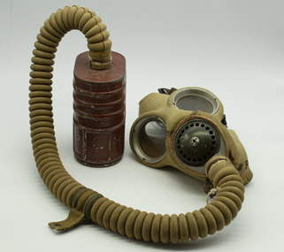 Ballarat RSL Sub-Branch Inc.
Memorabilia - Gas Mask, 1939
WW2 General Service Respirator (GSR) Gas Mask WWII made in 1939 and the Canister was made 1941. Mask made of black rubber with glass eye slots with metal rims. Metal nost piece. Covered in khaki fabric. Elasticized straps to hold mask in place, with a tan circular cloth covered rubber tube that connects to the canister. Tin canister is oval shaped reinforced with ridges, red/brown in colour.Back of mask: N-4II / ML M MAY 39gas mask, equipment, gas warfare, second world war, world war two, world war ii, mustard gas, chemical warfare -
 Melbourne Tram Museum
Ephemera - Timetable/s, Victorian Railways, "Tram Timetables - St Kilda - Elwood Depot", Jul. 1957
Victorian Railways St Kilda Station to Elwood Depot timetable, printed on card that could be folded, providing details of tram times leaving St Kilda Station for Dickens and Vautier Streets or Elwood Depot and return. Advises which trams does not connect with trains. Gives running times and Section Details. Dated 15/7/1957. VR Printed 2484-57 on manila colour card. 8 Copies held..trams, tramways, vr, victorian railways, st kilda, elwood depot, timetables, melbourne -
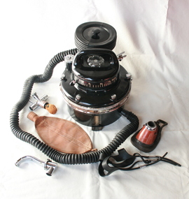 Geoffrey Kaye Museum of Anaesthetic History
Machine - Oxford vaporiser
This vaporiser is enclosed in a portable black cylindrical bakelite carry case with moulded handle, woven fabric strap and single steel latch. The item comprises a three-chambered vaporiser, an assortment of attachments including black ribbed rubber tubing, light brown rubber rebreather bag, facemask, black rubber mask harness, Connell pharyngeal airway with connector, an attachment for an endotracheal or nasal tube, as well as spare thermometer and other parts.Stencilled in white paint on the outside top lid is 'THIS SIDE UP / WITH CARE / SEE INSTRUCTIONS / INSIDE LID'. Serial number is inscribed on metal plate inside the lid and printed in white on the inside lid is 'IMPORTANT / The Oxford Vaporiser is a scientific apparatus'vaporiser, oxford, anaesthetic, portable, bakelite, connell pharyngeal airway, heated vapor, endotracheal, nasal, rebreather bag, thermometer, facemask -
 Bendigo Historical Society Inc.
Map - HUSTLER'S REEF & HUSTLER'S REEF NO 1 MINES - PLAN OF THE HUSTLER'S REEF & HUSTLER'S REEF NO 1 MINES
Plan of the Hustler's Reef & Hustler's Reef No 1 Mines on the Hustler's Line of Reefs, Bendigo Bulletin No 33, Plate No XVI. Plan shows the two shafts and the levels in relation to it. No 9 Level 896 feet 9 inches connecting No 10 Level at 867 feet 2 inches. Plan shows depth of levels and geographical features. Signed by H A Whitelaw, Underground Survey Office, Bendigo. Geographical Survey of Victoria emblem.mining, parish map, hustler's reef & hustler's reef no 1 mines, hustler's line of reefs, h a whitelaw, underground survey office bendigo, geographical survey of victoria -
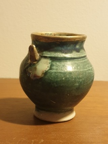 Ballarat Heritage Services
Ceramic, John O'Loughlin, Ceramic vessel by John O'Loughlin, c2019
John O'LOUGHLIN After retiring in 2001 at the age of 58 John O'Louhlin studied Ceramics at the University of Ballarat. The spiritual is evident in his work whose ceramic artworks engage with the way in which organised religion, specifically the Catholic Church, deals with the translation of the spiritual into the material. Informed by his extensive travels and studies, O’Loughlin’s ceramics reference the reliquaries and church artefacts that connect the life of this world with that of faith in another world. He completed a Master of Arts [By Research] Degree.Photograph of a green glazed pot by John O'Loughlin, win an impressed studio stamp on the base..pottery, john o'loughlin, ceramics -
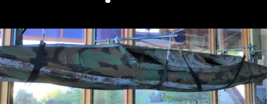 Queenscliffe Maritime Museum
Vehicle - Kayak, Commandos
The remarkable story when 74 soldiers fought in vain to save the lives of their mates off Portsea as 3 soldiers died. Tragically, Privates Roger Wood and Edward Meyer, and Warrant Officer George "Taffy" Drakopoulos, died. Please Note: "The Rip" is also known as "The Heads", which is a dangerous stretch of water connecting Port Phillip Bay and Bass Strait. This is the only entrance for all shipping into Port Phillip Bay and to and from the Port of Melbourne, Victoria, Australia.Kayak of a similar type as those used during the ill-fated army exercise with loss of life in the rip.rip disaster, commandos, kayak, military history - army