Showing 524 items
matching department of lands
-
 Bendigo Historical Society Inc.
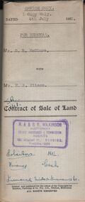
Document - H.A. & S.R. WILKINSON COLLECTION: CONDITION OF SALE
... Department of lands and survey, copy of the right to occupy land... 60 pounds. Also attached various receipt from Department ...Contract of sale of land dated 4th July, 1952 between Mr. D. R. McClure (seller) and Mr.. H. A. Pitson for land described in right to occupy residence area No. 9508, together with all buildings and erection thereon, also all sundries inside and outside the building. Price 60 pounds. Also attached various receipt from Department of lands and survey, copy of the right to occupy land issued in 1942, letter from the City of Bendigo dated in 1951 drawing attention to unpaid rates on the property.organization, business, h.a. & s.r wilkinson real estate -
 Bendigo Historical Society Inc.
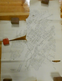
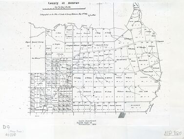
Document - MARKS COLLECTION: PLAN OF SANDHURST CITY CENTRE AND SURROUNDING AREA ( NO. 1 )
... . On bottom lithographed at the Department of Lands and Survey... at the Department of Lands and Survey, Melbourne, by D. Henerson, March 12th ...Plan on heavy parchment - section neatly cut out of area now Kennington. Written on plan in black print ' Sheet No. 1. Sandhurst'. Plan shows Government Camp, Commissioner's Gully, old cemetery site, manure depot, cattle market, Benevolent Asylum Reserve, railway reserve. Landowners' names on allotments. On bottom lithographed at the Department of Lands and Survey, Melbourne, by D. Henerson, March 12th., 1867 Plan part of George Lansell, Fortuna auction, documents found in wardrobe purchased by Marks family in 1930's.bendigo, planning, sandhurst 1867 -
 Clunes Museum
Photograph
... LANDS DEPARTMENT COLOURED PHOTOGRAPH - CLEARING AREA ALONG... history photography photographs clunes landscape LANDS DEPARTMENT ...LANDS DEPARTMENT COLOURED PHOTOGRAPH - CLEARING AREA ALONG CREEK TO MAKE PICNIC AREAlocal history, photography, photographs, clunes landscape -
 University of Melbourne, Burnley Campus Archives
Plan, Plan of Richmond Park, 1886-1948
... , "Department of Lands and Survey Photographed at the Central Plan...". Stamp, "Department of Lands and Survey Photographed ...(1) Black and white photographed copy of an original coloured plan. Plan of Richmond Park with Horticultural Society Gardens marked in. Includes additional land which became the Field Station. Original plan dated 31 August 1872, note of Crown Grant to the Board of Land & Works and Richmond City Council 1886; showing land, "Permanently Preserved for the Gardens". Stamp, "Department of Lands and Survey Photographed at the Central Plan Office 1/1 Plate 7.12.48" (2) Also 2 photocopies, 1 reduced - possibly used in a publication1 photocopy has "Figure 1. Plan of Burnley Gardens circa 1863 [sic]gardens, richmond, horticultural society of victoria, richmond park, a.l. martin -
 Ringwood and District Historical Society
Archive, Lands Department Field Notes, Ringwood 1878-1955 (Parent Record)
... Lands Department Field Notes, Ringwood 1878-1955 (Parent... "Lands Department - Survey of Field Notes of Ringwood Area".... for contents of folder "Lands Department - Survey of Field Notes ...This record is the Parent Record for contents of folder "Lands Department - Survey of Field Notes of Ringwood Area". -
 Bendigo Historical Society Inc.
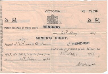
Document - Mining in Bendigo, 1909 to 1939
... victorian lands department and closer settlement commission... Gully 8663.3d Receipt from the Lands Department and Closer... victorian lands department and closer settlement commission albert e ...BHS CollectionDocuments related to Mining in Bendigo, purchase of a property. 8663.3a Front of Miners Right issued to Robinson Fairbairn 8663.3b Back of Miners Right issued to Robinson Fairbairn 8663.3c Valuation from Shire of Marong, 14 Bray St., California Gully 8663.3d Receipt from the Lands Department and Closer settlement Commission 8663.3e Receipt from the Lands Department and Closer settlement Commission 8663.3f Receipt from the Lands Department and Closer settlement Commission 8663.3g Receipt from the Lands Department 8663.3h Receipt from Albert E. Brown Land and Stock Agenthistory, mining, robinson fairbairn collection, miners right, victorian lands department and closer settlement commission, albert e brown land and stock agent -
 University of Melbourne, Burnley Campus Archives
Plan, Wilsons Promontory8119-I and Glennie 8119-IV, 1971
... Photography for the Department of Crown Lands and Survey Victoria... Photography for the Department of Crown Lands and Survey Victoria ...State Aerial Survey Plan of Wilsons Promontory and Glennie. Dated 1971. Provisional Compilation of Sheets 8119-I and 8119-IV from Commonwealth Department of National Development Photography for the Department of Crown Lands and Survey Victoria. Students made excursions to Wilsons Promontory.wilsons promontory, glennie group, anser group, bass strait, aerial survey -
 Whitehorse Historical Society Inc.
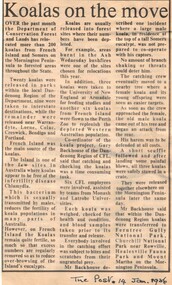
Article, Koalas on the move, 14/01/1986 12:00:00 AM
... victoria. department of conservation forests and lands... of koalas by the Department of Conservation, Forests and Lands.... Mitcham melbourne wildlife koalas victoria. department ...Article from 'The Post' 14 January 1986 about relocation of koalas by the Department of Conservation, Forests and Lands.Article from 'The Post' 14 January 1986 about relocation of koalas by the Department of Conservation, Forests and Lands.Article from 'The Post' 14 January 1986 about relocation of koalas by the Department of Conservation, Forests and Lands.wildlife, koalas, victoria. department of conservation forests and lands -
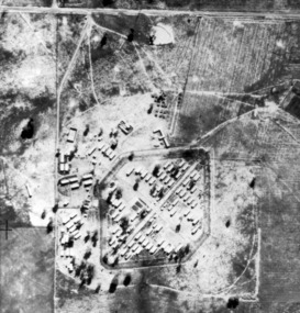 Tatura Irrigation & Wartime Camps Museum
Photograph, early to mid 1940's
... Obtained from State Governmant Lands Department.... Tatura the-murray Obtained from State Governmant Lands Department ...Obtained from State Governmant Lands Department.Black and white photo of camp 4 compound.aerial photo of camp4, japanese family camp, photo taken in 1946 -
Whitehorse Historical Society Inc.
Document, Crown Grant Register, 10/05/1999
... Victoria. Lands Department..., 1854 - 1858. Lands Department plan of Parish, 1864.... Mitcham melbourne Land Settlement Victoria. Lands Department Blood ...Crown Grant Register - General Law - Parish of Nunawading, 1854 - 1858. Lands Department plan of Parish, 1864.land settlement, victoria. lands department, blood, robert, blood, thomas, burrell, charles, clisby, william, cook, charles, cousens, james, dickensen, william, harding, william, hedding, william, holland, john, jones, william, kefford, richard, lobb, john, morgan, robert rowland, morton, william, o'conner, patrick, orr, joseph, polak, nelson, riley, patrick, smith, l l dr, tranter, william, whitman, francis, williams, william, wilks, joseph, wilson, william, wilton, edward -
 Whitehorse Historical Society Inc.
Map - Nunawading scaled Map, Nunawading, 1864
... Parish plan of Nunawading, Lands Department, 1864, showing... plan of Nunawading, Lands Department, 1864, showing names ...Parish plan of Nunawading, Lands Department, 1864, showing names of first purchasers of land. Copy also at NP215.parish of nunawading, land settlement, maps -
 Bendigo Historical Society Inc.
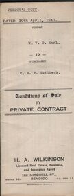
Document - H.A & S.R. WILKINSON COLLECTION: CONTRACT OF SALE
... . Attached 5 receipt issued by Department of Lands and Survey plus 2... and troughs. Price 175 pounds. Attached 5 receipt issued by Department ...Conditions of sale by private sale dated 10th April, 1940 between W.V.O. Earl (seller) and C.M.F. Skilbeck (buyer) for land situate No.148 Booth Street, Bendigo, being the land described in right to occupy residence area No.4501. Also all the vendor's right, title and interest in that piece of land adjoining the above mentioned land described in permissive occupancy title no. W.52845, together with 5-roomed weatherboard dwelling and all sundry. Also bath, copper and troughs. Price 175 pounds. Attached 5 receipt issued by Department of Lands and Survey plus 2 receipt from City of Bendigo for rates. Vendor's copy.organization, business, h.a. & s.r wilkinson real estate -
 Wodonga & District Historical Society Inc
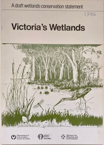
Book - Victoria's Wetlands, Dept. of Conservation, Forests & Lands, 1986
... & Lands, Department of Water Resources, Victoria, Ministry... of Conservation, Forests & Lands, Department of Water Resources, Victoria ...This publication was the result of an inquiry into the state of wetland environments in Victoria. It produced a draft strategy for conservation of threatened areas in the future.An 22 page book containing maps and illustrationsThis publication was the result of an inquiry into the state of wetland environments in Victoria. It produced a draft strategy for conservation of threatened areas in the future.wetland protection, wetlands victoria, water conservation -
 Warrnambool and District Historical Society Inc.
Document and covering letter, Augustus Bostock, 1883
... Department of Public Lands, Pastoral Occupation Branch. ... with Wilson Bro & Co in top RH corner. 000849.2 Department of Public ...Augustus Bostock was the 9th child of Robert & Rachael Bostock of Vaucluse Epping Forest, Van Diemen’s Land. He was only 4 years old when his mother died. He was inspired by his father to seek his fortune in the Western District of Victoria. He arrived around 1850. He married Margaret Aitkin in July 1865. Augustus owned several properties in the district and leased others. He sat on the court of Warrnambool, Mortlake or Hexham as required. He resided at Marramook in Hawkesdale and later moved to Vaucluse in Hopetoun Road Warrnambool, where he died in 1920 at the age of 87. He was involved in many aspects of life in the Western District, racing, cricket, and social activities to name a few. This document relates to lease of land at Talawanta in Northern NSW This is one of a number of documents which relate to the Bostock family who were one of the most important pioneering families of the Western District. They owned and leased various properties around Warrnambool and were involved in many aspects of social and business life. The document itself is indicative of its time and provides an insight into the details and terms of such documents at the time.000849.1 Handwritten letter on lined paper with The business details printed at the top and purple stamp near signature at the end of letter. Back is blank. 000849.2 Blue foolscap size paper document with outline printed with details handwritten in black ink. 000849.1 signed Gillin Wilson. The Queensland Mercantile & agency Co in red with Wilson Bro & Co in top RH corner. 000849.2 Department of Public Lands, Pastoral Occupation Branch. warrnambool, bostock, augustus bostock, bostock,talawanta,1883, -
 Warrnambool and District Historical Society Inc.
Document and covering letter, Augustus Bostock, 1883
... Department of Public Lands, Pastoral Occupation Branch. ... in red with Wilson Bro & Co in top RH corner. 000850.2 Department ...Augustus Bostock was the 9th child of Robert & Rachael Bostock of Vaucluse Epping Forest, Van Diemen’s Land. He was only 4 years old when his mother died. He was inspired by his father to seek his fortune in the Western District of Victoria. He arrived around 1850. He married Margaret Aitkin in July 1865. Augustus owned several properties in the district and leased others. He sat on the court of Warrnambool, Mortlake or Hexham as required. He resided at Marramook in Hawkesdale and later moved to Vaucluse in Hopetoun Road Warrnambool, where he died in 1920 at the age of 87. He was involved in many aspects of life in the Western District, racing, cricket, and social activities to name a few. This document relates to transfer of land at Talawanta, lots 10, 11 and 12 in Northern NSW as well as Morell, and Rippledon. This is one of a number of documents which relate to the Bostock family who were one of the most important pioneering families of the Western District. They owned and leased various properties around Warrnambool and were involved in many aspects of social and business life. The document itself is indicative of its time and provides an insight into the details and terms of such documents at the time.000850.1 Handwritten letter on lined paper with The business details printed at the top and purple stamp near signature at the end of letter. Back is blank. 000850.2 Blue foolscap size paper document with outline printed with details handwritten in black ink. 000850.1 signed R Newtown. The Queensland Mercantile & agency Co in red with Wilson Bro & Co in top RH corner. 000850.2 Department of Public Lands, Pastoral Occupation Branch. warrnambool, bostock, james bostock, augustus bostock, peter manifold, 1883,morell,rippledon, talawanta, anthony mackenzie, archibald campbell eddington, albert edwin whiting, grace beveridge mackenzie, -
 Bendigo Historical Society Inc.
Map - FRED COWIE COLLECTION: AERIAL MAPS OF HEATHCOTE/EPPALOCK, 28-9-1960
... of Victoria. Photo-map prepared by Department of Crown Lands...-map prepared by Department of Crown Lands and Survey from ...Map, Heathcote C2, Township of Heathcote, Melbourne Road through town branching off to Bendigo & Echuca. Aerial Survey of Victoria. Photo-map prepared by Department of Crown Lands and Survey from photographs taken in 1960. Copied photographically at the Central Plan Office.Fred Cowie,46 McIvor Rd,Bgo..Central Plan Officemap, heathcote, fred cowie -
 Bendigo Historical Society Inc.
Map - FRED COWIE COLLECTION: AERIAL MAPS OF HEATHCOTE/EPPALOCK, 28-9-60
... prepared by Department of Crown Lands and Survey from photographs... by Department of Crown Lands and Survey from photographs taken in 1960 ...Map, Heathcote C4, Aerial Survey of Victoria,Photo-map prepared by Department of Crown Lands and Survey from photographs taken in 1960. Copied photographically at the Central Plan Office.Date 28-9-60,C.P.O.Neg.No.21590.Scale 4 inches to 1 mile. Fred Cowie,46 McIvor Rd,Bgo..Central Plan Office.map, heathcote, fred cowie -
 St Kilda Historical Society
Photograph - Photo map, 28/01/1951
... One of a series of photo-maps produced for the Department... produced for the Department of Crown Lands and Survey (1857-1983 ...One of a series of photo-maps produced for the Department of Crown Lands and Survey (1857-1983). For correlation with a current map, and access to other historical photo maps of Victoria, see the Historic Photo-Maps Index published by the Department of Environment, Land, Water and Planning at https://services.land.vic.gov.au/DELWPmaps/historical-photomaps/Black and white aerial photograph1424-45 SECRET 534 Run 18 Lens 12" Melbourne Metropolitan 12150 28.1.51 M639albert park, st kilda junction, st kilda pier, catani gardens, st kilda, prahran, albert park lake, 1951, middle park, st kilda beach, windsor -
 St Kilda Historical Society
Photograph - Photo map, 17/01/1951
... One of a series of photo-maps produced for the Department... produced for the Department of Crown Lands and Survey (1857-1983 ...One of a series of photo-maps produced for the Department of Crown Lands and Survey (1857-1983). For correlation with a current map, and access to other historical photo maps of Victoria, see the Historic Photo-Maps Index published by the Department of Environment, Land, Water and Planning at https://services.land.vic.gov.au/DELWPmaps/historical-photomaps/Black and white aerial photograph1414-21 538 Run 19 Lens 12" Melbourne Metropolitan 12150 17.1.51 M586st kilda, st kilda botanical gardens, peanut farm, elwood, 1951, point ormond, elwood canal, st kilda beach -
 St Kilda Historical Society
Photograph - Photo map, 28/01/1951
... One of a series of photo-maps produced for the Department... produced for the Department of Crown Lands and Survey (1857-1983 ...One of a series of photo-maps produced for the Department of Crown Lands and Survey (1857-1983). For correlation with a current map, and access to other historical photo maps of Victoria, see the Historic Photo-Maps Index published by the Department of Environment, Land, Water and Planning at https://services.land.vic.gov.au/DELWPmaps/historical-photomaps/Black and white aerial photograph1424-118 534 Run 20 Lens 12" Melbourne Metropolitan 12150 18.1.51M639elwood, point ormond, elwood park, elsternwick park, elwood beach, 1951 -
 St Kilda Historical Society
Photograph - Photo map, 17/01/1951
... One of a series of photo-maps produced for the Department... produced for the Department of Crown Lands and Survey (1857-1983 ...One of a series of photo-maps produced for the Department of Crown Lands and Survey (1857-1983). For correlation with a current map, and access to other historical photo maps of Victoria, see the Historic Photo-Maps Index published by the Department of Environment, Land, Water and Planning at https://services.land.vic.gov.au/DELWPmaps/historical-photomaps/Black and white aerial photograph1414-20 538 Run 19 Lens 12" Melbourne Metropolitan 12150 17.1.51 M586elwood, elsternwick, st kilda east, balaclava, ripponlea, 1951 -
 St Kilda Historical Society
Photograph - Photo map, 28/01/1951
... One of a series of photo-maps produced for the Department... produced for the Department of Crown Lands and Survey (1857-1983 ...One of a series of photo-maps produced for the Department of Crown Lands and Survey (1857-1983). For correlation with a current map, and access to other historical photo maps of Victoria, see the Historic Photo-Maps Index published by the Department of Environment, Land, Water and Planning at https://services.land.vic.gov.au/DELWPmaps/historical-photomaps/Black and white aerial photograph1424-44 534 Run 18 Lens 12" Melbourne Metropolitan 12150 28.1.51 M639 -
 St Kilda Historical Society
Photograph - Photo map, 28/01/1951
... One of a series of photo-maps produced for the Department... produced for the Department of Crown Lands and Survey (1857-1983 ...One of a series of photo-maps produced for the Department of Crown Lands and Survey (1857-1983). For correlation with a current map, and access to other historical photo maps of Victoria, see the Historic Photo-Maps Index published by the Department of Environment, Land, Water and Planning at https://services.land.vic.gov.au/DELWPmaps/historical-photomaps/Black and white aerial photograph1424-43 534 Run 18 Lens 12" Melbourne Metropolitan 12150 28.1.51 M639armadale, malvern, st kilda cemetery, caulfield north, st kilda east, 1951 -
 St Kilda Historical Society
Photograph - Photo map, 30/01/1960
... One of a series of photo-maps produced for the Department... produced for the Department of Crown Lands and Survey (1857-1983 ...One of a series of photo-maps produced for the Department of Crown Lands and Survey (1857-1983). For correlation with a current map, and access to other historical photo maps of Victoria, see the Historic Photo-Maps Index published by the Department of Environment, Land, Water and Planning at https://services.land.vic.gov.au/DELWPmaps/historical-photomaps/Black and white aerial photographVic 1093-62 Melbourne & Metropolitan Project Run 21 30.1.60 Lens 10" 8.200middle park, albert park, catani gardens, st kilda west, 1960 -
 St Kilda Historical Society
Photograph - Photo map, 30/01/1960
... One of a series of photo-maps produced for the Department... produced for the Department of Crown Lands and Survey (1857-1983 ...One of a series of photo-maps produced for the Department of Crown Lands and Survey (1857-1983). For correlation with a current map, and access to other historical photo maps of Victoria, see the Historic Photo-Maps Index published by the Department of Environment, Land, Water and Planning at https://services.land.vic.gov.au/DELWPmaps/historical-photomaps/Black and white aerial photographVic 1093-60 Melbourne & Metropolitan Project Run 21 30.1.60 Lens 10" 8.200st kilda, albert park, prahran, windsor, south yarra, 1960 -
 St Kilda Historical Society
Photograph - Photo map, 30/01/1960
... One of a series of photo-maps produced for the Department... produced for the Department of Crown Lands and Survey (1857-1983 ...One of a series of photo-maps produced for the Department of Crown Lands and Survey (1857-1983). For correlation with a current map, and access to other historical photo maps of Victoria, see the Historic Photo-Maps Index published by the Department of Environment, Land, Water and Planning at https://services.land.vic.gov.au/DELWPmaps/historical-photomaps/Black and white aerial photographVic 1092-36 Melbourne & Metropolitan Project Run 22 30.1.60 Lens 10" 8.200st kilda, st kilda pier, st kilda beach, catani gardens, 1960 -
 St Kilda Historical Society
Photograph - Photo map, 30/01/1960
... One of a series of photo-maps produced for the Department... produced for the Department of Crown Lands and Survey (1857-1983 ...One of a series of photo-maps produced for the Department of Crown Lands and Survey (1857-1983). For correlation with a current map, and access to other historical photo maps of Victoria, see the Historic Photo-Maps Index published by the Department of Environment, Land, Water and Planning at https://services.land.vic.gov.au/DELWPmaps/historical-photomaps/Black and white aerial photographVic 1092-38 Melbourne & Metropolitan Project Run 22 30.1.60 Lens 10" 8.200st kilda, st kilda beach, st kilda pier, catani gardens, 1960, st kilda botanical gardens, peanut farm -
 St Kilda Historical Society
Photograph - Photo map, 30/01/1960
... One of a series of photo-maps produced for the Department... produced for the Department of Crown Lands and Survey (1857-1983 ...One of a series of photo-maps produced for the Department of Crown Lands and Survey (1857-1983). For correlation with a current map, and access to other historical photo maps of Victoria, see the Historic Photo-Maps Index published by the Department of Environment, Land, Water and Planning at https://services.land.vic.gov.au/DELWPmaps/historical-photomaps/Black and white aerial photographVic 1092-40 Melbourne & Metropolitan Project Run 22 30.1.60 Lens 10" 8.200st kilda east, balaclava, ripponlea, st kilda cemetery, 1960 -
 St Kilda Historical Society
Photograph - Photo map, 30/01/1960
... One of a series of photo-maps produced for the Department... produced for the Department of Crown Lands and Survey (1857-1983 ...One of a series of photo-maps produced for the Department of Crown Lands and Survey (1857-1983). For correlation with a current map, and access to other historical photo maps of Victoria, see the Historic Photo-Maps Index published by the Department of Environment, Land, Water and Planning at https://services.land.vic.gov.au/DELWPmaps/historical-photomaps/Black and white aerial photographVic 1092-42 Melbourne & Metropolitan Project Run 22 30.1.60 Lens 10" 8.200malvern, caulfield, caulfield park, 1960 -
 St Kilda Historical Society
Photograph - Photo map, 30/01/1960
... One of a series of photo-maps produced for the Department... produced for the Department of Crown Lands and Survey (1857-1983 ...One of a series of photo-maps produced for the Department of Crown Lands and Survey (1857-1983). For correlation with a current map, and access to other historical photo maps of Victoria, see the Historic Photo-Maps Index published by the Department of Environment, Land, Water and Planning at https://services.land.vic.gov.au/DELWPmaps/historical-photomaps/Black and white aerial photographVic 1091-112 Melbourne & Metropolitan Project Run 23East 30.1.1960 Lens 10" 8.200elwood, point ormond, elwood park, elwood canal, 1960