Showing 488 items matching "first survey"
-
 Moorabbin Air Museum
Manual (Item) - AGARD Survey Panel Flutter, AGARD A Survey on Panel Flutter by D.J.Johns
NATO -
Moorabbin Air Museum
Book (Item) - Flight Aviation Engines , A General Survey Of Fundamentals Of Aviation, Flight Aviation Engines
By Ray F.Kuns -
Moorabbin Air Museum
Document (Item) - Bell Helicopter Company Technical Data Model 47G-3B-1 Load Level Survey
Report No. 47-980-183 Dated 19.10.1962 -
Moorabbin Air Museum
Book (Item) - Flight - Meteorology and Aircraft Instruments - General Survey of Fundamentals of Aviation by Wright Dyer and Martin
-
Moorabbin Air Museum
Book (Item) - A survey of instrument parts - Fluid Film Bearings by PJ Geary
-
Moorabbin Air Museum
Document (Item) - Ansett Documents Relating To Survey Of Royal Hayman Hotel Hayman Island Great Barrier Reef, Ansett Documents
-
Moorabbin Air Museum
Booklet (Item) - DeHavilland Domestic Airline Survey, J. M. Warner, Australian Domestic Airline Survey: The Geoffrey de Havilland Memorial Lecture 1979, 1979
Contains de Havilland's assessment of the history, present position and future of the Australian domestic aviation industry. Presented as a lecture. -
Moorabbin Air Museum
Document (Item) - Ansett Correspondence Relating To South Pacific Trip For The Purpose Of Surveying Flights For Future Tourist Charter Trips Accommodation Tourist Attractions, Ansett Correspondence
-
Moorabbin Air Museum
Document (Item) - US War Department Air Corps Flutter Survey of two radio antenna
-
Moorabbin Air Museum
Drawing (Item) - Survey Helicopter (Sioux) - Assembly Drawing No. ADE(X)731-257
... Moorabbin Air Museum Moorabbin Airport 12 First Street ... -
Moorabbin Air Museum
Booklet - SURVEY OF ACCIDENTS TO AUSTRALIAN CIVIL AIRCRAFT 1988
... Moorabbin Air Museum Moorabbin Airport 12 First Street ... -
Moorabbin Air Museum
Document (Item) - Fairey Surveys Technical Report on work completed in developing a second system for the provision of Graticule Illumination on a Mk 1B camera fitted with rear facing lens
-
Moorabbin Air Museum
Document (Item) - GAF Projects B and C Specification E7/48 Design Survey No 3 - Jindivik
-
Moorabbin Air Museum
Letter (Item) - AARG MAM Random Proforma Documents for Management covering membership objectives strategies election paraphenalia work survey
-
Moorabbin Air Museum
Document (item) - CA-15 Emergency procedures during flight Survey of commercial pilots metal fatigue Die penetrants HPR3 Handley Page performance and design details Boeing A300 B767 Turkish airline DC10 crash 3 march 1974 Avro Anson Nomad N24A high speed flight WW1 Australian pilots Australian aircraft registration Aermacchi MB-326H Jim Bede CAC Wallaby ESAMS remote piloted helicopter types of British aircraft up to 1918 SR71 U2 Ken Wallis Little Nelly Jean Batten Bob Miles Gypsy Moth Molyneux helicopter CA 25 FLUT-R-Bug Chipmunk Chris Neale Perfectus Ellis Walker New Comet Beagle Landing areas in Australia Fishermans Bend airport Southern Cross Southern Cross Junior Akro Laser Short Scion Pierpont Langley Jeep plane Homebuilt plane criteria R33 R101 R100 Graf Zeppelin Corrosion DEF Aust 143 Weight control of aircraft DCA No.17 Airtruck F14 B-1 F-4 F-15 A-6 F-16 F/A-18 CH-53E AH-64 A-10 F-5 Space Shuttle Winjeel DC-3 Her Majesty the Queen ME 410 Nestler Scout Bellmodel 214 Loire 11 Schweizer model 300 Antonov An-8 camp Nanchang cj-6 Nieuport de Lage ni-D.122 Junker K 39 ICA Brasov IAR-823 Les Mureaux 120 F&W C-3603 Spitfire Lockheed C-36 Pilatus PC-6 Heinkel He 115 Canadair CL-215 Curtiss JN-4 Jenny Antonov An-2 colt Boeing KC-135 Stuka Liberator B-52 Morane Saulnier Bf-109 Dewoitine Yak-3 F-5 KFIR F-100 B-1B B-25 B-17 Fokker D VII Mustang F-16 Aeritalia Aermacchi Fishbed Mikoyan Hawker Hunter PZL P.11 Yakovlev Yak-11 Dassault Alpha jet Westland Lynx Magni PM-3-4 Letov S 50 Partenavia P.64 Piaggio P.149D Breda Ba 64 Aerotec A-122 Farman F.40 McCulloch H-30 Junkers K 53 Cessna U-3 Bf 161, CAC Keith Meggs collection
-
Moorabbin Air Museum
Document (item) - CAC Collection - Historical Review And Survey Of Plant And Production Aspects Of The GAF Engine Factory Lidcombe NSW
Prepared 1st May 1957 -
Moorabbin Air Museum
Manual (item) - CAC Collection Engineering Surveys, Engineering Survey
CAC Collection -
 Bendigo Historical Society Inc.
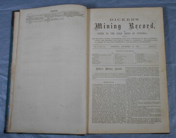
Journal - Dicker's Mining Journal 1862
Thomas Dicker, Rowan Street, Bendigo, published a monthly mining journal that included geological information, mine details and mining practises for particular mining districts. In 1868/9, Dicker moved to England to open the "Australian and London Mining Agency" with the goals of promoting investment in Victorian mines, entering Victorian mining shares on the London Stock market, and exploring the latest in mining technology that might be suitable for mining in Victoria.Dicker's Mining Record and guide to the gold mines of Victoria, showing the bearings, depths, thickness, dips and underlies of the auriferous lodes; the progress and cost of works in operation; containing also a variety of valuable interesting and statistical information. Published by the proprietor, Thomas Dicker, Rowan Street Sandhurst. A green with black spine hardcover book. Paper glued on the front with the title Dicker's Mining Journal 1862. On the spine in gold lettering Dicker's Mining Record Vol.1 1861-2. The book contains 12 issues of the Dicker's Mining Record, the first from Saturday, November 23, 1861: the last from October 24, 1862. Also, there are two pieces of paper inside front cover with writing in pencil; the first says: shaft originally No.3 shaft of the speedwell coy. in 1902 the North Normanby Coy. was formed and took over the shaft. A new winding engine was installed in 1909. 10 head battery 1905, extra 20 head in 1909. The second, also in pencil, reads: Dept. of Mines Geological survey No.4 Ballarat East goldfields - 1907 - Mr. Marbrey (?) 39 Shamrock St. Bendigo.Sticker on inside front page: Ballarat Historical Museum presented by Mr. W.H. Lewis Young Street. On second page in pencil: Mr. John N Bailey mining manager of John Woods mines Stawell, Sons of Freedom Beaufort (illegible). To Mr. John Bailey as a mark of esteem grom J. Logan.dicker's mining journal, 1862, mining -
 Bendigo Historical Society Inc.
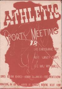
Programme - THE BROOK AND ANDERSON FORTUNA COLLECTION: ATHLETIC SPORTS MEETING
LHQ Cartographic Company, Australian Survey Corps (OC Maj WM Sarll). Athletic sports meeting, Upper Reserve, Bendigo. Monday 31stJanuary 1944, first event at 12.45pm Eight pages listing all the events and the participants.military, world war 2 -
 Bendigo Historical Society Inc.
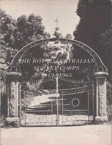
Booklet - THE BROOK AND ANDERSON FORTUNA COLLECTION: ROYAL AUSTRALIAN SURVEY CORPS 1915-1965
Small booklet titled: the Australian Survey Corps 1915-1965. On the black and white cover a picture of the entry gate at Fortuna villa. On the first page a welcome to the open day at AHQ Svy Regt on Sunday 14 November, 1965 to mark the Jubilee year, after a brief history of the Royal Australian Survey corps and of Fortuna villa, the booklet list all the personnel, black and white photos of Fortuna are included.military, world war 2 -
 Ballarat Tramway Museum
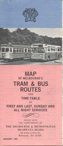
Map, Survey and Mapping for MMTB, "Map of Melbourne's Trams and Bus routes and all night services", Jan. 1967
Fold out sheet coloured map, 12 portions or folds, - title - "Map of Melbourne's Trams and Bus routes and all night services" map shows trams lines, route numbers, terminal points, bus routes, railway lines, blow up of city area with places of interest and key. On rear details, places of interest, suburb index, index to routes, first and last services, Sunday am services, all night bus services and locations of depots and head office. 2nd copy added 11-8-2006. Images of document - scanned to A3 size and overlapping added 30/10/13 On rear "out of date" stamp and 1 "cancelled" stamp - red ink.trams, tramways, melbourne, map, tram & bus services, all night services -
Moorabbin Air Museum
Manual - Field Service Surveys (Winjeel) 1956 - 1964
Historical Details: . Description: Winjeel Defect Reports. Level of Importance: -
Moorabbin Air Museum
Manual - Field Service Surveys - Mirage 540/580/29
Historical Details: . Description: Defect Reports - Mirage 540-580/9. Level of Importance: RAAF -
 Kew Historical Society Inc
Plan, Melbourne & Metropolitan Board of Works : Borough of Kew : Detail Plan No.1576, 1904
The Melbourne and Metropolitan Board of Works (MMBW) plans were produced from the 1890s to the 1950s. They were crucial to the design and development of Melbourne's sewerage and drainage system. The plans, at a scale of 40 feet to 1 inch (1:480), provide a detailed historical record of Melbourne streetscapes and environmental features. Each plan covers one or two street blocks (roughly six streets), showing details of buildings, including garden layouts and ownership boundaries, and features such as laneways, drains, bridges, parks, municipal boundaries and other prominent landmarks as they existed at the time each plan was produced. (Source: State Library of Victoria)This plan forms part of a large group of MMBW plans and maps that was donated to the Society by the Mr Poulter, City Engineer of the City of Kew in 1989. Within this collection, thirty-five hand-coloured plans, backed with linen, are of statewide significance as they include annotations that provide details of construction materials used in buildings in the first decade of the 20th century as well as additional information about land ownership and usage. The copies in the Public Record Office Victoria and the State Library of Victoria are monochrome versions which do not denote building materials so that the maps in this collection are invaluable and unique tools for researchers and heritage consultants. A number of the plans are not held in the collection of the State Library of Victoria so they have the additional attribute of rarity.Original survey plan, issued by the MMBW to a contractor with responsibility for constructing sewers in the area identified on the plan within the Borough of Kew. The plan was at some stage hand-coloured, possibly by the contractor, but more likely by officers working in the Engineering Department of the Borough and later Town, then City of Kew. The hand-coloured sections of buildings on the plan were used to denote masonry or brick constructions (pink), weatherboard constructions (yellow), and public buildings (grey). Development in the 20th century has irreparably altered that part of Kew represented in this plan. In the block bounded by Cotham Road, Charles Street, Wellington Street and Gellibrand; just one house standing in 1903 remains. This block included two of the most historic houses in Kew: ‘Ordsall’ (later ‘Southesk’) and ‘Madford’ (previously ‘Elm Lodge’). Ordsall was the home of the second chairman of Kew, John Halfey. It contained some of the most significant interior murals in Kew, created for Halfey by artists working for Cullen & Co. It was demolished in 1960 to make way for the Kew Civic Centre. Elm Lodge had been built for William Siddeley in ca. 1864. Arthur Septimus King purchased it in 1874. The lower paddocks of Madford were sold in 1905 by his wife to the Borough of Kew and, after landscaping by George and Thomas Pockett, opened as the Alexandra Gardens in 1908. Elm Lodge/Madford was in 1922 to become St. Anthony’s Home for Little Children before its subsequent demolition in the 1980s.melbourne and metropolitan board of works, detail plans, maps - borough of kew, mmbw 1576, cartography -
 Kew Historical Society Inc
Plan, Borough of Kew Detail Plan No.1577, 1904
The Melbourne and Metropolitan Board of Works (MMBW) plans were produced from the 1890s to the 1950s. They were crucial to the design and development of Melbourne's sewerage and drainage system. The plans, at a scale of 40 feet to 1 inch (1:480), provide a detailed historical record of Melbourne streetscapes and environmental features. Each plan covers one or two street blocks (roughly six streets), showing details of buildings, including garden layouts and ownership boundaries, and features such as laneways, drains, bridges, parks, municipal boundaries and other prominent landmarks as they existed at the time each plan was produced. (Source: State Library of Victoria)This plan forms part of a large group of MMBW plans and maps that was donated to the Society by the Mr Poulter, City Engineer of the City of Kew in 1989. Within this collection, thirty-five hand-coloured plans, backed with linen, are of statewide significance as they include annotations that provide details of construction materials used in buildings in the first decade of the 20th century as well as additional information about land ownership and usage. The copies in the Public Record Office Victoria and the State Library of Victoria are monochrome versions which do not denote building materials so that the maps in this collection are invaluable and unique tools for researchers and heritage consultants. A number of the plans are not held in the collection of the State Library of Victoria so they have the additional attribute of rarity.Original survey plan, issued by the MMBW to a contractor with responsibility for constructing sewers in the area identified on the plan within the Borough of Kew. The plan was at some stage hand-coloured, possibly by the contractor, but more likely by officers working in the Engineering Department of the Borough and later Town, then City of Kew. The hand-coloured sections of buildings on the plan were used to denote masonry or brick constructions (pink), weatherboard constructions (yellow), and public buildings (grey). MMBW Plan No.1577 includes some of the most significant houses in Kew: Herbert Henty’s ‘Roxeth’ (now part of Trinity Grammar), ‘Butleigh Wooton’, ‘Bokara’ and ‘Harrow’. It also includes the streets that have since changed their names. That part of College Parade linked to Glenferrie Road is now named College Place, College Parade now extends further north, and Charles Street did not yet reach Barkers Road. Roxeth is one of a number of Henty houses in Kew. Herbert Henty made his home here and was elected a member of Kew Municipal Council in 1864 and mayor in 1868-69. Walter Henry Serle, of Harrow served in the First World War. He was awarded the Military Medal ‘’For conspicuous bravery and devotion to duty. On 29th September near BELLICOURT he showed the greatest bravery and determination when his platoon was attacked by enemy bombing parties. It was due largely to his personal efforts that all the attacks were repulsed. Until wounded, his utter disregard of personal safety and boldness in dealing with the attacks were the means of saving the situation and were an inspiring example to his men.’melbourne and metropolitan board of works, detail plans, maps - borough of kew, mmbw 1577, cartography -
 Kew Historical Society Inc
Plan, Melbourne & Metropolitan Board of Works : Borough of Kew : Detail Plan No.1578, 1904
The Melbourne and Metropolitan Board of Works (MMBW) plans were produced from the 1890s to the 1950s. They were crucial to the design and development of Melbourne's sewerage and drainage system. The plans, at a scale of 40 feet to 1 inch (1:480), provide a detailed historical record of Melbourne streetscapes and environmental features. Each plan covers one or two street blocks (roughly six streets), showing details of buildings, including garden layouts and ownership boundaries, and features such as laneways, drains, bridges, parks, municipal boundaries and other prominent landmarks as they existed at the time each plan was produced. (Source: State Library of Victoria). This plan forms part of a large group of MMBW plans and maps that was donated to the Society by the Mr Poulter, City Engineer of the City of Kew in 1989. Within this collection, thirty-five hand-coloured plans, backed with linen, are of statewide significance as they include annotations that provide details of construction materials used in buildings in the first decade of the 20th century as well as additional information about land ownership and usage. The copies in the Public Record Office Victoria and the State Library of Victoria are monochrome versions which do not denote building materials so that the maps in this collection are invaluable and unique tools for researchers and heritage consultants. A number of the plans are not held in the collection of the State Library of Victoria so they have the additional attribute of rarity.Original survey plan, issued by the MMBW to a contractor with responsibility for constructing sewers in the area identified on the plan within the Borough of Kew. The plan was at some stage hand-coloured, possibly by the contractor, but more likely by officers working in the Engineering Department of the Borough and later Town, then City of Kew. The hand-coloured sections of buildings on the plan were used to denote masonry or brick constructions (pink), weatherboard constructions (yellow), and public buildings (grey). MMBW Plan No.1578 is significant in that it defines the extent of two private schools: Xavier College and Kew High School (now part of Trinity Grammar) by 1904. In relation to the latter, the plan clarifies which buildings the High School operated from behind the mansion ‘Molina’. Established in 1902, Trinity Grammar was to later lease and subsequently buy Molina (now ‘Merritt House’) and ‘Elsinore’ (now ‘Roberts House’). Xavier College had been established in 1872. This 1904 plan delineates the West Wing and the Great Hall (built in 1890).melbourne and metropolitan board of works, detail plans, maps - borough of kew, mmbw 1578, cartography -
 Kew Historical Society Inc
Plan, Melbourne & Metropolitan Board of Works. Borough of Kew Detail Plan No.1579, 1904
The Melbourne and Metropolitan Board of Works (MMBW) plans were produced from the 1890s to the 1950s. They were crucial to the design and development of Melbourne's sewerage and drainage system. The plans, at a scale of 40 feet to 1 inch (1:480), provide a detailed historical record of Melbourne streetscapes and environmental features. Each plan covers one or two street blocks (roughly six streets), showing details of buildings, including garden layouts and ownership boundaries, and features such as laneways, drains, bridges, parks, municipal boundaries and other prominent landmarks as they existed at the time each plan was produced. (Source: State Library of Victoria). This plan forms part of a large group of MMBW plans and maps that was donated to the Society by the Mr Poulter, City Engineer of the City of Kew in 1989. Within this collection, thirty-five hand-coloured plans, backed with linen, are of statewide significance as they include annotations that provide details of construction materials used in buildings in the first decade of the 20th century as well as additional information about land ownership and usage. The copies in the Public Record Office Victoria and the State Library of Victoria are monochrome versions which do not denote building materials so that the maps in this collection are invaluable and unique tools for researchers and heritage consultants. A number of the plans are not held in the collection of the State Library of Victoria so they have the additional attribute of rarity.Original survey plan, issued by the MMBW to a contractor with responsibility for constructing sewers in the area identified on the plan within the Borough of Kew. The plan was at some stage hand-coloured, possibly by the contractor, but more likely by officers working in the Engineering Department of the Borough and later Town, then City of Kew. The hand-coloured sections of buildings on the plan were used to denote masonry or brick constructions (pink), weatherboard constructions (yellow), and public buildings (grey). While MMBW Plan No.1579 does not include many buildings, those that it does show are significant to Kew’s history. These include the ‘Kew [Railway] Station’ in Denmark Street and the ‘Recreation Hall’ and rear courts off Wellington Street. The plan shows the outline of the Recreation Hall, constructed in 1880, at the rear of which is listed a bowling green, two tennis courts, a ‘skittle alley’ and a pavilion. When the Hall was first built, the Kew Cricket Club occupied an adjacent ground, however in 1885 this was acquired by the State Government as the future location of the Kew Railway Station. The Plan also shows a single oval at Xavier College. This oval was completed in 1883. One of the current ovals conforms to this oval’s original shape and position in the school grounds.melbourne and metropolitan board of works, detail plans, maps - borough of kew, mmbw 1579, cartography -
 Kew Historical Society Inc
Plan, Melbourne and Metropolitan Board of Works, Borough of Kew : Detail Plan No.1580, 1904
The Melbourne and Metropolitan Board of Works (MMBW) plans were produced from the 1890s to the 1950s. They were crucial to the design and development of Melbourne's sewerage and drainage system. The plans, at a scale of 40 feet to 1 inch (1:480), provide a detailed historical record of Melbourne streetscapes and environmental features. Each plan covers one or two street blocks (roughly six streets), showing details of buildings, including garden layouts and ownership boundaries, and features such as laneways, drains, bridges, parks, municipal boundaries and other prominent landmarks as they existed at the time each plan was produced. (Source: State Library of Victoria)This plan forms part of a large group of MMBW plans and maps that was donated to the Society by the Mr Poulter, City Engineer of the City of Kew in 1989. Within this collection, thirty-five hand-coloured plans, backed with linen, are of statewide significance as they include annotations that provide details of construction materials used in buildings in the first decade of the 20th century as well as additional information about land ownership and usage. The copies in the Public Record Office Victoria and the State Library of Victoria are monochrome versions which do not denote building materials so that the maps in this collection are invaluable and unique tools for researchers and heritage consultants. A number of the plans are not held in the collection of the State Library of Victoria so they have the additional attribute of rarity.Original survey plan, issued by the MMBW to a contractor with responsibility for constructing sewers in the area identified on the plan within the Borough of Kew. The plan was at some stage hand-coloured, possibly by the contractor, but more likely by officers working in the Engineering Department of the Borough and later Town, then City of Kew. The hand-coloured sections of buildings on the plan were used to denote masonry or brick constructions (pink), weatherboard constructions (yellow), and public buildings (grey). The area represented in this detail plan has undergone significant change during the 20th century. The widening of High Street in the 1930s and 1950s involved the shops on the south side of High Street being demolished and later rebuilt to fit the widened street. Another significant loss was the mansion ‘Drayton’ fronting Wellington Street, owned at this stage by Susannah Fenton. Her family name would later to be given to Fenton Way, which was to be built over the grounds of the house following its demolition. The plan of the garden is particularly interesting, containing a batten dome fronting Wellington Street, an ornamental pond, a fountain and a brick and glass conservatory. The notes by the plumbing contractor on this plan are particularly detailed. Pink borders delineate the ownership of the varying parcels of land. Some of the better known owners listed include the real estate agent Cr. Henry de Castres Kellett (bt) and John Padbury, the funeral director. This particular plan provides a clear view of the configuration of the Kew Junction in 1903 and the commercial buildings that surrounded it.melbourne and metropolitan board of works, detail plans, maps - borough of kew, mmbw 1580, cartography -
 Kew Historical Society Inc
Plan, Melbourne & Metropolitan Board of Works : Borough of Kew : Detail Plan No.1581, 1904
The Melbourne and Metropolitan Board of Works (MMBW) plans were produced from the 1890s to the 1950s. They were crucial to the design and development of Melbourne's sewerage and drainage system. The plans, at a scale of 40 feet to 1 inch (1:480), provide a detailed historical record of Melbourne streetscapes and environmental features. Each plan covers one or two street blocks (roughly six streets), showing details of buildings, including garden layouts and ownership boundaries, and features such as laneways, drains, bridges, parks, municipal boundaries and other prominent landmarks as they existed at the time each plan was produced. (Source: State Library of Victoria)This plan forms part of a large group of MMBW plans and maps that was donated to the Society by the Mr Poulter, City Engineer of the City of Kew in 1989. Within this collection, thirty-five hand-coloured plans, backed with linen, are of statewide significance as they include annotations that provide details of construction materials used in buildings in the first decade of the 20th century as well as additional information about land ownership and usage. The copies in the Public Record Office Victoria and the State Library of Victoria are monochrome versions which do not denote building materials so that the maps in this collection are invaluable and unique tools for researchers and heritage consultants. A number of the plans are not held in the collection of the State Library of Victoria so they have the additional attribute of rarity.Original survey plan, issued by the MMBW to a contractor with responsibility for constructing sewers in the area identified on the plan within the Borough of Kew. The plan was at some stage hand-coloured, possibly by the contractor, but more likely by officers working in the Engineering Department of the Borough and later Town, then City of Kew. The hand-coloured sections of buildings on the plan were used to denote masonry or brick constructions (pink), weatherboard constructions (yellow), and public buildings (grey). The streets and built structures in this plan were surveyed in 1903 and released to contractors in 1904. In addition to the designation of building types by colour, the plan includes detailed descriptions of land use and ownership. While many buildings remain from this period, a number of the buildings represented have been demolished including the original Kew Town Hall, and the Congregational and Roman Catholic churches in Walpole Street. While the mansion ‘Illapa’ in Princess Street is still extant – now part of ‘Rylands’ – the neighbouring mansion ‘Elsmere’ was demolished some decades ago. Rivalling Illapa and Elsmere in size were two mansions in Walpole Street, one named on the plan as ‘Gnarlbine’. Over time, Kew Junction and the south side of High Street have been reconfigured and widened, so that the commercial buildings on the corner of Princess and High Street no longer exist. A surprising feature of this part of central Kew to the northwest of Kew Junction is the amount of vacant land. In a number of cases, this land is noted by the contractor as used for vegetable gardens.melbourne and metropolitan board of works, detail plans, maps - borough of kew, mmbw 1581, cartography -
 Kew Historical Society Inc
Plan, Melbourne & Metropolitan Board of Works : Borough of Kew : Detail Plan No.1582, 1904
The Melbourne and Metropolitan Board of Works (MMBW) plans were produced from the 1890s to the 1950s. They were crucial to the design and development of Melbourne's sewerage and drainage system. The plans, at a scale of 40 feet to 1 inch (1:480), provide a detailed historical record of Melbourne streetscapes and environmental features. Each plan covers one or two street blocks (roughly six streets), showing details of buildings, including garden layouts and ownership boundaries, and features such as laneways, drains, bridges, parks, municipal boundaries and other prominent landmarks as they existed at the time each plan was produced. (Source: State Library of Victoria)This plan forms part of a large group of MMBW plans and maps that was donated to the Society by the Mr Poulter, City Engineer of the City of Kew in 1989. Within this collection, thirty-five hand-coloured plans, backed with linen, are of statewide significance as they include annotations that provide details of construction materials used in buildings in the first decade of the 20th century as well as additional information about land ownership and usage. The copies in the Public Record Office Victoria and the State Library of Victoria are monochrome versions which do not denote building materials so that the maps in this collection are invaluable and unique tools for researchers and heritage consultants. A number of the plans are not held in the collection of the State Library of Victoria so they have the additional attribute of rarity.Original survey plan, issued by the MMBW to a contractor with responsibility for constructing sewers in the area identified on the plan within the Borough of Kew. The plan was at some stage hand-coloured, possibly by the contractor, but more likely by officers working in the Engineering Department of the Borough and later Town, then City of Kew. The hand-coloured sections of buildings on the plan were used to denote masonry or brick constructions (pink), weatherboard constructions (yellow), and public buildings (grey). Public buildings, coloured grey on the Plan 1582 include the police station and post office, churches and schools. The earliest church school, Common School No.356 was located at the rear of the Congregational Church in Peel Street. It was constructed in 1859. The first buildings of Kew Primary School No.1075 on the other side of Peel Street were constructed in 1871. The school in 1903 only occupied a small fraction of its current site. In 1903, where the rear playground is now located, were two weatherboard and one brick villa. Trinity Grammar School was founded in 1902 and opened in the Parish Hall at the rear of Holy Trinity Anglican Church. It was not to move to its current site until 1906. The outline of the building housing the Kew Fire Brigade in the centre of the north side of Walton Street is shown but not named on the plan. Further down Pakington Street stood the two-storey Italianate mansion ‘Overton’. The home of Stanford Chapman, it was to be featured in the Imperial Institute series of bromide photographs of Victoria, Vol. 1: Homes and scenery. It was later to become a boarding house before it was later demolished.melbourne and metropolitan board of works, detail plans, maps - borough of kew, mmbw 1582, cartography