Showing 2440 items
matching house construction
-
 Lorne Historical Society
Memorabilia - Trophy, Phoenix Plate
This trophy was presented to the Chief Engineer of the Great Ocean Road construction project on the occasion of the Official Opening of the Great Ocean RoadSilver Trophy. Tall, cylindrical, with two handles, mounted on circular base. Engraved on circular base "Great Ocean Road. Opened November 26, 1932" On base of trophy, faint writing handwritten on base, "V/693285" Maker's information on underside of base "Phoenix Plate EPNS Made in Australia"trophy, silver, 1932, engineer, opening, great ocean road, gor -
 Lorne Historical Society
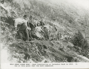
Photograph, Great Ocean Road. Road construction at Cathedral Rock. 1919
Group of workmen. Cathedral Rock where the work commencedstart of construction, great ocrean road. cathedral rock -
 Lorne Historical Society
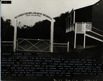
Photograph, Great Ocean Road. Tollgate and house
The toll gate and house was erected at Stradbroke Knoll, Grassy Creek by JC Taylor and sons of Geelong . Construction was completed on Christmas Day 1922. It was moved from Grassy Creek to Cathedral Rock in October 1929 where it stayed until 1936. It was then sold and moved to Lorne. It is the second house on the right in Minapre Street. The Gatehouse keepers at the time were Mr and Mrs Wright. The original Gatekeepers were Mr and Mrs MacKay. They left Grassy Creek with their family on 11 May 1926The GOR Tollgate and house were originally erected by J.C. Taylor and Sons of Geelong, at Stradbroke Knoll, Grassy Creek and construction was completed on Christmas Day 1922. It was moved from Grassy Creek to the Springs at Cathedral Rock in October 1929 where it stayed until 1936, It was then sold and moved to Lorne. It is the second house on the right in Minapre Street. The gatehouse keepers at this time were Mr. & Mrs.Wright. The original gatekeepers were Mr & Mrs Mackay. They left Grassy Creek with their family on 11th May 1926j.c. taylor and sons. gor, tollgate. -
 Lorne Historical Society
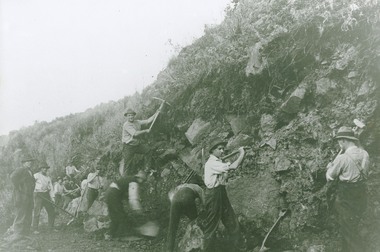
Photograph, Great Ocean Road Construction workers using picks and shovels
Photo G.O.R. Construction Workers using picks and shovelsgreat ocean road; road contruction, handtools, workers -
 Lorne Historical Society
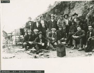
Photograph, Smoko at Big Hill 1920
Group of Great Ocean Road construction workers., with machinery and Billy teagreat ocean road, big hill, road construction -
 Lorne Historical Society
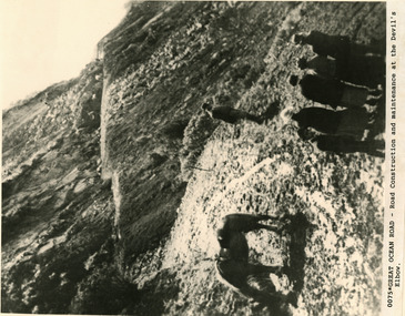
Photograph, Great Ocean Road Construction and maintenance at Devils' Elbow
Group of workers with a horseGroup of working men and horse at Devil's Elbowgreat ocean road construction, devil's elbow, workmen and horse -
 Lorne Historical Society
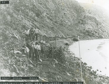
Photograph, G.O.R, Construction work at Cathedral Rock 1920
Photograph showing group of workmen and equipment at Cathedral Rock during construction G.O.R 1920g.o.r. workmen, construction, equipment. group photograph -
 Lorne Historical Society
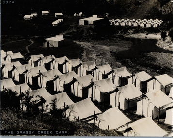
Photograph, The Grassy Creek Camp
Close up photograph of tents and site camp at Grassy Creek G.O.Rg.o.r. country roads board camp site - construction grassy creek -
 Lorne Historical Society
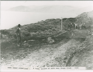
Photograph, Team of Horses and workmen at Moggs Creek. G.O.R. construction 1920
G.O,R. construction at Moggs Creek. Team of workmen and horsesmoggs creek 1920 ; horse teams and workmen, g.o.r -
 Lorne Historical Society
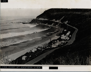
Photograph, C.R.B. Camp at Eastern View
Photograph showing and overview of Country Roads Board Camp at Eastern Viewg.o.r.: c, r.b. construction camp at eastern view -
 Lorne Historical Society
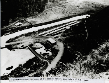
Photograph, St. George River C.R.B. Camp
Photo of the C.R.B. Construction Camp at St George Riverg.o.r.: c.r.b. camp site: st george river. -
 Lorne Historical Society
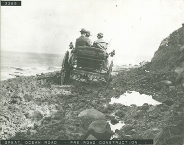
Photograph, Great Ocean Road, pre road construction
Photograph pre construction of the Great Ocean Road showing three adults and horse drawn carriage. pre-road-construction. horse-drawn-carriage. g.o.r -
 Lorne Historical Society
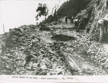
Photograph - Men working on Great Ocean Road Lorne - photograph
Photograph showing workmen during coonstruction of Great Ocean Road near Lorne.great ocean road construction; workmen -
 Lorne Historical Society
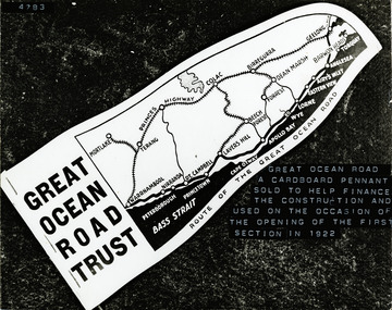
Photograph, Cardboard Souvenir Pendant sold to finance G.O.R constuction
Photograph of a cardboard pendant sold by the G.O.R. Trust to help finance the construction of the road. and used on the occasion of the opening of the first section in 1922great ocean road trust; financing of great ocean road; cardboard pendant -
 Lorne Historical Society
Photograph, Grassy Creek C.R.B. Camp
Photo of the Grassy Creek C.R.B site looking towards Aireys Inlet. Top left hand corner - the first tents were the gangers next were the mine and the third the timekeepers. The camp site is in the valleyg.o.r.; c.r.b. construction camp sites; gangers; mine; timekeeper; grassy creek; -
 Lorne Historical Society
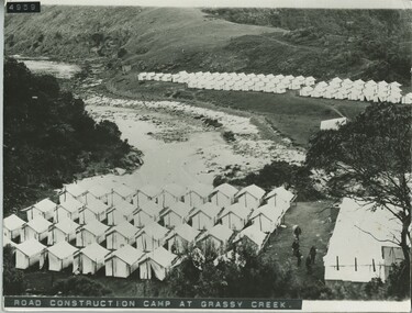
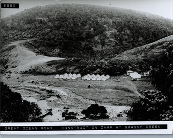
Photograph, Road Construction Camp Grassy Creek
Overview photograph of tents and campsites at Grassy Creekg.o.r; construction camp site; tents; c.r.b.; grassy creek; -
 Lorne Historical Society
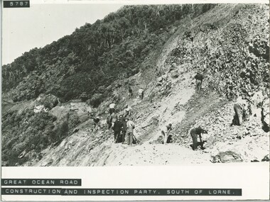
Photograph, Great Ocean Road construction inspection party
Photo of construction inspection party at south Lorne -
 Lorne Historical Society
Photograph, G.O.R Construction Cumberland circa 1920
Workmen with tractor, cement mixer G.O.R Cumberland Riverg.o.r.; cumberland, ; workmen-tractor-cement-mixer; -
 Lorne Historical Society
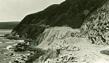
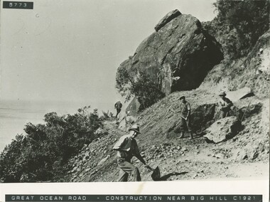
Photograph, G.O.R Construction near Big Hill circa 1921
Photograph showing G.O.R. construction workers near Big Hill. Circa 1921g.o.r.; big-hill; circa-1921; workmen; -
 Lorne Historical Society
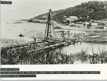
Photograph, Building of the bridge at Wye River, on G.O.R
Photograph showing construction of the bridge at Wye River on the G.O.R.g.o.r; wye-river; g.o.r; bridge-construction; -
 Lorne Historical Society
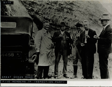
Photograph, Five members of Great Ocean Road inspection team
Group Photograph showing inspection party with vehicle on G.O.R. construction site -
 Lorne Historical Society
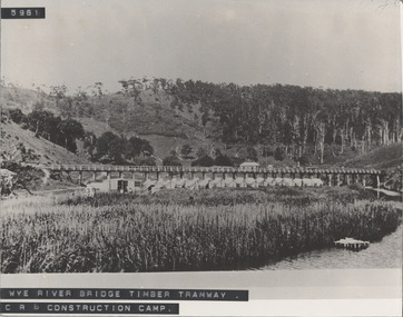
Photograph - Black and white photograph, Wye River Bridge Timber Tramway
Photograph showing the Wye River Bridge Timber Tram way at the C.R.B Construction Campwye-river-bridge, timber-tramway, c.r.b.-construction-camp, wye river bridge, timber tramway, c.r.b. construction camp, country roads board -
 Lorne Historical Society
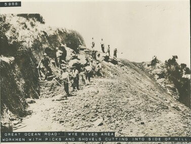
Photograph, Workmen with hand tools Great Ocean Road near Wye River
Photograph of G,O,R. construction area at Wye River, showing construction worker cutting into the side of the hill with picks.g.o.r.; wye-river; construction-workers; -
 Lorne Historical Society
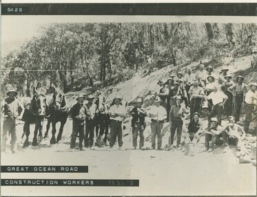
Photograph, Great Ocean Road construction workers 1930's
A Group photograph of construction workers - circa 1930's g.o.r; construction-work-circa-1930's; -
 Lorne Historical Society
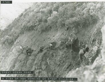
Photograph, Men working on steep hillside Great Ocean Road
Photograph of men working on the steep hill site during the construction of the G.O.R.g.o.r. workmen -
 Lorne Historical Society
Photograph, Memorial wall at Mt, Defiance
Photograph showing the construction of the Memorial Wall at Mount Defiance.g.o.r; memorial-wall; mt.-defiance; -
 Lorne Historical Society
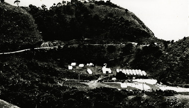
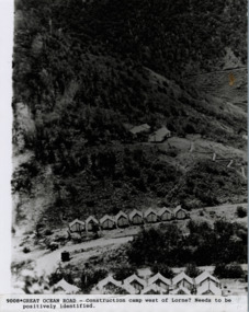
Photograph - Construction camp Great Ocean Road , near Lorne, Great Ocean Road construction camp near Lorne
Over view of a construction camp thought to be West of Lorne.g.o.r.; c, r, b.-construction camp; -
 Lorne Historical Society
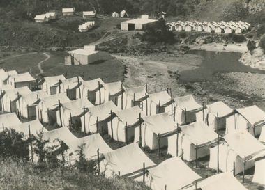
Photograph, Workers tents at Grassy Creek camp Great Ocean road
Photograph showing rows of tens and utility tents at the construction camp at Grassy Creek on the Great Ocean Road -
 Lorne Historical Society
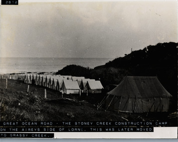
Photograph, Stony Creek Construction Campsite Great Ocean Road
Photograph showing overview of Stony Creek construction campsite on the Airey's Inlet side of Lorne. This site later moved to Grassy Creek.g.o.r; construction camp site; tents; c.r.b.; grassy creek; -
 Lorne Historical Society
Photograph - Photo, Grassy Creek Camp
Close up photograph of tents and site camp at Grassy Creekgrassy creek, crb camp site, construction camp site