Showing 1104 items
matching lake road
-
 Glenelg Shire Council Cultural Collection
Postcard - Postcard - Glenelg River Nelson, Victoria, n.d
Postcard, full colour, sunset at Glenelg River Estuary at Nelson, Victoria.Front: 'Glenelg River Estuary, Nelson - Victoria Australia' - blue print. -
Glenelg Shire Council Cultural Collection
Booklet, A. Massola, Curator of Anthropology National Museum of Victoria, Melbourne, A History of Lake Condah Aboriginal Reserve, 1963
Booklet, light grey card covers with burgundy print. 20 pages, black print, black and white photos of Lake Condah Mission. -
Glenelg Shire Council Cultural Collection
Map - Map - Bridgewater Lakes Tour, 1970s
Typed up directions around the Bridgewater area. Inside: Map of Portland - Bridgewater area.map, tourism, travel, recreation, cape bridgewater -
Glenelg Shire Council Cultural Collection
Photograph - Photograph - Cape Bridgewater Lakes, Victoria, c. 2000
... Cliff Street Portland great-ocean-road Coloured photograph ...Coloured photograph: Bridgewater Lakes, Discovery Bay from top of the hill -
Glenelg Shire Council Cultural Collection
Photograph - Photograph - aerial view of Portland coast, c. 1954
Black and white aerial photograph of coastline around Portland. Black border, scale all sides, 5 rows of 3 't' at regular intervals. Ocean, land with lakesFront: '820 -8' - handwritten, white, lower border 'RUN 5' 'PORTLAND', printed, white, lower borderaerial photography, central portland, portland harbour, south west coastline -
Glenelg Shire Council Cultural Collection
Decorative object - Trinket Box with Lid, n.d
Small silver metal trinket box, filigree around sides. Lid has inlaid black and white photograph of an old building beside lake or river. Filigree border around photocontainer, filigree, silver plate -
Glenelg Shire Council Cultural Collection
Pamphlet - Pamphlets - Portland and surrounds, Victoria, n.d
Collection of pamphlets, information and maps for seven tourist tours of Portland and district. a. green Tour No. 1 Town of Portland b. pale yellow Tour No.2 Portland Harbour c. blue Tour No. 3 Scenic Drive d. gold Tour No. 4 Cobboboonee Forest e. yellow Tour No.5 Nelson, Glenelg River and caves f. pink Tour No. 6 Bridgewater Bay, Lakes, Blowholes g. orange Tour No. 7 Yambuk Lakes, Mt. ClayFront: 'VIVIAN' -handwritten, blue biro, top right -
Glenelg Shire Council Cultural Collection
Photograph - Photograph - aerial view of Portland, c. 1954
Black and white aerial photograph of coastline around Portland. Black border, scale all sides, 5 rows of 3 't' at regular intervals. Small area of ocean, rest land with lakes.Front: '820 -9' - handwritten, white, border 'RUN 5' 'PORTLAND', printed, white, lower borderaerial photography, central portland, portland harbour, coastline -
Glenelg Shire Council Cultural Collection
Memorabilia - Calendar - Victour 1962, DESIGNER - AGFM PRODUCTIONS P/L, c. 1962
Victour Calendar 1962, includes coloured image of Loch Ard Gorge and Bridgewater Lakes. Green, cream and gold cover, spiral bound, support on back for standing it up. -
Glenelg Shire Council Cultural Collection
Photograph - Photograph - rural scene, Cape Bridgewater, n.d
Coloured photograph of wind-blown trees and undulating landscape above Bridgewater Lakes (possibly)landscape photography, cape bridgewater, lakes, scenic -
Glenelg Shire Council Cultural Collection
Photograph - Photograph - Portland Library, Victoria, 01/06/1998
Coloured photo. Portland Library. National Reconciliation Week display, featuring Lake Condah Mission.Front: '98 6 1 ' -
Glenelg Shire Council Cultural Collection
Photograph - Photograph - Swan Lake Camp Ground, 1939, 1939
The Portland Surf Life Saving Club was established in 1935.Black and white photo of Swan Lake, mounted on grey matt board. Parts of a poster glued above and below photo promoting Portland Surf Life Saving Club annual picnic, Sat 21 January, 1939.Back: 'Thelma Campbell' - hand written, blue biroportland surf life saving club, pslsc, swan lake, camping, picnic, recreation -
Glenelg Shire Council Cultural Collection
Postcard - Postcard - Princess Margaret Rose Cave, n.d
Full colour photo/postcard of the interior of one of the Princess Margaret Rose Caves, showing stalagmites and stalactites; white border, with black print 'PRINCESS MARGARET ROSE CAVE, SOUTH WEST VICTORIA, AUSTRALIA'.postcard, tourism -
Glenelg Shire Council Cultural Collection
Postcard - Postcard - Princess Margaret Rose Caves, n.d
Coloured photo/postcard of interior of Princess Margaret Rose Cave, showing formation known as 'The Long Engagement and the Wedding Cake'.tourism, princess margaret rose caves, postcard -
Glenelg Shire Council Cultural Collection
Postcard - Postcard - Bridgewater Lakes, n.d
... Cliff Street Portland great-ocean-road Back: 'Bridgewater Lakes ...Coloured photo postcard, Bridgewater Lakes, taken from the hill above the lakes, looking directly across them to the sea.Back: 'Bridgewater Lakes near Portland, Vic' printed in blue, bottom left 'Rose series, Colorview No. 585' printed in blue, down right hand side -
Glenelg Shire Council Cultural Collection
Souvenir - Sticker - Princess Margaret Rose Caves, n.d
Oval coloured sticker, photo of stalactites in Princess Margaret Rose Cave. White print: 'Princess Margaret Rose Cave' round top edge. 'Lower Glenelg National Park' around lower edge. Sticker attached to white backing paper.tourism, princess margaret rose caves -
Glenelg Shire Council Cultural Collection
Souvenir - First Day Cover - Cape Northumberland Lighthouse 150th Anniversary, Jan-09
Benjamin Germein was the lighthouse keeper at Cape Northumberland at the time of the wreck of the AdmellaEnvelope, 1st Day Cover, Cape Northumberland Lighthouse 150th Anniversary, 2009. Marble parchment envelope, photo Captain Benjamin Germein, first lighthouse keeper, above depiction of lightstation; 50 cent stamp cancelled 1 January 2009 at Port MacDonnell, SA. Bottom right, photo of designer and John Jordan, last keeper of light.first day cover, admella, stamp, souvenir -
Glenelg Shire Council Cultural Collection
Souvenir - Tea Towel, Designed in Australia by JONEFF, n.d
Linen souvenir tea towel, 'PORTLAND, VICTORIA, AUSTRALIA' printed in blue and red on white clouds. Depiction of Portland plus harbour, looking east, Portland's coat-of-arms beneath, with red banner, 'Henty Bros. settled 1834'. Beneath this, 4 views of Portland: Bridgewater Lakes, Henty Beach, Grain Terminal, Aerieal view of Portland. Blue background. Red border. -
Glenelg Shire Council Cultural Collection
Flyer, Condah Progress Association Grand Carnival, c. 1969
... Cliff Street Portland great-ocean-road Lake Condah Condah ...Flyer, green, A3, black print, advertising Condah progress Associations, Grand Carnival.lake condah, condah, advertising -
Glenelg Shire Council Cultural Collection
Photograph - Reproduction Photograph - Bridgewater Lakes, 1920s
... Cliff Street Portland great-ocean-road Front: 'BRIDGEWATER LAKES ...Black and white photograph (reproduction). Groups of men and ladies at Bridgewater Lakes, one group walking over a bridge made of sticks, one group either side of bridge, two ladies sitting on hillside above the bridgeFront: 'BRIDGEWATER LAKES' - bottom right Back: '848' in pencil -
Glenelg Shire Council Cultural Collection
Souvenir - Wooden Shield, n.d
Portland Highland Pipe BandWooden shield with 8 shield shaped silver plaques and one oval plaque, arranged around a central larger oval plaque. This larger plaque is decorated on the outside with a silver wreath hang top of shield is a silver banner. Inscriptions a banner,and all plaques. Two hooks with string to hang, on back.Front: Banner - 'Portland annual street march Highland gathering' Central Plaque: J.G Murrell Memorial Shield 1959 Other plaques: 1959 - Portland Highland Pipeband 1962 - Portland Ladies H.P.B 1966 - Naracoorte H.P.B 1960 - Horsham Pipeband 1963 - Blue Lake Ladies 1967 - Warrnabool and District 1961 - Naracoorte Highland Pipeband 1964 - Portland H.P.B 1968 - Portland H.P.Bportland highland band, memorial shield, 1959, music -
Glenelg Shire Council Cultural Collection
Pamphlet - Brochure - Lake Condah History Walk, Mar-88
'Bower Bird' Museum, HeywoodPale yellow with brown print brochure. A3 size, folded in half, men tri-fold, Lake Condah History walk. -
 Halls Gap & Grampians Historical Society
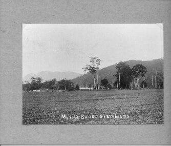
Photograph - B/W, C 1912- 1914
Residence of Warren family overlooked by Upper Halls Gap range Site now under Lake BellfieldBuildings of Myrtlebank overlooking paddock Back drop Upper Halls GapPhoto mounted on cardboardbuildings, houses, myrtlebank -
 Halls Gap & Grampians Historical Society
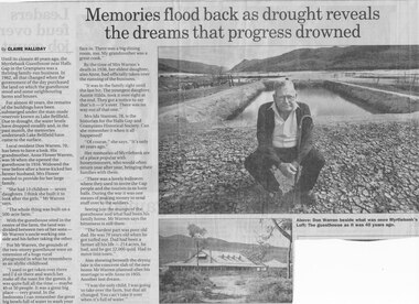
Newspaper - B/W
Until the closure 40 years ago, the Myrtlebank Guesthouse near Halls Gap in the Grampians was a thriving family - run business. In 1962, all that changed when the government of the day purchased the land on which the guesthouse stood and some neighbouring farms and houses. For almost 40 Years, the remains of the buildings have been submered under the man made reservoir known as Lake Bellfield. Due to drought, the eater levels have dropped steadily and, in the past month, the memories underneath Lake Bellfield have come to the surface. Local resident Don warren 70, has been to have a look. His grandmother Anne Flower Warren, was 56 when she opened the guesthouse in 1916. Widowed, the year before after a horse kicked her farmer husband, Mrs Flower needed to provide for their large family. "She had 13 children - seven daughters. I think she built it to look after the girls," Mr Warren says, "The whole think was built on a 500 acre farm." With the guesthouse sited in the centre of the farm, the land was divided between two of her sons- Mr Warren's uncle working one side and his father taking the other. For Mr Warren, the grounds of the two-storey guesthouse were an extension of a huge rural playground in what he remembers as an idyllic childhood. "I used to get taken over there and I'd sit there and watch her make all the toast for the guests. It was quite full all the time - maybe 40 or 50 people. It was a great big place - very grand. In the bedrooms I can remember the great big bowls full of water to wash your face in. There was a big dining room, too. My grandmother was a great cook." By the time of Mrs Warren's death in 1936, her eldest daughter also Anne, had officially taken over the running of the business. "It was in the family right until the last bit. The youngest daughter, Auntie Hilda, took it over right at the end. they got a notice to say that's it - it's over There was no way out of that one." Mrs Ida Stanton, 78, is the historian for the Halls Gap and Grampians Historical Society. Can she remember it when it all happened? "Of course" she says "It's only 40 years ago" Her memories of Myrtlebank are of a place popular with honeymooners, who would often return year after year, bringing their families with them. "There was a lovely ballroom where they used to invite the Gap people and the tourists in to have balls. During the war it was one means of making money to send stuff over to the soldiers." Seeing just the stumps of the guesthouse and what had been his family home, Mr Warren says the bitterness is still there. "The hardest part was poor old dad. He was 70 years old when he got turfed out. Dad had been a farmer all his life - 214 acres, he had, and he got 22,000 quid. Had to move into town" Also showing beneath the drying lake is the concrete slab of the new home Mr Warren planned after his marriage to wife Anne in 1955. Another lost dream. " I was the only child, I was going to take over the farm, but that all changed. You can't take it over when it's full of water.Newspaper clipping of history of Myrtlebank by Don Warren and photo of Don at old site of pooland guest House photo Article by Claire Halliday from newspaper 2002accommodation, guesthouses, myrtlebank -
 Halls Gap & Grampians Historical Society
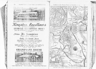
Magazine - Photocopy
Kingston Roadliners (F. Kingston, Proprietor) STAWELL - GRAMPIANS DAILY Coach for the Grampians meets mid day train at Stawell Return Daily Make the Grampians your next vacation Daily Conducted Tours, from Hotels and Guesthouses in Stawell and Hall's Gap to WONDERLAND - MCKENZIE FALLS - LAKE WARTOOK - MT. VICTORY - MT ROSEA - WANNON VALLEY conducted Hiking Trips Arranged Stawell booking office: 75 Main Street - Phone: Stawell 214, Hall's Gap booking office: Main Road - Phone: Hall's Gap 35, Bookings also from Vitorian Government Tourist Bureau, Cars for hire GRAMPIANS HOUSE The Most Conveniently Situated Tourist House in the Grampians. Ballroom, electric light, large garage, hot water service, hot water in all rooms, internal sewerage. Tennis, fishing, shooting, Alongside is the Bowling Green, where visitors are welcome to play. Phone: Hall's Gap 28. Tariff on application. Manageress: Mrs, E. MatthewsAdvertisement for Kingston Roadliners, Grampians House and Map of the GrampiansAdvertisement in Broadbents, Guide of western Victoria, and South-East of S.A.media, advertisements, grampian house -
 Halls Gap & Grampians Historical Society
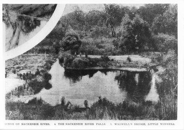
Photograph - B/W
This is the pondage below Wartook Lake embankment. The photo is from the Weekly Times. Oddly, the inscription on the bottom of the photo does not appear to relate to the images.Photo shows a river with four people standing on a sandy bank. Four other people can be seen in the forgrouns standing on the near bank. A smaller inset at the top left corner seems to show a tee reflected in water.scenery, mackenzie river -
Halls Gap & Grampians Historical Society
Photograph - Sepia, C 1920s (?)
Men on the upstream embankment of Lake Wartook.Photo shows five men (one only partly visible n the left side) on the rocky embankment of a large body of water (Lake Wartook).scenery, lake wartook -
Halls Gap & Grampians Historical Society
Photograph - B/W, C 1920s
The house in the photo is the caretaker's residence at Lake Wartook. The men and dogs are standing next to the intake tower.The photo shows a small weatherboard house, with a group of eight men and three dogs standing beside it, on the side of a large lake (Lake Wartook). The house is on a platform, built up with stones and there is a stone pillar with platform leading to it in the lake to the right of the men. There is bush with hills rising above them in the background.scenery, lake wartook -
 Halls Gap & Grampians Historical Society
Photograph - Coloured, C 2007
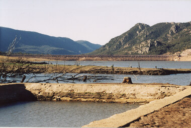
This is a photo of the exposed swimming pool of Myrtlebank, which became exposed in Lake Bellfield during the drought years (2007 - ). The view is looking towards the dam wall.Photo shows an exposed swimming pool (Myrtlebank Pool) in a very low reservoir (Lake Bellfield). There are dead branches in the water behind the pool and the dam wall can be seen in the background.recreation, swimming pool -
 Halls Gap & Grampians Historical Society
Photograph - Coloured, C 2007
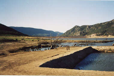
This is a photo of the exposed swimming pool of Myrtlebank, which became exposed in Lake Bellfield during the drought years (2007 - ). The view is looking towards the dam wall and further road through the valley..Photo shows an exposed swimming pool (Myrtlebank Pool) in a very low reservoir (Lake Bellfield). There are dead branches in the water behind the pool and the dam wall and former road through the valley can be seen in the background.recreation, swimming pool