Showing 10914 items
matching lander
-
 Wycheproof & District Historical Society Inc.
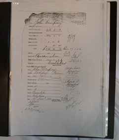
Dempsey Book, Dempsey Land Selection, 2003l
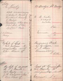
Mr Dempsey and family were the first selectors to arrive at Mt Wycheproof 1872 or early 1873. One Dempsey Land Application is dated 15-3-1873.Factual documents obtained from a Melbourne archive show settler,John Dempsey,securing land at Wycheproof. Several official Lands Department correspondence provides evidence of Dempsey's early land acquisition at the beginning of the town's farming history and settlement from 1872 - 1882. This is an A3 sized Display book with grey spine. Comprises official Lands Department Papers detailing Mr John Dempsey's Land Applications and acquisition at Wycheproof. Dated documentation is from 1872 through to 1882.Locally researched references give an overview about the Dempsey family.dempsey, land -act, bunguluke -
 Hume City Civic Collection
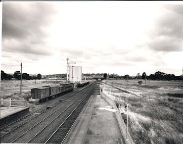
Photograph, 1/01/1971
The photograph was taken when railway land on either side of the tracks was used for recreational purposes and agricultural related activities. The local sports ground is on the RHS of the photograph and was used to stage a number of the town's events.A black and white photograph of a section of the two railway platforms and three sets of rail tracks with a stone bridge in the distance. Four rail carriages and eight goods trucks are on a railway siding near a wheat silo. There is open land on either side of the rail tracks.sunbury railway station, wheat silos, railways, macedon street rail bridge., george evans collection -
 Phillip Island and District Historical Society Inc.
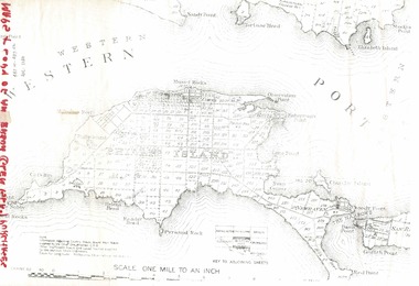
Document, 1869 Crown Land sale and map of Phillip Island showing allotments
Anderson and McHaffie were prominent early settlers of Phillip Island. These documents were from the estate of Stan Mcfee snr. Listings of auctions at Gemmell, Tuckett & Co., Collins Street, Melbourne 12 February, 1869HistoricalCopy of map showing allotments for 1869 land sale and hand written note showing allotments, area, prices for purchases of Robert Anderson and notes on McHaffie land.robert anderson, glen isla, john mchaffie, maps, land sales -
 Whitehorse Historical Society Inc.
Legal record - Land Title, Forest Hill
Handwritten list of transfers of land in Forest Hill originally bought by H.R. Kefford in 1867.Handwritten list of transfers of land in Forest Hill originally bought by H.R. Kefford in 1867. Includes land of Nunawading High School and Forest Hill Shopping Centre.Handwritten list of transfers of land in Forest Hill originally bought by H.R. Kefford in 1867. springvale road, forest hill, canterbury road, kefford, h r, wakefield, john, hartnett, rhoda, reed, william, freehold investment and banking company of australia ltd., lane, john owen, mcarthur, henwood, draeger, carl julius otto, arthur herbert, loomes, vincent, biggs, benjamin, broadhurst, harry tootal, foster, henry, hinricks, henry jesse, barnes, john thomas, mary ann, jay, daniel, cuttle, thomas nathaniel, mock, walter edward, glebe street, forest hill chase, nunawading high school, land sales -
 Bendigo Historical Society Inc.
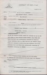
Document - H. A. & S. R. WILKINSON COLLECTION: CONTRACT OF SALE
Contract of sale of land dated 4th April, 1955 between Mrs. M. Phillips (vendor) and Mr. R. J. Pentland (purchaser). Solicitor for vendor and purchaser: Hyett, Willis & Hyett. Property: Land situate in Albert Street, Long Gully described in right to occupy residence area No. 5469 also all vendor’s right. title and interest in land adjoining the above land being land described in permissive occupancy No. W63435, together with weatherboard dwelling and all sundry. Price: 1,600 pounds.organization, business, h.a. & s.r wilkinson real estate -
 Surrey Hills Historical Society Collection
Book, Surrey Hills: in celebration of the centennial 1883-1983, Reprinted November 1992
A pictorial history of Surrey Hills and Mont Albert based on information collected by the history group at the Surrey Hills Neighbourhood Centre. It includes information about early rural properties and dairies, the coming of the railway, land sub-division and early homes, doctors, schools, churches, parks and recreation facilities.A pictorial history of Surrey Hills based on information collected and based at the Surrey Hills Neighbourhood Centre. It includes early rural properties and diaries, the coming of the railway, land sub-division and early homes, schools, parks and recreation.1992surrey hills, railways, land use, migrants, spanish communities, transport, houses, wattle park, festivals and celebrations, churches, education, water supply, fire stations, hospitals, (mr) george klepper, ainger family, (mr) john woodhead, (mr) h. breedon, medical services, real estate agents, businesses, musical events and activities, entertainment, parks and reserves, scouts, guides -
 Ringwood and District Historical Society
Envelope, Packet: Anthony Ford Application for land Ringwood 1870
Copies of application for land by Anthony Ford, Ringwood 1870 -
 Bendigo Historical Society Inc.
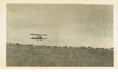
Postcard - BASIL WATSON COLLECTION: BIPLANE FLYING OVER LAND
postcard: biplane flying over land, no location given.aviation, civilian, biplane, basil watson collection, biplane -
 Bendigo Historical Society Inc.
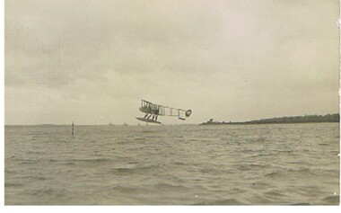
Postcard - BASIL WATSON COLLECTION: BIPLANE ON WATER
postcard: biplane about to land on water, no location givenA. Rapp. Marine Photographer, 39 Bernard Street, Southhamptonaviation, civilian, biplane, basil watson collection, a. rapp -
Clunes Museum
Plan - TITLE PLAN CAMPBELLTOWN, PARISH OF CAMPBELLTOWN, 1876
1 PAGE PHOTCOPY OF LAND TITLE PLANS 18752658 C 364 PARISH OF CAMPBELLTOWN COUNT OF TALBOT COMPILED BY CHARLES MCDONALS 1876campbelltown titles plan, photo-lithographic -
University of Melbourne, Burnley Campus Archives
Document, Land & Food, 2004
Newsletter of the Institute of Land & Food Resources - The University of Melbourneinstitute of land and food, university of melbourne -
University of Melbourne, Burnley Campus Archives
Document, Burnley Gardens, 1976
Memo re changes in areas of land granted to Burnleyburnley gardens, land -
 Whitehorse Historical Society Inc.
Photograph, Land in Livingstone Road, South Vermont
Coloured photo of Land in Livingstone Road, South Vermont.to be entered -
 Whitehorse Historical Society Inc.
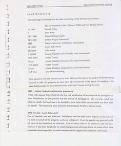
Document - Article, Land Ownership
Schwerkolt Cottage Land Ownership from 1858 to 1964.land titles, riley patrick, schwerkolt johann audust, schwerkolt louis, kruse john, jackschowsky mary, schwerkolt cottage, public trustee -
 Ballarat Heritage Services
Photograph, Clare Gervasoni, Entrance to Merino Downs Henty, 2015, 22/12/2015
Merino Downs was the property of early squatters the Henty brothers. Pentonvillian Axile George Ind worked for the Henty's at Merino Downs after his arrival at Portland in 1845. The Henty Girls were witnesses to his marriage. Colour photograph of land around Merino Downs, Hentyhenty, merino downs, henty brothers, george ind -
 Bendigo Historical Society Inc.
Book - GALLAGHER COLLECTION: REAL ESTATE SALES W. MCKEAN & CO, 1930
Book. Land sales. April 1930 to July 1937. -
Hand Tool Preservation Association of Australia Inc
Pamphlet
This item is part of the Thomas Caine Tool Collection, owned by The National Trust of Australia (Victoria) and curated by the Hand Tools Preservation Association of Australia.4 page promoting ascot vale land sale -
University of Melbourne, Burnley Campus Archives
Document, The University of Melbourne, With Compliments, 1997-2007
stationery, land & food resources, staff -
University of Melbourne, Burnley Campus Archives
Document - Prospectus, School of Land and Environment, Graduate Prospectus, 2011
courses, graduates -
 Ringwood and District Historical Society
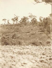
Photograph, Clearing at "Quambee", North Ringwood - 1912
Sepia photograph showing land after partial clearing. -
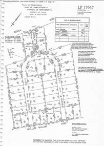 Ringwood and District Historical Society
Document - Subdivision Plan, LP17967 Part of Crown Allotment 33, Parish of Warrandyte, County of Evelyn, Vol 6141 Fol 054 - 1948
LANDATA Land Victoria plan printout dated 2008Map includes Wonga Road, Berea Avenue, Fyfe Avenue and Collett Avenue, Ringwood. Markings also include PS309215, LP143952, LP210020, LP24182, LP70960, SP29097, RP9235, SP19956 and LP113437. -
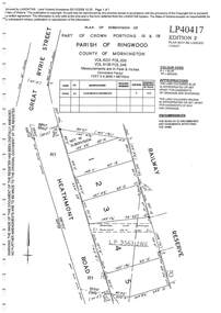 Ringwood and District Historical Society
Document - Subdivision Plan, LP40417 Part of Crown Portions 16 & 18, Parish of Ringwood, County of Mornington, Vol 6231 Fol 035 and Vol 8139 Fol 248 - 1957
LANDATA Land Victoria plan printout dated 2008Map includes Heathmont Road, Heathmont, with allotments adjoining Railway Reserve. Other markings include LP95632NS. -
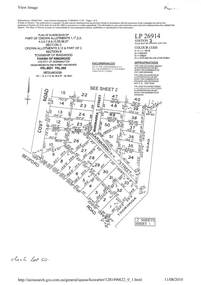 Ringwood and District Historical Society
Document - Subdivision Plan, LP26914 Multiple Crown Allotments, Parish of Ringwood, County of Mornington, Vol 8021 Fol 053 - 1954
LANDATA Land Victoria plan printout dated 2010Part of Crown Allotments 1, 1A, 2, 3, 4, 5, 6, 7, 8, 9, 10, 55, 56, 57. Section C Crown Allotments 3, 12 & part of 2. Section B Map includes Bedford Road, Government Road (later Bedford Park Road then Hill Street), Marwarra Street and Tooronga Road, Ringwood. (Sheet 1 of 2 - Sheet 2 not included with collection). -
 Ringwood and District Historical Society
Document - Subdivision Plan, LP10477 Parish of Warrandyte, County of Evelyn, Vol 2453 Fol 574 - 1924
LANDATA Land Victoria plan printout circa 2010Part of Crown Allotment 30. Map includes Warrandyte Road, Kennedy Avenue and Wonga Road, Ringwood. Street name amended from Wonga Road to Loughnan Road 1940. Other markings include CP102182, CP171386, LP127934, PS349846, RP7582, PS309312,RP8679 and CP106336. -
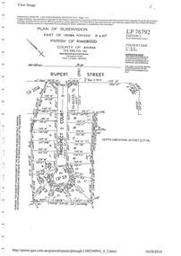 Ringwood and District Historical Society
Document - Subdivision Plan, LP76792 Part of Crown Portions 19 & 20A, Parish of Ringwood, County of Bourke, Vol 8382 Fol 140 - 1967
LANDATA Land Victoria plan printout dated 2010Map includes Rupert Street and Prospect Court, Ringwood. -
 Ringwood and District Historical Society
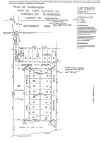
Document - Subdivision Plan, LP23855 Part of Crown Allotment 14B, Parish of Ringwood, County of Mornington, Vol 6687 Fol 394 - 1952
LANDATA Land Victoria plan printout circa 2008Map includes Cuthbert Street, Orchard Grove, and Lowen Avenue (formerly part of Balfour Avenue), Heathmont. Other markings include SP25736, LP98835 and LP40209.