Showing 1290 items
matching lands
-
 Bendigo Historical Society Inc.
Map - PARISH OF EGERTON, 19/03/1894
Map: Parish of Egerton, Settlement on Lands Act 1893, County of Bendigo. Parish plan ( number 245 in Map Cupboard 1)map, bendigo, settlement on lands act 1893, egerton, settlement on lands act 1893. -
 Whitehorse Historical Society Inc.
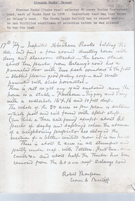
Report, Abraham Rooks holding, ca 1870
Inspection of Abraham Rook's holding of 80 acres including description of house, outhouse, fencing, waterhole, stable by the Crown Lands Bailiffthompson, robert, rooks, abraham, land settlement -
 Bendigo Historical Society Inc.
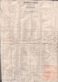
Map - MAP. WARRAGAMBA. COUNTY OF BENDIGO, 1915
Map. Warragamba. Colunty of Bendigo. Pannoomilloo. Minto. Diggorra. Kamarooka Photographedat the Department of LANDS AND Survey Melbourne by W. J. Butson. -
 Bendigo Historical Society Inc.
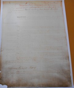
Document - 1856 PETITION COPY
Copy of petition from Sandhurst Crown Lands occupants to Major General Macarthur, Acting Governor of the colony of Victoria, seeking consideration for the improvements they had made on the lands they occupied under business licenses. Eighteen pages containing signatures, addresses and occupation of 1,387 storekeepers, publicans, miners, professionals and persons in various types of employment.bendigo, history, 1856 crown land occupants petition -
Bendigo Historical Society Inc.
Map - COUNTRY LANDS, 4/06/1874
Map: Country lands, Parishes of Goornong, Egerton, Elmore and Nolan, County of Bendigo. Parish plan (number 298 in map cupboard 1)map, bendigo, country lands, country lands, goornong, elmore, egerton, nolan -
Canterbury History Group
Document - Railway Communication with Doncaster, Kew and the Kew Asylum and Yarra Bend Asylum Lands, J.Kemp Government Printer, 1908
Report from the Parliamentary Standing Committee on Railways, on the question of Railway Communication with Doncaster, Kew, and the Kew Asylum and Yarra Bend Asylum Lands.canterbury, doncaster, kew, yarra bend asylum, kew asylum, victorian railways, outer circle railway, railways standing committee, victorian government -
University of Melbourne, Burnley Campus Archives
Plan (Item), Plan of Burnley Gardens, City of Richmond, Parish of Jika Jika, County of Bourke, 1948
(On original) : Notes by W(?) Anderson 28/2/45. Date stamp of School of Primary Horticulture and Agriculture Burnley E1burnley gardens, richmond, department of lands & survey, orchard -
Lakes Entrance Historical Society
Book, LERHS, Alfred William Howitt, 2018c
Compiled information on Alfred William Howitt Crown Lands Commissioner, Police Magistrate, Warden of the goldfields and coroner for the district of Omeo Victoria Victoriamines and mining, exploration, law -
 Bendigo Historical Society Inc.
Map - JACK FLYNN COLLECTION: TARNAGULLA SHEET 4, 25/11/1926
Map: Parish of Tarnagulla Sheet 4, Counties of Gladstone and Bendigo. Parish plan.Photo-Lithographed at the Department of lands and Survey, Melbourne by W. J. Butson. 25.11.26map, gladstone, parish plan, tarnagulla sheet 4 -
 Bendigo Historical Society Inc.
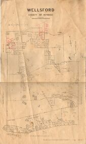
Map - JACK FLYNN COLLECTION: WELLSFORD, 2/11/1914
Map: Parish of Wellsford, County of Bendigo. Parish plan.Photo-Lithographed at the Department of Lands and Survey Melbourne By H.J. Butson. 2-.11.14map, bendigo, parish plan, wellsford -
 Bendigo Historical Society Inc.
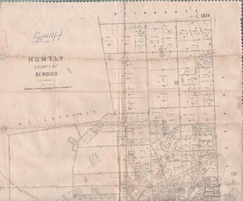
Map - JACK FLYNN COLLECTION: HUNTLY, 12.03.1932
Map: Township of Huntly, Parish of Huntly , County of Bendigo. Parish plan. Western and South Riding Division on Main St. (Main Northern Highway) - written in ink below name of map.BY Authority H.J. Green. Photo-Lithographed at the Dept., of Lands and Survey, Melbourne. 12.3.32map, bendigo, township, huntly -
 Bacchus Marsh & District Historical Society
Map, Mooradoranook Parish Map, County of Grant
A single page paper map showing the map for the Parish of Mooradanook in the County of Grant. Cadastral map showing land ownership. The map is pasted into a bound volume containing 76 maps or plans in total. High resolution digital image stored on BMDHS computer network. Photo lithographed at the Department of Lands and Survey Melbourne by T. F. McGauran, 27.11.06mooradoranook parish maps, mooradoranook parish plan, bacchus marsh region parish plans -
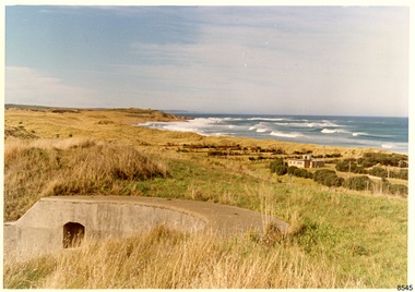 Flagstaff Hill Maritime Museum and Village
Photograph - Historical, Flagstaff Hill, Warrnambool Garrison Fortifications looking towards the Moyjil (Point Ritchie), 1970s
The photograph shows the location of the concrete, horseshoe shaped gun emplacement erected for the cannons. It is part of the Historic Precinct on Flagstaff Hill. The area was accessed either through the space between the Lighthouses (through the cottage grounds) or a service entrance, past the iron huts used by the Lands Department. This photograph, a print, is one of a set of five that show the site of Flagstaff Hill. It is presumed to have been taken by John Lindsay, Founding Director of Flagstaff Hill Maritime Museum and Village. One of the photographs in the set has the pencil inscription "Photo J Lindsay". It was taken in the early 1970s during the initial stages of the development of Flagstaff Hill as a Museum and Maritime Village. The photographs belonged to the donor's grandparents, who lived in the Warrnambool district of Allansford/Naringal. The photograph is a record of the site and surrounds of Flagstaff Hill Maritime Museum and Village before its development and opening in 1975. It shows the east side of the Surfside Holiday Park in its earlier days. The photograph is significant for recording the location and condition of the original concrete cannon emplacement on the Hill.Coloured photograph, glassy print, one of a set of five. Photograph shows the original site of one of the gun emplacements for the cannons, cannons Historical, looking towards the Moyjil, ,Point Ritchie and overlooking Lady Bay, Warrnambool. The horseshoe shaped concrete gun emplacement is in the foreground on the grassed slopes overlooking the Bay. The site and ablution block of the Surfside Holiday Park is centre right. The left shows the sore of Lady Bay with the cliffs of the Southern Ocean in the distance. The photograph's paper has the printer's watermark on the back. The early 1970s scene is presumed to have been photographed by John Lindsay, Warrnambool.Label on the back: "FIRST GUN EMPLACEMENT LOOKING TOWARDS THE HOPKINS / This is the original site of one of the cannons overlooking the Bay. Access to this area could be between the light-houses (throught the cottage grounds), or a service entrance - past the iron huts used by Lands Department."flagstaff hill, flagstaff hill maritime museum and village, warrnambool, maritime museum, maritime village, great ocean road, shipwreck coast, 1970s, photograph, gun emplacement, surfside holiday park, lady bay, hopkins river, flagstaff hill site, john lindsay, concrete gun emplacement, cannon emplacement, original emplacement -
Bendigo Historical Society Inc.
Map - SANDHURST GOLD FIELD SHEET NO. 1, 18th June 1873
Map: Sandhurst Gold Field sheet No. 1, Showing lands held under lease for Gold Mining ( number 221 in Map Cupboard 1)map, bendigo, mining plan, sandhurst gold field, lease for gold mining -
 Bendigo Historical Society Inc.
Map - MAP. HUNTLY. COUNTY OF BENDIGO, 1912
Map. Huntly. County of Bendigo. Wellsford. Bagshot. Nerring. Wirrakee. Sandhurst. Photo-lithographed at the Department of lands and Survey. Melbourne byW. J. Butson -
 Bendigo Historical Society Inc.
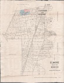
Map - MAP. ELMORE COUNTY OF BENDIGO, 1918
Map. Elmore County of Bendigo. Diggorra. Burnewang. Ryunnymead. Egerton Photo-Lithographed at the Department of lands and Survey Melbourne, by W. J. Button. 4.7.18 -
 Warrnambool and District Historical Society Inc.
Original Document, Map: Agricultural area of Ballangeich 1865, 1865
George Eddington arrived in Australia in 1839 and named and established property in 1841 calling the property Ballangeich after a Pass near his home town of Stirling in Scotland. It is situated 151 miles west of Melbourne and to the south of Mortlake and was originally part of the Mortlake shire, which was proclaimed 26th Jan 1864. Nearest streams are the Hopkins Riverand Lyall and Drysdale creek running through good agricultural land. This map relates to the breaking up of large runs which the Victorian government enabled through selection acts of the 1860's. The previously larger runs which were mainly cattle and sheep based were now more open to closer settlement and a greater variety in farming.The lots range in size from approximately 50 acres to around 600 acres.Some areas are set aside for reserves. By 1886 the population of Ballangeich had grown to around 600 with an hotel, three state schools and a church.Tri weekly coaches ran to Colac, Warrnambool and Camperdown providing access to supplies mail and communication. This map is typical of many which were produced in the 1860's in Victoria during a significant period of Victoria's and Warrnambool district history.Rectangular light card paper with black text showing allotments of land The area is coloured in green with scale at bottom right cornerAt the top: Plan of the Agricultural area of Ballangeich 1865 At the bottom left: Prepared by the Board of Lands & Works in accordance with the Amending Land Act 1865 Lands & Survey Office Melbourne 13th April 1865. With signaturehistory of warrnambool, ballangeich, land surveys victoria 1865, lands act 1865 victoria, ballangeich map 1865 -
Federation University Art Collection
Work on paper - Digital Prints, Gilson, Deanne, 'Wadawurrung Axe Heads 1-4' by Deanne Gilson, 2011
Dr Deanne GILSON (1967- ) Country: Wadawurrung Deanne Gilson is a Federation University alumni, and an award-winning multi-disciplinary artist. Her practice draws its inspiration from ‘Ancestral marks’ and design on cultural objects found in museum archives and family oral histories. Deanne’s practice seeks to interrogate the colonial legacy of settlement and the western hegemonic systems of class, race and representation in historical photographs that were imposed on her Ancestors. Her work also explores the matriarchal role through her feminist perspectives, looking at the history of marriage and the oppressive function it has played within her family. Deanne has completed the following educationala achievements. 2014 – 2015 Masters by Research (Visual Art), Deakin University Geelong 2013 Graduate Diploma in Education Secondary, Federation University 2011 Certificate IV in Aboriginal Contemporary Art & Craft 2010 Cultural Heritage Management Course, Lakes Entrance 1 Week 2007 – 2010 Graduated, Bachelor of Visual Arts with Honours, University of Ballarat 1984 Diploma of Art, School of Mines & Industries TAFE This item is part of the Federation University Art Collection. The Art Collection features over 2000 works and was listed as a 'Ballarat Treasure' in 2007.This work depicts an axehead found on Wadawurrung country and is a responce to workign alongside archeologists untertaking land surveys of her ancestral lands and the visual documentaiton of artefcts.art, artwork, deanne gilson, gilson, wadawurrung, stone axe, aboriginal, alumni -
 Port Melbourne Historical & Preservation Society
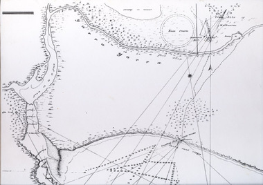
Map - Track, Sandridge to Melbourne, 1840
Bromide of surveyor's sketch of the track to Melbourne from Sandridge (Liardet's Beach), 1840. Originals with Lands Department, Melbourne. (possibly the work of William Wedge DARKE?)Slight processing stain upper right, '6' on backbusiness and traders - hotels, william wedge darke, piers and wharves -
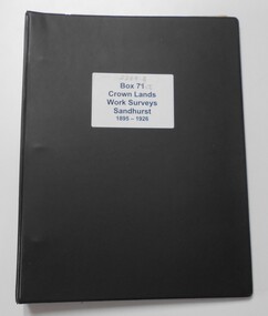 Bendigo Historical Society Inc.
Photograph - CROWN LANDS WORK SURVEYS 1895 - 1926
Black folder contains 14 buff coloured foolscap booklets in individual plastic pockets, listing crown lands work surveys in Bendigo. Pages are handwritten.hospital, bendigo, crown lands work survey, surveying, land -
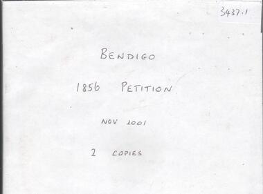 Bendigo Historical Society Inc.
Document - CD OF BENDIGO 1856 PETITION, 1856
CD. Bendigo 1856 Petition. Original Petition from Sandhurst occupants to Major General Macarthur seeking to improve lands. See 1085, Box 500.bendigo, law, land improvements -
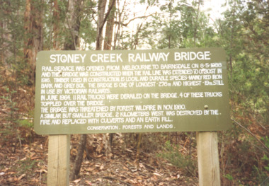 Lakes Entrance Historical Society
Photograph, Davies Judy, Stoney Creek Bridge Nowa Nowa Victoria, c1990
Colour photograpf of the sign erected by the Conservation, Forests and Lands Dept. at the Stoney Creek Bridge Nowa Nowa Victoria . Plus two other photos of the bridgebridges, forestry, tourism, topography -
University of Melbourne, Burnley Campus Archives
Plan, Plan of the Melbourne Botanic Gardens, 1948
Partially coloured plan on a grid. Prepared from Field Notes of Survey by F.C. Ridoutt drawn and reproduced at the Dept. of Lands & Survey, Melbourne, March 1948.f.c. ridoutt, gardens, melbourne, royal botanic gardens melbourne -
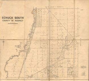 Bendigo Historical Society Inc.
Map - JACK FLYNN COLLECTION: ECHUCA SOUTH, 13/08/1931
Map: Parish of Echuca South, County of Rodney. Parish plan.By Authority H. J. Green, Govt. Printer. Department of Lands and Survey, Melbourne. 13.8.31map, rodney, parish plan, echuca south , county of rodney -
 Bendigo Historical Society Inc.
Map - JACK FLYNN COLLECTION: KARA KARA, 1932
Map: County of Kara Kara, map sheet showing the whole of the County of Kara Kara and all of the Parishes within. Scale 2 miles to 1 inch.By Authority: W.M. Houston, Government Printer Melbourne. Department of Lands and Survey, Melbourne, 1958map, kara kara, county, kara kara -
 Bendigo Historical Society Inc.
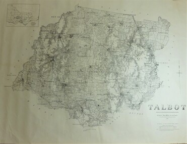
Map - JACK FLYNN COLLECTION: TALBOT, 1937
Map: County of Talbot, map sheet showing the whole of the County of Talbot and all of the Parishes within. Scale 2 Miles to 1 inch.By Authority: A.C. Brooks, Government Printer, Melbourne. Department of Lands and Survey Melbourne. 1959map, talbot, county, talbot -
 Bendigo Historical Society Inc.
Map - JACK FLYNN COLLECTION: COUNTY OF GLADSTONE, 1934
Map: County of Gladstone, map sheet showing the whole of the County and the Parishes within. Scale 2 Miles to 1 inch.Engraved at the Department of Lands and Survey Melbourne. 1958. By Authority of W.M. Houston, Government Printermap, gladstone, parish plan, gladstone -
 Vision Australia
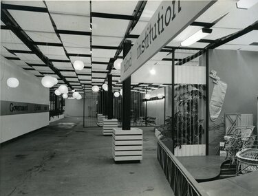
Photograph - Image, Queensland Blind Institution display at exhibition, 1962?
Part of a display by the Queensland Blind Institution (?) as part of a exhibition. Neither the full name of the organisation nor the exhibition are known, however a sign on the opposite wall reads "Government Exhibit 1962". Cane chairs, an ironing board cover, coat hangers, a cane cot and a cane screen are viewable to the far right of the image. The remaining view is of an empty space awaiting exhibitors.1 x B/W photograph of exhibition spaceC2-4138 Reproduced by Photo Section, Survey Office, Dept. Public Lands, QLD.queensland industrial institute for the blind, fundraising -
Clunes Museum
Administrative record - BOOK, GARDEN LICENCE 5/
RECEIPT BOOK. DEPARTMENT OF LANDS AND SURVEY. LICENCE TO ENTER UPON CROWN LANDS NOT EXCEEDING IN AREA ONE ACRE AS SPECIFIED, HEREUNDER FOR PURPOSE OF GARDEN AND RESIDENCE.BLUE COVERED RECEIPT BOOK CONTAINING PAYMENTS FOR GARDEN LICENCE NOd 188181 TO 188200 DATED MARCH 1885 TO NOVEMBER 1885local history, local gov., council, licence, garden -
 Federation University Historical Collection
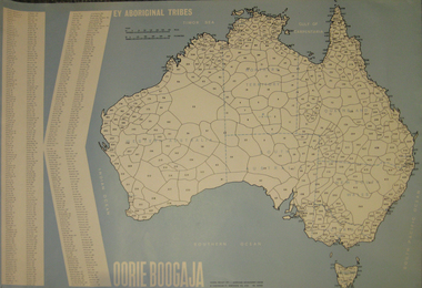
Poster, Key Aboriginal Tribes, 1971, 1971
Large blue poster with the shape of Australia depicted in white. Tribal lands have been placed onto the plan with numbers relating to names listed on the left of the poster.aborigine, aboriginal, aboriginal tribes, aborigines advancement league, koorie, wadawurrung, dja dja wurrung