Showing 1318 items matching "layout"
-
 Ringwood and District Historical Society
Map - Plan of Subdivision, Part of Crown Allotment 43, Parish of Ringwood, County of Mornington - (Circa 1950)
Copy of land title map in manilla folder showing layout and size of seven residential allotments (Lots 1 to 4 and 17 to 19) in Canterbury Road Heathmont, north-east of Bedford Road corner.Ronald G. Lee Licensed Surveyor, 195 Bridge Road, Richmond. Tel 42-6356. -
 Bendigo Historical Society Inc.
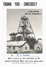
Document - CENTRAL DEBORAH MINE
5 pieces of information/advertising material for the Central Deborah Mine. A. Thankyou card presented to A. Richardson in appreciation of assistance with restoration of the mine. B&C. Diagram of the layout of the mine area, including highlights of underground tours, Key dates of the mine history and a map key to layout on the front of the pamphlet. D&E. Complimentary copy of a guide to the Central Deborah Gold Mine, showing the layout of the area and a description of each numbered site at the site. F&G. Advertising brochure, similar to the previous copy, D&E, with numbered locations at the site, and descriptions of each site. Includes additonal information re, Room 2 (change room) and Model room. H&I. Pamphlet of the mine area, showing chronological history, and short description of theach numbered site.gold mining, miners' safety cage, central deborah mine. -
 Bendigo Historical Society Inc.
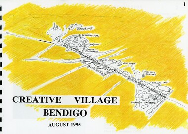
Book - MERLE HALL COLLECTION: ROSALIND PARK CREATIVE VILLAGE BENDIGO PROJECT BOOK, 1995
Merle Hall Collection: Rosalind Park Creative Village Bendigo Project Book. August 1995 Book contains a description, aims of the programme and a linking plan. 35 Pages: Cover Intoduction, The Design Team, Acknowledgement Project Brief Map of Linked Park The Linking Plan described Linking plan graphic Golden Beacon Design Concept Bridge Beacon Entrance to Linear Park Gasworks Café Pavillion Gasworks layout plan Golden Beacons Concept Botanical Gardens Café Botanical Gardens layout plan Victoria Hill Interpretation Centre Victoria Hill layout Victoria Hill plan Victoria Hill continued Victoria Hill continued Rosalind Park Lookout Method 3D Road Map 3D Road Map Continued Implementation Community Participation Oppurtunities, Mosaic Works Appropriate sites Appropriate sites continued Consultaion Summary and Issues Ideas Areas for further consideration Graphic The Design Team - Grant Fink, Jane Marriott, Laszo Biro, James Brearley Graphic Layoutbook -
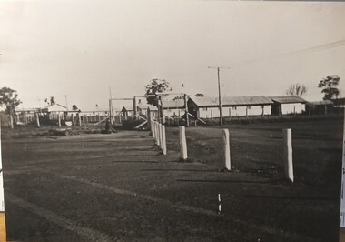 Tatura Irrigation & Wartime Camps Museum
Photograph, Camp 3
Shows some of the layout of camp 3 huts and fences.Black and white photograph of some huts behind a dividing fence, with an entrance. In front of that is a row of white posts. Power poles running through on an angle.camp 3, camp 3 huts, gerd aberle -
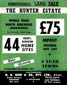 Ringwood and District Historical Society
Flyer, Land Sale Brochure, The Hunter Estate, North Ringwood, Vic. - circa 1960
Bi-fold land sale advertisement for The Hunter Estate, North Ringwood, including terms of sale, area map, layout of the estate, and summary of local facilities and services, with separate attachment listing lot number prices.Subdivision includes Wonga Road, Hunter Avenue (later Graeme Avenue), Panfield Avenue, Hendra Grove, and Mullum Mullum Road. Agent - N.R. Reid & Co. Pty. Ltd., Station Entrance, Ringwood. (Phone) WU 6661. -
 Federation University Historical Collection
Book, A Descriptive Catalogue of the Minerals in the Museum of the School of Mines, Ballaarat, 1882, 1882
The Museum of the Ballarat School of Mines was established in 1872. The curator in 1882 was Ferdinand M. Krause. Prefatory Notice by James Oddie). The want of a guide through the technical collections of The School Mines has long been felt by visitors and students - a guide , not so much to those who merely 'look' at the various exhibits in the Museum, but an instructor to those who desire to take away with them some practical information on the natural occurrence and economical value of the objects exhibited. This want is being filled by the labour of Mr. Krause, whose first installment - 'A Descriptive Catalogue of the Minerals' - is herewith represented to the visiting public." Introduction to the catalogue: " The collection is still in its early growth, and far from being a complete representation of the Mineral Kingdom; many varieties, species, and even whole groups are absent. This state of incompleteness will, no doubt, be adjusted in the sequence, and progressive lists issued from time to time. 'Ad interin' the present catalogue will, be found useful to students and visitors of the School. As far as practicable, the classifications of the minerals accords with that adopted at the Royal School of Mines, London. The numbers prefixed to the species in the catalogue agree with those on the descriptive labels which accompany each specimen, and also with those attached to the specimens themselves. On the descriptive labels the chemical composition of the minerals is expressed in formulae usually employed in standard mineralogical works. Students who have note paid attention to mineralogical chemistry will note that each dot over a symbol is equivalent to one atom of oxygen, .... A bar through a symbol denotes a double atom of the base, .... " In 1882 the collection was housed in 33 cases. The catalogue outlines the specimen types housed in each case. The classification of minerals accords with that adopted at the Royal School of Mines, London. Leather covered book of 94 pages with gold lettering on the front, including "F.M. Krause". The book includes a plan of the museum layout, plan of the grounds and buildings of the Ballarat School of Mines and a prefatory notice by James Oddie.ballarat school of mines, ballarat school of mines museum, museum, krause, ferdinand krause, fm krause, oddie, james oddie, geology, mineralogy, charles boyd, f.m. krause, minerals, curator -
4th/19th Prince of Wales's Light Horse Regiment Unit History Room
Aerial Photographs, Broadmeadows Victoria camp?, late 1940's
A set of 30 aerial photographs of what could be Broadmeadows Victoria camp. Some show the terrain, others the camp layout and others of a tank regiment formed up in Squadrons. The majority of the tanks appear to be General Grantsairial photos, tank camp, broadmeadows -
 Ringwood and District Historical Society
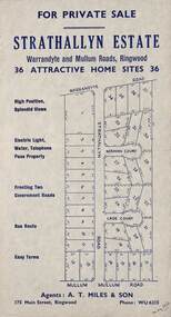
Flyer, Land Sale Advertisement - Strathallyn Estate, Ringwood, Victoria - circa 1950
Advertisement for private sale of 36 home sites in the Warrandyte Road and Mullum Mullum Road area of Ringwood, with map showing layout of subdivision and summary of local features and services. Handwritten notation indicates May, 1950.Subdivision includes Warrandyte Road, Strathallyn Road, Norman Court, Lade Court, and Mullum Mullum Road. Agents: A.T. Miles & Son, 175 Main Street, Ringwood, Phone WU6215. -
 Melbourne Tram Museum
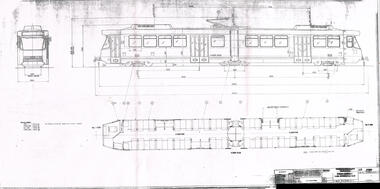
Drawing, Commonwealth Engineering - Comeng, "General Assembly T4000 Articulated Tram", 1987
Drawing - Commonwealth Engineering - Comeng - spread over two A3 sheets titled "General Assembly T4000 Articulated Tram", showing the layout and dimensions of the proposed tram, with the option of couplers. Became the B class tram.trams, tramways, mmtb, new tramcars, tramcar design, b class, comeng -
 Tatura Irrigation & Wartime Camps Museum
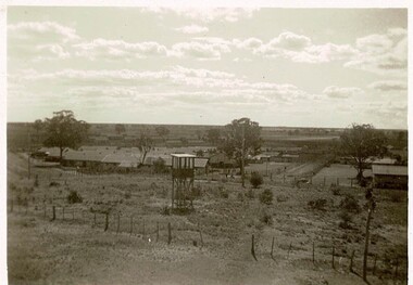
Photograph, Camp 3 View
Shows the layout of Camp 3. Larger duplicate of photograph in file.Black and white photograph of Camp 3 from up on a hill. Shows fence, guard tower and huts.camp 3 -
 Ringwood and District Historical Society
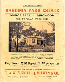
Flyer, Land Sale Brochure, Kardinia Park Estate, North Ringwood, Vic. - circa 1948
Folded buff-coloured land sale advertisement for Kardinia Park Estate in Warranwood area of North Ringwood, including terms of sale, area map, layout plan of the estate, and summary of local facilities and services. Front page features photograph of a man and dog in front of a house captioned as Lot 1 on four acres shown on the estate layout as cnr of Brysons Road and Range View Parade (later Omeo Parade). Second page includes bushland swimming pool photograph and promotional information for prospective buyers.Subdivision includes Kardinia Crescent, Wonga Road, Brysons Road, Range View Parade (later Omeo Parade), Motor Coach Road (later Wonga Park Road, then Warranwood Road). (Agent/s) T.A.W. Burkitt, Main Street, Ringwood, Phone (9 to 6) Ringwood 242, Evenings, Ringwood 157, and J. McEwan & Co, 317 Collins Street, Melbourne, Phone 6750 Central. -
4th/19th Prince of Wales's Light Horse Regiment Unit History Room
Booklet (3 copies), US Government Printing Office, Browning Machine Gun Caliber 0.50 HB M2, Dec 1955
Soft covered booklet which arranges a step by step progressive training layout of familiarisation, mechanics, crew drills and techniques of fire of the gun. Two copies have Appendix VII, Designation Crews. Printed in May 1956FM 23-6550 caliber machine gun -
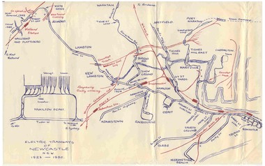 Ballarat Tramway Museum
Map, Ken McCarthy, Electric Tramways of Newcastle 1923 - 1950, c1960
Hand drawn red and blue biro map of Newcastle electric tram lines - period 1923 - 1950, showing principal railway lines, tram tracks, crossovers depot layout, level crossings on plain foolscap paper.trams, tramways, newcastle, steam trams, trams, map -
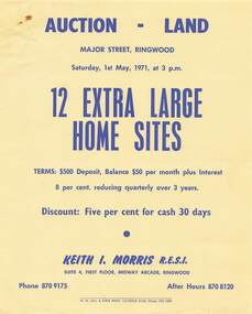 Ringwood and District Historical Society
Flyer - Land Auction, Major Street Ringwood - 1971
Single yellow page with blue print advertising auction of twelve home sites on Saturday 1st May, 1971. Details include vendor terms. Photocopied map of Major Street attached showing layout and dimensions of allotments.Agent: Keith I. Morris R.E.S.I., Suite 4, First Floor, Midway Arcade, Ringwood, Phone 8709175, after hours 8708120. -
 Eltham District Historical Society Inc
Negative - Photograph, J.A. McDonald, Hurstbridge Water Scheme, 11 May 1961
Showing layout of weir http://wikimapia.org/10473910/Running-Creek-ReservoirRecord of various Shire of Eltham infrastructure works undertaken during the period of 1952-1962 involving bridge and road reconstruction projects, sometimes with Eltham Shire Council Project Reference numbers quoted. It was during this period that a number of significant improvements were made to roads and new bridges constructed within the shire that remain in place as of present day (2022). In many situations, the photos provide a tangible visible record of infrastructure that existed throughout the early days of the Shire. The album was put together by or under the direction of the Shire Engineer, J.A. McDonald.infrastructure, road construction, shire of eltham, 1961-05-11, hurstbridge water scheme -
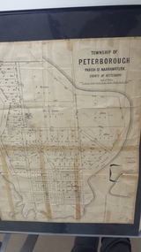 Peterborough History Group
Map - Map of the township of Peterborough, Township of Peterborough
Undated but indicative of the layout of the town. includes printed notes regarding the landscape and flora.Old map of the township of Peterborough from J S Irvine.A3 size paper map with tape around the sides. Includes handwritten notes.Handwritten on the rear is J.S Irvinepeterborough, old maps -
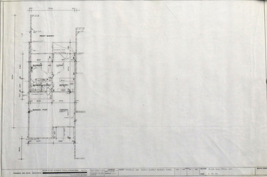
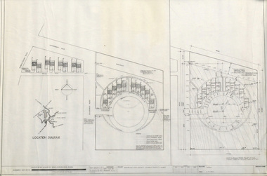 Robin Boyd Foundation
Drawing - Architectural, Monbulk & District Elderly Peoples Homes, Feb-75
Project: drawn by Leslie Jones of Romberg & Boyd. Site Plan and Complex LayoutWorking Drawing, Ink on Tracing Paper -
 Robin Boyd Foundation
Drawing - Architectural, Monbulk & District Elderly Peoples Homes, Feb-75
Project: drawn by Leslie Jones of Romberg & Boyd. Site Plan and Complex LayoutWorking Drawing, Ink on Tracing Paper -
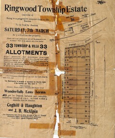 Ringwood and District Historical Society
Flyer, Auction Sale Advertisements - Ringwood Township Estate, Ringwood, Victoria - 1914
Advertisements for auction sale of Ringwood Township Estate (Section A) - Saturday, 7th March (1914), showing subdivision layout, terms of sale, and summary of local features and services. Un-named newspaper clipping advertising this auction also attached.Subdivision includes West Prussia Road (later Wantirna Road), Station Street, and James Street. Agents in conjunction - Coghill & Haughton and J.B. McAlpin. Sale by order of Mrs. E. Kendall. -
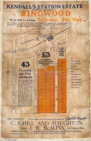 Ringwood and District Historical Society
Flyer, Auction Sale Advertisements - Kendall's Station Estate, Ringwood, Victoria - 1914
Advertisements for auction sale on Saturday, 9th May (1914) 43 township and villa allotments directly opposite the railway station, showing terms of sale and subdivision layout. Un-named newspaper clipping advertising this auction also attached.Subdivision includes James Street and William Street (later Kendall Street), Ringwood. Agents in conjunction - Coghill & Haughton and J.B. McAlpin. Sale by order of Mrs. E. Kendall. -
 Bendigo Historical Society Inc.
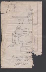
Document - BILL ASHMAN COLLECTION: SCALEBUOY DIAGRAM
Lay Out of Scalebuoy at the Rochester Butter Factory drawn in pencil on a piece of paper with the bottom right corner missing. Lay Out includes measurements, pump base, 2 valve houses, front and side walls and pipe layout.sciences, instruments - general, scalebuoy, bill ashman collection - correspondence, rochester butter factory lay out -
 Robin Boyd Foundation
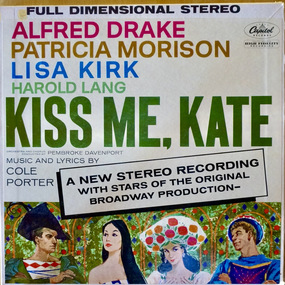
Audio - Recording, Capitol Records
The Boyds purchased their record player and sound system from Thomas’s in Melbourne. Patricia Boyd (later Davies) was very interested in opera and was later appointed to the Board of the Australian Opera.Kiss Me, Kate. LP 33RPM vinyl, Catalogue Number: STAO 1267, Double layout cover 1 vinyl disc, inside cover notes by Miles Kreuger. Cole Porter, Orchestra and chorus conducted by Pembroke Davenport.lp, sound recording -
 Tennis Australia
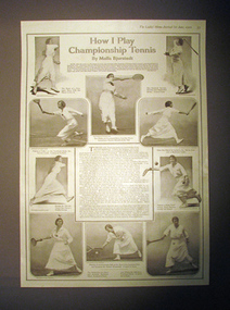
Page from Magazine, 1916
Magazine article: 'How I play championship tennis'. Page 33 from Ladies Home Journal (U.S) June 1916 issue. Layout with images of and text by tennis player Molla Bjurstedt, entitled Materials: Paper, Inktennis -
![Cr. H.F. Mogg, Mayor [of Kew] 1939-40](/media/collectors/550653872162f11fb04854aa/items/5922bdded0cde3131ca24883/item-media/5c1ec47321eabe0988e12091/item-fit-380x285.jpg) Kew Historical Society Inc
Kew Historical Society IncPhotograph, C Stuart Tompkins ARPS, Cr. H.F. Mogg, Mayor [of Kew] 1939-40, 1939
Kew achieved independence from the Boroondara Roads Board in 1860. As a new municipality, its first three leaders were designated as chairmen. On becoming a borough in 1863, its leaders were identified as mayors. The earliest photographs date from ca.1906, when the Town of Kew commissioned the noted local photographer Josiah E Barnes to produce standardised portraits of former mayors to be displayed in the Mayoral Chamber of the Town Hall. The collection also includes photographs by other well-known photographic studios such as Burlington Studios, Melba – Melbourne, Stuart Tompkins, Spencer Shier and Talma & Co. The majority of mounts identify the photographer. Eighty photographs are housed in their original frames.This portrait is one of a series of mounted and framed photographic portraits of mayors and town clerks of the former Borough, Town and City of Kew. The portraits were transferred by the City of Kew to the Kew Historical Society in March 1989. A Significance Assessment in 2018, funded by the National Library of Australia confirmed the historic, and often artistic significance of the series.Unframed portrait of Cr. Cr. H.F. Mogg, Mayor of Kew 1939-40. The photograph follows a typical layout or style in that it is laid down on an inscribed board. The inscription identifies the name of the mayor and the year/s that he/she served.Cr. H.F. Mogg / Mayor 1939-40 C Stuart Tompkins ARPSmayors of kew (vic), australian photographers - c. stuart tompkins a.r.p.s. - camberwell (vic), cr. h.f. mogg, kew (vic.) — municipal collection -
 Melbourne Tram Museum
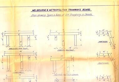
Drawing, Melbourne & Metropolitan Tramways Board (MMTB), "Plan showing types and sizes of overhead troughing in Depots", post 1964
Drawing - original dyeline print - folded into 16, showing dimensions and layout of the wooden troughing in 16 different sheds at the depot - e.g. old and new Malvern. Prepared July 1934. Drawing Number 06739A Revision A Feb. 1964trams, tramways, depot, overhead, trolley wire, trolley poles, electrical equipment -
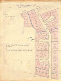 Ringwood and District Historical Society
Map - Plan of Subdivision, Part of Crown Allotment 27 & 27B, Parish of Ringwood - (Undated, circa late 1950s)
Copy of land title map in manilla folder showing layout and size of 60 allotments in Railway Avenue, Victoria Street, Smithdene Avenue, Richard Court, Jeanette Court, Bruce Court and Loma Street, Ringwood East, Victoria.Note: Lot 15 is to be transferred to the Ringwood Borough Council for use as a children's playground. Map includes handwritten sales notations for several allotments, e.g. Sold. -
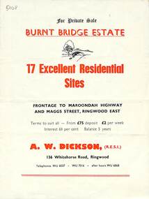 Ringwood and District Historical Society
Flyer, Land Sale Brochure, Burnt Bridge Estate, Ringwood East/Croydon, Vic. - circa 1959
Bi-folded single sheet with black and red print both sides including subdivision features and local facilitiesSubdivision layout includes Marcus Road, Maggs Street and Maroondah Highway Croydon/Ringwood East. (Agent) A.W. Dickson, 136 Whitehorse Road, Ringwood, Telephones WU 6007, WU 7016, after hours WU 6868. -
Creswick Campus Historical Collection - University of Melbourne
Map, 1923
Includes detail of Plantation layout and plantings at the time and later plantings (1930's) in pencil.Map -
Vision Australia
Plan - Image, Vision Australia Kensington plans, 2009
Diagrams of seating and layout for the opening of Vision Australia's office in Macaulay Road, Kensington in 2009.Digital files of Macaulay office fit outvision australia, plans -
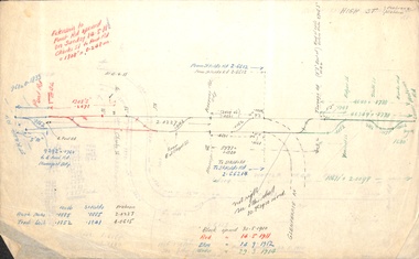 Melbourne Tram Museum
Document - Research Notes, H. S. McComb, Extracts of PMTT Minutes - track layouts, 1950's
Set of papers, handwritten concerning the development and timing of the "PMTT", Prahran and Malvern - 6 sheets. Prepared by H. S. McComb - gives layout of the PMTT system, primarily of Burke Road, sketches of track layout, opening dates, sketches of various junctions, bridges, track miles, junctions, reconciliation of track lengths from various sources of High St Malvern, extension to Punt Road and St Kilda Roads includes duplications and a Wattle Tree Road. Items 2041 to 2052 within box 72.3 in a brown folder marked "PMTT" in red pencil.trams, tramways, pmtt, malvern, routes, track, surveys, punt rd, high st, wattle tree rd, duplications