Showing 50731 items matching "melbourne photographs"
-
 Ringwood and District Historical Society
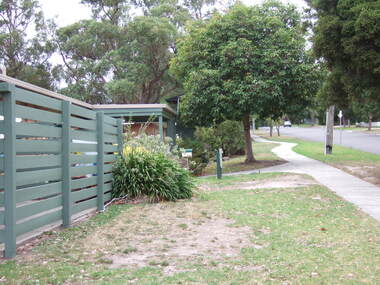
Photograph, Knaith Road Child Care Centre, Ringwood East, showing driveway to rear reserve in January 2007
-
 Ringwood and District Historical Society
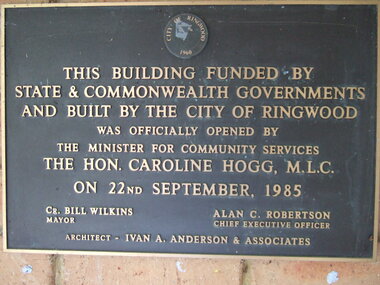
Photograph, Knaith Road Child Care Centre, Ringwood East, plaque offically opened on 22nd September 1985 by Hon. Caroline Hogg MLC
Mayor Cr Bill Wilkins of City of Ringwood, Chief Executive Officer, Alan Robertson, architect Ivan A Anderson & Associates -
 Ringwood and District Historical Society
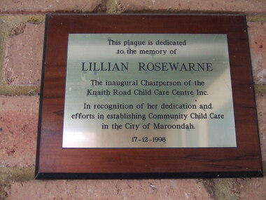
Photograph, Knaith Road Child Care Centre, Ringwood East, plaque dedicated to the memory of Lilian Rosewarne, inaugural Chairperson of the Centre
-
 Ringwood and District Historical Society
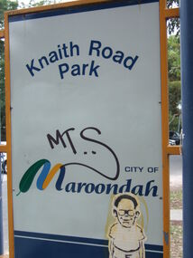
Photograph, Knaith Road Park, Ringwood East, sign in January 2007
City of Maroondah -
 Ringwood and District Historical Society
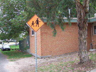
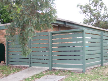
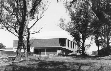
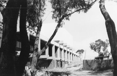
Photograph, Knaith Road Child Care Centre, Ringwood East, showing side view of building in January 2007
City of Maroondah -
 Ringwood and District Historical Society
Photograph, Knaith Road Child Care Centre, Ringwood East, eastern view of building in January 2007
City of Maroondah -
 Ringwood and District Historical Society
Poster, Land Sale Advertisement - Pinemont Estate, Ringwood, Victoria - circa 1924
Map of residential allotments for sale, with terms of sale, summary of subdivision features and local services and facilities, and photographs of local street scene and lake (Loughnan's Lake - location not marked), Subdivision includes Wonga Road (later Loughnan's Road), Glenvale Road, Kubba Road, Felix Crescent, Summit Crescent, Pine Crescent, Aurum Crescent, Hygeia Parade, Panorama Avenue, Avalon Grove, Montalbo Road, Cielterre Avenue. Sole Agents T.M. Burke Pty Ltd, 340 Collins Street Melbourne Phones 6294, 6779. Map by S. Callanan, Licensed Surveyor, 107 Elizabeth Street Melbourne. Date of poster estimated from railway services information extract " ... 36 fast electric trains to Flinders Street daily ... proposed electrification to Croydon ..." . Timeline for electrification of Lilydale Line record indicates Box Hill to Ringwood January 1923, Ringwood to Croydon November 1924 (Source: History of Croydon - McGivern, Vol.1 p20). -
 Ringwood and District Historical Society
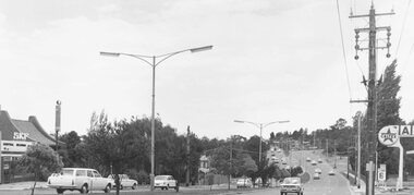
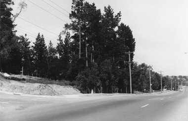
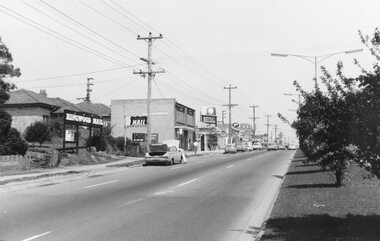
Photograph, Maroondah Highway East, Ringwood- 1971. Looking east towards Mt Dandenong Road
Black and white photographWritten on back of photograph: "Maroondah Highway, looking east towards Mt Dandenong Road turnoff past lake. 1971." -
 Ringwood and District Historical Society
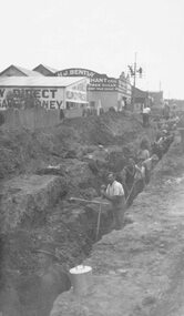
Photograph, Maroondah Highway East, Ringwood- c1920's. Excavation for new water main
Black and white photograph (2 copies- 1 large, 1 small)Written on rear of backing sheet: "Digging trench for water main along Maroondah Highway." -
 Ringwood and District Historical Society
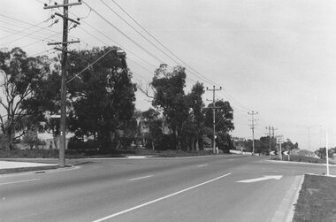
Photograph, Maroondah Highway East, Ringwood- 1965. Corner of Mt Dandenong Road before widening
Black and white photograph (3 separate images)Typed note on back of photograph: "M'dah Hwy, June 1965, before it was widened from Mt Dandenong on." -
 Ringwood and District Historical Society
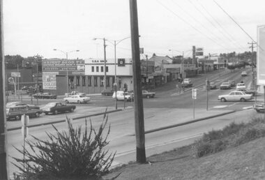
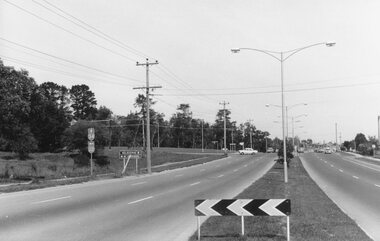
Photograph, Maroondah Highway East, Ringwood- 1976. Looking east from Warrandyte Road intersection
Black and white photographImage shows intersection with C.B.A. Bank on north east corner. Photograph taken mid 1976. -
 Ringwood and District Historical Society
Photograph, Maroondah Highway East, Ringwood- 1969. Looking west towards Ringwood from Everard Road
Black and white photographWritten on back of photograph: "Site of Cass's school, 1874. (1 acre left out of 5 acres). -
 Ringwood and District Historical Society
Photograph, Maroondah Highway East, Ringwood- 1969. New Civic Centre being built in Braeside Ave
Black and white photographWritten on back of photograph: "New municipal offices being built". -
 Ringwood and District Historical Society
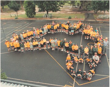
Photograph, Southwood Primary School staff and student photo forming map of Australia outline (undated) - circa 1997-8
colour photoSOUTHWOOD Primary School students and staff -
 Ringwood and District Historical Society
Photograph, Maroondah Highway East, Ringwood- 1969. New Civic Centre being built in Braeside Ave
Black and white photographWritten on back of photograph: "New municipal offices being built." -
 Ringwood and District Historical Society
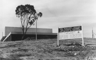
Photograph, Maroondah Highway East, Ringwood- 1969. New Civic Centre being built in Braeside Ave
Black and white photographSign on construction site reads: New Municipal Offices and Council Chamber for the City of Ringwood. Also shows names of Architects and other Contractors. -
 Ringwood and District Historical Society
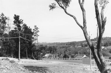
Photograph, Maroondah Highway East, Ringwood- 1969. View looking north from Civic Centre towards Norwood High School
Black and white photographWritten on back of photograph: "Norwood High from Civic Centre, Nov 1969." -
 Ringwood and District Historical Society
Photograph, Maroondah Highway East, Ringwood- 1969. Looking towards Mullum Road oval from Civic Centre
Black and white photographWritten on back of photograph: "From Civic Centre looking across Mullum Road oval, Nov 1969." -
 Ringwood and District Historical Society
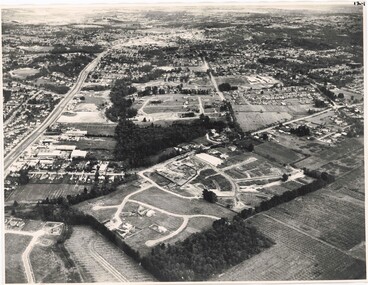
Photograph, Composite Aerial Views of Ringwood, Victoria - 1972
Two composite black & white aerial photographs with north-facing view over Maroondah Highway, including Railway Station precinct, Civic Centre precinct, Eastland, Mount Dandenong Road, Bedford Road, Ringwood Street, Warrandyte Road, Mullum Road, Loughnan's Road.Department of Crown Lands and Survey. Maroondah Highway Project - Run 3 - 20.1.72 - 3,900' ASL. -
 Ringwood and District Historical Society
Photograph, Aerial View of Ringwood, Victoria - circa 1970
Black & white west-facing view over Oban Road along Mullum Mullum Road and Creek. Foreground showing early subdivision development of "Dunn's Orchard Estate" with formation of Frederic Drive (named after the orchardist - Frederic Dunn), Baron Court, Towerhill Drive, Tyson Court, Adele Court, Marilyn Crescent, Abbey Court, Highland Boulevard, Ailsa Court. -
 Ringwood and District Historical Society
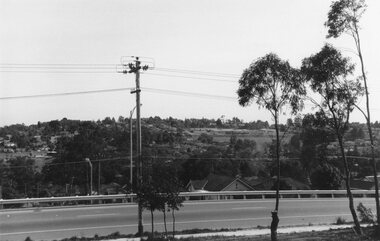
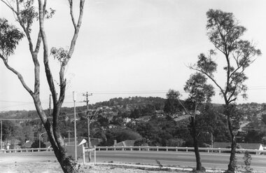
Photograph, Maroondah Highway East, Ringwood- 1969. View of Loughnan's Hill from Civic Centre
Black and white photographWritten on back of photograph: "Loughnan's Hill from Civic Centre. Nov 1969. -
 Ringwood and District Historical Society
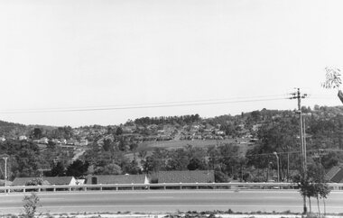
Photograph, Maroondah Highway East, Ringwood- 1969. Looking north from Braeside Ave towards Loughnan's Hill
Black and white photographWritten on back of photograph: "From Civic Centre, Nov 1969. -
 Ringwood and District Historical Society
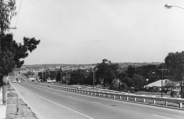
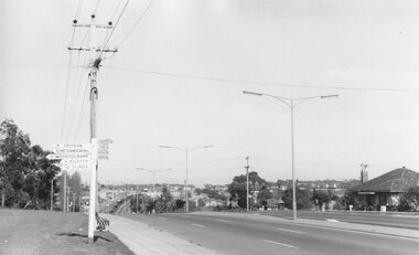
Photograph, Maroondah Highway East, Ringwood- 1969. Looking west towards Ringwood from Civic Centre
Black and white photographWritten on back of photograph: "Ringwood from Civic Centre." -
 Ringwood and District Historical Society
Photograph, Maroondah Highway East, Ringwood- 1969. Looking west towards Ringwood from Braeside Ave corner
Black and white photographWritten on back of photograph: "Nov 1969, cnr of Braeside Ave and Maroondah Highway." -
 Ringwood and District Historical Society
Photograph, Maroondah Highway East, Ringwood- 1969. Looking west towards Ringwood from Mt Dandenong Road intersection
Black and white photographWritten on back of photograph: "Nov 1969, Cnr Mt Dandenong Road and Maroondah Highway." -
 Ringwood and District Historical Society
Photograph, Maroondah Highway East, Ringwood- 1969. Looking west towards Ringwood from Mt Dandenong Road
Black and white photographWritten on back of photograph: "Cnr Maroondah Highway and Mt Dandenong Road. Nov 1969." -
 Ringwood and District Historical Society
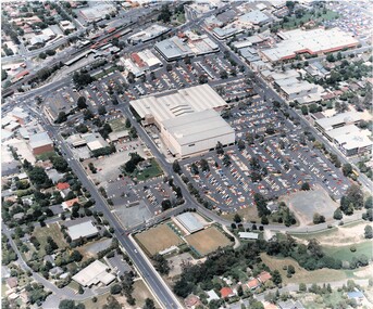
Photograph, Aerial Views of Eastland Precinct, Ringwood, Victoria - circa 1990
Two colour aerial photographs overlooking commercial area of Ringwood centred on Eastland shopping precinct (prior to Stage 2 extension proposed to commence in 1992).Aerial Photography by R.J. Moss. -
 Ringwood and District Historical Society
Photograph, Maroondah Highway East, Ringwood- 1969. Looking west towards Ringwood up from Ringwood Lake
Black and white photographImage shows Ringwood Mail Office on south side of Highway. -
 Ringwood and District Historical Society
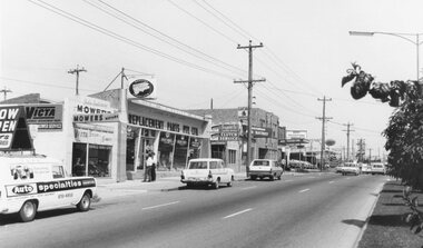
Photograph, Maroondah Highway East, Ringwood- 1969. Looking towards Ringwood from 'Repco' premises
Black and white photographImage shows businesses on south side of Highway, including John Salisbury Mowers, Repco, Maroondah Auto Electrics, Chemist, and Alan Coffey Motors used cars. -
 Ringwood and District Historical Society
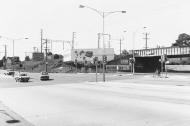
Photograph, Maroondah Highway East, Ringwood- 1969. Looking east from Warrandyte Road railway bridge
Black and white photographWritten on back of photograph: "May 1969, Site of first clock tower."