Showing 384 items matching "mining plan"
-
 Ballarat Heritage Services
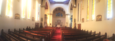
Photograph, Clare Gervasoni, Interior of Sacred Heart Kew, 01/03/2015
In 1872 members of the Jesuits purchased land in Walpole Street. Three years later, on 14 February 1875, Archbishop Gould laid a foundation stone for a school. By 1899 the land for the current church was purchased after mining speculator and Mt Lyell 'Copper King' James Crotty donated 3,000.00 pounds. The foundation stone was laid on 15 December 1918 by Archbishop Mannix. The cost of constructing the domed church was 15,000.00 pounds. A Fincham and Sons organ was installed in 1927, and refurbished in 1977. NEW PRESBYTERY AT KEW. Plans have been prepared by Mr. R. Harper, architect and builder, for the erection of a new presbytery for the Rev. P. Rafferty, adjoining the Sacred Heart Church, Cotham-road, Kew. The new building, which will be in brick and of two stories, will be behind the present priests' residence, which will continue to be used until the new presbytery is completed. The cost will be £6000, and the work will be begun almost immediately. The old presbytery was purchased many years ago by the late Rev. Fr. P. O'Donohue from the late Mr. Smart for £3000, and the full amount of the purchase money was donated by the late Mr. James Crotty. At different times additions were made to the building, but the small rooms made it altogether unsuitable as a residence for three priests, and made remodelling impracticable. The new presbytery will be in keeping with the Church of the Sacred Heart and the surroundings on the elevated site. At one time the old Sacred Heart Church was in Walpole-street, Kew. (The Advocate, 09 December 1937) The whole of the estate of the late Jas. Crotty has now been realised ex cepting 4000 shares in the Mount Lyell Company and a small parcel of general mining shares. All the debts and legacies, including £10,000 to St. Patrick's and £3300 to the testator's parish church at Kew, and also probate duty, have been paid. On present values the Mount Lyell shares. are worth a total of £37,000, and at the present rate of dividends the return represents an income of about £2000 per annum. Over and above this there is a sum of between £20,000 and £30,000 available for investment, and this, together with the dividends brings the income of the estate up to about £3000 per annum. A sum of £1100 per annum will be absorbed in annuities under the terms of the will. Whatever amount is realised beyond the sum necessary to pay the annuities goes to Archbishop Carr for the church and charitable purposes until the death of the last annuitant, when the resi duary estate will be divided between the Little Sisters of the Poor (North cote) and St. Joseph's Home (Surrey Hills). (Launceston Examiner, 18 July 1899) Sunday last being the anniversary of tire opening of the Sacred Heart Church, Kew, the pastor, Rev. Fr. Manly, made a special appeal at the various Masses. The beautiful design for marble altar for the Lady Chapel, which is on view in the vestibule, continues to attract attention. The Children of Mary Sodality have kindly undertaken to provide it, and the president, Miss Frances O'Sulliv!an, 43 Rideway-avenue, Kew, will be pleased to receive and acknow r ledge subscriptions from clients of Our Lady. They may also be placed in box near Lady Altar. (The Advocate, 06 December 1923) NEW PRESBYTERY AT KEW. Plans have been prepared by Mr. R. Harper, architect and builder, for the erection of a new presbytery for the Rev. P. Rafferty, adjoining the Sacred Heart Church, Cotham-road, Kew. The new building, which will be in brick and of two stories, will be behind the present priests' residence, which will continue to be used until the new presbytery is completed. The cost will be £6000, and the work will be begun almost immediately. The old presbytery was purchased many years ago by the late Rev. Fr. P. O'Donohue from the late Mr. Smart for £3000, and the full amount of the purchase money was donated by the late Mr. James Crotty. At different times additions were made to the building, but the small rooms made it altogether unsuitable as a residence for three priests, and made remodelling impracticable. The new presbytery will be in keeping with the Church of the Sacred Heart and the surroundings on the elevated site. At one time the old Sacred Heart Church was in Walpole-street, Kew. (The Advocate, 09 December 1937) The whole of the estate of the late Jas. Crotty has now been realised ex cepting 4000 shares in the Mount Lyell Company and a small parcel of general mining shares. All the debts and legacies, including £10,000 to St. Patrick's and £3300 to the testator's parish church at Kew, and also probate duty, have been paid. On present values the Mount Lyell shares. are worth a total of £37,000, and at the present rate of dividends the return represents an income of about £2000 per annum. Over and above this there is a sum of between £20,000 and £30,000 available for investment, and this, together with the dividends brings the income of the estate up to about £3000 per annum. A sum of £1100 per annum will be absorbed in annuities under the terms of the will. Whatever amount is realised beyond the sum necessary to pay the annuities goes to Archbishop Carr for the church and charitable purposes until the death of the last annuitant, when the resi duary estate will be divided between the Little Sisters of the Poor (North cote) and St. Joseph's Home (Surrey Hills). (Launceston Examiner, 18 July 1899) Sunday last being the anniversary of tire opening of the Sacred Heart Church, Kew, the pastor, Rev. Fr. Manly, made a special appeal at the various Masses. The beautiful design for marble altar for the Lady Chapel, which is on view in the vestibule, continues to attract attention. The Children of Mary Sodality have kindly undertaken to provide it, and the president, Miss Frances O'Sulliv!an, 43 Rideway-avenue, Kew, will be pleased to receive and acknow r ledge subscriptions from clients of Our Lady. They may also be placed in box near Lady Altar. (The Advocate, 06 December 1923)Panorama of the interior of Sacred Heart Catholic Church Kew. sacred heart, kew, catholic church -
 Bendigo Historical Society Inc.
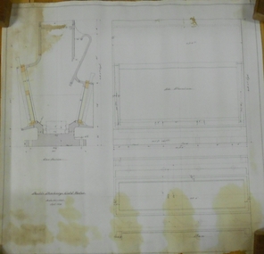
Plan - MARKS COLLECTION: DOUBLE DISCHARGE GOLD MORTAR
... MINING Equipment lansell mine ? Plan drawn on buff paper ...Plan drawn on buff paper, written on plan 'double discharge gold mortar' - no mine name given. Engineering drawings of gold mortar. 3 inches = 1 foot, September 1879.mining, equipment, lansell mine ? -
 Ballarat Heritage Services
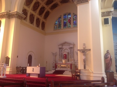
Photograph - Photograph - Colour, Clare Gervasoni, Sacred Heart Catholic Church, Kew. 2015, 01/03/2015
In 1872 membes of the Jesuits purchased land in Walpole Street. Three years later, on 14 Februrary 1875, Archbishop Gould laid a foundation stone for a school. By 1899 the land for the current church was purchased after mining speculator and Mt Lyell 'Copper King' James Crotty donated 3,000.00 pounds. The foundation stone was laid on 15 December 1918 by Archbishop Mannix. The cost of constructing the domed church was 15,000.00 pounds. A Fincham and Sons organ was installed in 1927, and refurbished in 1977. NEW PRESBYTERY AT KEW. Plans have been prepared by Mr. R. Harper, architect and builder, for the erection of a new presbytery for the Rev. P. Rafferty, adjoining the Sacred Heart Church, Cotham-road, Kew. The new building, which will be in brick and of two stories, will be behind the present priests' residence, which will continue to be used until the new presbytery is completed. The cost will be £6000, and the work will be begun almost immediately. The old presbytery was purchased many years ago by the late Rev. Fr. P. O'Donohue from the late Mr. Smart for £3000, and the full amount of the purchase money was donated by the late Mr. James Crotty. At different times additions were made to the building, but the small rooms made it altogether unsuitable as a residence for three priests, and made remodelling impracticable. The new presbytery will be in keeping with the Church of the Sacred Heart and the surroundings on the elevated site. At one time the old Sacred Heart Church was in Walpole-street, Kew. (The Advocate, 09 December 1937) The whole of the estate of the late Jas. Crotty has now been realised ex cepting 4000 shares in the Mount Lyell Company and a small parcel of general mining shares. All the debts and legacies, including £10,000 to St. Patrick's and £3300 to the testator's parish church at Kew, and also probate duty, have been paid. On present values the Mount Lyell shares. are worth a total of £37,000, and at the present rate of dividends the return represents an income of about £2000 per annum. Over and above this there is a sum of between £20,000 and £30,000 available for investment, and this, together with the dividends brings the income of the estate up to about £3000 per annum. A sum of £1100 per annum will be absorbed in annuities under the terms of the will. Whatever amount is realised beyond the sum necessary to pay the annuities goes to Archbishop Carr for the church and charitable purposes until the death of the last annuitant, when the resi duary estate will be divided between the Little Sisters of the Poor (North cote) and St. Joseph's Home (Surrey Hills). (Launceston Examiner, 18 July 1899) Sunday last being the anniversary of tire opening of the Sacred Heart Church, Kew, the pastor, Rev. Fr. Manly, made a special appeal at the various Masses. The beautiful design for marble altar for the Lady Chapel, which is on view in the vestibule, continues to attract attention. The Children of Mary Sodality have kindly undertaken to provide it, and the president, Miss Frances O'Sulliv!an, 43 Rideway-avenue, Kew, will be pleased to receive and acknow r ledge subscriptions from clients of Our Lady. They may also be placed in box near Lady Altar. (The Advocate, 06 December 1923)Colour photographs of the interior and exterior of Sacred Heart Catholic Church, Kew. sacred heart kew, church, kew -
 Flagstaff Hill Maritime Museum and Village
Photograph - Vessels, Sail and Steam Ships, c. 1972-1975
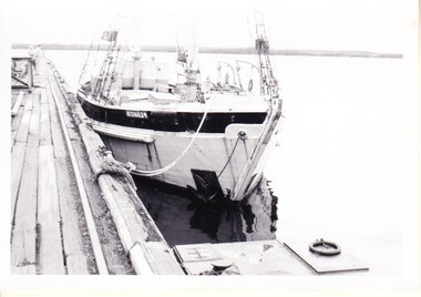
Andy Clapham owned and operated a boat yard on the Maribyrnong River in Footscray, Victoria. The river runs into Port Phillip Bay (sometimes known as Hobson’s bay) at Williamstown, an area with a history of trades associated with the shipping and construction industry. Andy Clapham’s photographs include those of the Reginald M and one of Polly Woodside, another vessel restored and used as a maritime exhibition. Andy Clapham’s letter of 1972 was posted in a and envelope with an early Australian decimal currency stamp showing the profile portrait of Queen Elizabeth II, and valued at 7 cent. Andy offered invaluable advice to the Flagstaff Hill Historic Park Planning Board regarding the purchase a vessel suitable for use as an exhibit once Flagstaff Hill was opened. The Planning Board was set up by the Warrnambool Chamber of Commerce and approved by the City Council and State Government. Flagstaff Hill was investigating vessels in Adelaide and Tasmania as well as Melbourne. Andy looked at several vessels in 1972-1973. He also serviced the Reginald M among other vessels belonging to Captain Julian Dyson of Yarra Ferries, who had casually offered the vessel to Flagstaff Hill as a price that was unattainable at the time. Flagstaff Hill later requested photographs of the hull to discern the dimensions and also the condition of the timbers as well as wanting advice on its seafaring capability. In 1972 the Flagstaff Hill Historic Park Planning Board – Chairman J. (John) S. Lindsay (1972-1980), Secretary J. (James) Mark – wrote a letter of appreciation to Mr A. (Andy) Clapham of 3 Charles Street Footscray ... “Dear Mr. Clapham, The Board has asked me to write to you to express our appreciation for the assistance you have offered us through our Chairman John Lindsay. The information you have already given us has been invaluable, in that is shows us that we have not been setting out to do something that is impossible. We look forward to receiving further information from you as it becomes available and we appreciate that you must be busy enough without our problems. Members of our Board hope to call and see you on a trip to Melbourne in the near future. The Board is optimistic about the future of Flagstaff Hill as a Maritime Museum and look forward to you visiting Warrnambool to examine what we believe will be an ideal site. Yours faithfully, James Mark.” ABOUT the vessel “Reginald M” The vessel “Reginald M” was a two-masted, timber coastal vessel built by John Henry Murch in Birkenhead, Port of Adelaide, South Australia. It was named after Reginald Murch. (It was occasionally referred to as the Reginald “Emm”). Its construction took approximately 6 months using many materials and fittings from salvage yards. It is believed that the keep was hewn from two telegraph poles! Reginald M was launched at Largs Bay in 1922. Reginald M was approximately 30 metres long and was fore-to-aft ketch rigged with an ‘auxiliary’ motor to support any loss of sail power. The Reginald M was built to service the coastal ports of South Australia to Port Victoria on the York Peninsular, Spencer Gulf. It freighted cargo from port to port cheaply and efficiently. It had a very shallow draft and a flat bottom, enabling it to come close to shore and sit high and dry at low tide, or to be beached on the sand. It could easily skim over reefs due to its flat bottom. Wagons could be loaded and unloaded directly from the side of the vessel. Over the years her cargo included guano, barley, wool, horses, cattle, timber, explosives, potatoes, shell grit and gypsum. The Murch brothers from Port Adelaide were owners of the Reginald M and Richard Murch as the Captain. On April 9, 1931, Reginald M weathered a large storm in St. Vincents Gulf, SA, suffering much damage; the mast snapped and the crew laboured for four hours to free it up by severing the mast and rigging. The crew patched it up and slowly returned to Port Adelaide with only a portion of the insured cargo being damaged. The crew members at that time were owner Mr John Henry Murch of Wells Street Largs Bay, Skipper Mr R Murch – John’s brother, Murray – son of Captain Murch and Seaman John Smith. At some stage it seems that the Reginald M was used as a Customs vessel “H.M.C. No. 3, Pt Adelaide” as shown in a photograph in Flagstaff Hill’s collection. In 1969 Reginald M’s last freight trip left Marion Bay, carrying grain, wool and explosives. In late 1970 it was sold to the Mount Lyall Mining and Railway Clompany and used as a barge to carry explosives. In 1972 The Navy League of Strahan, Tasmania, purchased the vessel for use by the Strahan Sea Cadet Unit at Macquarie Harbour; it was renamed “T.S. Macquarie”. (This plan did not come to pass.) In 1974 Mr Andrew Rennie of East Brighton, Melbourne, brought Reginald M for shipping purposes, He sailed it from Strahan to Melbourne, planning to use it for pleasure sailing. The Reginald M was later sold at auction to Captain Julian Dyson, owner of Yarra Passenger Ferries in Melbourne. Later in 1975 funds became available to Flagstaff Hill Maritime Village to purchase the Reginald M. It was then restored and used as an exhibit here for many hears. Flagstaff Hill’s collection also includes various objects related to the Reginald M: - Photographs of Reginald M over the years in various aspects of its use - a life buoy with the inscription of “Pt. Adelaide” - helm section that was removed and replaced during restoration - a bullet found in pieces of timber during the 1979 restoration ABOUT THE POLLY WOODSIDE On the bow in the Polly Woodside's photograph is the word "RONA". the Polly Woodside was built at Belfast in 1885. In 1904 the vessel was sold to A.H. Turnbull of New Zealand and renamed "RONA". The letter and photographs are significant for their association with the Reginald M, an Australian built coastal trader now on the Australian Register of Historic Vessels (number HV000562). The letter and photographs are also significant as part of both the history of Flagstaff Hill and the history of the vessel “Reginald M” that has been on display in the lake for many years. Objects retained from this boat are included in Flagstaff Hill’s collection of maritime history.Packet with photographs and negatives in a KODAK envelope. The photographs are of two sail and steam vessels; twelve (12) black and white photographs of the 'Reginald M', and one (1) colour photograph of the Polly Woodside, plus six (6) negative strips. Included int he packet is a letter in stamped and postmarked envelope addressed to Mr A Clapham of Footscray. The envelope postmarked 9 Dec 1972, with the Warrnambool postcode 3280, A 7c Australian postage stamp in attached to the envelope. They are associated with Flagstaff Hill’s acquisition of the vessel “Reginald M”. Envelope "9 DEC 1972 / 3280" Postage stamp "7c" "Australia" Inscriptions on one Reginald M;; "REGINALD M" and "Pt ADELAIDE H.M.C. No. 3" Inscriptions of the Polly Woodside; "RONA / MSC" "MHI / NO. 1" Ball point ink, reverse of photograph "POLLY WOODSIDE"flagstaff hill, warrnambool, shipwrecked coast, flagstaff hill maritime museum, maritime museum, shipwreck coast, flagstaff hill maritime village, great ocean road, vessel reginald m, reginald emm, t. s. macquarie, h.m.c. no. 3, pt adelaide, australian register of historic vessels (number hv000562), boat building trade, jack murch, john henry murch, birkenhead, port adelaide sa, largs bay sa, coastal trader south australia, 1920 ketch reginald m, marion bay produce, mount lyall mining and railway company, navy league of strahan, tasmania, melbourne ferry company, flagstaff hill historic park planning board, john lindsay, james mark, andy clapham of footscray, andy clapham boat builder, kodak photograph packet envelope, kodak super-size prints, kodak australia pty ltd, australian postage stamp 1972 - 7c -
 Bendigo Historical Society Inc.
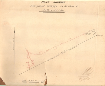
Document - MARKS COLLECTION: PLAN OF UNDERGROUND WORKING IN BALLERSTEDT & SON MINE, 28th November, 1965
Buff coloured document, heavy parchment, printed in black. On top of plan 'plan showing underground workings in the claim of Ballerstedt & Son.' Plan shows underground workings in red, with distances and angles. On bottom of drawing 'Ballerstedt's South Boundary'. Signed on bottom in black ink (indecipherable signature) and dated 28.11.65. Document attached is related to the donor Phillipa Marks' family and contains the recollections of her great grandfather in regard to Bendigo's Jewish community and synagogues.bendigo, mining, ballerstedt & son mine -
 Stawell Historical Society Inc
Map, Plan View Township Area showing Known old workings 2003, 13 June 2003
Coloured Printing outline of lease of Gold Mine Horizontal Drives shown in BrownStawell Gold Mine. Scale 1:7500. Fri 13 June 2003mining -
 Linton and District Historical Society Inc
Mining survey document, Mining Survey Document, 1890
... of the document. Mining applications Mining leases Plans Documents Isaac ...Document drawn up in relation to an application for a mining lease made by Isaac Walker of Linton. Application no. PP16, Lease no. 1351. Application was made for a mining lease on land in Sussex Street, Linton, which was occupied by Sarah Dawe and family. Original document is held at PROV Ballarat. Item and series details are recorded in handwriting on the lower part of the document.Photocopy of original document, which shows a plan of Allotments 3 & 4, Section 1A, Township of Linton, Parish of Argyle.mining applications, mining leases, plans, documents, isaac walker, dawe family, sarah dawe née carpenter -
 Bendigo Historical Society Inc.
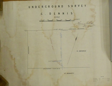
Plan - MARKS COLLECTION: PLAN OF UNDERGROUND SURVEY G. DENNIS MINE
... BENDIGO Mining g. dennis claim Plan drawn on heavy ...Plan drawn on heavy parchment 'underground survey G. Dennis' printed on top of plan. Plan shows boundary lines and peg site. P. Bonati claim marked on bottom of plan. B. Letter with plan on letterhead 'City of Sandhurst, Town Hall, July 2nd. 1873' Addressed to Mr. George Dennis, Sir, In reply to your letter of the 19th. ulto I am empowered to state that subject to the formation of the road referred to, your existing rights are conserved, and the council will undertake not to object to the renewal of your lease. The only conditions being that you shall not sink a shaft in the street or attempt to obstruct it when formed. I have the honor to be, Sir, your obedient servant, Geo Fletcher, Town Clerk.bendigo, mining, g. dennis claim -
 Bendigo Historical Society Inc.
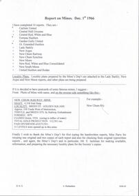
Document - MINING REPORTS - REPORT ON MINES DEC. 1ST 1966
Handwritten notes, with typed copy, listing 14 reports on mines and locality plans. If it was decided to have postcards of some famous mines, there is a suggestion of how they could be set out. Also a paragraph thanking the Mine's Dep't, Miss Parry and Mr. E. Jackman for work they have done.document, gold, mining reports, mining reports, report on mines dec 1st 1966, carlisle united, central nell gwynne, central red white and blue, fortuna hustlers, garden gully united, gt extended hustlers, lady barkly, new argus, new chum railway, new chum syncline, new moon, new red white and blue consolidated, south new moon, united hustlers and redan, mine's dep't, miss parry, mr e jackman -
 Bendigo Historical Society Inc.
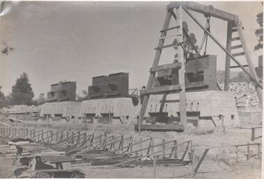
Photograph - Napoleon Reef Gold Mine Battery Site, 1936
The Napoleon (BML) gold mine (1932) was located near McDougall Road, Golden Gully, between Martin and Hattam Street. It had a depth of 921 feet. It was one of the latest and most lavish of Bendigo's mines. Plant and equipment were electrically driven. The four-compartment shaft, extra large by goldfield's standards, measured 17 feet 6 inches by 5 feet 2 inches and was cement lined below 900 feet instead of being red gum boxed as was the usual practice. The workshop was equipped to carry out all repairs for the equally lavish BML mines on the Nell Gwynne and Carshalton reefs. (The Gold Mines of Bendigo, Book 2, Arthur Victor Palmer) 'Napoleon BML Mines No Liability have issued a report for the fortnight ended September 5, where it states that the development scheme has been formulated and necessary equipment is being ordered. The Napoleon main shaft, (about 1700 feet south of the old Napoleon shaft) will be a four compartment shaft (17ft 6 inches by ft 2 inches inside the timber). aLevels will be opened at approximately 100 ft vertical intervals and cross-cuts extended approximately 125 ft each side of centre country to explore a cross-section across the anticline opposite to the shaft. At every fifth level, main drives will be extended north to connect with the old Napoleon shaft and south approximately 1800 ft. At the latter point, another cross-section of the anticline will be explored by rising and cross-cutting. The old Napoleon will be unwatered and on the 500ft and 1000 ft levels main drives will be driven to connect with main levels from the Napoleon main shaft to the south as well as being driven north 1800 ft where another cross-section of the anticline will be explored. Cross-sections further north and south may be developed as desired and also at intermediate points if necessary. Clearing and grading of the main shaft site are now in progress and the erection of the office and store building is proceeding. The design of engine room, change house and machine shops is now in hand and erection will proceed as soon as working plans and specifications are prepared.' The main shaft has been commenced at 3ft and advanced 10 ft. to 13 ft. https://trove.nla.gov.au/newspaper/article/10975478?searchTerm=napoleon%20bml (The Argus, 8th. September 1934, 'Mining' page 18) Significant to mining history of Bendigo.Black and white photograph of a stamper head being lowered into position on the battery site of the Napoleon Reef Gold Mine. A wooden gantry supports the battery head as it being lowered. Three large concrete foundations are visible in immediate background, two of which have stampers already in position, the third stamper is being lowered onto the final foundation. In immediate foreground, 'boxing' is erected for future concrete pours. napoleon gold mine, napoleon reef gold mine -
 Bendigo Historical Society Inc.
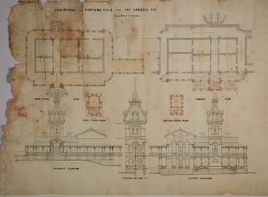
Plan - FORTUNA COLLECTION: FORTUNA VILLA
Originally built by Christopher Ballestedt (1796-1869) and his son Theodore. The Ballestedt's pioneered open cut and quartz mining on the Bendigo gold field. They were very successful. After Christopher's death, Theodore continued until 1871 when he sold Fortuna, their mines and equipment to George Lansell for 30,000 pounds.Four large plans of Fortuna villa. Scale 1:50 Australian survey office - Victoria Department of Administrative services. Fortuna Bendigo - Army Survey Regiment. Dept. of Defence - Army. Terrestrial Photogrammetric Survey. Project number: 8001/2. Reg. File: 64/531. Survey File:631. Draftsman: M.A. Osciak. Surveyed by G. Tucker. Date of Survey: 14/05/79. There are 4 large such plans in a plastic bag the measurement of the plans is approx. 115cm X 80 cm.plan, bendigo, fortuna villa -
 Bendigo Historical Society Inc.
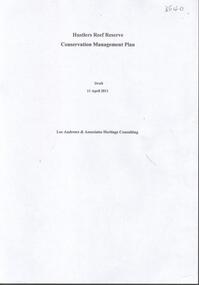
Document - HUSTLERS REEF RESERVE CONSERVATION MANAGEMENT PLAN
Conservation management plan (112 pages) prepared by Lee Andrews & Associates, Heritage Consultants, in 2011, for the Hustlers Reef Reserve. The reserve cover the site of the former Great Extended Hustlers Mine site. Leigh McKinnons amendments to the plan are included with the document. History of the site, a physical survey and analysis, comparative analysis, cultural significance and conservation policy are addressed in the document.bendigo, mining, great extended hustlers mine site -
 Bendigo Historical Society Inc.
Document - NEW CHUM & VICTORIA LINES OF REEF - NOTES ON VICTORIA HILL FOR TOURIST ATTRACTION
Handwritten notes outlining a plan for Victoria Hill, Central Nell Gwynne and New Chum Hill to be the focal position for a tourist attraction. Outlines steps to be taken to do the work and a mining museum at the Central Nell Gwynne. On the back of the page is a sketch of Victoria & New Chum Hills. On the plan is the Battery, Rae, Rae's House, Rae's Open Cut, Wittscheibe, Midway, Victoria Quartz, Lansell's 180 Shaft and the Recreation Reserve.document, gold, new chum & victoria lines of reef, central nell gwynne, new chum hill, bendigo and district tourist development association, victoria hill, lansell's big 180, victoria quartz, rae's open cut -
 Bendigo Historical Society Inc.
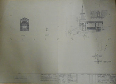
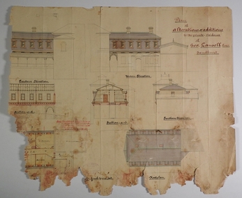
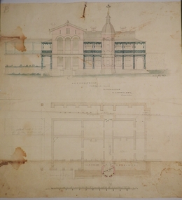
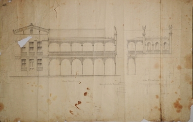
Plan - MARKS COLLECTION: PLAN OF ALTERATIONS AND ADDITIONS TO THE PRIVATE RESIDENCE OF GEO. LANSELL ESQR
Fortuna Villa was owned from 1855 to 1871 by Christopher and Theodore Ballerstedt, Australia’s first mining magnates. In 1871 it was purchased by George Lansell (The Quartz King) being one of Australia’s most successful and adventurous nineteenth century gold mine owners and speculators. Lansell made numerous alterations and extensions to the building. It remained in the Lansell family until 1935Plan for the alteration and additions to Fortuna Villaa, the private residence of George Lansell Plan shows southern, eastern & western elevations, floor and roof plan for the additions to the residence Coloured hand drawn construction plan Plan is undated plan has severe damage on LHS and bottom of the sheetfortuna villa, george lansell, building plans, c & t ballerstedt -
 Bendigo Historical Society Inc.
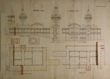
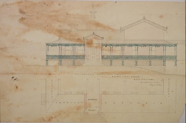
Plan - MARKS COLLECTION: PLAN FOR FOUR LEVEL STAIRCASE TOWER TO GARDEN ELEVATION AT FORTUINA VILLA FOR GEO. LANSELL ESQ
Fortuna Villa was owned from 1855 to 1871 by Christopher and Theodore Ballerstedt, Australia’s first mining magnates. In 1871 it was purchased by George Lansell (The Quartz King) being one of Australia’s most successful and adventurous nineteenth century gold mine owners and speculators. Lansell made numerous alterations and extensions to the building and it remained in the Lansell family until 1935.Plan for four level staircase tower to the Garden Elevation of Fortuna Villa, Sandhurst for George Lansell Esq. Plan details: * Plan shows ground, First, second and third floor plans for the staircase construction * First and second floor house plans and location of staircase addition * Front and Garden elevations with staircase addition Plan coloured and damaged on LHS, also with water damagebendigo fortuna villa, george lansell, building plans, c & t ballerstedt -
 Bendigo Historical Society Inc.
Plan - MARKS COLLECTION: PLAN FOR THE ADDITION OF A FOUR LEVEL STAIRCASE TOWER TO THE GARDEN ELEVATION OF FORTUNA VILLA FOR GEO. LANSELL ESQ
Fortuna Villa was owned from 1855 to 1871 by Christopher and Theodore Ballerstedt, Australia’s first mining magnates. In 1871 it was purchased by George Lansell (The Quartz King) being one of Australia’s most successful and adventurous nineteenth century gold mine owners and speculators. Lansell made numerous alterations extensions to the building and remained in the Lansell family until 1935Plan for the addition of a four level staircase to the Garden Elevation of Fortuna Villa for George Lansell Esq. Plan shows: * Four levels of the staircase cobstructiob - Ground, Principal, First & Second levels of the staircase tower, with viewing walk at the second level * Entrance & garden elevations section showing exterior of the four level additionfortuna villa, george lansell, c & t ballerstedt, building plans -
 Bendigo Historical Society Inc.
Plan - MARKS COLLECTION: PLAN FOR ADDITIONS TO FORTUNA VILLA FOR GEO. LANSELL ESQ. - STAIRCASE ADDITION
Fortuna Villa was owned from 1855 to 1871 by Christopher and Theodore Ballerstedt, Australia’s first mining magnates. In 1871 it was purchased by George Lansell (The Quartz King) being one of Australia’s most successful and adventurous nineteenth century gold mine owners and speculators. Lansell made numerous alterations extensions to the building and remained in the Lansell family until 1935Plan for the addition and necessary modifications of a staircase to Fortuna Villa, the residence of George Lansell Esq. Coloured plan Plan is damaged missing several sections on the LHS of the plan and has water damage in lower LH cornerfortuna villa, lansell, stair case -
 Bendigo Historical Society Inc.
Plan - MARKS COLLECTION: PLAN GARDEN FRONT FORTUNA VILLA SANDHURST - G. LANSELL ESQ., JULY 3RD 1871
Fortuna Villa was owned from 1855 to 1871 by Christopher and Theodore Ballerstedt, Australia’s first mining magnates. In 1871 it was purchased by George Lansell (The Quartz King) being one of Australia’s most successful and adventurous nineteenth century gold mine owners and speculators. Lansell made numerous alterations and extensions to the building and it remained in the Lansell family until 1935. Plan for construction of Fortuna Villa, Sandhurst Title: Garden Front, Fortuna Villa, Sandhurst for G. Lansell Esq. Dated: 3rd July 1871 Coloured plan and elevation Condition: water damage and paper tearsfortuna villa, george lansell, c & t ballerstedt, building plans -
 Bendigo Historical Society Inc.
Map - GREAT EXTENDED HUSTLER'S MINE - PLAN OF THE GREAT EXTENDED HUSTLER'S MINE
Plan of the Great Extended Hustler's Mine on the Hustler's Line of Reefs, Bendigo. Bulletin No 33, Plate No X. Lease No 7382. Plan has map of streets. Mine was located in the block bounded by Langston and Anderson Streets and was between the Hustler's Anticline at Surface and the Lightning Hill Anticline at Surface. Latham & Watson's Shaft is also mentioned. Levels are numbered and a table shows the Levels and their Depths. Geological Survey of Victoria. Signed by H A Whitelaw, Underground Survey Office, Bendigo, September 1913. This item has not been scanned or photographed.mining, parish map, great extended hustler's mine, hustler's line of reefs, mining lease no 7382, geological survey of victoria, underground survey office bendigo, h a whitelaw, latham & watson's shaft -
 Bendigo Historical Society Inc.
Map - GREAT EXTENDED HUSTLER'S MINE - PLAN OF THE GREAT EXTENDED HUSTLER'S MINE
Plan of the Great Extended Hustler's Mine. Bulletin No 33, Plate No XI. Shows No 2 Shaft, Latham & Watson's Shaft, levels and their depths and some geographical features. Geographical Survey of Victoria emblem and signed by H A Whitelaw, Underground Survey Office, Bendigo, September 1913. Has reference to photos.mining, parish map, great extended hustler's mine, no 2 shaft, latham & watson's shaft, geological survey of victoria, underground survey office bendigo, h a whitelaw -
 Bendigo Historical Society Inc.
Map - FORTUNA HUSTLER'S MINE - PLAN OF THE FORTUNA HUSTLER'S MINE
Plan of the Fortuna Hustler's Mine, Bulletin No 33, Plate No II. Geological Survey of Victoria. Signed by H A Whitelaw, Underground Survey Office Bendigo, September 1913. Map shows levels and depths. There are smaller drawings of some sections of some levels. mining, parish map, fortuna hustler's mine, plan of the fortuna hustler's mine, geological survey of victoria, h a whitelaw, underground survey office bendigo -
 Bendigo Historical Society Inc.
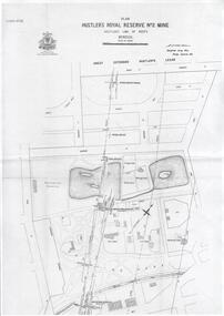
Plan - Hustler's Royal Reserve No. 2 Mine, April, 2014
One page plan (photocopy) of Hustler's Royal Reserve No. 2 Mine (Park Shaft) showing mine location, dams, tennis courts, bowling green, Jail (sic) Barnard Street, View Street and Park Road. Whitelaw plan, 1913.goldmining, accident, quartz, mining, hustler's royal reserve no. 2 mine, park shaft, hustler's line of reef, gaol, -
 Bendigo Historical Society Inc.
Document - Geological Survey of Victoria, Hustlers Line of Reef, Bendigo, April, 2014
Seven men were killed at the Great Extended Hustler's mine disaster on 2nd May 1914 by an explosion of dynamite occurring as the men were waiting at the plat to ascend the mine at the end of their shift. No blame was attached to anyone in the findings of the inquisition. It was unknown what caused the dynamite to explode. This document formed part of the research done at the time by Bendigo Historical Society, of the 100 years commemoration of the mine disaster, held at Hustler's Hill in 2014. Seven page photocopy of Department of Mines, Bulletin, Geological Survey of Victoria, Hustlers Line of Reef, Bendigo, No. 33 by H.S. Whitelaw. Includes plan of Hustlers Royal Reserve No. 2, (main shaft) showing location on Pall Mall, and location of Post Office and Law Courts; plan of location of Hustlers Royal Reserve No. 2 (Park Shaft) showing Jail (sic), Camp Hill State School, two 'lagoons' in between tennis court, croquet court and bowling green; a plan of the Great Extended Hustler's Shaft and two copied images of Hustler's Hill showing mining buildings, poppet heads and chimneys. Comet, K.K., Hustler's No. 1, Old Comet and United Hustler's and Redan Mines are shown in the images. great extended hustlers, goldmining, accident, quartz, mining, k.k. mine, comet mine, hustler's line of reef, old comet, united hustler's, redan -
 Bendigo Historical Society Inc.
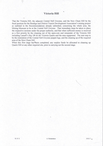
Document - VICTORIA HILL - VICTORIA HILL AND NEW CHUM HILL
... location, value of gold and plans for a mining museum.... Chum Hill. Notes give location, value of gold and plans ...Typed notes on Victoria Hill and New Chum Hill. Notes give location, value of gold and plans for a mining museum.document, gold, victoria hill, victoria hill and new chum hill, john neil macartney, the age, the australasian, bendigo goldfields registry 1871, victoria reef quartz mine, north old chum, victoria consols, new chum and victoria, pioneer, lansell 222 mine, lazarus, barnet lazarus, mt. alvernia hospital, fortuna villa, george lansell, a. h. q. survey regiment, central red white and blue, hudsons, burrowes & sterry, b c v channel 8, bendigo and district tourist association, section 14 of the lands act 1958, mr a r richardson, cr t r flood, tourist association -
 Bendigo Historical Society Inc.
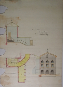
Plan - MARKS COLLECTION: PLAN FOR NEW ENTRANCE VESTIBULE TO FORTUNA VILLA FOR GEO. LANSELL ESQ
Fortuna Villa was owned from 1855 to 1871 by Christopher and Theodore Ballerstedt, Australia’s first mining magnates. In 1871 it was purchased by George Lansell (The Quartz King) being one of Australia’s most successful and adventurous nineteenth century gold mine owners and speculators. Lansell made numerous alterations extensions to the building and remained in the Lansell family until 1935plan for new entrance vestibule to Fortuna Villa for George Lansell Esq. coloured plan detailing new entrance vestibule and open recess across the verandah, and entry steps RHS of page damaged/ tornfortuna villa, geo.lansell esq., building plan, c & t ballerstedt -
 Bendigo Historical Society Inc.
Plan - MARKS COLLECTION: PLAN FOR TWO STOREY OPEN VERANDAH ADDITION TO FRONT AND SIDE ELEVATIONS TO FOTUNA VILLA FOR GEO. LANSELL ESQ
Fortuna Villa was owned from 1855 to 1871 by Christopher and Theodore Ballerstedt, Australia’s first mining magnates. In 1871 it was purchased by George Lansell (The Quartz King) being one of Australia’s most successful and adventurous nineteenth century gold mine owners and speculators. Lansell made numerous alterations extensions to the building and remained in the Lansell family until 1935Plan shows front and side elevations only for the addition of a two storey lacework verandah to Fortuna Villa for George Lansell Esq. Black ink hand drawn plan for verandah elevations Plan badly damaged with water damage, flocking, tears and a hole in the paper plan. Hand drawn additions to the plan with pencilbendigo fortuna villa, george lansell -
 Bendigo Historical Society Inc.
Document - MCCOLL, RANKIN AND STANISTREET COLLECTION: NELL GWYNNE MINES LETTER
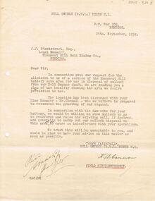
Letter to J.J. Stanistreet, Legal Manager, Monument Hill Gold Mining Co., Bendigo from Nell Gwynne Mines N.L., dated 26th September 1934. Letter in connection with our request for the allotment to us of a section of the Monument Hill battery site area for use in disposal of mullock from our Nell Gwynne shaft. Mentions raising wall of existing wall of dam. Plan of the locality attached. See 2205.846.bendigo, business, nell gwynne mines n.l. -
 Bendigo Historical Society Inc.
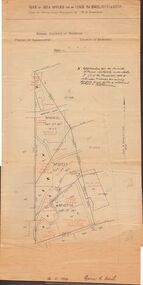
Map - MCCOLL, RANKIN AND STANISTREET COLLECTION: MAP LEASE NO 10423
Buff coloured map. On top of map 'plan of area applied for on lease no. 10423, under the mining leases regulations, by John G. Stanfield, mining district of Bendigo. Map shows lease coloured in red, see record 2205.821b for letter pertaining to map. Street on map: Rowan St., Shamrock St., Mackenzie Street, Old High St., High Street, Ophir Street, Booth Street.bendigo, business, mccoll, rankin & stanistreet -
 Bendigo Historical Society Inc.
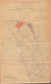
Document - MCCOLL, RANKIN AND STANISTREET COLLECTION: PLAN OF AREA LEASE 10425, 10733 AND 10734, 1934
Plan of area applied for on lease No 10425, 10733 and 10734. Applied for by Mr. R.A. Rankin. Plan shows Marong Road, state school site ; leases held by H.E. Kronk, Francis Gramann; T. Wearne; C.E. Foggitt; A. Pitcher, Crown land and Aur. licences also marked. Lease numbers marked on plan. Map signed on bottom by Garnet G. Birch on 26.11.1934. On top Rh side in black pen " applications for the Minister of Mines Authority under section 5 (1) of the Mines Act 1928 to enter upon and occupy for mining purposes such portion of allotments lodged on 19/2/35'gold, mining, lease, mining, leases, kronk, garnet g. birch -
 Bendigo Historical Society Inc.
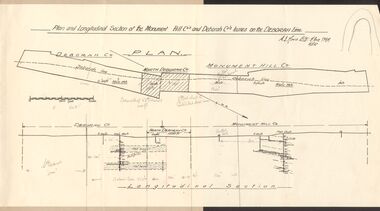
Document - MCCOLL, RANKIN AND STANISTREET COLLECTION: MONUMENT HILL CO., DEBORAH CO. LEASE ON DEBORAH LINE
... BUSINESS Mining mccoll rankin & stanistreet Plan ...Plan of Monument Hill Co., and Deborah Co. leases on the Deborah line. Black line drawing, showing longitudinal section. 'Deborah shaft to Nth Deborah 1100 ft ' noted in pencil . 'Nth Deborah shaft to Central Deb shaft 2000ft' in pencil. Other pencil notation on map re distance of leases. Map is attached to back page of booklet, rest of information missing.business, mining, mccoll rankin & stanistreet