Showing 444 items
matching mining site
-
 Stawell Historical Society Inc
Map, Stawell Gold Mine, Milling Area Site Arrangement 2002, 12/6/2002
Plus Bench Mark Levels Stawell Gold Mines Victoria Scale 1 : 20000mining, gold -
 National Wool Museum
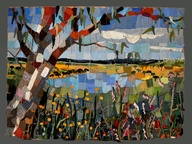
Textile - Community Textile Tapestry, Lisa Kendal et al, WARM, 2016
WARM was a community textile art project that saw over 250 knitters come together to create a beautiful collage tapestry. Made entirely from wool, the artwork contains more than 1000 individual hand knitted sections. The project takes aim at global warming, it highlights both the causes and solutions for us to create a sustainable and safe climate for future generations. Lisa Kendal, the co-creator of the project, said “One of the problems in the world is that we have forgotten how to warm ourselves with wool. We have become too dependent on fossil fuels (for heating)”. This is the key idea surrounding the project. WARM began as two large scale images created by Lars Stenberg. The first image is a landscape scarred by coal mining. The second image is the same landscape only many decades later. Regeneration and regrowth have taken over the landscape and hidden the past coal mine completely. In its place is a beautiful landscape including trees, native flowers, a lake, lots of greenery and wind turbines. From March to the end of August in 2016, knitters worked hard to create the over one thousand pieces that came together to form the final tapestry. The pieces were all designed by Fibre Artist Georgie Nicolson of Tikki Knitting Designs, who converted the second image of the healed landscape into patterns for the 250 plus knitters to follow. These patterns included unusual designs such as gum leaves, trees, native flowers and even the wind turbines. During several days of installation, the knitted pieces were stitched together by Lars Stenberg over a picture of the first image of the operational coal mine. They worked to create the second image of the renewed landscape; like an enormous collage. The WARM project was donated to the National Wool Museum in 2021. It was a much-loved hanging within the Ballarat Hospital for many years before coming to the museum. More information about the project can be found on the following website. http://www.seam.org.au/warm The tapestry is made from 1000+ hand knitted sections stitched together to make an image. In the foreground of this image is a large gum tree that stretches from the bottom left to the top right corner. The trunk of this tree follows the left edge of the tapestry, with foliage from the gum tree spanning its top border. The bottom third of the tapestry is predominantly green grass with yellow, pink and red flowers providing sporadic colour. The middle third encompasses a lake, with orange colours surrounding the banks of the water as opposed to the green grasses of the bottom third. To the right of the lake are wind turbines. The top third of the tapestry is blue sky with white clouds. It also contains the previously described gum tree leaves. Each piece of the tapestry is 100% wool and was hand knitted and stitched together. The Tapestry is accompanied by an oil painting on canvas. It is a painting that matches the tapestry and served as a template for the final tapestry. Finally, the tapestry is accompanied by another pointing on wood board. This final panting is of a coal mine. This is the setting before regeneration and regrowth have reclaimed this site, which is the theme captured in the final tapestry. In the foreground of the coal mine painting is the same gum tree described in the tapestry; however, it is grey and sickle with only 4 leaves visible at the top border, compared to the numerous leaves in the tapestry. Also in the foreground is a broken barb wire fence adding to the unwelcoming nature of the site. The colour scheme of this image is of dark greys and browns. A coal fired power plant can be seen in the final third of the image with four chimneys emitting plumes of smoke into the sky. In front of this power plant is the spiral shape of a coal mine, burrowing deep into the earth’s crust. Inside of the coal mine 3 yellow trucks are seen mining and transporting coal to the top of the mine.warm, community textile tapestry, knitting, community artwork, global warming -
Whitehorse Historical Society Inc.
Article, Old gold mine site is found
The exact site of the old goldmine in the Lake Road - Halley Street area of Blackburn was located and identified by local history investigators.The exact site of the old goldmine in the Lake Road - Halley Street area of Blackburn was located and identified by local history investigators. Ray Champion said it was on a property he owned, his father Isaac Champion had filled in the mine in 1904. The mine had successfully operated up until about 1880.The exact site of the old goldmine in the Lake Road - Halley Street area of Blackburn was located and identified by local history investigators. mines and mining, champion, isaac, ray, halley street, blackburn, lake road, dickens street, goldmining -
 Whitehorse Historical Society Inc.
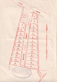
Document, Dickens Street, Blackburn
Auction of housing development in Dickens Street, Blackburn, comprising 25 sites, leading off Lake Road. Agent Frank Fisher & Co.dickens street, blackburn, frank fisher co., lake road -
 Rutherglen Historical Society
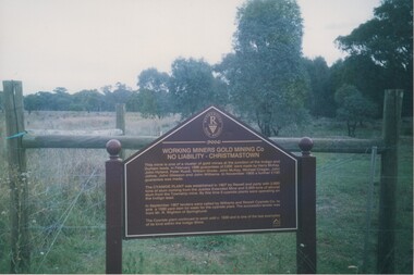
Image, 2004
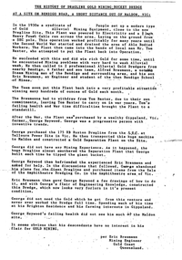
Colour photograph of a story board marking former site of a gold processing cyanide plant at Christmastown. Photo is mounted on an album page.storyboards, working miners gold mining co, gold mining, cyanide plant -
 Ballarat Heritage Services
Photograph - Photograph - Colour, Clare Gervasoni, Nimon's Bridge, 1999, 04/10/1999
Nimons Bridge was built in 1890, as part of the then Ballarat-Linton railway. The bridge is 17 spans with tall timber piers of four driven piles each, with triple sets of diagonal cross-bracing and walers and a single row of longitudinal horizontal bracing between piers. The spans are of a uniform twenty feet (6.1 metres), originally supported by four 21-inch x 9-inch (535 mm x 230 mm) Kauri timber beams per span, following the standard V.R. design of the period. When the superstructure was rebuilt after the 1953 fire, the timber beams were replaced with two 24-inch (610mm) deep rolled-steel-joists on each span. These are marked 'Lancashire Steel Co., Scotland' and are believed to have been second-hand. The deck of transverse-timber planks is 103.6 metres in length. Overall the bridge has an impressive appearance with its exceptionally tall triple-cross-braced piers creating a 'three-tiered' effect, with the deck 19.2 metres above the Woady Yaloak River. The Ballarat-Skipton line closed in 1985. Nimons Bridge has been recently restored, as part of the Ballarat-Skipton Rail Trail. How is it significant? Nimons Bridge is significant for technical, historic and aesthetic reasons at a State level. Why is it significant? Nimons Bridge is technically significant as Victoria's fourth-tallest timber trestle bridge when built, and as the third-tallest surviving example. It is also the second-largest composite bridge combining traditional timber piers with RSJ spans and a timber deck and falls within a select group of fewer than ten timber railway bridges with horizontal longitudinal bracing between the piers and three sets of double cross-bracing on its tallest piers, creating a visually striking 'three tiered' effect that enhances its viaduct form. Nimons Bridge is historically significant as having served initially the mining community at Linton, then the Western District agricultural area and in later years a kaolin quarry at Pittong. Nimons Bridge is historically significant as a representative of the 'light' branch line methodology that stimulated the explosion of railway construction in Victoria during the 1880s, and provides an interesting contrast with the more solid and vastly more expensive railway viaducts built in similar terrain on Victorian main lines, at Moorabool and Taradale, in the late 1850s. Approached by a deep cutting and high embankment at either end, the bridge represents a very cost-effective late 19th century engineering solution to the characteristic physiography of western Victoria with flat basalt plains intersected by deep wide valleys occasionally subject to severe flooding. Nimons Bridge is aesthetically significant for its visually impressive viaduct form, crossing a deep and steep-sided valley that is part of a rich cultural landscape. Within close proximity of the bridge are mullock dumps, tailings, shaft sites and other relics of the deep-lead alluvial mining era. The bridge is the most visually spectacular timber-trestle rail bridge in Western Victoria and is among the most spectacular timber-trestle rail bridges surviving anywhere in Victoria. It is part of the Ballarat-Skipton Rail Trail. Classified by the National Trust :02/10/2000 (http://vhd.heritagecouncil.vic.gov.au/places/67986)Colour photograph of a log bridge known as Nimon's Bridge.ballarat-linton, nimons bridge, nimon's bridge, log bridge, viaduct, timber-trestle rail bridge -
 Ballarat Heritage Services
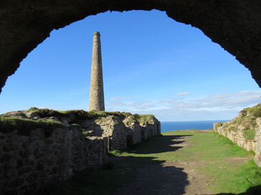
Photograph - Colour, Chimney, St Just, Cornwall
Many Cornish from St Just came to the Victorian goldfields. They were excellent miners. St Just is a World Heritage Site. st just, cornwall, cornish, mining, industrial heritage -
 Ballarat Heritage Services
Photograph - Photograph - Colour, Corner of Vickers Street and Albert Street, Sebastopol, 2020, 07/04/2020
The South Star Mine commenced operations in the 1880s and worke the quartz laods after the great floods of 1875 forced the closure of most alluvial mines. The South Star Mine sunk its first shaft in 1886, but broke into old alluvial workings and had to be abandoned because of flooding. The second shaft commenced in 1887, and was the deepest eer sunk in the Ballarat district, reaching 956 metres. 180 men worked three shifts each day.Colour photograph of the site of the South Star Mine in Sebastopol. sebastopol, albert street, south star mine, mining -
 Ballarat Heritage Services
Photograph, Mullock Heap In Victoria Park, Ballarat, 2014, 04/11/2014
The large mullock heap, marks the site of a former quartz mine, and is one of the few visible signs of the former presence of extensive gold mining activities in this area of Ballarat. Originally known as Park Mine, and now known as Mount Holled Smith, the mine associated with this mullock heap puddled 750 tons of washdirt each day. The mine closed down in 1874, at which time 94,699 ounces of gold had been removed from the ground. Colour photograph of a mullock heap in Ballarat's Victoria Park.mullock heap, ballarat gardens, victoria park, park mine -
 Lions Club of Maldon Inc.
Document, The History of Dragline Gold Mining Bucket Dredge at a site on Bendigo Road
-
Unions Ballarat
AMWU/CFMEU (Waubra Windfarm) Windcheater, circa 2010-2018
The Waubra Wind Farm is located north-west of Ballarat. It is one of the largest wind farms in Victoria. The CFMEU and AMWU have coverage of the site.Local economy. Sustainability and environmental management. Union membership.Polyester and cotton windcheater; black and red; yellow and white embroidery.1. Waubra Windfarm - 100% Union [front] 2. Line 1: CFMEU + Southern Cross Flag emblem + AMWU Line 2 & 3: Dare to Struggle dare to win [front] 3. No ticket, no start [back] 4. AMWU [left sleeve] CFMEU [right sleeve] 5. Tags showing the maker's details (FCW Fashion), size, cleaning instructions, fabric type [inside collar]. btlc, ballarat trades hall, ballarat trades and labour council, cfmeu, amwu, australian manufacturing workers' union, construction forestry and mining employees union, wind farms, ecology, sustainability, union merchandise -
 Ballarat Heritage Services
Photograph - Colour, Clare Gervasoni, Port Phillip Mine, Clunes, 2006, 07/12/2006
Remains of an arch structure on the site of the Port Phillip Mine at Clunes, Victoria.port phillip mine, clunes, mining -
 Old Colonists' Association of Ballarat Inc.
Photograph - Photograph - Colour, Ballarat Old Colonists' Association Homes, Charles Anderson Grove, Ballarat
HISTORY OF THE BALLARAT OLD COLONISTS' ASSOCIATION HOMES AT CHARLES ANDERSON GROVE, LAKE GARDENS One of the original objectives of the Association was “to provide the shelter of a house for those Pioneers of the Goldfields whom the reverses of fortune have deprived of the means of procuring the comforts of life in their declining years.” While the first home at Charles Anderson Grove was built in 1925 the Association had previously provided relief for needy pioneers from the time it was formed in 1883. Relief included monthly monetary payments, loads of firewood, medical assistance and distribution of Christmas boxes of groceries to deserving pensioners and in some cases payment of burial costs. Records indicate that in September 1922 three of the pensioners being assisted by the Association were accepted as residents in the newly erected Hassell Homes in Gillies Street (now demolished-opposite the High School). The first site for an Asylum for Indigent Members of the Old Colonists' Association was temporarily reserved from sale in October 1891. The site was approximately 28 acres in area in Mt Clear nearly opposite Midvale Shopping Centre in Main Road. The site was heavily timbered and when cleared over 260 tons of wood was sold to the Woah Hawp Gold Mining Company. A set of gates were erected but no homes built, although a plan for this reserve was drawn which showed twenty buildings ranging from one to four unit per building. The reserve was revoked in November 1909. The second site temporarily reserved in November 1909 as an Asylum was in Alfredton and consisted of some 7 acres and was adjacent to land reserved for an Abattoirs for the Ballarat Council. The reserve was revoked in February 1912 as it was deemed more appropriate to be added to the Abattoir site. Council suggested four (4) other sites in exchange for this land and they were inspected by the President, Vice President and Secretary on 22 December 1912. The first site inspected was land on the west side of Creswick Road opposite the brick kilns (now occupied by the showgrounds and oval). The land was described as being good quality, well fenced, no trees, good drainage and ample acreage but some distance from trams. The second site was Perry Park which was described as being good land, well fenced, having frontage to Gillies Street, good drainage and about 26 acres (but subsequently reduced to 10 acres). It was closely planted with Pinus Insignias and Wattle and had easy access from the Botanic Gardens tram. The third site was the North West portion of Victoria Park (corner of Sturt and Gillies Street) and was described as good land, well fenced and drained and well located. The fourth site was the South West corner of Victoria Park and known as Pound Paddock (corner of Winter Street and Gillies Street). It was considered to be low lying and too close to the Abattoir, and was also a considerable distance from trams. While the third site was recommended as the most suitable for the erection of homes it was considered unwise from the point of view as citizens to reduce the acreage of the park and therefore it was recommended that the Perry Park site be asked for as the most acceptable to the Association for the building of homes. The site was eventually temporarily reserved for an Asylum for Indigent Members of the Association in April 1914 with the gates from Mt Clear having been removed to the site a year earlier and eventually erected in 1917 for £12.10.0. In the same year the first 290 pine trees were advertised for removal in July and sold for £16. A sign indicating that the site was reserved for the erection of cottages was erected in September 1917. Stripping of the wattle bark (for tanning) and the cutting of the wood occurred in November 1918 with the land then being leased until it was required for the construction of the first homes in 1924. While the site was the third to be reserved it was the only one which was used for its intended purpose. It was named as Charles Anderson Grove in honour of Charles Anderson who joined the Association in 1918 and was President of the Association from 1942 to 1944. A number of cottages in the Ballarat Old Colonists' Association Retirement Village of Gillies Street, Ballarat.charles anderson grove, old colonists' club, ballarat, old colonists' association, old colonists' homes, retirement village -
 Old Colonists' Association of Ballarat Inc.
Photograph - Image, The History of Charles Anderson and Charles Anderson Grove, Ballarat
Information relating to Charles Anderson and Charles Anderson Grove, Lake Gardens, Ballarat. The Old Colonists' Association Ballarat Inc. is a not for profit charitable organisation providing accommodation for elderly people. It manages a 27 Home retirement village at Charles Anderson Grove, Ballarat. Accommodation is offered at significantly below market rates. It has been providing low cost accommodation to the elderly since the 1920s. The Association Council overseas the running of this facility on a voluntary basis. HISTORY OF THE BALLARAT OLD COLONISTS' ASSOCIATION HOMES AT CHARLES ANDERSON GROVE, LAKE GARDENS One of the original objectives of the Association was “to provide the shelter of a house for those Pioneers of the Goldfields whom the reverses of fortune have deprived of the means of procuring the comforts of life in their declining years.” While the first home at Charles Anderson Grove was built in 1925 the Association had previously provided relief for needy pioneers from the time it was formed in 1883. Relief included monthly monetary payments, loads of firewood, medical assistance and distribution of Christmas boxes of groceries to deserving pensioners and in some cases payment of burial costs. Records indicate that in September 1922 three of the pensioners being assisted by the Association were accepted as residents in the newly erected Hassell Homes in Gillies Street (now demolished-opposite the High School). The first site for an Asylum for Indigent Members of the Old Colonists' Association was temporarily reserved from sale in October 1891. The site was approximately 28 acres in area in Mt Clear nearly opposite Midvale Shopping Centre in Main Road. The site was heavily timbered and when cleared over 260 tons of wood was sold to the Woah Hawp Gold Mining Company. A set of gates were erected but no homes built, although a plan for this reserve was drawn which showed twenty buildings ranging from one to four unit per building. The reserve was revoked in November 1909. The second site temporarily reserved in November 1909 as an Asylum was in Alfredton and consisted of some 7 acres and was adjacent to land reserved for an Abattoirs for the Ballarat Council. The reserve was revoked in February 1912 as it was deemed more appropriate to be added to the Abattoir site. Council suggested four (4) other sites in exchange for this land and they were inspected by the President, Vice President and Secretary on 22 December 1912. The first site inspected was land on the west side of Creswick Road opposite the brick kilns (now occupied by the showgrounds and oval). The land was described as being good quality, well fenced, no trees, good drainage and ample acreage but some distance from trams. The second site was Perry Park which was described as being good land, well fenced, having frontage to Gillies Street, good drainage and about 26 acres (but subsequently reduced to 10 acres). It was closely planted with Pinus Insignias and Wattle and had easy access from the Botanic Gardens tram. The third site was the North West portion of Victoria Park (corner of Sturt and Gillies Street) and was described as good land, well fenced and drained and well located. The fourth site was the South West corner of Victoria Park and known as Pound Paddock (corner of Winter Street and Gillies Street). It was considered to be low lying and too close to the Abattoir, and was also a considerable distance from trams. While the third site was recommended as the most suitable for the erection of homes it was considered unwise from the point of view as citizens to reduce the acreage of the park and therefore it was recommended that the Perry Park site be asked for as the most acceptable to the Association for the building of homes. The site was eventually temporarily reserved for an Asylum for Indigent Members of the Association in April 1914 with the gates from Mt Clear having been removed to the site a year earlier and eventually erected in 1917 for £12.10.0. In the same year the first 290 pine trees were advertised for removal in July and sold for £16. A sign indicating that the site was reserved for the erection of cottages was erected in September 1917. Stripping of the wattle bark (for tanning) and the cutting of the wood occurred in November 1918 with the land then being leased until it was required for the construction of the first homes in 1924. While the site was the third to be reserved it was the only one which was used for its intended purpose. It was named as Charles Anderson Grove in honour of Charles Anderson who joined the Association in 1918 and was President of the Association from 1942 to 1944. CHARLES HENRY GRATTAN ANDERSON C.H.G. Anderson (Electoral Returning Officer) was elected to membership of the Old Colonists' Association, Ballarat, in October 1918. He was elected to the Association Committee in 1926, and appointed Treasurer of the Association on the resignation of F. Ellis until the end of the financial year in 1933. In 1936 Charles Anderson indicated he would not be available for the President's Chair and that he would retire from the Committee owing to pressure of work. C.H.G. Anderson was welcomed as a new member of the Association in 1938, and served as President of the Old Colonists' Association from 1942-1944. Midway through 1949 Charles Anderson was appointed Members Secretary and Manager of the Ballarat Old Colonists' Club at £5.0.0 per week and 10/- for entertainment, to commence work prior to 01 August 1949. He was to do 30 hours per week and be present on Friday and generally on Saturday nights. In 1957 a minute of sympathy was extended to Club Manager Charles Anderson on the loss of his son. In 1958 a bonus of £20.0.0 was paid to Charles Anderson in recognition of his service in assisting the Secretary/Manager taking over under difficult conditions. In March 1964 the Shire of Ballarat would not permit a private road to be named Anderson Grove as Anderson Street already existed in Ballarat but Charles Anderson Grove was deemed acceptable. A recommendation of the Committee was put to the AGM in 1967 that Charles Anderson be made a Life Member. In 1969 an Association meeting observed a minutes silence in memory of Chas Anderson. Charles Anderson was also a Committee member of Ballarat Mechanics' Institute from February 1940 to February 1970. He was President in 1948. Black and white photographic portrait of Charles Anderson.charles anderson, charles anderson grove, ballarat old colonists' club, old colonists' association, ballarat, ballarat mechanics' institute, hassell homes, woah hawp gold mining company, firewood, retirement village -
 Old Colonists' Association of Ballarat Inc.
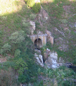
Print - Image, The Mining Registrar's Office, c1887
... The Old Colonists' Hall is built on the site of the former...' Hall is built on the site of the former Mining Registrar's ...The Old Colonists' Hall is built on the site of the former Mining Registrar's Office, and the bluestone was reused in the foundations. This image was reproduced in the 1887 edition of W.B. Withers 'History of Ballarat'.Drawn image of the Ballarat Mining Redistrar's Office in Lydiard Street.ballarat mining registrar's office, old colonists' hall, bluestone -
 Bendigo Historical Society Inc.
Slide - DIGGERS & MINING: THE DIGGINGS - THE DIGGERS
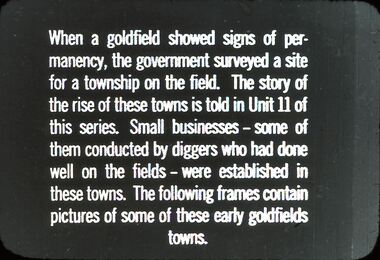
Diggers & Mining: The Digging - The Diggers. Slide; When a Gold field shows signs of permanency, the Government surveyed a site for a township on the field. The story of the rise of these towns is told in Unit II of this series. Smalll businesses - some of them conducted by diggers who had done well on the fields - were established in these towns. The following frames contain pictures of some of these early goldfields towns. Black and white side. Markings: 40 994.LIF:6. Used as a teaching aid.hanimounteducation, tertiary, goldfields -
 Bendigo Historical Society Inc.
Slide - DIGGERS & MINING: THE DIGGINGS - THE DIGGERS
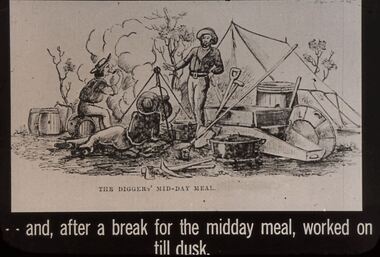
Diggers & Mining: The Digging - The Diggers. Slide depicts miners relaxing back at the camp site. Puddling machine, gold pan, shovel and other items needed by miners, there is also a tent. Not many trees. Markings: 31 994.LIF:6. Used as a teaching aid.Hanimounteducation, tertiary, goldfields -
 Bendigo Historical Society Inc.
Document - HERITAGE REPORT: FORMER POLICE STATION AND QUARTERS: CALIFORNIA GULLY
... Council Victorian Police Force D Bannear Historic Mining sites ...Seventeen page Heritage Place Report on the Former California Gully Police Station at 15 Thorpe Street, California Gully. It is the former police station and quarters, former timber stables and timber cottage residence demolished and horse paddock on separate title. Report includes a Statement of Significance, Place History (History of the Area), Policing California Gully Goldfields, History of the Buildings, Chronology of Ownership, Rate Books 1858, - 1867 - 1868, 1895 Borough of Eaglehawk Rates, 1922 Voters Roll, 1952 & 1962 Sands & McDougall Directory Thorpe St California Gully, Comparable Examples, Secondary Sources, Description Conservation Policy Guidelines (Specific), Physical Conditions, Physical Description 1, Map of Early Photo Location, Bendigo Parish Plan circa 1870, Certificate of Title 1950 & 1960. Pge 14 has plans, maps and an aerial photo of 15 Thorpe Street. Page 15 has an aerial photo of 15 Thorpe Street, California Gully with Allotment Size. Page 16 & 17 has photos.heritage, heritage report - former police station and quarters - california gully, city of greater bendigo, wilson & ass, butler, amanda jean, johnson reef shafts no 1 & 2, rose of denmark, princess dagmar, bendigo amalgamated goldfields company, captain frederick standish, royal irish constabulary, e thorpe, campbell, taylor, watson, brown, hosken, mckowne, mcqualter, parker, hicks, eaglehawk municipal council, victorian police force, d bannear, historic mining sites in the sandhurst eaglehawk and raywood mining divisions, department of conservation and natural resources, joshua thorpe, thorpe & co, johnson & co, william thorn, michael thomas, james murdock, edward c brown, francis youlden, gold escort, water police, mounted police, city police (melbourne), geelong police, gold fields police, rural bench constabulary, the people's force, robert haldane, n wild, streets of the borough of eaglehawk, police registration act, william henry mitchell, camp hotel, j o c nieman, j m catarach, g w hosken, margaret hosken nee mckown, majorie alice mcqualter, kellie anne mcqualter, adam joseph doolan, mr hicks, sands & mcdougall, hill george, meeking howard, mcewan frank a, jinks stanley, mccaig mrs eleanor, gordon john l, mcqualter mrs adeline, maher william l, raynor robert, flack john p, whitehead miss a, sang george t, linddsay john p, dyer henry, jackman george a, tibbetts mrs s a, hosken mrs margaret winifred nee mckowne, chaplin frank w, wilson c e, wright george, miller g a, sheyhill basil hugh, marshall r, miles j h, parker w b, barkla w g, nicholls les, cartledge clifford william, cole charles basil, farmers citizens trustees co, bev hanson -
 Bendigo Historical Society Inc.
Slide - DIGGERS & MINING. THE CHINESE ON THE GOLD FIELDS, c1877
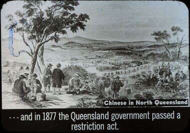
Diggers & Mining. The Chinese on the Gold Fields. Slide:Chinese in North Queensland . . . . And in 1877 the Queensland government passed a restriction act. Chinese on the long journey to their destination, a camp site on the right, on the left they take shelter under a tree. Markings: 5, blue ink smuge on left of slide in tree. Used as a teaching aid.hanimounteducation, tertiary, goldfields -
 Bendigo Historical Society Inc.
Slide - DIGGERS & MINING. STORES AT THE DIGGINGS, c1855
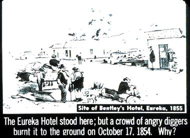
Diggers & Mining. Stores at the diggings. STG Site of Bentley's Hotel, Eureka, 1855. The Eureka Hotel stood here; but a crowd or angry diggers burnt it to the ground on October 17, 1854. Why? Slide shows dog, ox and diggers. Buildings in the background. Markings: 45 994.LIF. 5. Used as a teaching aid.hanimounteducation, tertiary, goldfields -
 Bendigo Historical Society Inc.
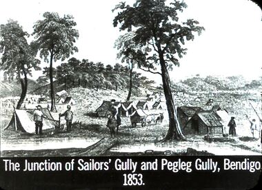
Slide - DIGGERS & MINING: THE DIGGINGS - THE DIGGERS
Diggers & Mining: The Digging - The Diggers. Slide depicts: The Junction of Sailors' Gully, Bendigo 1853. Many tents on the site, some miners, a few trees are left on hill tops. Markings: 21 994.LIF:6. Used as a teaching aid.hanimounteducation, tertiary, goldfields -
 Bendigo Historical Society Inc.
Book - CENTRAL DEBORAH MINE CORRESPONDENCE RE PLANT DEVELOPMENT PART 2
Black folder containing photocopied documents pertaining to the setting up and running of the Central Deborah Mine, Bendigo. 1939 - 1948. Original copies held in McColl,Rankin & Stanistreet Collection. Application for Permit. Ministry of Post War Reconstruction. War Organisation of Industry. Quotes, Tenders. Hume & Iser. T.J Jorgensen. Electricity Supply Department. Saunders & Ross. District Telephone Office. R Toma. Stock Exchange. Building Site Plan. Abbott Supply Co. F.W. Milne & Son. The Golden City Agricultural Implements. Department of Labour and National Service.Miller & Co. Thompson Engineering and Pipe Co. Gold Boring and Prospecting. Costs. J.l. Howard. A.J. William Electrical Instruments.bendigo, mining, central deborah gold mine -
 Bendigo Historical Society Inc.
Slide - DIGGERS & MINING: THE DIGGINGS - THE DIGGERS
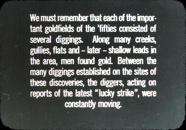
Diggers & Mining: The Digging - The Diggers. Slide reads: We must remember that each of the important goldfields on the 'fifties' consisted of several diggings. Along many creeks, gullies, flats and - later- shallow leads in the area, men found gold. Between the many diggings established on the sites of these discoveries, the diggers, acting on reports of the latest ''lucky strike'', were constantly moving. Markings: 8 994.LIF:6. Used as a teaching aid.hanimounteducation, tertiary, goldfields -
Bendigo Historical Society Inc.
Booklet - Victoria Hill
Victoria Hill, accessed from Marong Road, was one of the richest areas on the Bendigo goldfields and was the beginning of reef mining as opposed to alluvial mining. Between 1853 and 1861 there were 16 claims registered on Victoria Hill. Between 1908 and 1910 it was the site of the world's deepest shaft (1365-1406 meters)Today it provides interpretive walks that include sites such as an open-cut mine (1850's), poppet head, quartz crushing battery (1930's) and the foundations of George Lancell's 180 mine. It is registered as a site of historical significance.Clear plastic cover spiral bound booklet of 25 pages. 'Victoria Hill'. A historical background of Victoria Hill and the surrounding area. A colour photo of a poppet head on front. Original story written by Albert Richardson in 1971. This is a revised edition by Philip Wilkin in 2012. Illustrated with colour and B&W photos. Pages 13 to 25 have been inadvertently inserted upside down. A single page A4 leaflet 'Victoria Hill Self Guided Tour' has been put inside after page 1Handwritten in ink on front page 'Donated to Specimen Cottage'victoria hill, gold mine -
 Bendigo Historical Society Inc.
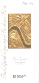
Card - Kangaroo Flat Gold Mine Collection: The Official Opening of Bendigo's Mine, Bendigo Mining NL, October 2006
Trifold invitation. On front cover is gold coloured image of rock strata. Written underneath: 'The Objective, to bring gold back to Bendigo'. On bottom of front page 'Bendigo Mining' with poppet head logo. Inside on first page: Your invitation- Peter McCarthy, Chairman Bendigo Mining Limited and Doug Buerger, Managing Director and Chief Executive Officer, request the pleasure of your company for the official opening of Bendigo's Mine at the kangaroo Flat site by Hon Steve Bracks, Premier of Victoria, on Friday 20 October, 2006. Colour photos of a gold pour, underground mining and a miner, on other pages of invitation. environment, kangaroo flat, goldmining, , environmental impact, exploration, mining, bendigo mining, doug buerger, peter mccarthy -
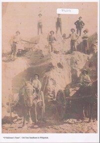 Bendigo Historical Society Inc.
Photograph - Sand mining at the Whipstick
Old Tom mine included quartz mining and open cut mining. Today the remains of the battery site, cyanide plant, hydrolic sluicing and a 1930's puddler can be seen. It was operating in August 1874 and was taken over in 1897 by an English syndicate, J. R. Syndicate. By 1899 the mine had reached 500 feet in depth . The mine closed c. 1901.8529 Sand mining at Old Tom mine the Whipstick, Eaglehawk. O'Halloran's team of nine men and two horses and carts. Two men with horse and carts; and seven men on top of the sand deposit. A4 copy of 1513 Box 25sand mining, whipstick, old tom mine -
 Bendigo Historical Society Inc.
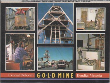
Souvenir - Photographs: Central Deborah Mine
The Central Deborah Mine closed it's mining operations in 1954. The complete nature of the site encouraged the Bendigo City Council to purchase the site in 1970 in order that it be preserved. In 1971 the Bendigo Trust was formed and under its auspices the surface was opened to tourists in 1971' Extensive work enabled Level 2, underground to be opened to the public. This was followed in 1998 by Underground Level 3 Adventure tours. In 2011 visitors were able to tour as far down as Level 9, 228 meters below ground making it the deepest underground mine tour.Concertina souvenir six photographs of mining at Central Deborah Gold Mine Bendigo Victoria. Could be broken up to send as six separate postcardspostcards, central deborah mine -
 Bendigo Historical Society Inc.
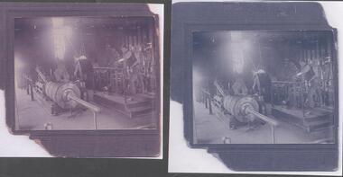
Photograph - Monument Hill Gold Mine Engine Room, 1930's, exact date unknown
The Monument Hill Gold Mine was at the corner of Old Violet Street and Olive Street. It operated until 1947. The shaft was capped, the poppet legs and mullock removed. A house now occupies the site. The Monument Hill Gold mine depth was over 1200 ft. The donor of the photograph is the grandson of Albert Dunstan, and he recalls that 'the mine was fully operational in the 1940's and I was often able to see my Grandfather at work and watched as men stepped into cages to be lowered to their awful occupation'. Donor's great, great grandfather was John Perry Dunstan, a well respected mine manager on the Bendigo goldfield.Two black and white copies of original photograph. Image shows Albert Ernest Dunstan working in the engine room of the Monument Hill Gold Mine, Bendigo. Albert is at the controls of the engine, lowering and raising the mining cage; he is leaning on the support railing around the elevated platform he is standing on. Letter accompanying images describes the donor's family connection to John Perry Dunstan and Albert Ernest Dunstan, he writes that ' the mine was fully operational in the 1940's and I was often able to see my Grandfather at work and watched as men stepped into cages to be lowered to their awful occupation. I was very surprised that today there is a home sitting above what was once a very deep mine'.monument hill gold mine, albert dunstan, old violet street, olive street, engine room, mining cage -
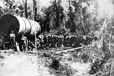 Stawell Historical Society Inc
Photograph, Large Boiler being transported by Horses from the Magdala Mine Site in Stawell to the Heatherlie Quarry
Large Boiler being transported by Horses probably in location of Fyans Creek. Boiler being transported from the Magdala Mine Site in Stawell to the Heatherlie Quarry to replace unserviceable Boiler.stawell industry mining -
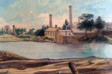 Stawell Historical Society Inc
Photograph, Magdala cum Moonlight Mine c1890 -- Painting
Black and White photo of Magdala cum Moonlight Mine plus colour painting of simular scene.Colour painting of mine site with dam in foregroundstawell gold mining