Showing 25249 items
matching north
-
 Kew Historical Society Inc
Archive (Sub-series) - Subject File, Kew Historical Society, North East Link, 2019
Various partiesReference, Research, InformationSecondary Values (KHS Imposed Order)Subject file containing documents relating to the development and impact of of North East link in Melbourne.north-east link, transport infrastucure - kew (vic), roads - kew (vic), streets - kew (vic), freeways - kew (vic)north-east link, transport infrastucure - kew (vic), roads - kew (vic), streets - kew (vic), freeways - kew (vic) -
 Brimbank City Council Art Collection
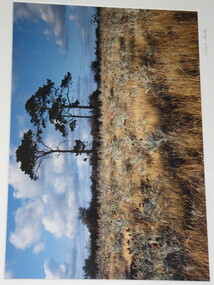
Photograph, Robert Pointon, South Sunshine looking North, 1989
Local SceneRobert Pointon. South Sunshine looking North. Colour photograph, 34 x 49cm -
 Tarnagulla History Archive
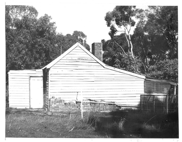
Photograph of a cottage, north end of Commercial Road, Tarnagulla, Cottage, north end of Commercial Road, Tarnagulla, Late 1960s
Murray Comrie Collection. Monochrome photograph depicting a view of a cottage located at the north end of Commercial Road, Tarnagulla. tarnagulla, houses, commercial road -
 Whitehorse Historical Society Inc.
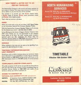
Pamphlet - Bus Timetable, National Bus Company Pty LTD, North Nunawading Bus Services, 10/10/1994
A National Bus Line map and timetable for North Nunawading in 1994 (Routes 270 and 271)A National Bus Line map and timetable for North Nunawading in 1994 (Routes 270 and 271)non-fictionA National Bus Line map and timetable for North Nunawading in 1994 (Routes 270 and 271) -
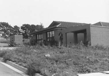
 Ringwood and District Historical Society
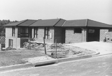
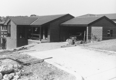
Photograph, No.5 Menzies Drive, North Ringwood under construction 1982
Written on back of photograph, "21/4/82. No.5 Menzies Drive, North Ringwood". -
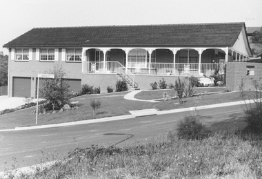
 Ringwood and District Historical Society
Photograph, No.3 Menzies Drive, North Ringwood 1982
Written on back of photograph, "21/4/82. No.3 Menzies Drive, North Ringwood" -
 Ringwood and District Historical Society
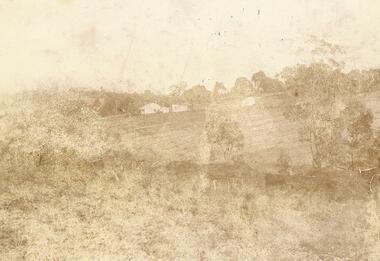
Photograph, Quambee, North Ringwood, 1912 - viewed from Coombes' property
Written on back of photograph, "Quambee, North Ringwood, 1912 - viewed from Coombes' property." -
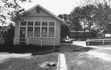
 Ringwood and District Historical Society
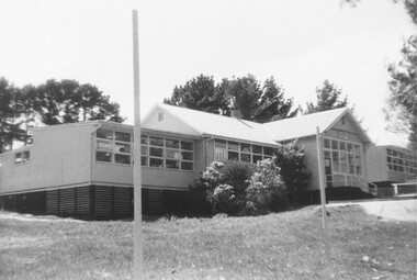
Photograph, External views of North Ringwood State School in Oban Road, including newly completed section - December 1972
Written on back of photograph, "North Ringwood State School. New section, Dec. 1972". -
 Ringwood and District Historical Society
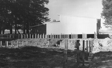
Photograph, Additions to North Ringwood State School, Oban Road, 1973
Written on backing sheet, "North Ringwood State School. Additions to new section 1973". -
 Federation University Historical Collection
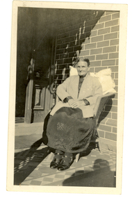
Photograph - Photograph - Black and White, Sarah Wright at 214 Armstrong (North) Street, 1928, 1928
Sarah Wright was married to a gold miner named William. They lived at Laura Villa, Smeaton. Their family won many singing and instrumental awards. Frank Wright their son was born and attended Smeaton State School and was a renown resident of Smeaton. Frank was tutored by Percy Code and was awarded a gold medal for the highest marks in the ALCM examinations in the British Colonies at the age of seventeen years. He became the Australian Open Cornet Champion by the age of eighteen. A year later, Frank conducted the City of Ballarat Band, and later the Ballarat Soldiers’ Memorial Band. He formed the Frank Wright Frisco Band and Frank Wright and his Coliseum Orchestra. These bands won many South Street awards, and Frank as conductor won many awards in the Australian Band Championship contest. In 1933 Frank Wright sailed to England to conduct the famous St Hilda’s Band and was later appointed Musical Director of the London County Council, where he organized many amazing concerts in parks, in and around the London district. He was made Professor of Brass and Military Band Scoring and conducted at the Guildhall of Music and Drama. Frank was often invited to adjudicate Brass Band Championships around Europe, in Australia, including South Street and in New Zealand. The Frank Wright Medal at the Royal South Street competition is awarded to an individual recognized as making an outstanding contribution to brass music in Australia. Laura Ritchie was his sister.Black and white photograph of a woman in a long dark skirt and light cardigan sitting on a chair with a pillow behind her back. The chair is on the verandah of a brick house. The woman is Sarah Wright and the house belongs to her daughter Laura Ritchie at 214 Armstrong St Nth, Ballarat.Written in pen on the back May 1928. Written in pencil 214 Armstrong St Northsarah wright. frank wright, laura ritchie, armstrong street, ballarat -
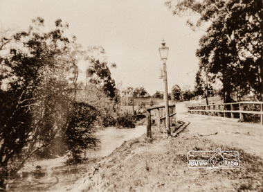
Kew Historical Society Inc
Collection, Floods in North Kew (Series), 1929–1934
Flooding of the Yarra Valley, including that section of the Yarra bordering Kew and Kew East in the north and west of the municipality, was a regular occurrence. Extreme flood events of the Yarra River are recorded to have occurred in 1891, 1901, 1916, 1923 and 1934. The Municipality of Kew's response to these floods was to enact planning decisions restricting residential development in flood prone areas following the floods of 1916, 1921 and 1934. While floods continued after the development of the Upper Yarra Reservoir (construction 1948-57), the regularity and extent of these inundations diminished. Natural disasters had an impact on the development and settlement of Melbourne and its suburbs. Flooding in the Melbourne region was a regular event in the nineteenth and for most of the twentieth centuries. Changes in the impact of natural disasters could occur due to a number of factors. This collection of small snapshots, mostly taken from Kellett Grove in North Kew, provide provenanced evidence of flooding in the area before the development of the unnatural flood barrier that is the Eastern Freeway.Collection of 16 monochrome photographs, annotated on verso by different hands, of the flooding of the River Yarra in North Kew in the third and fourth decades of the twentieth century [1920s & 1930s]. Individual photos include the dates of different floods. Many of the photos were taken from the rear of 8 Kellett Grove; a house still extant in 2023yarra river -- north kew, floods -- yarra valley, floods -- north kew, floods -- 1929, floods -- 1934, natural disasters -- kew -
National Vietnam Veterans Museum (NVVM)
Book, North Africa 1940-1942: the desert war
world war, 1939-1945 - australia, world war, 1939-1945 - campaigns - middle east, world war, 1939-1945 - campaigns - africa, north -
 Flagstaff Hill Maritime Museum and Village
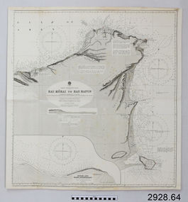
Document - Navigation Chart, Africa - North East Coast - Ras Kòrai to Ras Hafun
British Admiralty Navigation Chart - Africa - North East Coast - Ras Kòrai to Ras Hafunwarrnambool, shipwrecked-coast, flagstaff-hill, flagstaff-hill-maritime-museum, maritime-museum, shipwreck-coast, flagstaff-hill-maritime-village, shipwrecked-artefact, navigation chart, british admiralty navigation chart, british admiralty, ras kòrai to ras hafun, gulf of aden, africa : north east coast -
Ringwood and District Historical Society
Document - School Register, Ringwood Primary School 2997 and Nunawading North No 2242 - computer printouts of school registers 1880-1909, 1880-1909
The registers recorded pupil's name, date of birth, parents' names and occupations, and schools attended with entry and exit dates.Computer printouts of school registers. Ringwood Primary No 2997 and also Nunawading North No 2242. 27pp. -
Federation University Historical Collection
Film, Nanook of the North - silent documentary film, 1922
The documentary follows the lives of an Inuk, Nanook, and his family as they travel, search for food, and trade in the Ungava Peninsula of northern Quebec, Canada. Nanook, his wife Nyla and their family are introduced as fearless heroes who endure rigors no other race could survive. The audience sees Nanook, often with his family, hunt a walrus, build an igloo, go about his day, and perform other tasks.A platic container containing a 16mm film spool of the 1922 silent documentary film Nanook of the Northnanook of the north, william mckenzie, baffin island, belcher islands, arctic -
 Flagstaff Hill Maritime Museum and Village
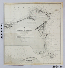
Document - Navigation Chart, Africa - North East Coast - Ras Kòrai to Ras Hafun
British Admiralty Navigation Chart - Africa - North East Coast - Ras Kòrai to Ras Hafunwarrnambool, shipwrecked-coast, flagstaff-hill, flagstaff-hill-maritime-museum, maritime-museum, shipwreck-coast, flagstaff-hill-maritime-village, shipwrecked-artefact, navigation chart, british admiralty navigation chart, british admiralty, ras kòrai to ras hafun -
Lakes Entrance Regional Historical Society (operating as Lakes Entrance History Centre & Museum)
Book, Smith, Ian; Byrne, Gerry; Hanson, Frank, North Arm Foreshore and Estuary Action Plan, 1996
Report of the Action Plan for the future management of the North Arm and its environs, Lakes Entrance, Victoriawaterways, conservation -
 Whitehorse Historical Society Inc.
Photograph, Slater family perfume distillery, North Blackburn, 1/06/1969 12:00:00 AM
Black and white photo of house in North Blackburn incorporating part of the Slater family perfume distillery.slater perfume distillery, blackburn -
 Ballarat Heritage Services
Photograph - Image, Lydiard Street Looking North, c1895, c1895
Black and white image of Lydiard Street looking North. A steam train crossed the railway line. lydiard street ballarat, steam train, streetscape, architecture -
 Buninyong & District Historical Society
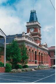
Photograph - Original Photograph, Buninyong Town Hall (1886) front, angle view from North-East, 9/11/1991
historic buildingColour photograph, Buninyong Town Hall (1886) front, angle view from North-East, buninyong, view, town hall -
 Kew Historical Society Inc
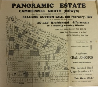
Plan - Subdivision Plan, Panoramic Estate, Camberwell North (Balwyn), 1939, 1939
Subdivision plan advertised as the Panoramic Estate, Balwyn, showing lots for sale in the following streets: Bulleen Road, Macedon Avenue, The Moor, Sunburst Avenue, Doncaster Road, Fortuna Avenue, Longview Road, The Nook, and Touring Avenue.Single page subdivision plan of the Panoramic Estate in Camberwell North (Balwyn); offered for sale in 1939Nilsubdivision plans - balwyn (vic), panoramic estate - camberwell north - balwyn (vic) -
 Federation University Historical Collection
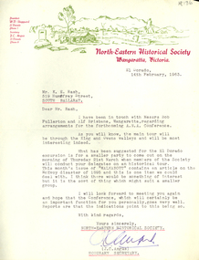
Correspondence, North-Eastern Historical Society Letterhead and correspondence, 1963
1 typed page of paper. North-eastern Historical Society Letterhead. The letter is to Keith Rash and related to Australian Native's Association (ANA) Conference to be held in Wangaratta in 1963. The letter is signed by J.C. Angus, Hion. Secretary of the North-Eastern Historical Society.J.C. Angusnorth-eastern historical society, keith edwin rash, australian natives association, rash, keith rash, angus, ana, el dorado -
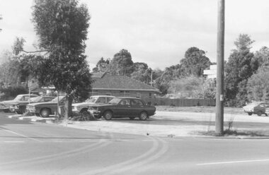 Ringwood and District Historical Society
Photograph, Car park at corner of Dickson Cres. and Warrandyte Road, North Ringwood (undated)
Written on back of photograph, "Car park at corner of Dickson Cres. and Warrandyte Road, North Ringwood". -
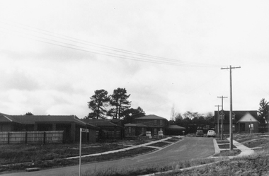
 Ringwood and District Historical Society
Photograph, Corner Kubis and Whitlam Drives, North Ringwood 1982
Written on back of photograph, "21/4/82. No.? corner Kubis and Whitlam Drives, North Ringwood." -
 Ringwood and District Historical Society
Photograph, Lot 63 Whitlam Dr. North Ringwood under construction 1982
Written on back of photograph, "21/4/82. Lot 63 Whitlam Dr. North Ringwood" -
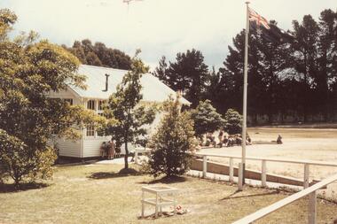
 Ringwood and District Historical Society
Photograph, North Ringwood State School, Oban Road - September 1973
Typed below photograph, "North Ringwood State School with new school at back. September 1973". -
 Ringwood and District Historical Society
Photograph, Marcel Court, North Ringwood - 1981
Written on back of photograph, "E621, N2, 1981. Marcel Court, North Ringwood, looking east". -
 Ringwood and District Historical Society
Photograph, Ringwood Reserve - North east corner. Now Eastland site - 1963
Typed below photograph, "Ringwood Reserve - North east corner. Now Eastland site - 1963" -
 Ringwood and District Historical Society
Photograph, North Ringwood State School, Oban Rd. 11/11/55
Written on back of photograph, "North Ringwood State School, Oban Rd. 11/11/55". -
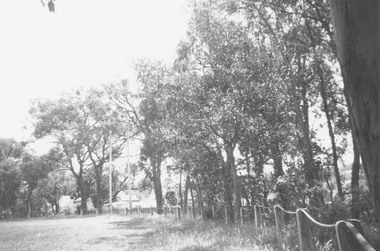
 Eltham District Historical Society Inc
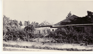
Photograph, Diamond Creek Bridge, Eltham North
Photograph copy of original showing the old Eltham North bridge upstream of present Wattletree Road bridgediamond creed, eltham north, wattletree road, coleman crescent, bridges