Showing 12454 items
matching now and then
-
 Whitehorse Historical Society Inc.
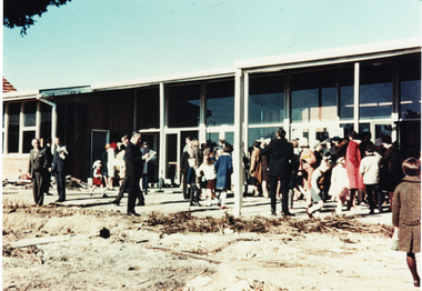
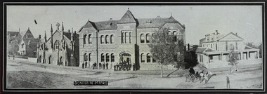
Photograph, Mitcham Methodist Church
Mitcham Methodist Church. Now 339 Mitcham Road - Roads Service Station. Cross Ref: ND1837.methodist church mitcham, glasson, bill -
 Whitehorse Historical Society Inc.
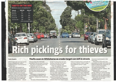
Article, Thefts soar in Whitehorse, 2017
Mitcham is now the second most risky suburb in Whitehorse for thefts with a 76% increase over the past year.mitcham, crime, city of whitehorse -
 Whitehorse Historical Society Inc.
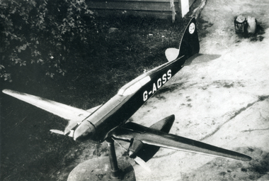
Photograph, Model on house at Creek Road Mitcham, 1939/40
Black and white 1939/40 photograph of model aeroplane on house (now demolished) at Creek Road, Mitchamcreek road, mitcham, thompson, george -
 Kew Historical Society Inc
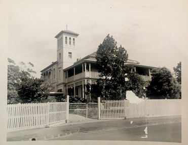
Photograph, J E & B L Rogers, 'Fernhurst', c.1959
This work forms part of the collection assembled by the historian Dorothy Rogers, that was donated to the Kew Historical Society by her son John Rogers in 2015. The manuscripts, photographs, maps, and documents were sourced by her from both family and local collections or produced as references for her print publications. Many were directly used by Rogers in writing ‘Lovely Old Homes of Kew’ (1961) and 'A History of Kew' (1973), or the numerous articles on local history that she produced for suburban newspapers. Most of the photographs in the collection include detailed annotations in her hand.The Rogers Collection provides a comprehensive insight into the working habits of a historian in the 1960s and 1970s. Together it forms the largest privately-donated collection within the archives of the Kew Historical Society.Small, black and white photo of Fernhurst in Kew, built for the architect and surveyor George Wharton. (Now demolished)"Probably built in 1860s / Fernhurst"fernhurst -- kew (vic), historical houses -- kew (vic), kew mansions -
 Stawell Historical Society Inc
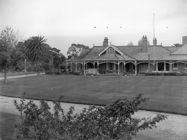
Photograph, “Swinton” Homestead in Glenorchy with a flagpole on the front lawn
B/W photo of “Swinton” Homestead with flagpole on front lawn. B/W. Photograph: of Swinton Similar to view on 0236. The light seems to be relocated and there is now a stone drive.glenorchy -
 Federation University Art Collection
Photography (colour), 'University of Ballarat Historical Collection' by Julie Millowick, 2008
Millowick produced photographs highlighting community museums of the Victorian Goldfields for the exhibition "Objects Faces Places. This work highlights objects from the Ballarat School of Mines, a predecessor of Federation University Australia. This item is part of the Federation University Art Collection. The Art Collection features over 2000 works and was listed as a 'Ballarat Treasure' in 2007.An image of selected artefacts from the University of Ballarat Historical Collection (now Federation University Historical Collection).art, artwork, millowick, photography, available, historical collection, ballarat school of mines, museum -
 University of Melbourne, Burnley Campus Archives
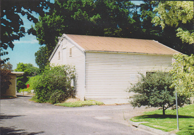
Photograph - Colour print, The Dairy Shed in 1990, 1990
Appears to have been used in an exhibitionCaption, "The dairy shed in 1990, by now reclad. In the 1980's it was used for storage of landscape and arboriculture equipment."dairy shed, storage, equipment -
 Tarnagulla History Archive
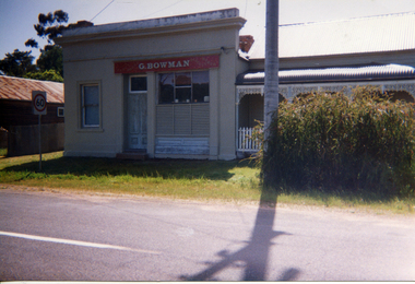
Photograph, Bowman's Store, Tarnagulla, early 1990s
Donald Clark Collection. A colour photograph depicting a building, formerly Bowman's Store, in Tarnagulla. Now a private residence. Original photograph. -
 St Patrick's Old Collegians Association (SPOCA)
Photograph - History, Crests
-
Linton Mechanics Institute and Free Library Collection
Book - Novel, Van Dine, S. S, The Bishop Murder Case, 1933
Crime fiction.315 p. : dark grey cover, embossed with gold, pattern of small stars (now very faded).fictionCrime fiction.fiction, s. s. van dine -
![Congregational Church, Walpole Street [Kew], 1977](/media/collectors/550653872162f11fb04854aa/items/58ce3037d0ce2f09d89eafac/item-media/58cf5d86d0ce9a3314909edb/item-fit-380x285.jpg) Kew Historical Society Inc
Kew Historical Society IncPhotograph, Unknown, Congregational Church, Walpole Street, 1977
The Congregational Church was built on the site of the first church in Kew. This church, the second on the site, was designed by the Kew architect Charles Vickers and opened in 1860. The distinctive polychrome brick façade designed by Vickers contrasted with the style that he employed for other churches he designed during this period; they were usually constructed in bluestone. In the 1960s, a new ministry saw the erection of a neon cross at the apex of the church. The illuminated cross could be seen from Church Street, Hawthorn. The church was later to be demolished, and the land sold for the construction of modern villas. Photograph of an historic church in Kew by noted architects Charles Vickers and Alfred Purchas.Congregational Church, Walpole Street, Kew, 1977 (now demolished). View of the polychrome facade facing Walpole Street. The use of polychrome brick by Alfred Purchas (the second architect) reflects his preference for this architectural style, such as in his design for Tarring (now Ruyton Girls' School)Inscriptions on reverse: "KH-100. Congregational Church Walpole St Kew. First church built in Kew 1860. Chapel on site 1854. Became a member of the United Churches 1970s". congregational church, walpole street (kew), charles vickers -
 Federation University Historical Collection
Photograph - Photograph - black and white, Ballarat School of Mines, Lydiard Street, Ballarat, c1909, c1909
Ballarat School of Mines was established in 1870 making it Australia's first School of Mines. It is now Federation University Australia SMB Campus.Ballarat School of Mines from Lydiard Street. The former Wesley Church is on the left of the photo. Beside it is the New Classrooms (now Administration Building), and the former Ballarat Circuit Court which was demolished in 1912 and replaced the the Ballarat Technical Art School building. .1) Sepia print .2) Black and white print showing all the Lydiard Street streetscape with people in the doorway and a horse and buggy in the street. .3) Black and white copy .4) Line drawing taken from the photo.ballarat school of mines, lydiard street, ballarat, administration buildings, former circuit court, former wesley church, administration building, a building, former methodist church -
 Kew Historical Society Inc
Plan - Subdivision Plan, Jas R Mathers Son & McMillan, Macartney Estate, East Kew, c. 1925
Pru Sanderson, in her groundbreaking ‘City of Kew Urban Conservation Study : Volume 2 - Development History’ (1988), summarised the periods of urban development and subdivisions of land in Kew. The periods that she identified included 1845-1880, 1880-1893, 1893-1921, 1921-1933, 1933-1943, and Post-War Development. These periods were selected as they represented periods of rapid growth or decline in urban development. An obvious starting point for Sanderson’s groupings involved population growth and the associated economic cycles. These cycles also highlighted urban expansion onto land that was predominantly rural, although in other cases it represented the decline and breakup of large estates. A number of the plans in the Kew Historical Society’s collection can also be found in other collections, such as those of the State Library of Victoria and the Boroondara Library Service. A number are however unique to the collection.Subdivision plans are historically important documents used as evidence of the growth of suburbs in Australia. They frequently provide information about when the land was sold on which a built structure was subsequently constructed as well as evidence relating to surveyors and real estate and financial agents. The numerous subdivision plans in the Kew Historical Society's collection represent working documents, ranging from the initial sketches made in planning a subdivision to printed plans on which auctioneers or agents listed the prices for which individual lots were sold. In a number of cases, the reverse of a subdivision plan in the collection includes a photograph of a house that was also for sale by the agent. These photographs provide significant heritage information relating house design and decoration, fencing and household gardens.The Macartney Estate subdivision advertised 21 lots for sale on either side of Macartney Street (now Macartney Avenue) and Evans Road in what was then designated as East Kew. Most of the houses shown on the south side of Macartney Street then, as now, have rear entrances on Mount Street, however a number of these blocks have since been further subdivided to allow for the building of new houses on the rear of a block. Brougham Place is marked on the plan but is now called Daniell Place."C"subdivision plans - east kew, macartney estate, macartney street, mount street, evans road, brougham place -
 Wodonga & District Historical Society Inc
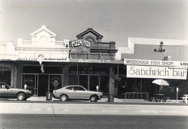
Photograph - Codling Collection 01 - High Street East - Malibu Ice Cream Parlour, Crystal's Pizza and Wodonga Fish Shop, c1980
Miss Olive Codling was a Foundation Member and a Life Member of the Wodonga Historical Society. Many of her prize-winning photos are held in the Society Collection. She also held a range of roles and committee positions in a wide range of Wodonga community organisations. These included the Horticultural Society, the Wodonga Arts Council, the Wodonga Camera Club and the Wodonga Lapidary Club. This photo collection is significant as it documents how the businesses and buildings in Wodonga have evolved and contributed to community throughout the 20th century.Businesses located in High Street. Wodonga north of the recently developed Mann Central. Malibu Ice Cream was at one time McSwiney’s Chemist, and is now High X-Posure Lingerie. For a short time it was also the premises of Pauls Ski Shop, now located in Thomas Mitchell Drive, Wodonga. Crystal's Pizza was at one time Dempster's Café and is now Junction Pizza. In 2021 Wodonga Fish Shop is the location of Greg's Takeaway which was established in 1988.wodonga businesses, high st wodonga, malibu ice cream, crystals pizza, wodonga fish shop -
 City of Kingston
Photograph - Black and white
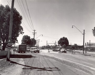
This photograph depicts the road diversion on Nepean Highway that was implemented to allow construction of the railway line underneath the Nepean Highway at Moorabbin. An "Allourie" Cheese, Honey Canned Ham van is prominent on the left of the image, the railway gates are central and the old Moorabbin Station is visble. Beyond the dates, pedestrians are visible crossing the Nepean Highway. This image is part of a larger collection of images from the Public Transport Corporation displaying train stations and streetscapes in what is now the City of Kingston.In 1958 excavations began for the removal of the level crossing gates at the southern end of the Moorabbin shopping centre on Nepean Highway. The station was also lowered below ground. A diversion route was created to enable the flow of traffic in both directions along the highway.Black and white photograph of road diversion on Nepean Highway, Moorabbin to allow the construction of the railway line below the Nepean Highway at Moorabbin and also to trench the station. This image is part of a larger collection of images from the Public Transport Corporation displaying train stations and streetscapes in what is now the City of Kingston.White adhesive dot sticker: Printed black 199 Handwritten in red ink: 80% Handwritten in black ink on yellow Post-It Note: [indecipherable] 199 - Diversion for Crossing Stamped in blue ink: COPYRIGHT Public Transport Corporation, For reordering photographs, Please quote negative No m 5687, Enquiries C/- PTC Photographic Unit, Telephone switchboard 619 1111railway crossing, railway station, city of moorabbin -
 Ballarat Tramway Museum
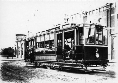
Photograph - Black & White Photograph/s, 1912
Yields information about the form and style of the early Geelong trams.Black and white photograph, printed onto card (inkjet printer?) of Geelong No. 7, at the depot, then Corio Terrace, now Brougham Street Geelong 1912. Has a number of men on board the tram - depot workers for the photograph? Shows as built details of the tramcar. Two copies held. Dave O'Neil advised 20/7/2009 - test tram prior to formal opening.Copy 1 on rear "Emerging from Depot 1912", "W.F. Scott Collection", "Geelong Historical Society" in Bill Scot's handwriting and in bottom right hand corner "William F. Scott" address label. and "14" in top left hand corner. Copy 2 - "Geelong Hist Soc / William F Scott Collection / Car outside the depot in Corio Tce (now called Brougham Street)"tramways, trams, geelong, depot, brougham st, tram 7 -
 Greensborough Historical Society
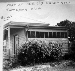
Photograph - Digital image, Mavis Solum's old home, 1950s
Photograph of the home of the Thomas family. Mavis Solum (nee Thomas) provided the photograph to accompany an oral history, published in "As I Recall".Digital copy of black and white photograph.Written on photograph: "Part of our old home now Kurrajong Avenue - Thomas"mavis solum, solum family -
 Ringwood and District Historical Society
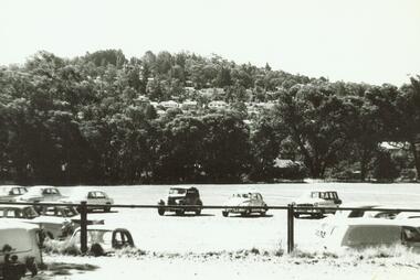
Photograph, Ringwood Oval (now Eastland) looking at Loughnan's Hill with cars in car park (mid-late 1960's)
Notes courtesy Peter Fry: FC Holden = post 1958, Simca Aronde - was around until '60's. Morris 1100 released February 17th 1964 so photo is later that this - probably mid to late 1960'sWritten on back of photograph, "Ringwood Oval (now Eastland) looking at Loughnan's Hill". -
 Ringwood and District Historical Society
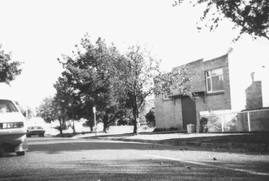
Photograph, Masonic Hall, now demolished. Ringwood 1978 (2 images)
Catalogue card reads, "Masonic Hall, now demolished". Photograph is dated 1978. -
 Ringwood and District Historical Society
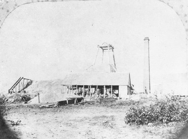
Photograph, Antimony Mine c1880
Black and white photograph of mine building with poppet head behind and tall chimney to right of picture. (3 copies)Typed below photograph, "Antimony Mine. Now Civic Centre site, c1880". -
 Cheese World Museum
Advertisement, Vickers Tractors
Vickers of Sheffield in England manufactured armaments in the WWI period. In the early 1920s commenced manufacturing tractors under license to International Harvester. This tractor was aimed at the Australian market and called the 'Aussie' with the first available in 1925 but lack of sales forced Vickers to abandon tractor manufacture by 1930. This advertisement is part of the Uebergang Collection of rural items given into the care of the Cheese World Museum. . The Uebergang family came from Silesia to Australia in 1848 and were early settlers in the Allansford area. The sons and other descendants also purchased farms in the area. The Percy Uebergang family lived at Tooram Park, Allansford from 1912 until 1992. Percy and Myrtle Uebergang's children were twins, Ray and Joyce born in 1926 who lived at Tooram Park until their deaths, Ray in 1986 and Joyce in 1992 after which the property was sold. Neither Ray nor Joyce married and following the death of her brother Joyce set up the Ray and Joyce Uebergang Foundation which supports the local community. The collection of items from their property was put into store for a number of years before being given into the care of the Cheese World Museum. The family often re-used, recycled and repaired items and examples can be seen in the museum. A4 size advertisement cut from a newspaper showing the Vicker's tractors new features and a drawing of the tractor.Built by Vicker's Ltd/Vicker's Tractors/And Now a Better Vickers than ever.allansford, vickers tractors, tractors, advertisements -
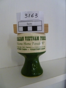 National Vietnam Veterans Museum (NVVM)
Memorabilia, Earthenware Cup
Cream and green cupAustralian Vietnam Forces "Welcome Home Parade 87" "Together Then - Together Now"commemorative cup, welcome home parade -
 St Kilda Historical Society
Photograph, Grand Hotel (now Windsor), c. 1890s
black and white photograph (two), fair conditionGrand Hotel (now Windsor), Spring St, Melbourne. Late 1800's. -
![Villa, Park Crescent [Kew], circa 1965](/media/collectors/550653872162f11fb04854aa/items/578d9a23d0cdd105b87e6465/item-media/578d9a54d0cdd105b87e7c2a/item-fit-380x285.jpg) Kew Historical Society Inc
Kew Historical Society IncPhotograph, Villa, Park Crescent [Kew], circa 1965, c. 1965
This work forms part of the collection assembled by the historian Dorothy Rogers, that was donated to the Kew Historical Society by her son John Rogers in 2015. The manuscripts, photographs, maps, and documents were sourced by her from both family and local collections or produced as references for her print publications. Many were directly used by Rogers in writing ‘Lovely Old Homes of Kew’ (1961) and 'A History of Kew' (1973), or the numerous articles on local history that she produced for suburban newspapers. Most of the photographs in the collection include detailed annotations in her hand.The Rogers Collection provides a comprehensive insight into the working habits of a historian in the 1960s and 1970s. Together it forms the largest privately-donated collection within the archives of the Kew Historical Society.Single storey brick villa located in Park Crescent, Kew.First house in Park Cres. Area then known as Hyde Park. Now altered.park crescent, kew, dorothy rogers -
 Kew Historical Society Inc
Photograph, 'Rangeview', Mary Street, c.1960
This work forms part of the collection assembled by the historian Dorothy Rogers, that was donated to the Kew Historical Society by her son John Rogers in 2015. The manuscripts, photographs, maps, and documents were sourced by her from both family and local collections or produced as references for her print publications. Many were directly used by Rogers in writing ‘Lovely Old Homes of Kew’ (1961) and 'A History of Kew' (1973), or the numerous articles on local history that she produced for suburban newspapers. Most of the photographs in the collection include detailed annotations in her hand.The Rogers Collection provides a comprehensive insight into the working habits of a historian in the 1960s and 1970s. Together it forms the largest privately-donated collection within the archives of the Kew Historical Society.Small black and white photograph of 'Rangeview' in Mary Street, Kew."Rangeview. Chapter 52. Commenced about 1880. Now altered to Baptist Hostel"historic houses -- kew (vic.), rangeview -- mary street -- kew (vic.) -
Whitehorse Historical Society Inc.
Document, A Welsh librarian, c2004
An item in a series: 'Our octogenarians' published in the Mountview Uniting Church magazine.An item in a series: 'Our octogenarians' published in the Mountview Uniting Church magazine. Joyce Suto was born in Wales as one of a large family. After training as a Librarian she migrated to Australia in 1955 where she married a Hungarian migrant. She has worked in various libraries ending at Donvale High School. She now lives in Pinetrees Retirement Village, Donvale.An item in a series: 'Our octogenarians' published in the Mountview Uniting Church magazine. baker, joyce, suto, joyce, suto, louis, mountview uniting church, mitcham, jones, julie, bird, julie, libraries -
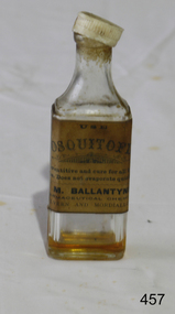 Flagstaff Hill Maritime Museum and Village
Container - Bottle, Early - Mid 20th Century
This is an earlier example of how mosquitos and other annoying insect bites were treated.Quick treatment of insect bites could often prevent the development of serious medical conditions and diseases.Bottle clear glass originally containing liquid. Now empty. Marked "M. Ballantyne". Plastic top broken.‘Use Mosouitofly. A preventative and cure for all insect bites. Does not evaporate quickly. M Ballantyne, Pharmaceutical Chemist, Malvern & Mordiallac.' flagstaff hill, warrnambool, shipwrecked-coast, flagstaff-hill, flagstaff-hill-maritime-museum, maritime-museum, shipwreck-coast, flagstaff-hill-maritime-village, mosquitos, insects, first aid, medicine, bites -
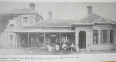
 Glen Eira Historical Society
Caulfield Properties
Photograph of Glen Huntly built by Thomas Watts, date unknown, on site of where Holy Cross church now isglen huntly, glen huntly road, houses, watts, thomas, holy cross church, churches -
 Glen Eira Historical Society
Caulfield Properties
Photograph of Glen Huntly built by Thomas Watts, date unknown, on site of where Holy Cross church now isglen huntly, glen huntly road, houses, watts, thomas, holy cross church, churches -
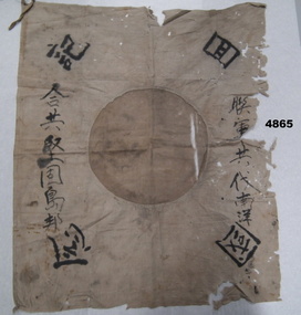 Bendigo Military Museum
Flag - FLAG, JAPANESE, C.1930 - 1945
As per wording supplied by the donor. Flag found on the body of a Japanese soldier by a Coast Watcher found by villagers. He was from a Japanese submarine of New Guinea possibly near Popondetta. It was found hanging in a Long House Papua New Guinea and swapped for a Slouch hat in 1972. Some of the writing is possibly, “On land or sea brothers we are”.Japanese flag with central circle now brownish colour was possibly red as new, around outside are Japanese wording.“Japanese symbols”flags, japanese