Showing 527 items
matching panoramas
-
 Eltham District Historical Society Inc
Postcard - Photograph postcard, Panorama at Eltham, Vic, c.1923
The Rose Series P. 4284 post card Taken from near what would be present day CLC car park looking southwest across Diamond Street, present-day Andrew Park to the railway station and developing Eltham shopping precinct. Arthur Street visible, Pryor and Luck Street not evident. Sunnybrook, the Taylor home is visible at the top of the hill in Bible Street. Only three residences visible in Arthur Street on the southern side, two of these are the David Harbison Rest Home at 10 and 12 Arthur Street (built and opened in November 1919), present day site of Eltham Mall. There are none on the north side of the street. Based on 1945 aerial view there are 8 buildings on the northern side between Main Road and Bible Street which and given the extent of commercial development on Main Road, it is estimated this image is circa 1925. Luther Haley was the first to build an open a baker and General Store in this location next to the railway station in 1902. However, it took nearly twenty years until the early to mid-1920s when a period of significant growth in the Eltham shopping centre happened with many businesses relocating their operations from the original town centre of Maria Street in Little Eltham as well as new businesses opening. Other stores/buildings noted (L-R) are: Stationmaster's House built circa 1910 Eltham Hardware Store opposite the railway station first opened on Main Road opposite the Railway Station around late 1922. An advertisement placed in the Hurstbridge Advertiser advised that the Hardware Store had just opened with a varied stock of Saws, Hammers, Nails, Shovels, Screw Drivers, and every article required in a house or on a farm. People were also encouraged to try their Jams, Pickles, Sauces, Cups and Saucers, etc. Newsagency with 'Leader' advertising on awning - E. J. Andrew opened his newsagency shop opposite the station in March 1923, advertising for sale stationery, school requisites and periodicals. Bird Brothers Cash Grocer & Fruiterer opposite the railway station offering summer drinks and confectionery a specialty with a full Stock of groceries of the best quality always on hand at city prices opened December 1921 William Capewell's Butcher shop at the corner of Dudley Street. Capewell previously had a small shop in front of the station opposite Luck Street. He enlisted in the AIF during WW1 and returned home in 1919. He re-applied for a slaughtering license in February 1920 and was advertising by October 1922 supplying all districts. Not visible (or not yet identified) but in business by October 1922 were: J.H. Fraser, Carpenter and Builder at Luck Street opposite the station George A. Danslow, Hairdresser and Tobacconist opposite the railway station Miss Barber's 'Blue Gum' Soda Fountain opened October 1922 opposite the railway station (hidden behind Stationmaster's House). It was so named due to its proximity to a tall Blue Gum tree G.H. McDonald Boot Repairer opposite the railway station In December 1923 the first portion of the main street to be formed from Dudley to Arthur streets was almost completed. This is the section in front of Capewell's Butcher shop though it is difficult to fully make out from the photoDigital file only Postcards scanned from the collection of Michael Aitken on loan to EDHS, 2 Sep. 2022michael aitken collection, eltham, postcards, arthur street, david harbison rest home, electrine candles, eltham railway station, eltham shopping centre, lloyd's general store, red rattler, rose series postcard, rose stereograph company, tait train, velvet soap, andrew park, bible street, bird brothers cash grocer & fruiterer, bird brothers cash grocer and fruiterer, butcher, diamond street, dudley street, eltham hardware and timber, eltham hardware store, eltham mall, main road, station masters house, stationmaster's house, sunnybrook, w.j. capewell, w.j. capewell butcher shop -
 Eltham District Historical Society Inc
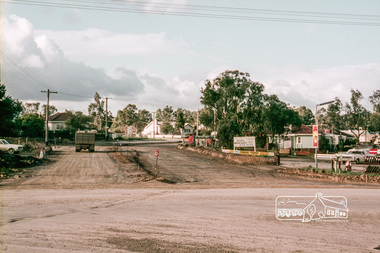
Slide, Reconstruction of Grand Boulevard viewed from Panorama Avenue, Montmorency, 18 August 1970, 1970
The Eltham Apex Club conducted a Community Service Project (1965-1968) to raise funds for a new Ambulance Station to service the community. A site bounded by the intersection of Main Road, Grand Boulevard and Looker Road at Montmorency was purchased in 1969. In 1970, Eltham Shire Council undertook roadworks to construct Apex Way in preparation for the new station as well as duplicate Main Road, Lower Plenty, east of Grand Boulevard including the new Lower Plenty Bridge, which had been opened in November 1966, bordering with the City of Heidelberg.35 mm colour positive transparency Mount - Agfacolor Service (Blue)1970-08-18, apex-diamond valley ambulance station, eltham ambulance station, eltham apex club, grand boulevard, montmorency -
 Eltham District Historical Society Inc
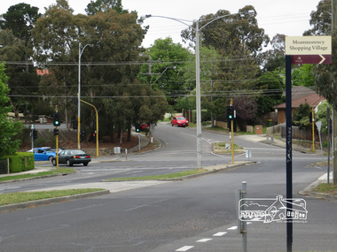
Photograph, Liz Pidgeon, Intersection of Grand Boulevard and Panorama Avenue with Main Road, Montmorency, 7 November 2017, 7 Nov 2017
2 born digital imagesgrand boulevard, main road, montmorency, panorama avenue, streets -
 Eltham District Historical Society Inc
Slide, Mitchell Avenue near Panorama Heights Preschool, Montmorency, c.Oct. 1980
One of a series of images of roads and infrastructure focussed on the Quinn Estate in Montmorency taken by Eltham Shire Council Planning and Engineering officers. They provide perspective of the changes in housing styles and road development that began sweeping in from the mid 1970s with increasing urbanisation of what was once more outlying suburbs and regions.35 mm colour positive transparency Mount - Kodak Kodachrome CardProcessed Oct 1980infrastructure, mitchell avenue, montmorency, panorama heights preschool, roads -
 Eltham District Historical Society Inc
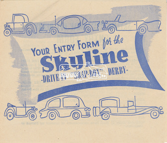
Entry Form, Entry form for the Skyline Drive-In “Soap-Box” Derby, to be held along Main Road between Panorama Avenue and Bolton Street, Easter Saturday, 20 April 1957, 1957
1957 was the ninth show held in aid of the Eltham War Memorial Trust.6 page double fold, double sided, printed in blue1957, billy cart, billy cart derby, bolton steet, easter gymkhana, eltham easter gymkhana 1957, eltham war memorial trust, hoyt's skyline drive-in theatres, panorama avenue, soap box derby, soap-box derby -
 Marysville & District Historical Society
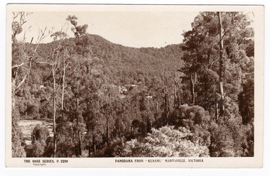
Postcard (item) - Black and white postcard, Rose Stereograph Company, Panorama From "Kerami", Marysville, Victoria, 1913-1967
A postcard in a series produced by the Rose Stereograph Company in Victoria, Australia as a souvenir of Marysville.An early postcard of the view of Marysville from "Kerami", Marysville, Victoria. Kerami was a guesthouse in Marysville that was destroyed in the 2009 Black Saturday bushfires.POST CARD THE "ROSE" SERIES/ DE LUXE/ REAL PHOTOS PUBLISHED IN/ AUSTRALIA Published by the Rose Stereographs/ Armadale/ Victoriakerami, marysville, victoria, p.2299, rose series postcard, postcard, souvenir, guesthouse -
 Marysville & District Historical Society
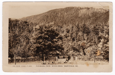
Postcard (item) - Black and white postcard, Rose Stereograph Company, Panorama From "Wych Cross," Marysville, Vic, 1913-1967
A postcard in a series produced by the Rose Stereograph Company in Victoria, Australia as a souvenir of Marysville.A black and white photograph showing a panoramic view from Wych Cross which was a guesthouse in Marysville. The Wych Cross Private Guesthouse was part of the Wych Cross Private Hotel Co. Ltd of which Mr. Felix Jellicoe was Managing Director at the time. The guesthouse burnt down in a fire on the 14th of November, 1926. This fire started in the kitchen where it was soon extinguished by one of the employees. However, it is believed that sparks from the earlier fire, which were not noticed at the time, ignited the second fire which destroyed the weatherboard guesthouse in 20 minutes. Guests who were staying at the guesthouse were all away from the premises at the time of the fire and lost all their belongings; including one guest who lost a considerable sum of money.POST CARD REAL PHOTO/ THE "ROSE" SERIES DE LUXE PRODUCED IN AUSTRALIA Published by "The Rose Stereographs"/ Armadale, Victoria. "Sunnyside"/ Marysville/ 18/12/26 Dear Mr & Mrs De La Rue/ Just a line/ or two in which to convey the very/ best of good wishes. A very happy/ Christmas and Happy New Year/ to you and your family./ Yours sincerely Mrs. & Miss Newman. wych cross, marysville, victoria, p. 4959, rose series postcard, postcard, souvenir, wych cross hotel co ltd, felix jellicoe, guest house, 14th november 1926 -
 Marysville & District Historical Society
Photograph (item) - Black and white photographs, Rose Stereograph Company, Rose Series Picturesque Views of Marysville Australia, 1913-1967
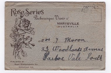
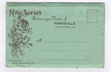
A series of photographs produced by the Rose Stereograph Company in Victoria, Australia as a souvenir of Marysville.Souvenir envelope containing 12 black and white photographs of natural attractions in Marysville and surrounding area. Published by Rose Stereograph Co, Armadale, Victoria.Rose Series/ Picturesque Views of/ MARYSVILLE/ AUSTRALIA PUBLISHED BY/ ROSE STEREOGRAPH CO/ ARMADALE, VIC. Mrs. J Moron/ 23 Woodlands Avenue/ Pascoe Vale South The date stamp is illegible.the taggerty river marysville vic (image 1), panorama from mt gordon marysville vic (image 2), cora lynn falls marysville vic (image 3), cumberland-cora lynn trip marysville vic at the meeting of the waters (image 4), michael dene marysville vic (image 5), nichols lookout marysville vic (image 6), the stevenson river marysville vic (image 7), cathederal mount from mt gordon marysville vic (image 8), stevenson falls marysville vic (image 9), mountain ash tallest known hardwood tree in world (301ft 6in) cumberland marysville vic (image 10, the main street marysville vic (image 11), talbot drive vic no 12 taggerty river (image 12), rose stereograph company, souvenir, marysville, victoria -
 Marysville & District Historical Society
Photograph (item) - Black and white photographs, Rose Stereograph Company, Rose Series Picturesque Views of Marysville Australia, 1913-1967
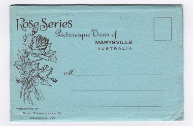
A series of photographs produced by the Rose Stereograph Company in Victoria, Australia as a souvenir of Marysville.Souvenir envelope containing 12 black and white photographs of natural attractions in Marysville and surrounding area. Published by Rose Stereograph Co, Armadale, Victoria.Rose Series/ Picturesque Views of/ MARYSVILLE/ AUSTRALIA PUBLISHED BY/ ROSE STEREOGRAPH CO/ ARMADALE, VIC.the taggerty river marysville vic (image 1), panorama from mt gordon marysville vic (image 2), cora lynn falls marysville vic (image 3), cumberland-cora lynn trip marysville vic at the meeting of the waters (image 4), michael dene marysville vic (image 5), nichols lookout marysville vic (image 6), the stevenson river marysville vic (image 7), cathederal mount from mt gordon marysville vic (image 8), stevenson falls marysville vic (image 9), mountain ash tallest known hardwood tree in world (301ft 6in) cumberland marysville vic (image 10, the main street marysville vic (image 11), talbot drive vic no 12 taggerty river (image 12), souvenir, rose stereograph company, marysville, victoria -
 Marysville & District Historical Society
Photograph (item) - Black and white photographs, Rose Stereograph Company, Rose Series Picturesque Views of Marysville Australia, 1913-1967
A series of photographs produced by the Rose Stereograph Company in Victoria, Australia as a souvenir of Marysville.Souvenir envelope containing 12 black and white photographs of natural attractions in Marysville and surrounding area. Published by Rose Stereograph Co, Armadale, Victoria.Rose Series/ Picturesque Views of/ MARYSVILLE/ AUSTRALIA PUBLISHED BY/ ROSE STEREOGRAPH CO/ ARMADALE, VIC.the taggerty river marysville vic (image 1), panorama from mt gordon marysville vic (image 2), cora lynn falls marysville vic (image 3), cumberland-cora lynn trip marysville vic at the meeting of the waters (image 4), michael dene marysville vic (image 5), nichols lookout marysville vic (image 6), the stevenson river marysville vic (image 7), cathederal mount from mt gordon marysville vic (image 8), stevenson falls marysville vic (image 9), mountain ash tallest known hardwood tree in world (301ft 6in) cumberland marysville vic (image 10, the main street marysville vic (image 11), talbot drive vic no 12 taggerty river (image 12), marysville, rose stereograph company, souvenir, victoria -
 Marysville & District Historical Society
Photograph (item) - Black and white photographs, Rose Stereograph Company, Rose Series Picturesque Views of Marysville Australia, 1913-1967
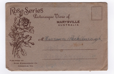
A series of photographs produced by the Rose Stereograph Company in Victoria, Australia.Souvenir envelope containing 12 black and white photographs of natural attractions in Marysville and surrounding area. Published by Rose Stereograph Co, Armadale, Victoria.Rose Series/ Picturesque Views of/ MARYSVILLE/ AUSTRALIA PUBLISHED BY/ ROSE STEREOGRAPH CO/ ARMADALE, VIC. M Lorraine Mickelburoughthe taggerty river marysville vic (image 1), panorama from mt gordon marysville vic (image 2), cora lynn falls marysville vic (image 3), cumberland-cora lynn trip marysville vic at the meeting of the waters (image 4), michael dene marysville vic (image 5), nichols lookout marysville vic (image 6), the stevenson river marysville vic (image 7), cathederal mount from mt gordon marysville vic (image 8), stevenson falls marysville vic (image 9), mountain ash tallest known hardwood tree in world (301ft 6in) cumberland marysville vic (image 10, the main street marysville vic (image 11), talbot drive vic no 12 taggerty river (image 12), marysville, rose stereograph company, souvenir, victoria -
 Marysville & District Historical Society
Photograph (item) - Black and white photographs, Rose Stereograph Company, Rose Series Picturesque Views of Marysville Australia, 1913-1967
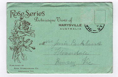
A series of photographs produced by the Rose Stereograph Company in Victoria, Australia as a souvenir of Marysville.Souvenir envelope containing 12 black and white photographs of natural attractions in Marysville and surrounding area. Published by Rose Stereograph Co, Armadale, Victoria.Rose Series/ Picturesque Views of/ MARYSVILLE/ AUSTRALIA PUBLISHED BY/ ROSE STEREOGRAPH CO/ ARMADALE, VIC. Miss Jessie Parkhurst/ "Flowerdale"/ Romsey. Vic. From Medythe taggerty river marysville vic (image 1), panorama from mt gordon marysville vic (image 2), cora lynn falls marysville vic (image 3), cumberland-cora lynn trip marysville vic at the meeting of the waters (image 4), michael dene marysville vic (image 5), nichols lookout marysville vic (image 6), the stevenson river marysville vic (image 7), cathederal mount from mt gordon marysville vic (image 8), stevenson falls marysville vic (image 9), mountain ash tallest known hardwood tree in world (301ft 6in) cumberland marysville vic (image 10, the main street marysville vic (image 11), talbot drive vic no 12 taggerty river (image 12), marysville, rose stereograph company, souvenir, victoria -
 Lara RSL Sub Branch
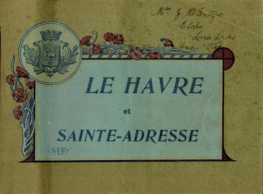
Booklet, Le Havre et Sainte-Adresse, circa 1917
Le Havre is an urban French commune and city in the Seine-Maritime department in the Normandy region of northwestern France. It is situated on the right bank of the estuary of the river Seine on the Channel southwest of the Pays de Caux. The sixteen photos are from circa 1917.Important Booklet as it shows rare photos of an area in France during WW1.Booklet with light cardboard cover bounded by red stringFront page is crest with poppies and titled Le Havre et Sainte-Adresse with initials E.L.D (printers initials). Written in pen on the top right corner are the words Mrs J.McIntyre Elcho Lara Lake Aus - Vic. On the back page is a stamp, Catalogues Industriels E. Le Deley 127, Boulevard Sebastopol, Paris Inside are photos of of the area around Le Havre, Franceelcho, lara lake, le havre, france, ww1, world war one, mcintrye, j. mcintrye, vue general, l'hotel de ville, sainte-adresse, vue d'ensemble du boulevard maritime, sainte-adresse - la heve, sainte-adresse - ensemble du nice-havrais, le casino et la plage, bassin du commerce, sainte-adresse - boulevard felix-faure, panorama pris de l'hotel de ville et rue de paris, le transatlantique "france" 220m de long entrant au port, "la provence" entrant au port par gros temps, sainte-adresse - ensemble du nice-havrais et des nouvelles villas, place gambetta, le nouveau casino marie-christine 1910, le pont du commerce et la bourse -
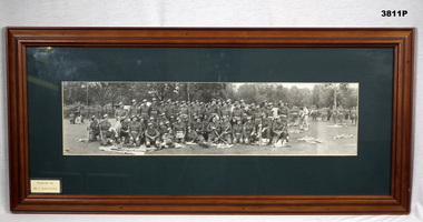 Bendigo Military Museum
Photograph - PHOTOGRAPH WW2, FRAMED, Bethany Gallery, C.WW2
The exact unit is not clearly known at this stage.Photo, black white, of soldiers in full uniform, some with 303 rifles. Trees in background with family gatherings each side of the main group. Mounted with green border, tan wooden frame with glass front, fawn cardboard backing with silver wire hanging strap on rear.“21 - - - - - HQ”photograph, panorama, group -
 Federation University Historical Collection
Photograph, Panorama of the Gippsland Institute of Advanced Education Campus, 1980s
Gippsland Institute of Advanced Education campus official openinggippsland campus collection, churchill, gippsland institute of advanced education -
 Greensborough Historical Society
Slide - Photograph, John Ramsdale, Rural panorama: Slide 14
Photograph shows view across a road and open land to large house in a rural setting. At the time of the photograph was named 'Odyssey House' at Lower Plenty, Pre 1976 it was known as the Blessed Sacrament Fathers Seminary.Part of the John Ramsdale collection of slides and audio visual material.Colour photograph scanned from slide.No maker's marks. No caption on slide.rural landscape -
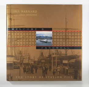 Mission to Seafarers Victoria
Book, Jill Barnard et al, Welcome and Farewell: The Story of Station Pier, 2004
In the mid-nineteenth century, Victoria’s primitive maritime infrastructure was not coping with the volume of passenger and cargo traffic arriving in and departing from the burgeoning gold-fevered colony. However, the opening of Railway Pier at Port Melbourne in 1854 greatly improved the situation. Railway Pier serviced the steamships, which plied Port Phillip Bay and the Victorian coastal waters beyond, and also offered berths for vessels on the regular runs to other Australian colonies and to overseas destinations. However, as the larger and more powerful steamships of the early twentieth century found berthing increasingly difficult at Railway Pier, the need for a more modern pier became apparent. By 1930, the new Station Pier had replaced its predecessor. Itself extended and upgraded several times including during the past decade, Station pier still offers every contemporary convenience to shipping services using its busy facilities, just as did its predecessor Railway Pier, 150 years ago. The Victorian Government commissioned Welcome & Farewell to celebrate the 150 years since the opening of the Railway Pier. In doing so, it was mindful that the story of the site is not limited to its contribution to national and state economies, or to its physical development. The Government wanted a history that would also speak to ordinary Victorians, and other Australians, of their own experiences of this significant place. For indeed the Station Pier site has played its part in almost every milestone or phase in our history: at moments of celebration and commemoration, during economic booms and depressions, during times of war and peace. It has also won a place in the hearts of ordinary individuals affected by the welcomes and farewells they have experienced there: those for visiting royalty and celebrities, for servicemen and medical personnel off to war or returning home, for migrants from distant countries and refugees from war zones, for friends and family travelling for personal, professional or cultural reasons. Welcome & Farewell thoughtfully examines Station Pier’s significance and offers a splendid visual panorama of the experiences lived out there between 1854 and 2004.Illustrated large-format book with 224 pages [36] p. of plates. : ill., maps, ports.Bibliography: p. 199-201non-fictionIn the mid-nineteenth century, Victoria’s primitive maritime infrastructure was not coping with the volume of passenger and cargo traffic arriving in and departing from the burgeoning gold-fevered colony. However, the opening of Railway Pier at Port Melbourne in 1854 greatly improved the situation. Railway Pier serviced the steamships, which plied Port Phillip Bay and the Victorian coastal waters beyond, and also offered berths for vessels on the regular runs to other Australian colonies and to overseas destinations. However, as the larger and more powerful steamships of the early twentieth century found berthing increasingly difficult at Railway Pier, the need for a more modern pier became apparent. By 1930, the new Station Pier had replaced its predecessor. Itself extended and upgraded several times including during the past decade, Station pier still offers every contemporary convenience to shipping services using its busy facilities, just as did its predecessor Railway Pier, 150 years ago. The Victorian Government commissioned Welcome & Farewell to celebrate the 150 years since the opening of the Railway Pier. In doing so, it was mindful that the story of the site is not limited to its contribution to national and state economies, or to its physical development. The Government wanted a history that would also speak to ordinary Victorians, and other Australians, of their own experiences of this significant place. For indeed the Station Pier site has played its part in almost every milestone or phase in our history: at moments of celebration and commemoration, during economic booms and depressions, during times of war and peace. It has also won a place in the hearts of ordinary individuals affected by the welcomes and farewells they have experienced there: those for visiting royalty and celebrities, for servicemen and medical personnel off to war or returning home, for migrants from distant countries and refugees from war zones, for friends and family travelling for personal, professional or cultural reasons. Welcome & Farewell thoughtfully examines Station Pier’s significance and offers a splendid visual panorama of the experiences lived out there between 1854 and 2004.port melbourne, station pier -
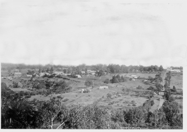 Greensborough Historical Society
Photograph - Digital image, Panorama Overlooking Greensborough, 1925c
Photograph shows the view overlooking the Greensborough township in the first half of the 20th Century. It shows the rural nature of the area.Digital copy of black and white photograph.greensborough -
 Greensborough Historical Society
Book, Greenhills Panorama, 1959_
Relates the history of the Greenhills area of Greensborough. It was compiled by Malcolm Blair, Agnes O'Donnell and Adrienne Thompson as an entry into a Develop Victoria Council contest in 1959.Records the significant developments in Greenhills' history. It also listed the office bearers of the Greenhill and North Greensborough Progress Association from its inception.A 40 page singled sided typed book held together by staples. 3 copies.greenhills, partington, gold discovery, north greensborough, anthony beale, st helena, develop victoria council -
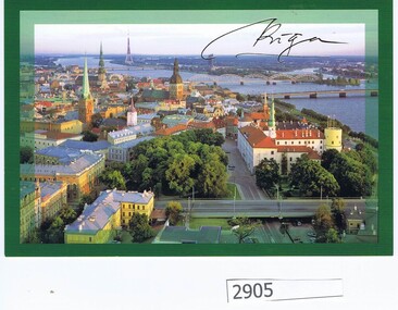 Greensborough Historical Society
Postcard, Panorama of Riga, 21/08/2016
Atis Lejins was a former resident of Greensborough.- and is a member of the Latvian Parliament.Colour postcard of Riga, with stamped envelope addressed to Noel Withers, President GHS."To GHS, with greetings on the very day Latvia's independence was fully restored in 1991, 21 Aug, 25 years ago" [from] Atis Lejinslatvia, atis lejins -
 Glenelg Shire Council Cultural Collection
Negative - Negative - panorama of Nelson, Victoria, 1934
Part of a collection of photographs taken by Zillah Maschmedt in 1934. Zillah was a teacher from South Australia.Transparency for black and white photo. Panoramic view of Nelson Viczillah maschmedt, photography, panorama, glenelg river, nelson -
Glenelg Shire Council Cultural Collection
Photograph - Photograph - Panorama of the Harbour, Portland, n.d
Unknown -
 Kiewa Valley Historical Society
Photograph of Kiewa Valley Panorama, Farming lands within the Kiewa Valley in1950s, Circa 1950
This photograph shows how (early to mid1900s), before the establishment of the Mount Beauty "gated" village, the Kiewa Valley was farmed and the scarce population was spread out over acres of productive land. This photograph catches a time before (what appeared to the local farmers as the invasion by a mass of construction workers) when this remote valley was part of a "lay back" rural landscape,occasionally visited by friends and some wayward tourists. The mountain ranges provided an adequate barrier against the way-would traveller. The immigration numbers coming into Australia was still quite small ( due to the "white" Australia policy) which was in force before World War II. After World War II a mass of displaced European refugees and migrants boosted the Australian population and provided for a greater degree of diverse professions and rural related work force.This photograph depicts the borderline in time between an exclusively rural based population and respective activities(early 1900s)to the present (2000 on wards) integrated village, tourist and retiree/holiday area. The time when land was exclusively used in agriculture is over and the impact of cheaper rural produce from Asian markets will see a shift of land useage and population activities. The Kiewa Valley is loosing its hiding place and is becoming more and more a source of untapped residential land. Black and white photograph of farming/grazing land useage, before the establishment of the Mount Beauty Village. Small pockets of residentual houses can be viewed. Road access (unsealed dirt) was typical of that provided in rural regions in the 1950s. The photo is on 200gms paper and not on photographic paper.kiewa valley in the early1900s, grazing in the kiewa valley, sec victoria -
 Kiewa Valley Historical Society
Photograph of Kiewa Valley Panorama, Kiewa Valley from No. 5 Road, Before 1945
In 1943 a camp for workmen was erected and a commencement made with the erection of plant storage and workshop buildings in the new township of Mt. Beauty. The photograph was probably taken after the completion of these buildings. There is no sign of construction of the town itself. In the latter part of 1945 work was commenced on the Mt. Beauty township area with a medical centre, general trading store and some houses under construction. The No. 5 Road, from where the photograph was taken, is the road to West Kiewa Power Station and Big Hill Scenic Lookout.Is an excellent view of the Kiewa Valley before there was little work undertaken to establish the town of Mt. Beauty. Farming was well established with the evidence of huge areas of cleared land. The junction of the East and West Kiewa Rivers can be clearly seen. The first Workmen's camp is near the river and some workshop buildings can also be seen. Black and white photograph of the Kiewa Valley, looking North.Handwritten on the back of photograph "Kiewa Valley from No. 5 Road".kiewa valley, camp, buildings, mt. beauty -
 Sir Reginald Ansett Transport Museum
Journal - Journal, Monthly, Panorama, The Journal of Ansett Airlines of Australia, Vol.23, No 5, June 1981, 1981
In 1981, Ansett Australia introduced a new look for their uniforms. The designer was Adele Weiss, wife of Peter Weiss.The journal and the uniforms displayed at the museum, demonstrate the collaboration between Ansett and two Australian fashion designers.Colour printed journal with illustrations1981, uniform, stewardess, hostess, flight attendant, adele weiss -
 Australian Commando Association - Victoria
Memorabilia - Carved wooden Pen Holder with 2/6 colour patch - manufacturer Bill Grenfell 45 Panorama Drive Alstonville NSW 2477
-
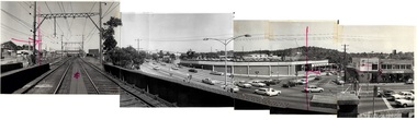 Ringwood and District Historical Society
Photograph (item) - Panorama Compilation, Maroondah Hwy Warrandyte Rd from Railway - 4 photo compilation
-
 Marysville & District Historical Society
Photograph (Item) - Black and white photograph, Unknown
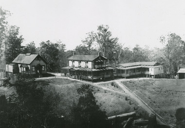
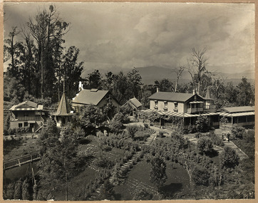
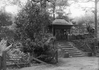
An early black and white photograph of "The Hermitage" at Narbethong in Victoria.An early black and white photograph of "The Hermitage" at Narbethong in Victoria. "The Hermitage" was built by photographer John William Lindt as a home and guesthouse in 1894. John Lindt had previously photographed the mountain scenery of the Black Spur and purchased 71 acres and subseqently built his home and guesthouse from where he continued his career. "The Hermitage had a garden designed by John Lindt's friend, Ferdinand von Mueller, who was at one stage the Director of the Melbourne Botanic Gardens. The garden featured New Guinea tree houses from which John Lindt made frequent panoramas of his property and the surrounding forest of towering mountain ash. Aged 81 Lindt died of heart failure during disastrous bushfires on 19 February 1926 at the Hermitage. He was survived by his wife Catherine who continued to run ‘The Hermitage’ guest house before she retired to the city.the hermitage, john william lindt, narbethong, victoria, black spur, ferdinand von mueller, melbourne botanic gardens, new guinea, catherine lindt -
 Marysville & District Historical Society
Photograph (Item) - Black and white photograph, John William Lindt, 1890-1910
A digital copy of an early black and white photograph taken of "The Hermitage" in Narbethong in Victoria.A digital copy of an early black and white photograph taken of "The Hermitage" in Narbethong in Victoria. "The Hermitage" was built by photographer John William Lindt as a home and guesthouse in 1894. John Lindt had previously photographed the mountain scenery of the Black Spur and purchased 71 acres and subseqently built his home and guesthouse from where he continued his career. "The Hermitage had a garden designed by John Lindt's friend, Ferdinand von Mueller, who was at one stage the Director of the Melbourne Botanic Gardens. The garden featured New Guinea tree houses from which John Lindt made frequent panoramas of his property and the surrounding forest of towering mountain ash. Aged 81 Lindt died of heart failure during disastrous bushfires on 19 February 1926 at the Hermitage. He was survived by his wife Catherine who continued to run ‘The Hermitage’ guest house before she retired to the city.the hermitage, john william lindt, narbethong, victoria, black spur, ferdinand von mueller, melbourne botanic gardens, new guinea, catherine lindt -
 Marysville & District Historical Society
Photograph (Item) - Black and white photograph, John William Lindt, 1910
A digital copy of an early black and white photograph of the entrance gate to "The Hermitage" at Narbethong in Victoria.A digital copy of an early black and white photograph of the entrance gate to "The Hermitage" at Narbethong in Victoria. "The Hermitage" was built by photographer John William Lindt as a home and guesthouse in 1894. John Lindt had previously photographed the mountain scenery of the Black Spur and purchased 71 acres and subseqently built his home and guesthouse from where he continued his career. "The Hermitage had a garden designed by John Lindt's friend, Ferdinand von Mueller, who was at one stage the Director of the Melbourne Botanic Gardens. The garden featured New Guinea tree houses from which John Lindt made frequent panoramas of his property and the surrounding forest of towering mountain ash. Aged 81 Lindt died of heart failure during disastrous bushfires on 19 February 1926 at the Hermitage. He was survived by his wife Catherine who continued to run ‘The Hermitage’ guest house before she retired to the city. Visitors to the Hermitage alighted from horse-drawn vehicles and later motor coaches to enter the estate through the lich-gate in the background.the hermitage, john william lindt, narbethong, victoria, black spur, ferdinand von mueller, melbourne botanic gardens, new guinea, catherine lindt