Showing 841 items matching "parish plan"
-
 Bacchus Marsh & District Historical Society
Map, Bullengarook Parish, County of Bourke
... An undated parish plan map for the parish of Bullegarook...A single page paper map showing the parish plan map...An undated parish plan map for the parish of Bullegarook ...An undated parish plan map for the parish of Bullegarook. This parish area is close to the Bacchus Marsh district and borders some of the areas contained within the former Bacchus Marsh Shire and present day Moorabool Shire.A single page paper map showing the parish plan map for Bullengarook. This parish area contains the locality of Bullengarook and parts of the Wombat State Forest and is close to the town of Gisborne. A cadastral map showing land ownership. The map is not dated but a very similar map held by the State Library of Victoria is estimated to date from about 1927. The map is pasted into a bound volume containing 76 maps or plans in total. High resolution digital image stored on BMDHS computer network. bullengarook parish maps -
 Bendigo Historical Society Inc.
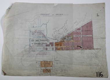
Map - WALMER, Circa 1900
... Map: Township of Walmer, 2 hand Draughted Parish plans... Draughted Parish plans Map WALMER ...Map: Township of Walmer, 2 hand Draughted Parish plansmap, township, walmer -
 Bendigo Historical Society Inc.
Map - JACK FLYNN COLLECTION: TOWNSHIP OF STANHOPE, December 1950
... of Rodney. Parish plan.... of Girgarre, County of Rodney. Parish plan. Map JACK FLYNN COLLECTION ...Map: Township of Stanhope, Parish of Girgarre, County of Rodney. Parish plan.By Authority J. J. Gourley, Government Printer, Melbourne. Drawn and Reproduced at the Dept, of Lands and Survey, Melbourne, Victoria.map, rodney, township, stanhope -
 Bendigo Historical Society Inc.
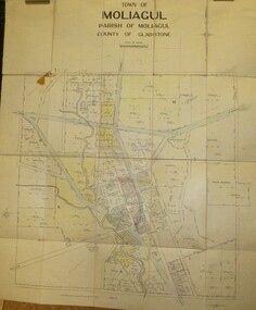
Map - JACK FLYNN COLLECTION: MOLIAGUL, 7/02/1931
... of Gladstone. Parish plan.... of Moliagul, County of Gladstone. Parish plan. Map JACK FLYNN ...Map: Township of Moliagul, Parish of Moliagul, County of Gladstone. Parish plan.map, gladstone, township, moliagul -
 Bendigo Historical Society Inc.
Map - JACK FLYNN COLLECTION: GIRGARRE, 1957
... of Rodney. Parish plan.... of Kyabram, County of Rodney. Parish plan. Map JACK FLYNN COLLECTION ...Map: Township of Girgarre, Parish of Kyabram, County of Rodney. Parish plan.By Authority: W. M. Houston, Government Printer, Melbourne. Drawn and reproduced at the Department of Lands and Survey, Melbourne.map, rodney, township, girgarre -
 Bendigo Historical Society Inc.
Map - JACK FLYNN COLLECTION: GOORNONG, August 1953
... of Bendigo. Parish plan.... of Goornong, County of Bendigo. Parish plan. Map JACK FLYNN COLLECTION ...Map: Township of Goornong, Parish of Goornong, County of Bendigo. Parish plan.By Authority W.M. Houston. Government Printer. Drawn and Reproduced at the Dept., of Lands and Survey, Melbourne, Victoria. August 1953map, bendigo, township, goornong -
 Bendigo Historical Society Inc.
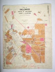
Map - TOWN OF INGLEWOOD, March 1946
... of Gladstone. Parish plan..., Parish of Inglewood, County of Gladstone. Parish plan Map TOWN ...Map: Town of Inglewood, Parish of Inglewood, County of Gladstone. Parish planmap, gladstone, township, inglewood -
 Bendigo Historical Society Inc.
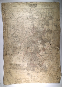
Map - NERRING, 25/08/1903 ?
... Map: Parish of Nerring, County of Bendigo. Parish plan... of Nerring, County of Bendigo. Parish plan Canvas backed Map NERRING ...Map: Parish of Nerring, County of Bendigo. Parish plan Canvas backedmap, bendigo, rural, nerring, county of bendigo -
 Bendigo Historical Society Inc.
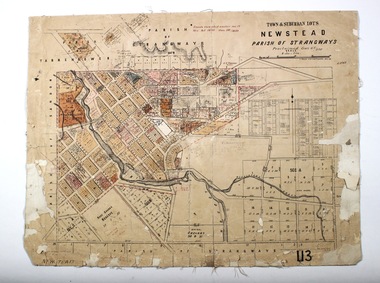
Map - NEWSTEAD, 28/07/1874
... . Parish plan..., Parish of Strangways. Parish plan Map NEWSTEAD ...Map: Newstead Town and Suburban Lots, Parish of Strangways. Parish planmap, township, newstead -
 Bendigo Historical Society Inc.
Map - CAMPBELL COLLECTION: BENDIGO AND DISTRICT MAPS, 2-2-29
... parish plan... Bendigo parish plan W.J.Galbraith Map. Wellsford, Parishes ...Map. Wellsford, Parishes of Wellsford and Axedale, Scale 20 chains to 1 inch. Total area 4994 acres. Prepared in W.P.B. from A and P Plans, by W.J.G.2-2-29. Top left of map are directions to Fosterville, Huntly & Bendigo. (number 361 in map cupboard 1)W.J.Galbraithmap, bendigo, parish plan -
Bendigo Historical Society Inc.
Map - CAMPBELL COLLECTION: BENDIGO AND DISTRICT MAPS, 15-2-29
... parish plan... Bendigo parish plan W.J.Galbraith Map. Nerring, Parish of Nerring ...Map. Nerring, Parish of Nerring, scale 20 chains to 1 inch. Prepared in W.J.B. from A and B plans by W.J. Galbraith 15-2-29. (number 356 in map cupboard 1)W.J.Galbraithmap, bendigo, parish plan -
 Bendigo Historical Society Inc.
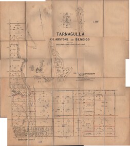
Map - JACK FLYNN COLLECTION: TARNAGULLA SHEET 1, No date visible
... parish plan... Gladstone parish plan Tarnagulla Sheet 1 Map: Parish of Tarnagulla ...Map: Parish of Tarnagulla Sheet 1, Counties of Gladstone and Bendigo.map, gladstone, parish plan, tarnagulla sheet 1 -
 Bendigo Historical Society Inc.
Map - JACK FLYNN COLLECTION: TARNAGULLA, 13/05/1922
... parish plan... Gladstone parish plan Tarnagulla By Authority, A. J. Mullen ...Map: Parish of Tarnagulla . This Item is in very poor condition.By Authority, A. J. Mullen, Government Printer, Melbourne. Lithographed at the Department of Lands and Survey, Melbourne by W. J. Butsonmap, gladstone, parish plan, tarnagulla -
 Bendigo Historical Society Inc.
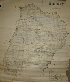
Map - JACK FLYNN COLLECTION: RODNEY, Revised in 1935
... parish plan... Rodney parish plan Rodney Drawn at the Department of Lands ...Map: County of Rodney, map sheet showing the whole of the County of Rodney and all of the Parishes within.Drawn at the Department of Lands and Survey, Melbourne. Revised to 1935map, rodney, parish plan, rodney -
 Bendigo Historical Society Inc.
Map - JACK FLYNN COLLECTION: COUNTY OF GLADSTONE, 1934
... parish plan... Gladstone parish plan Gladstone Engraved at the Department of Lands ...Map: County of Gladstone, map sheet showing the whole of the County and the Parishes within. Scale 2 Miles to 1 inch.Engraved at the Department of Lands and Survey Melbourne. 1958. By Authority of W.M. Houston, Government Printermap, gladstone, parish plan, gladstone -
 Bendigo Historical Society Inc.
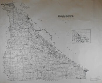
Map - JACK FLYNN COLLECTION: COUNTY OF GUNBOWER, 1935
... parish plan... Gunbower parish plan Gunbower Map; County of Gunbower. Sheet ...Map; County of Gunbower. Sheet containing the whole of the County, showing parishes within. Scale 2 Miles to 1 inch.map, gunbower, parish plan, gunbower -
Bendigo Historical Society Inc.
Map - KANGAROO FLAT SUBDIVISION, 26/11/1900
... parish plan... Bendigo parish plan Kangaroo Flat Parish of Sandhurst County ...Map: Plan of Subdivision at Kangaroo flat, Parish of Sandhurst, County of Bendigo ( number 149 in Map Cupboard 1)map, bendigo, parish plan, kangaroo flat, parish of sandhurst, county of bendigo -
Bendigo Historical Society Inc.
Map - MANDURANG, 8/10/1887
... parish plan... Bendigo parish plan Mandurang Re-survey Couny of Bendigo Parish ...Parish of Mandurang, County of Bendigo. Traced from a re-survey of the Parish of Mandurang by Mr. Geo. Black 8/10.1887 ( number 158 in Map Cupboard 1)map, bendigo, parish plan, mandurang, re-survey, couny of bendigo -
Bendigo Historical Society Inc.
Map - TARNAGULLA SHEET 3, No date Visible
... parish plan... parish plan Tarnagulla Map: Tarnagulla Sheet 3, hand written ...Map: Tarnagulla Sheet 3, hand written on the side of the map. ( number 152 in Map Cupboard 1)map, parish plan, tarnagulla -
Bendigo Historical Society Inc.
Map - NERRING SHEET 2, 21/12/1894
... parish plan... Bendigo parish plan Nerring Map[: Nerring sheet 2 ( number 187 ...Map[: Nerring sheet 2 ( number 187 in Map Cupboard 1)map, bendigo, parish plan, nerring -
Bendigo Historical Society Inc.
Map - BENDIGO (COUNTY), Circa 1870's
... parish plan... Commons Sandhurst District'. Also attached is a separate plan... Bendigo parish plan Bendigo Proclaimed Commons Map:Plan showing ...Map:Plan showing the whole of the County of Bendigo-- attached handwritten sheet in the top left hand corner-'Proclaimed Commons Sandhurst District'. Also attached is a separate plan of the parish of Kimbolton (number 262 in map cupboard 1)map, bendigo, parish plan, bendigo, proclaimed commons -
Bendigo Historical Society Inc.
Map - PARISH OF MARONG, 24/09/1874
... parish plan... Bendigo parish plan Marong Map; Parish of Marong ,County ...Map; Parish of Marong ,County of Bendigo. This plan has been cut and then applied to a different backing. ( number 234 in Map Cupboard 1)map, bendigo, parish plan, marong -
Bendigo Historical Society Inc.
Map - WELLSFORD, 4/07/1876
... parish plan... Bendigo parish plan Wellsford Map: Parish of Wellsford, County ...Map: Parish of Wellsford, County of Bendigo. Strathfieldsaye, Wellsford , Bagshot (number 311 in map cupboard 1)map, bendigo, parish plan, wellsford -
Bendigo Historical Society Inc.
Map - BRIDGEWATER, 10/09/1913
... parish plan... Bendigo parish plan Bridgewater Map: Bridgewater, Parishes ...Map: Bridgewater, Parishes of Bridgewater and Inglewood, Counties of Bendigo and Gladstone (number 276 in map cupboard 1)map, bendigo, parish plan, bridgewater -
 Bacchus Marsh & District Historical Society
Map, Village allotments, Parish of Myrniong, County of Bourke
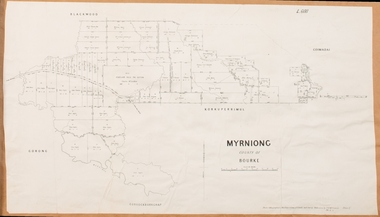
... Myrniong Parish Plan... Parish Plan Myrniong Parish Maps Surveyed by John Hardy, Surveyor ...Myrniong is a village 9 kilometers west of Bacchus Marsh. Prior to 1863 the area was known as Blow's Flat. This map which was produced in 1903 and according to the catalogue record of this map held at the State Library of Victoria was based on an earlier map created in 1861. The early layout of streets for the village of Myrniong can be seen on this map. The streets shown are, Main Street, Hardy Street, Blow Street, Myrniong Street, Shuter Street, and Blackwood Street. An area marked as a reserve for a school can be seen between Hardy Street and Main Street.A single page paper map. A cadastral parish map of Myrniong in Victoria, showing numbered land allotments. Photo-lithographed at the Department of Lands & Survey, Melbourne, in 1903. Based on an original map created in 1861. The map is pasted into a bound volume containing 76 maps or plans in total. High resolution digital image stored on BMDHS computer network. Surveyed by John Hardy, Surveyor ; photo-lithographed at the Department of Lands & Survey, Melbourne by T.F. McGauran, 24.12.03myrniong parish plan, myrniong parish maps -
 Bacchus Marsh & District Historical Society
Map, Myrniong Parish Map 1904
... Myrniong Parish Plan...Myrniong Parish Plan Myrniong Parish Maps Bacchus Marsh ...A single page paper map showing the map for the Parish of Myrniong in the County of Bourke. A cadastral map showing parish boundaries and land ownership. The map is pasted into a bound volume containing 76 maps or plans in total. High resolution digital image stored on BMDHS computer network. myrniong parish plan, myrniong parish maps, bacchus marsh region parish plans -
 Bacchus Marsh & District Historical Society
Map, Parwan Parish Map, County of Grant, 1909
... Parwan Parish Plan...Bacchus Marsh Region Parish Plans Parwan Parish Maps Parwan ...A single page paper map showing the map for the Parish of Parwan in the County of Grant. A cadastral map showing parish boundaries and land ownership. The map is pasted into a bound volume containing 76 maps or plans in total. High resolution digital image stored on BMDHS computer network. Photo-lithographed at the Department of Lands and Survey, Melbourne by T.F. McGauran, 7.7.09. bacchus marsh region parish plans, parwan parish maps, parwan parish plan -
 Bacchus Marsh & District Historical Society
Map, Trentham Parish Map 1905 Copy 1
... Trentham Parish Plan...Trentham Parish Maps Trentham Parish Plan Bacchus Marsh ...A single page paper map showing the map for the Parish of Trentham in the Counties of Dalhousie and Bourke. A cadastral map showing parish boundaries and land ownership. The map is pasted into a bound volume containing 76 maps or plans in total. High resolution digital image stored on BMDHS computer network. Photo-lithographed at the Department of Lands and Survey, Melbourne by T.F. McGauran 22.3.05 trentham parish maps, trentham parish plan, bacchus marsh region parish plans -
 Bacchus Marsh & District Historical Society
Map, Coimadai Parish Map, County of Bourke. Circa 1890s-1900s
... Coimadai Parish Plan... Region Parish Plans Coimadai Parish Maps Coimadai Parish Plan ...The cadastral Parish of Coimadai, a subdivision of the County of Bourke, lies directly north of the township of Bacchus Marsh. The date of this map is uncertain. T.F. McGauran the person who made a photo-lithographic copy of the map was in charge of photo-lithography at the Victorian Department of Lands and Survey in the late 19th century until about 1910.A single page paper map showing the map for the Parish of Coimadai in the County of Bourke. A cadastral map showing parish boundaries and land ownership. A rectangle shaped area is missing from the centre of the map due to a tear or deliberate excision. The map is pasted into a bound volume containing 76 maps or plans in total. High resolution digital image stored on BMDHS computer network. Photo-lithographed at the Department of Lands and Survey, Melbourne by T.F. McGauran 26.8.[??] NOTE. Photo litho from L.P showing temporary surveys and occupation of land prepared for departmental use onlybacchus marsh region parish plans, coimadai parish maps, coimadai parish plan