Showing 1538 items
matching primary state school
-
 Greensborough Historical Society
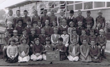
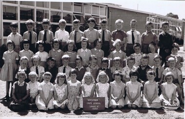
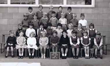
Photograph - School Photograph - Digital Image, Watsonia State School Wa4838 1961 Grade 1A, 1961_
... watsonia primary school watsonia state school Digital copy ...A class photograph of Watsonia State School 1961 Grade 1ADigital copy of a black and white class photographwatsonia primary school, watsonia state school -
 Greensborough Historical Society
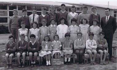
Photograph - School Photograph - Digital Image, Watsonia State School Wa4838 1962 Grade 5/6B, 1962_
... watsonia primary school watsonia state school Digital copy ...A class photograph of Watsonia State School 1962 Grade 5/6BDigital copy of a black and white class photographwatsonia primary school, watsonia state school -
 Greensborough Historical Society
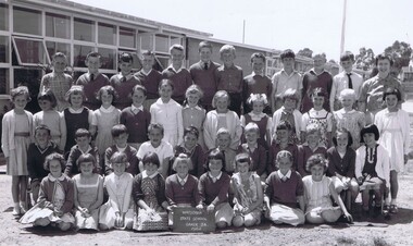
Photograph - School Photograph - Digital Image, Watsonia State School Wa4838 1962 Grade 3A, 1962_
... watsonia primary school watsonia state school Digital copy ...A class photograph of Watsonia State School 1962 Grade 3ADigital copy of a black and white class photographwatsonia primary school, watsonia state school -
 Greensborough Historical Society
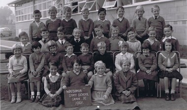
Photograph - School Photograph - Digital Image, Watsonia State School Wa4838 1961 Grade 1C, 1961_
... watsonia primary school watsonia state school Digital copy ...A class photograph of Watsonia State School 1961 Grade 1CDigital copy of a black and white class photographwatsonia primary school, watsonia state school -
 Greensborough Historical Society
Photograph - School Photograph - Digital Image, Watsonia State School Wa4838 1962 Grade 1C, 1962_
... watsonia primary school watsonia state school Digital copy ...A class photograph of Watsonia State School 1962 Grade 1CDigital copy of a black and white class photographwatsonia primary school, watsonia state school -
 Greensborough Historical Society
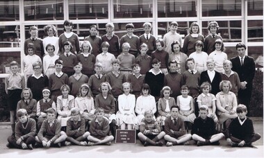
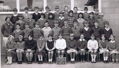
Photograph - School Photograph - Digital Image, Watsonia State School Wa4838 1965 Grade 6A, 1965_
... watsonia primary school watsonia state school Digital copy ...A class photograph of Watsonia State School 1965 Grade 6ADigital copy of a black and white class photographwatsonia primary school, watsonia state school -
 Greensborough Historical Society
Photograph - School Photograph - Digital Image, Watsonia State School Wa4838 1965 Grade 1D, 1965_
... watsonia primary school watsonia state school Digital copy ...A class photograph of Watsonia State School 1965 Grade 1DDigital copy of a black and white class photographwatsonia primary school, watsonia state school -
 Greensborough Historical Society
Photograph - School Photograph - Digital Image, Watsonia State School Wa4838 1965 Grade 4B, 1965_
... watsonia primary school watsonia state school Digital copy ...A class photograph of Watsonia State School 1965 Grade 4BDigital copy of a black and white class photographwatsonia primary school, watsonia state school -
 Greensborough Historical Society
Photograph - School Photograph - Digital Image, Watsonia State School Wa4838 1966 Grade 1D, 1966_
... watsonia primary school watsonia state school Digital copy ...A class photograph of Watsonia State School 1966 Grade 1DDigital copy of a black and white class photographwatsonia primary school, watsonia state school -
 Greensborough Historical Society
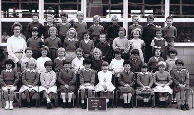
Photograph - School Photograph - Digital Image, Watsonia State School Wa4838 1966 Grade 5B, 1966_
... watsonia primary school watsonia state school Digital copy ...A class photograph of Watsonia State School 1966 Grade 5BDigital copy of a black and white class photographwatsonia primary school, watsonia state school -
 Greensborough Historical Society
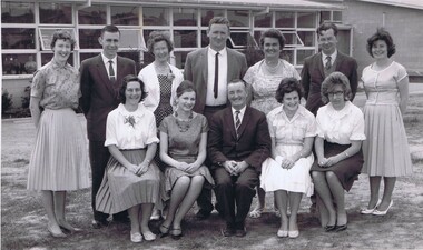
Photograph - School Photograph - Digital Image, Watsonia State School Wa4838 1962 Staff, 1962_
... watsonia primary school watsonia state school teachers Digital copy ...A class photograph of Watsonia State School 1962 StaffDigital copy of a black and white class photographwatsonia primary school, watsonia state school, teachers -
 Greensborough Historical Society
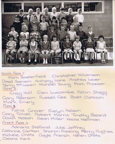
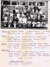
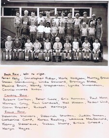
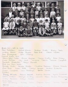
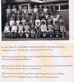
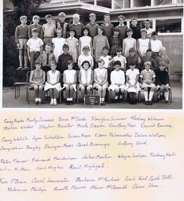
Photograph - School Photograph - Digital Image, Watsonia State School Wa4838 1968 Grade 1A, 1968_
... 1968 Grade 1A watsonia primary school watsonia state school ...A class photograph and caption of Watsonia State School 1968 Grade 1ADigital copy of a black and white class photograph with names written under photo. A word document with typed student names.watsonia primary school, watsonia state school -
 Greensborough Historical Society
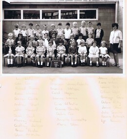
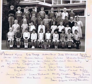
Photograph - School Photograph - Digital Image, Watsonia State School Wa4838 1968 Grade 1B, 1968_
... 1968 Grade 1B watsonia primary school watsonia state school ...A class photograph and caption of Watsonia State School 1968 Grade 1BDigital copy of a black and white class photograph with names written under photo. A word document with typed student names.watsonia primary school, watsonia state school -
 Greensborough Historical Society
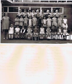
Photograph - School Photograph - Digital Image, Watsonia State School Wa4838 1968 Grade 1D, 1968_
... 1968 Grade 1D watsonia primary school watsonia state school ...A class photograph and caption of Watsonia State School 1968 Grade 1DDigital copy of a black and white class photograph with names written under photo. A word document with typed student names.watsonia primary school, watsonia state school -
 Greensborough Historical Society
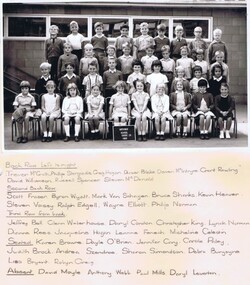
Photograph - School Photograph - Digital Image, Watsonia State School Wa4838 1968 Grade 1E, 1968_
... 1968 Grade 1E watsonia primary school watsonia state school ...A class photograph and caption of Watsonia State School 1968 Grade 1EDigital copy of a black and white class photograph with names written under photo. A word document with typed student names.watsonia primary school, watsonia state school -
 Greensborough Historical Society
Photograph - School Photograph - Digital Image, Watsonia State School Wa4838 1968 Grade 1C, 1968_
... 1968 Grade 1C watsonia primary school watsonia state school ...A class photograph and caption of Watsonia State School 1968 Grade 1CDigital copy of a black and white class photograph with names written under photo. watsonia primary school, watsonia state school -
 Greensborough Historical Society
Photograph - School Photograph - Digital Image, Watsonia State School Wa4838 1968 Grade 1F, 1968_
... 1968 Grade 1F watsonia primary school watsonia state school ...A class photograph and caption of Watsonia State School 1968 Grade 1FDigital copy of a black and white class photograph with names written under photo. A word document with typed student names.watsonia primary school, watsonia state school -
 Greensborough Historical Society
Photograph - School Photograph - Digital Image, Watsonia State School Wa4838 1968 Grade 1G, 1968_
... 1968 Grade 1G watsonia primary school watsonia state school ...A class photograph and caption of Watsonia State School 1968 Grade 1GDigital copy of a black and white class photograph with names written under photo. A word document with typed student names.watsonia primary school, watsonia state school -
 Greensborough Historical Society
Photograph - School Photograph - Digital Image, Watsonia State School Wa4838 1968 Grade 1H, 1968_
... 1968 Grade 1H watsonia primary school watsonia state school ...A class photograph and caption of Watsonia State School 1968 Grade 1HDigital copy of a black and white class photograph with names written under photo. A word document with typed student names.watsonia primary school, watsonia state school -
 Greensborough Historical Society
Photograph - School Photograph - Digital Image, Watsonia State School Wa4838 1968 Grade 2A, 1968_
... 1968 Grade 2A watsonia primary school watsonia state school ...A class photograph and caption of Watsonia State School 1968 Grade 2ADigital copy of a black and white class photograph with names written under photo. A word document with typed student names.watsonia primary school, watsonia state school -
 Greensborough Historical Society
Photograph - School Photograph - Digital Image, Watsonia State School Wa4838 1968 Grade 2B, 1968_
... 1968 Grade 2B watsonia primary school watsonia state school ...A class photograph and caption of Watsonia State School 1968 Grade 2BDigital copy of a black and white class photograph with names written under photo. A word document with typed student names.watsonia primary school, watsonia state school -
 Greensborough Historical Society
Photograph - School Photograph - Digital Image, Watsonia State School Wa4838 1968 Grade 2C, 1968_
... 1968 Grade 2C watsonia primary school watsonia state school ...A class photograph and caption of Watsonia State School 1968 Grade 2CDigital copy of a black and white class photograph with names written under photo. A word document with typed student names.watsonia primary school, watsonia state school -
 Greensborough Historical Society
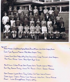
Photograph - School Photograph - Digital Image, Watsonia State School Wa4838 1968 Grade 3A, 1968_
... 1968 Grade 3A watsonia primary school watsonia state school ...A class photograph and caption of Watsonia State School 1968 Grade 3ADigital copy of a black and white class photograph with names written under photo. A word document with typed student names.watsonia primary school, watsonia state school -
 Greensborough Historical Society
Photograph - School Photograph - Digital Image, Watsonia State School Wa4838 1968 Grade 3B, 1968_
... 1968 Grade 3B watsonia primary school watsonia state school ...A class photograph and caption of Watsonia State School 1968 Grade 3BDigital copy of a black and white class photograph with names written under photo. A word document with typed student names.watsonia primary school, watsonia state school -
 Greensborough Historical Society
Photograph - School Photograph - Digital Image, Watsonia State School Wa4838 1968 Grade 3C, 1968_
... 1968 Grade 3C watsonia primary school watsonia state school ...A class photograph and caption of Watsonia State School 1968 Grade 3CDigital copy of a black and white class photograph with names written under photo. A word document with typed student names.watsonia primary school, watsonia state school -
 Greensborough Historical Society
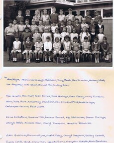
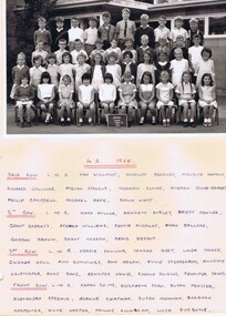
Photograph - School Photograph - Digital Image, Watsonia State School Wa4838 1968 Grade 4A, 1968_
... 1968 Grade 4A watsonia primary school watsonia state school ...A class photograph and caption of Watsonia State School 1968 Grade 4ADigital copy of a black and white class photograph with names written under photo. A word document with typed student names.watsonia primary school, watsonia state school -
 Greensborough Historical Society
Photograph - School Photograph - Digital Image, Watsonia State School Wa4838 1968 Grade 4B, 1968_
... 1968 Grade 4B watsonia primary school watsonia state school ...A class photograph and caption of Watsonia State School 1968 Grade 4BDigital copy of a black and white class photograph with names written under photo. A word document with typed student names.watsonia primary school, watsonia state school -
 Greensborough Historical Society
Photograph - School Photograph - Digital Image, Watsonia State School Wa4838 1968 Grade 4C, 1968_
... 1968 Grade 4C watsonia primary school watsonia state school ...A class photograph and caption of Watsonia State School 1968 Grade 4CDigital copy of a black and white class photograph with names written under photo. A word document with typed student names.watsonia primary school, watsonia state school -
 Greensborough Historical Society
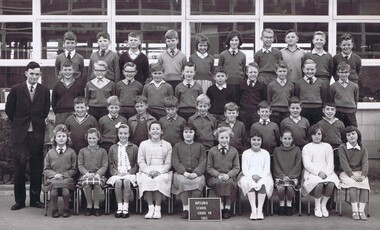
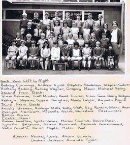
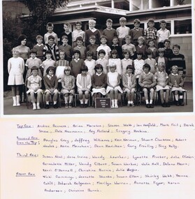
Photograph - School Photograph - Digital Image, Watsonia State School Wa4838 1968 Grade 5A, 1968_
... 1968 Grade 5A watsonia primary school watsonia state school ...A class photograph and caption of Watsonia State School 1968 Grade 5ADigital copy of a black and white class photograph with names written under photo. A word document with typed student names.watsonia primary school, watsonia state school -
 Greensborough Historical Society
Photograph - School Photograph - Digital Image, Watsonia State School Wa4838 1968 Grade 5B, 1968_
... 1968 Grade 5B watsonia primary school watsonia state school ...A class photograph and caption of Watsonia State School 1968 Grade 5BDigital copy of a black and white class photograph with names written under photo. A word document with typed student names.watsonia primary school, watsonia state school