Showing 609 items
matching river bank
-
 Dutch Australian Heritage Centre Victoria
Etching
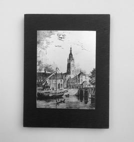
The Vliet is a canal in the western Netherlands, in the province of South Holland. It starts at the Oude Rijn at Leiden and joins the Delfshavense Schie canal at Delft. Places along its banks include Voorschoten, Leidschendam, Voorburg, The Hague and Rijswijk. The canal was dug in 47 AD under command of Roman general Corbulo, who wished to connect the river Rhine, of which the current Oude Rijn stream in Roman times was the main branch, to the Meuse estuary. It is unclear what the canal's trajectory was beyond the current city of Delft; the Delfshavense Schie canal, which connects Delft to the Nieuwe Maas river was not dug until 1389. In the Middle Ages the Vliet was an important trade link that attracted all kinds of trade, as it flowed through the heart of the County of Holland. Windmills have been constructed alongside the Vliet, including the completely renovated mill 'De salamander' in Leidschendam. The Vliet area was particularly attractive among richer families, who built their mansions along its banks.An historic small town scene etched (or possibly printed) on thin metal and subsequently fastened to a plywood backing. The delicately presented scene is said to show the intersection of Old Church Street and the Vliet Canal bridge in Voorburg, as well as a section of wharf. On the canal are one large and two much smaller vessels. A very tall crane-like construction arises from the wharf to the roof of waterside buildings. The people are soberly dressed in possibly 17th or 18th century costumes.On the reverse has been written: "Oude Kerkstraat Brug over de Vliet Voorburg". (Old Church Street; Bridge over the Vliet canal; Voorburg). However, research proves that the church is actually the Old Church in Delft, a short distance further down the Vliet Canal. -
 Clunes Museum
Memorabilia - NUMISMATICS, Stokes & Sons
... side depicts a pioneer on the south bank of the Yarra river... and the other side depicts a pioneer on the south bank of the Yarra ....1 White metal medal with a tricolour ribbon of red, white and blue. Attached to a ring connected to the medal. One side depicts the scene of landing at Portland in 1834 and the other side depicts a pioneer on the south bank of the Yarra river looking across Melbourne. On Reverse: Centenary of Victoria 1934 and Portland 1834 On Obverse: Centenary of Melbourne 1935 (AD)centenary of victoria 1934, centenary of melbourne 1935 -
 Clunes Museum
Artwork, other - LITHOGRAPH, Adelaide, From the River Torrens
Dark sepia scene, on linen surface paper. Depicting Torrens River, with bridge and city buildings in background. Tree lined banks, 2 figures on left bank and 3 rowing boats on river. 4 figures on right bank. Picture is mounted on 10mm thick chipboard which is coloured black.Scheil - A Irwin Sclithograph, torrens river -
Tatura Irrigation & Wartime Camps Museum
Book, Riverbanker Child a Personal Life
... The author grew up on the banks of the Goulburn river... Tatura the-murray The author grew up on the banks of the Goulburn ...The author grew up on the banks of the Goulburn river, where families lived in tents and shanties. His words and memories of growingt up as a Riverbanker in the 1940'sPart of the history of SheppartonSoft cover book, 52 pages, written by Alan H. Scott. White card cover front and back, Black pencil drawing on front of a tent with patches, a person in doorway, a dog . rear vover has a pencil drawing of a person leaning over a light. printing says Shepparton's Shanties, the Argus, Melbourne ,Vic 1848 -1954. Slum Boards Visit. 'Grievous Wrong being Done" plus other comments. The author has autographed page 1.Autographed by authorgoulburn river, shepparton -
Tatura Irrigation & Wartime Camps Museum
Photograph, 24/3/1917
Taken by photographer for State Rivers and Water Supply Commission.Medium sized black and white photograph. Sugarloaf Reservoir construction of core wall and tower / Rail trucks on single line bottom centre / Traction engine and pump in timber shed lower right / Horses and carts on bank beside upper dams/ words printed:"Upper Dam Core Wall , Bed Rock, Lower Dam."victorian state rivers and supply commission, sugarloaf reservoir -
Tatura Irrigation & Wartime Camps Museum
Photograph, 20/11/1956
Taken by photographer for State Rivers and Water Supply Commission.Medium sized black and white photograph. Big wash-away under concrete slab at Tatura Waterworks storage / upright posts bottom right corner / sandbags and petrol drum above water line left of centre / water left of bankvictorian state rivers and supply commission, tatura waterworks, tatura waterworks trust -
Tatura Irrigation & Wartime Camps Museum
Photograph, Alan Whiting, 1924
Taken for the Victorian State Rivers and Water Supply Commission.Mounted medium sized black and white photograph. Waranga Basin inlet structure / Concrete sides mid-upper picture / channel and basin water filled / rock filled bank left of pictureirrigation, victorian state rivers and water supply commission, waranga basin -
Tatura Irrigation & Wartime Camps Museum
Photograph, 1936/02
Photo taken by the photographer for Victoria State Rivers and Water Supply CommissionMedium sized black and white photograph. Eildon Reservoir spillway / Concrete structure centre / rock and earth fill dam wall top half / round concrete tower left midway along wall bank.goulburn, irrigation, photo, victoria state rivers and water supply commission, eildon, eildon weir -
Tatura Irrigation & Wartime Camps Museum
Photograph, Big Eildon Project, 1954
Taken by photographer for State Rivers and Water Supply Commission.Large sepia photograph. Terraced earthen bank forming wall of reservoir main feature - trees and several telegraph poles in foreground - gently rounded hills on horizon.Below photo: "BIG EILDON PROJECT / MAIN BANK FROM OBSERVATION POINT."victoria state rivers and water supply commission, eildon, eildon dam -
Tatura Irrigation & Wartime Camps Museum
Photograph, Goulburn Weir, 1890
Taken by photographer for State Rivers and Water Supply Commission.Medium sized black and white photograph. Earth and rubble bank bottom right corner - Concrete spillway and platform - overflow water in foreground - Trees on horizon - Dwelling left middle distancevictoria state rivers and water supply commission, goulburn weir -
Tatura Irrigation & Wartime Camps Museum
Photograph, Goulburn Weir, 1890
Taken by photographer for State Rivers and Water Supply Commission.Medium sized black and white photograph. View across weir - channel outlet left - earth and rubble wall separates two concrete and iron structures of weir. Trees on bank beyond beyond, buildings scattered amongst trees.victoria state rivers and water supply commission, goulburn weir -
Tatura Irrigation & Wartime Camps Museum
Photograph, Goulburn Weir, 1890
Taken by photographer for State Rivers and Water Supply Commission.Medium sized black and white photograph. Water flowing through opened weir gates - over spillway - weir structure mid-distance. Trees beyond on far bank.goulburn weir, victorian state rivers and supply commission -
Tatura Irrigation & Wartime Camps Museum
Photograph, Goulburn Weir, 1890
Taken by photographer for State Rivers and Water Supply Commission.Medium sized black and white photograph. Water teeming down spillway of concrete weir structure - concrete and iron walkway above. Trees on far bank beyond. Close up photographgoulburn weir, victorian state rivers and supply commission -
Tatura Irrigation & Wartime Camps Museum
Photograph, Goulburn Weir, 1890
Taken by photographer for State Rivers and Water Supply Commission.Medium sized black and white photograph. View of concrete and steel weir structure - with water cascading down the spillway steps from West side. Thick foliage beyond on East bankgoulburn weir, victorian state rivers and supply commission -
Tatura Irrigation & Wartime Camps Museum
Photograph, Goulburn Weir, 1890
Taken by photographer for State Rivers and Water Supply Commission.Medium sized black and white photograph. Newly completed diversion channel and weir looking north. Brick control building and two men on right - trees foreground and on East bank oppositegoulburn weir, victorian state rivers and supply commission -
Tatura Irrigation & Wartime Camps Museum
Photograph, Goulburn Weir, 1890
Taken by photographer for State Rivers and Water Supply Commission.Medium sized black and white photograph. Concrete and iron weir structure, stone spillway, earth bank on West bank below brick control house. Dead trees in water beyond weir, houses on West bankgoulburn weir, victorian state rivers and supply commission -
Tatura Irrigation & Wartime Camps Museum
Photograph, Goulburn Weir, 1890
Taken by photographer for State Rivers and Water Supply Commission.Medium sized black and white photograph. Concrete and iron weir structure - granite stone spillway with minor flow of water in centre. Close up photograph sparse trees on the bank beyond. Gas lamps on walkway.goulburn weir, victorian state rivers and supply commission -
Tatura Irrigation & Wartime Camps Museum
Photograph, 19/12/1946
Taken by photographer for State Rivers and Water Supply Commission.Medium sized black and white photograph. Waranga Reservoir main outlet - Western main channel looking downstream to Waranga. Concrete bridges and control structure join earthen banks of channel. Windmill mid-left of picture.goulburn weir, victorian state rivers and supply commission -
Tatura Irrigation & Wartime Camps Museum
Photograph, 1953
Taken by photographer for State Rivers and Water Supply Commission.Medium sized black and white photograph. Foreground - Theodolite / Two men / Rock Crusher / Tractor pulling To construct earth fill bank at cattanach canalgoulburn weir, victorian state rivers and supply commission -
Tatura Irrigation & Wartime Camps Museum
Photograph, 1954
Taken by photographer for State Rivers and Water Supply Commission.Medium sized black and white photograph. Workmen laying rock beaching material on the earth fill bank of the cattanach canalgoulburn weir, victorian state rivers and supply commission -
Tatura Irrigation & Wartime Camps Museum
Photograph, Gradall - Goulburn Valley Duplication Channel, 1957
Photograph of the creation of the Goulburn Waranga duplication channelLarge black and white photograph. Dry mounted to cream board. Channel bank formation. Gradall operated from tray of truck. Man observing operation from base of wall.Below photo - "Gradall Goulburn Waranga Duplication Channel"irrigation, channel, goulburn, victoria state rivers and water supply commission -
Tatura Irrigation & Wartime Camps Museum
Photograph, Goulburn Waranga No.2 Main Channel, 1957
Taken by the photographer for Victoria State Rivers and Water Supply Commission.Large sepia photograph dry mounted to cream board. Excavated channel with three levels - water in the lowest level, truck facing forward, second level, gang of workmen far distant on lowest level. Trees on horizon beyond top of bank.Below photo: "Goulburn-Waranga No.2 Channel"irrigation, channel, goulburn, waranga, victoria state rivers and water supply commission -
Tatura Irrigation & Wartime Camps Museum
Photograph, The Goulburn-Waranga Main Channel, 1957
Taken by the photographer for Victoria State Rivers and Water Supply Commission.Sepia photograph - dry mounted on cream cardboard. Wide view of water-filled channel, trees lining each bank Large photographAbove photo - "The Goulburn Waranga Main Channel"irrigation, goulburn, waranga, victoria state rivers and water supply commission, channel -
Tatura Irrigation & Wartime Camps Museum
Photograph, Cattanach Canal, 1957
Taken by the photographer for Victoria State Rivers and Water Supply Commission.Large sepia photograph - water filled channel inlet and bank - Man standing on platform looking down on concrete wall of measuring weir.Above photo: "Cattanach Canal / Inlet and Measuring Weir to Waranga Basin."irrigation, victoria state rivers and water supply commission, cattanach canal -
Tatura Irrigation & Wartime Camps Museum
Photograph, Cattanach Canal, 1957
Taken by the photographer for Victoria State Rivers and Water Supply Commission.Large sepia photograph - large stretch of water in foreground, men leaning down from platform above measuring weir in middle of photograph - trees on bank left and middle distance.Above photo: "Cattanach Canal / Inlet and Measuring Weir to Waranga Basin."irrigation, victoria state rivers and water supply commission, cattanach canal, waranga basin, measuring weir -
Tatura Irrigation & Wartime Camps Museum
Photograph, Wacker Rammer - Irrigation, 1957
Taken by photographer for State Rivers and Water Supply Commission.Medium sized black and white photo. Man using equipment(Wacker Rammer), to repair a channel break. Water foreground, Dethridge Wheel and concrete and earthen bank mid distance. Trees on horizon.On back: "A Wacker Rammer being used to repair a channel break."victoria state rivers and water supply commission, wacker rammer -
Tatura Irrigation & Wartime Camps Museum
Book, Yates Annual 1941, 1941
... On front cover photograph of colourful columbines on banks... of colourful columbines on banks of Derwent River Tasmania. On back ...On front cover photograph of colourful columbines on banks of Derwent River Tasmania. On back cover colour photograph of best six roses for 1941. Information about Yates seeds, plants and bulbs.yates garden catalogue, growing roses, growing annuals -
 Anglesea and District Historical Society
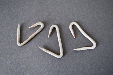
Bale Fasteners (3)
... Harold E. (Edward) Hurst (1888-1972) born on the banks...-1972) born on the banks of the Eumeralla River (near Macarthur ...Harold E. (Edward) Hurst (1888-1972) born on the banks of the Eumeralla River (near Macarthur) lived in a villa in Newtown called "Eumeralla" (Skene Street). "Boss" Hurst invented, patented and manufactured metal fasteners for wool bales and fencing. (Ref: 'Boss' Hurst of Geelong and Nauru : a life by Don Chambers) - held at the National Wool Museum, Geelong.Nonewool bale hooks, clips, fasteners, "grip bale fasteners", ev. hurst -
 Wangaratta RSL Sub Branch
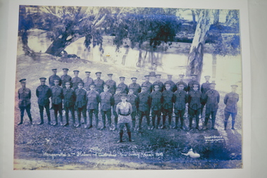
Photograph, 1916
... Photograph taken of 2nd Platoon on the banks of the Ovens... high-country Photograph taken of 2nd Platoon on the banks ...Photograph taken of 2nd Platoon on the banks of the Ovens River, Wangaratta. After completing training at Wangaratta they marched to the railway station headed by the Town Band prior to travelling to Broadmeadows Army Camp.Reproduction of black and white photograph of soldiers standing in two rows along riverbank lined with trees. There is a small white dog in foreground. Wangaratta's 2nd Platoon of Australia's New Army March 19161916, second platoon, wangaratta, ww1 -
 Robin Boyd Foundation
Document - Script, Robin Boyd, The Flying Dogtor. Episode 16 A Burn in the Blue, 1963
... The Flying Dogtor lying unconscious on the bank of a river after his... The Flying Dogtor lying unconscious on the bank of a river after his ...Elvis Eagle, the 'bodgie bird', saved the plane and found The Flying Dogtor lying unconscious on the bank of a river after his frightening trip down an underground tunnel. Meanwhile, back at the Hilltop Hospital, his nurse Sister Spaniel, was still trying to cope with a strange disease that had attacked the bush creatures. Little did she know what awful adventures had befallen The Flying Dogtor.The Flying Dogtor" series was broadcast on Australian Television Network (later becoming the Seven Network) between February and April 1964 (see item D254 for schedule).Typewritten, carbon copy, foolscap, 2 pagesPage 1: handwritten correctionthe flying dogtor, robin boyd, crawford productions, manuscript