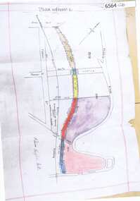
Showing 1857 items
matching road reserve
-
 Greensborough Historical Society
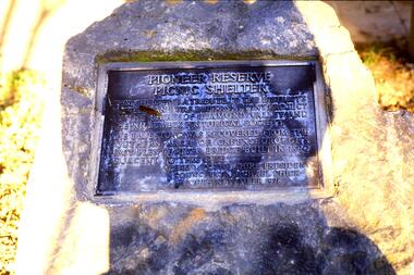
Slide - Photograph, John Ramsdale, Pioneer Reserve Picnic Shelter - Plaque: Slide 23, 1990s
Photograph shows Pioneer Reserve Picnic Shelter plaque.Part of the John Ramsdale collection of slides and audio visual material.Colour photograph scanned from slide.No maker's marks. No caption on slide.pioneer reserve greensborough, plaques -
 Greensborough Historical Society
Slide - Photograph, John Ramsdale, Pioneer Reserve plaque: Slide 26, 1990s
Photograph shows the Pioneer Reserve Park Plaque explaining that the bluestones came from the bridge over the Plenty River at Greensborough.Part of the John Ramsdale collection of slides and audio visual material.Colour photograph scanned from slide.No maker's marks. No caption on slide.plenty river, pioneer reserve greensborough, bluestone bridge greensborough -
 Greensborough Historical Society
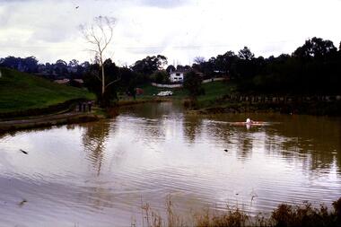
Slide - Photograph, John Ramsdale, Kalparrin Lake Greensborough: Slide 46, 1990s
Photograph shows Kalparrin Lake Greensborough with canoeist and white house in background.Part of the John Ramsdale collection of slides and audio visual material.Colour photograph scanned from slide.No maker's marks. No caption on slide.kalparrin reserve -
 Montmorency–Eltham RSL Sub Branch
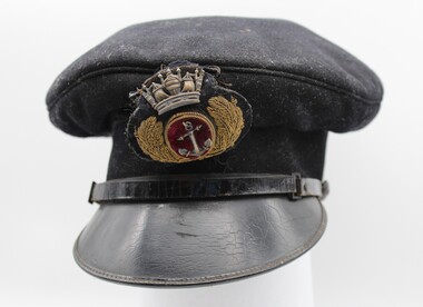
Uniform - Merchant Navy Cap
This merchant navy officer's cap has a black woollen felt hat band, black woollen felt fixed top cap and a black patent leather peak. Along the top of the peak there is a black patent strap. At the left hand of the peaked cap is a non-standard black plastic button and on the right side is a standard black cloth button. Above the peak there is a black wool badge of an Officer of the Merchant Navy. This insignia has a central, oval reserve of red velvet edged with gold metal coil with base metal anchor at the centre. The oval is surrounded by oak leaves of gold purl with stems of applied gold coil, and surrounded by a stamped base metal crown. The badge is backed with a wool blend fabric and attached to the top cat by brown cotton. Along the base of the hat band there is a bias hem. Inside the cap, the hat band is lined with hessian. Crimson silk is fixed to the top cap and hand stitched to the hessian as a lining to the cap.British merchant navy officer's cap insignia.merchant navy cap, british merchant navy -
 Montmorency–Eltham RSL Sub Branch
Headwear - Slouch hat, 1990
Standard issue hat to Army Reserve unit. Representative uniform itemKhaki Australian Army slouch hat (fur felt) with khaki cloth puggaree. Cloth black over red rectangular colour patch on right hand side of puggaree. Gilt metal Royal Victoria Regiment cap badge on front of puggaree. Australian Army rising sun badge on left side turned up brim. Brown vinyl sweat band. Chin strap missing. Hat mounted on plywood carrying board. Bardsley Hats 1990 broad arrow Fur felt 54 gold stencil on sweat band. "319232 READ R" handwritten inside sweatband "Sgt Nicholls" handwritten brown marker pen on mounting board slouch hat, australian army, australian army slouch hat, bardsley hats -
 Phillip Island and District Historical Society Inc.
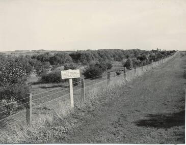
Photograph, Bryant West, 1959
One of a collection of over 400 photographs in an album commenced in 1960 and presented to the Phillip Island & Westernport Historical Society by the Shire of Phillip IslandPhotograph of Ventnor Reserve looking north along the wire netting fence fronting Ventnor Road and showing ornamental trees with young Manna Gums behind.Notice in foreground...Planted by Phillip Island Tree Planters Association assisted by Phillip Island School Children.local history, photography, photographs, ventnor reserve, manna gums, john jenner, bryant west -
 Greensborough Historical Society
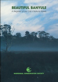
Book, Beautiful Banyule: by Carol Toomey, 1999_
A record of reserves and their features in the City of Banyule 1999. Full title: Beautiful Banyule: a register of out city's natural assets.A register of Banyule's natural assets104 pages, colour illustrations.Soft cover with treed skyline on front cover. 2 copies.Library labels.city of banyule, parks banyule, gardens banyule, historical sites banyule. -
 Greensborough Historical Society
Photograph - Digital Image, Marilyn Smith, E J Andrew Reserve, 16/01/2018
... Greensborough Historical Society 34A Glenauburn Road Lower ...The E J Andrew Reserve is situated in Railway Road Greensborough, near Sherbourne Road.Digital colour photographe j andrew reserve, briar hill -
 Greensborough Historical Society
Photograph - Digital Image, Marilyn Smith, Plantation Lane Briar Hill, 16/01/2018
Plantation Lane runs from Williams Street Greensborough, near Sherbourne Road, through the E J Andrew ReserveDigital colour photographe j andrew reserve, briar hill, plantation lane, williams street greensborough -
 Greensborough Historical Society
Map, Melbourne and Metropolitan Board of Works. Survey Division, MMBW, Yarra 2500 / 12.21. Watsonia North, 1979_02
Melbourne and Metropolitan Board of Works. Yarra 2500 [base map]. 12-22, Parish of Keelbundora 2856, Municipality of Diamond Valley 257. Shows street names, easement sizes, lot numbers, lodged plan numbers, names of prominent features, contour values, creek or river names. Watsonia Railway Station and environs. Prominent streets: Grimshaw Street, William Street and Macorna Street. Includes former Institute of Social Welfare (now Loyola College) Lines Reserve and Binnak Park.MMBW Map in 1:2500 [scale] series. Cream parchment with green tape reinforcing on edges and punched holes on left edge.mmbw, melbourne and metropolitan board of works, shire of diamond valley, watsonia - maps, bundoora - maps -
 Greensborough Historical Society
Map, Melbourne and Metropolitan Board of Works. Survey Division, MMBW, Yarra 2500 / 12.23. Janefield and Kangaroo Point, 1977_10
Melbourne and Metropolitan Board of Works. Yarra 2500 [base map] 12-23, Municipalities of Whittlesea 239 and Diamond Valley 257. No streets marked on this map. Includes Plenty River, Kangaroo Point, Janefield Colony and Janefield Reserve.MMBW Map in 1:2500 [scale] series. Cream parchment with green tape reinforcing on edges and punched holes on left edge.mmbw, melbourne and metropolitan board of works, shire of diamond valley, plenty - maps -
 Greensborough Historical Society
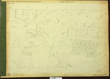
Map, Melbourne and Metropolitan Board of Works. Survey Division, MMBW, Yarra 2500 / 13.22. Greensborough, Apollo Parkways, 1979_06
Melbourne and Metropolitan Board of Works. Yarra 2500 [base map] 13-22. Greensborough, Apollo Parkways. Parishes of Nillumbik 3310 and Keelbundora 2856. Municipalities of Diamond Valley 257 and Whittlesea 239. Prominent streets include: Plenty River Drive, Diamond Creek Road and Civic Drive. Includes Diamond Valley Civi Centre, Churinga, Janefield Colony Reserve and "proposed freeway" now Greensborough Highway (Bypass)MMBW Map in 1:2500 [scale] series. Cream parchment with green tape reinforcing on edges and punched holes on left edge.mmbw, melbourne and metropolitan board of works, shire of diamond valley, greensborough - maps, apollo parkways - maps -
 Greensborough Historical Society
Map, Melbourne and Metropolitan Board of Works. Survey Division, MMBW, Yarra 2500 / 13.23. Plenty, Happy Hollow, 1979_03
Melbourne and Metropolitan Board of Works. Yarra 2500 [base map] 13-23. Plenty / Happy Hollow. Parishes of Morang 3183, Nillumbik 3310 and Keelbundora 2856. Municipalities of Diamond Valley 257 and Whittlesea 239. Prominent streets include: McLaughlans Lane and Happy Hollow Drive. Includes Janefield Colony Reserve.MMBW Map in 1:2500 [scale] series. Cream parchment with green tape reinforcing on edges and punched holes on left edge.mmbw, melbourne and metropolitan board of works, shire of diamond valley, plenty - maps, happy hollow -
 Greensborough Historical Society
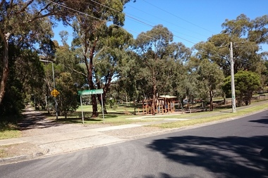
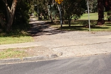
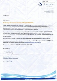
Letter, Restoring the natural beauty at Pioneer Reserve, 21/05/2019
Letter to residents, outlining plans to renovate Pioneer Reserve Greensborough by introducing native vegetation and returning it to a more natural state. This includes removing the toilets, picnic shelter and playground.2 p. letter, coloured aerial photograph on back pagepioneer reserve greensborough, banyule council -
 Greensborough Historical Society
Map, Heidelberg: Historic River Landscape Assessment. Historical maps. Map E 1901-1934 "A Time of projects and improvements", 1985c
Geographical area of around 35 sq. kilometres marked with physical features such as major roads, railways (new extension to Eltham), rivers and properties, also housing sub-divisions and community facilities such as hospitals, parks and sporting reserves and indications of new small scale industries such as dairying. Bounded by Shire of Diamond Valley to the North, Darebin Creek to the West and Plenty River to the East. Black and white sketch map on white paperheidelberg, heidelberg - maps -
 Greensborough Historical Society
Map, Poulter Avenue transverse, 1900 c
This is a survey of land acquired from William Haylock Poulter for the construction of Poulter Avenue. Includes area of River Estate and part of Poulter Reserve, Carter Street, Flintoff Street and Plenty River.1 p. photocopy of traverse survey printed in colourSigned by William Haylock Poulterpoutlter avenue greensborough -
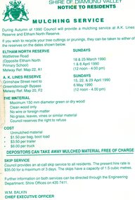 Greensborough Historical Society
Leaflet, Notice to residents: mulching service, Shire of Diamond Valley, 1990
Notice informing residents of a mulching service located at A. K. Lines Reserve and Eltham North Reserve on selected Sunday during March, April and May 19901 p. printed in green on off-white paper shire of diamond valley, mulching -
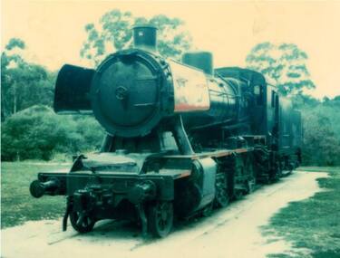 Greensborough Historical Society
Photograph - Digital Image, Steam train in Poulter Reserve, Greensborough, 1980s, 1980s
Photograph of retired steam train at Poulter Reserve Greensborough in the 1980s. This train was used as a playground attraction.Digital copy of colour photograph.greensborough railway station, trains, poulter reserve greensborough -
 Greensborough Historical Society
Photograph - Digital Image, Across Greensborough Station, 1973c, 1973c
Looking across Greensborough Station. Taken from Varalla's corner Para Road and Flintoff Street. Turning Pope's Paddock into the Poulter Reserve.Digital copy of black and white photograph. trains, greensborough station, popes paddock, poulter reserve greensborough -
 Greensborough Historical Society
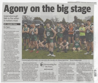
Newspaper Clipping, Diamond valley Leader, Agony on the big stage, 25/09/2019
Greensborough fails to fire when it matters most. The seniors and reserves sides had lost just one game between them before Saturday, with both enduring stunning upset defeats in their respective NFL Division 1 grand finals.News article 1 page, black text.northern football league, greensborough football club, west preston-lakeside football club -
 Greensborough Historical Society
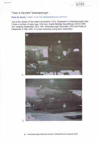
Article and Photograph, "Train in the Park" Greensborough, 2018_
Photographs and information relating to Greensborough's 'train in the park', steam locomotive J516, showing previous sites. Photos and information courtesy Paul de Sauty.This text and photographs were copied from a Facebook site. Members are people who lived in the Greensborough area and share their reminiscences of the area with others. The site is administered by a GHS member but is not officially affiliated with the Society. Any information is the opinion of the contributor. Photographs and text sourced from social media.steam trains, poulter reserve greensborough, greensborough station -
 Greensborough Historical Society
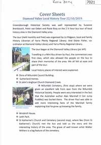
Booklet and article, Diamond Valley Local History Tour 2019, by Yarra Plenty Regional Library, 22/10/2019
Cover article written by Rosie Bray. In addition to YPRL booklets which have a brief history of each site visited, there are leaflets on Anglican parish of Diamond Creek; Nillumbik Cemetery; Ellis Cottage; Greensborough Cemetery and Sutherland Homes for ChildrenBooklet (2 copies) containing a brief history of sites visited on the Library's Diamond Valley Tour 2019, with 21 p. of supplementary information by various writers and 6 photographs taken on the tour.diamond valley, yarra plenty regional library, sutherland homes, st katherines church st helena, andrew yandell reserve, greensborough rsl, greensborough war memorial park, greensborough cemetery -
 Greensborough Historical Society
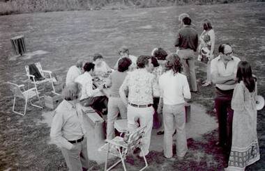
Photograph - Digital Image, Labor get together Poulter Avenue 1975/76, 1975c
A group of Labor supporters enjoy a get together at Poulter Avenue Reserve in Greensborough, 1975 or 1976. Photos are not named.Digital copy of black and white photographspoulter avenue greensborough, australian labor party -
 Greensborough Historical Society
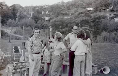
Photograph - Digital Image, Labor get together Poulter Avenue 1975/76, 1975c
A group of Labor supporters enjoy a get together at Poulter Avenue Reserve in Greensborough, 1975 or 1976. Photos are not named.Digital copy of black and white photographspoulter avenue greensborough, australian labor party -
 Greensborough Historical Society
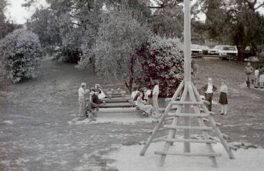
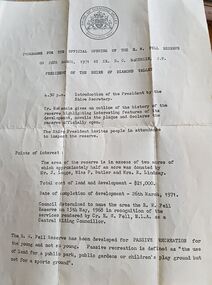
Program - Digital Image, Shire of Diamond Valley, Fell Reserve opening 1971, 26/03/1971
Program for the opening of the Fell Reserve on 26/03/1971. Named after Councillor R.W. Fell, MLA, for services rendered as a Central Riding councillor of the Shire of Diamond Valley. The Fell Reserve is located at 170 Grimshaw Street Greensborough. The playground at Fell Reserve is to be renovated in 2020.Digital copy of programr w fell reserve, shire of diamond valley, grimshaw street greensborough -
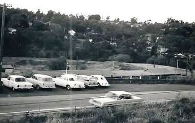
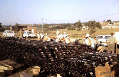 Greensborough Historical Society
Photograph - Digital Image, Watsonia Scouts Bottle Drive, 1970_
In the days before recycling on rubbish collection days, community groups could raise money through a 'bottle drive'. These photographs show on bottle drive in Watsonia to raise money for the Watsonia Scout Hall. The location is A. K. Lines Reserve - in the background is St Mary's Church, with few houses and no freeway.Digital copy of colour photographwatsonia scouts, bottle drives, a k lines reserve -
 Greensborough Historical Society
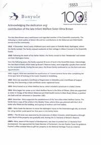
Article, Acknowledging the dedication and contribution of the late Infant Welfare Sister Alma Brown, 1916o
Chronology of Alama Brown's life, work in maternal and child health in the Diamond Valley area and conservation, memorialised by Brown's Reserve in Greenhills. Also a celebration of 100 years of Maternal and Child Health.4p. col. documents, photographsalma brown, infant welfare -
 Greensborough Historical Society
Map, Melbourne and Metropolitan Board of Works. Survey Division, MMBW, Yarra 2500 / 15.23. Diamond Creek Reserve, 1978_02
Melbourne and Metropolitan Board of Works. Yarra 2500 [base map] 15.23. Hurstbridge. Municipality of Diamond Valley 257. Prominent streets include: Challenger Street, James Cook Drive and Ryans Road / Main Street. Features include the Diamond Creek and Diamond Creek Reserve.MMBW Map in 1:2500 [scale] series. Cream parchment with green tape reinforcing on edges and punched holes on left edge.mmbw, melbourne and metropolitan board of works, shire of diamond valley, diamond creek - maps