Showing 357 items matching "rural development"
-
 Ringwood and District Historical Society
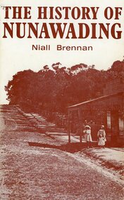
Book, Niall Brennan, The History of Nunawading, 1972
Sepia coloured dust cover on green hardcover book covering European settlement and development of Nunawading as a Parish, Rural Shire, and part of the City of Whitehorse. Loose A4 size typewritten page enclosed - My Country by Dorothea Mackellar. -
 Eltham District Historical Society Inc
Photograph - Digital Photograph, Alan King, Graves of Thomas Sweeney and family, Eltham Cemetery, Victoria, 27 January 2008
The grave of Thomas Sweeney, former convict turned respectable citizen. The Murray and Sweeney families were both early settlers of the Eltham district and connected by marriage. Their family plots are located side by side in the Catholic section of the Eltham Cemetery. Irish-born Thomas Sweeney is regarded as the first settler in Eltham. He was transported to Sydney in 1823 after being convicted of arson. He was granted his freedom in 1838 and married Margaret Meehan in the same year. They moved to Melbourne and in 1842 Thomas purchased 110 acres beside the Yarra River in the vicinity of present-day Sweeneys Lane. He called the property ‘Culla Hill’ and built a small slab hut (reputedly with Wurundjeri help; Margaret is said to have run an informal hospital for them in return). This was followed in 1846 by more substantial buildings consisting of a three-roomed Irish-style ‘longhouse’ and a barn made of stone and handmade bricks, with doors large enough to accommodate a fully loaded wagon. When the gold rush came, Thomas prospered by selling meat and potatoes to the prospectors, enabling him to purchase a further 308 acres in 1856. He promoted the construction of a bridge over the Plenty River and the establishment of a school at Eltham. Roman Catholic Church services were held at Culla Hill in the early years. When he died in 1867, he was regarded as a respected member of the community. Thomas and Margaret are buried in Eltham Cemetery with many of their descendants. Their first son John continued to farm Culla Hill until his death in 1909. Culla Hill passed out of the Sweeneys' possession in 1939. The house and barn remain today, though lesser outbuildings have gone. The facade of the house is much the same as it was in the 1840s. Sacred To the memory of Thomas Sweeney Who died Sep 6th 1867 Aged 65 years May his soul res in peace Also his wife Margaret Died Oct 3rd 1884 aged 73 years And their daughters Annie Died Aug 22nd 1860 aged 21 years Johanna Died Aug 19th 1872 aged 22 years Margaret Died 7th Sep 1913 aged 72 years R.I.P. Also In Memory Of John Sweeney Died 24th May 1909 Aged 65 years Also of his wife Ellen Died 8th March 1910 Aged 64 years R.I.P Also In Memory Of Caroline Infant daughter of John & Ellen Sweeney Published: Nillumbik Now and Then / Marguerite Marshall 2008; photographs Alan King with Marguerite Marshall.; p55 From the piety and poverty of 19th century Eltham, 20th century artists and environmentalists, to today’s comfortable middle class, Eltham Cemetery records it all — and more. A visit to Eltham Cemetery reveals an important social record since its beginnings in 1858. The cemetery was situated on about six acres (2.4ha) (now around 4.8ha) at the corner of Mount Pleasant and Metery Roads.1* It is thought that Metery Road was originally called Cemetery Road, but in the early 1940s, a resident, possibly a councillor, objected to the name resulting in the change.2 Much can be gleaned about the developing Eltham community from burial styles and the names of former local residents. Originally the cemetery was divided into Christian denominations, like others of that time, following the United Kingdom burial system. In 1861 the cemetery included Church of England, Presbyterian, Roman Catholic and Wesleyans (later Methodist) sites. Graves also indicated social class. Some had grand tombstones, perhaps fenced with ornamental cast iron railing, but most in the 1860s and 1870s were constructed of modest stone slabs.3 This indicated the poverty of the district, which was largely inhabited by farmers on small landholdings. A poignant reminder of the high rates of infant mortality of those times, are the many infants and young children recorded on the headstones. Major changes occurred in the cemetery in the late 20th century as Christian adherence weakened and society became more egalitarian and informal. In the early 1970s a non-denominational lawn section for burials was established. Since then all new areas have been non-denominational to accommodate the more diverse local community. Now, instead of large ornamental headstones, some mourners have chosen boulders, reflecting the natural Eltham style, while others choose graves in the lawn areas or niches in walls. In the late 1970s, the University Donor Section was established north-west of Candlebark Lawn for those who donated their bodies for The University of Melbourne medical research. In the early 1980s the natural Australian garden style, popular in Eltham, was mirrored in a new section called Ashes Walk. Local landscape architect Gordon Ford, who had popularised this style, designed the Walk using boulders shaded by native plants beside curved pathways. Landscape architect Robert Boyle later redesigned Ashes Walk and developed other parts of the cemetery in keeping with this style.4 Appropriately Ford, who died in 1999, was interred in the Native Garden Section in a cluster of sites shaded by a large eucalyptus tree.5 By 2007, about 6400 interments were recorded in the Eltham Cemetery. Close inspection reveals notable names in the district’s history. The grave of Thomas Sweeney, a former convict who became a respected citizen, can be found in the Roman Catholic section near the path. Eltham Primary School’s first headmaster, David Clark, is buried in a modest grave in the Church of England section to the east of the path from the main entrance. Sir William Irvine, Victorian Premier from 1900 to 1902, whose grave is in the north-east Presbyterian section was at various times Victoria’s Chief Justice, Deputy Governor and Treasurer.6 Further south is the grave of social reformer Bertram Wainer, born in Scotland in 1928 and died in 1987. He campaigned to legalise abortion and exposed police corruption in allowing illegal ‘backyard’ abortions. Other prominent local residents interred in the cemetery include: Justus Jörgensen, who founded Montsalvat; Alistair Knox, the mud-brick housing pioneer and Eltham Shire Councillor from 1971 to 1975 and President in 1975; Clem and Nina Christensen, who had a major influence on the literary development of post World War Two Australia. Others were: composer Dorian Le Gallienne; artist Peter Glass; Stephen Dattner, a prominent Melbourne furrier; ALP parliamentarian for Greensborough, Pauline Toner and political scientist and commentator, Professor William Macmahon Ball.This collection of almost 130 photos about places and people within the Shire of Nillumbik, an urban and rural municipality in Melbourne's north, contributes to an understanding of the history of the Shire. Published in 2008 immediately prior to the Black Saturday bushfires of February 7, 2009, it documents sites that were impacted, and in some cases destroyed by the fires. It includes photographs taken especially for the publication, creating a unique time capsule representing the Shire in the early 21st century. It remains the most recent comprehenesive publication devoted to the Shire's history connecting local residents to the past. nillumbik now and then (marshall-king) collection, annie sweeney, caroline sweeney, ellen sweeney, eltham cemetery, graves, gravestones, johanna sweeney, john murray, john sweeney, margaret sweeney, mary ellen drain, mary murray, thomas murray, thomas sweeney -
 Eltham District Historical Society Inc
Photograph - Digital Photograph, Alan King, Shillinglaw Cottage, 6 January 2008
Covered under National Estate, National Trust of Australia (Victoria) Local Significance and Heritage Overlay, Nillumbik Planning Scheme. Published: Nillumbik Now and Then / Marguerite Marshall 2008; photographs Alan King with Marguerite Marshall.; p95 Thanks to an Australia first effort by local residents, the historic Shillinglaw Cottage still survives. The cottage at Panther Place, Eltham, once stood about 100 metres away on Main Road. But in 1963 it faced demolition to make room for the Eltham Shire Offices (since demolished). However residents rallied to save Shillinglaw Cottage and became the first in Australia to remove and reconstruct an early settler’s brick building. A fundraiser was the residents’ compilation of loved recipes into the cookery book, Flavour of Eltham. The cottage, built in the late 1870s by noted pioneer builder George Stebbing, is one of Eltham’s earliest buildings and associated with significant early settlers. It is on the National Estate and National Trust Registers. The cottage was constructed with handmade bricks in the Flemish Bond style, typical of cottages and farmhouses in Flanders, Europe. It features burnt ‘header’ bricks over the façade, which gives a chequered effect. The roof is made of slate, while the windows are 12-paned sash with relieving arches. It is not clear who were the first owners of the cottage. The National Trust claims that Stebbing built it for farmer Thomas Cochrane.1 Others say Cochrane first owned the land but Stebbing was Shillinglaw’s first owner and remained so until 1887. The Shillinglaw family then bought it and lived there for around 80 years until 1963 when they sold it to the Eltham Council.2 Farmer Thomas Cochrane bought the Shillinglaw Cottage site from land developer Josiah Holloway. The site was the largest in what Holloway called Little Eltham, of some 30 acres (12 ha), extending along the creek from Henry Street to Luck Street. In 1874 Cochrane sold the land to George Stebbing. Meanwhile in 1861, Stebbing was the owner and occupier of a house at Pitt Street, Eltham, which he had built. Evelyn Observer journalist James Rossiter rented the Pitt Street house, then in 1881 Phillip Shillinglaw occupied it. Stebbing constructed several buildings of note in the area, including the Uniting Church at John Street, the building beside it – a former bank – and St Margaret’s Church of England in Pitt Street. Stebbing was also an Eltham Shire Councillor from 1871 to 1873 and a trustee and treasurer of the Eltham Wesleyan Church.3 In the 1870s he is recorded as the owner of up to five houses. Earlier he had been described as a bricklayer and later became a farmer. In 1882 Stebbing returned to the Pitt Street house and Shillinglaw occupied the new house in Main Road, which he owned from 1887. Shillinglaw was a prolific poet and preached at the Eltham Primitive Methodist Church, where he also served as Sunday School superintendent and led the Young People’s Society Christian Endeavour. The Shillinglaws saw many changes in their property’s boundaries – the major one occurring at the turn of the century when land for the railway and Eltham station was acquired from their holding. The northern part of the remaining land was then used for some of the first commercial developments in what was to become the Eltham Shopping Centre. Later still, the land immediately north of the cottage was bought by the Eltham War Memorial Trust for the War Memorial Buildings and the fire station. The Trust’s land eventually passed to the council. The council bought the remaining two acres (0.8 ha) with the house, and with the exception of the commercial development between the fire station and the post office, all of the former Shillinglaw land is owned by the council or government instrumentalities.4 Since the late 20th century, the cottage has had varied uses, such as a handcrafts store and as a restaurant.This collection of almost 130 photos about places and people within the Shire of Nillumbik, an urban and rural municipality in Melbourne's north, contributes to an understanding of the history of the Shire. Published in 2008 immediately prior to the Black Saturday bushfires of February 7, 2009, it documents sites that were impacted, and in some cases destroyed by the fires. It includes photographs taken especially for the publication, creating a unique time capsule representing the Shire in the early 21st century. It remains the most recent comprehenesive publication devoted to the Shire's history connecting local residents to the past. nillumbik now and then (marshall-king) collection, shillinglaw cottage -
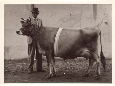
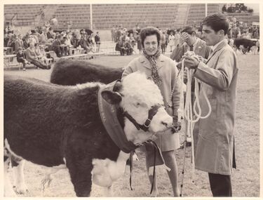
 Melbourne Royal
Photograph, Frank Johnson, 1954
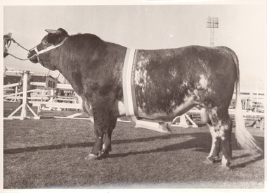
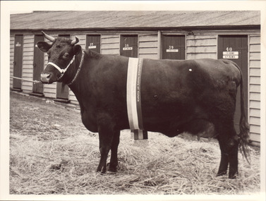
Champion Dairy Shorthorn Bull at the 1954 Royal Melbourne Show, Iford Cambridge Duke 7th, exhibited by Russell N. Stokes, Charlbury, WesburnThis item is a part of a larger collection of 4,500 Frank Johnson photographs and negatives donated to Melbourne Royal by Frank Johnson’s daughter, Francis Beatty Wallace in 2016. This collection spanning from the 1930s to the 1980s holds important social and historical significance in preserving and sharing Victoria’s agricultural history and community. The photographs capture the local, regional, and state’s shared relationships developed through agriculture and the importance of farming and husbandry to the population and development of Australia. A large proportion of these photographs depict events from the Royal Melbourne Show, including livestock competitions, exhibitions and awards ceremonies. Dating back to 1848 when the society first began, the Royal Melbourne Show has held a special place in the hearts and minds of Victorians, allowing for extensive showcasing and celebration of agricultural excellence, bridging the divide between metropolitan and rural Victoria.[paper taped to reverse, typed] Champion Dairy Shorthorn Bull. Iford Cambridge Duke 7th. Russell N Stokes Charlbury Wesburnroyal melbourne show, cattle, dairy cattle, stokes, russell stokes, agricultural shows, blue ribbon competitions, winners -
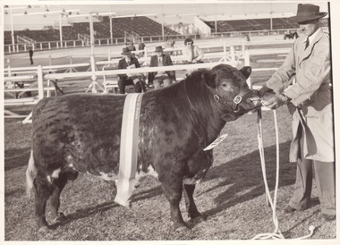
 Melbourne Royal
Photograph, Frank Johnson, 1954
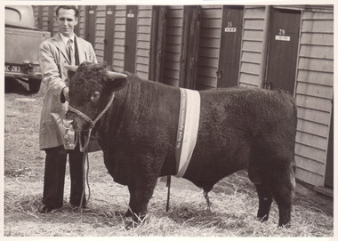
Black and white photograph of a Champion Devon BullThis item is a part of a larger collection of 4,500 Frank Johnson photographs and negatives donated to Melbourne Royal by Frank Johnson’s daughter, Francis Beatty Wallace in 2016. This collection spanning from the 1930s to the 1980s holds important social and historical significance in preserving and sharing Victoria’s agricultural history and community. The photographs capture the local, regional, and state’s shared relationships developed through agriculture and the importance of farming and husbandry to the population and development of Australia. A large proportion of these photographs depict events from the Royal Melbourne Show, including livestock competitions, exhibitions and awards ceremonies. Dating back to 1848 when the society first began, the Royal Melbourne Show has held a special place in the hearts and minds of Victorians, allowing for extensive showcasing and celebration of agricultural excellence, bridging the divide between metropolitan and rural Victoria.Champion Devon Bull. Tabletop Hero. Tabletop station Tabletop NSWroyal melbourne show -
 Melbourne Royal
Photograph, Frank Johnson, 1953
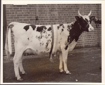
Black and white photograph of a black and white cow with horns. Champion sash from 1953This item is a part of a larger collection of 4,500 Frank Johnson photographs and negatives donated to Melbourne Royal by Frank Johnson’s daughter, Francis Beatty Wallace in 2016. This collection spanning from the 1930s to the 1980s holds important social and historical significance in preserving and sharing Victoria’s agricultural history and community. The photographs capture the local, regional, and state’s shared relationships developed through agriculture and the importance of farming and husbandry to the population and development of Australia. A large proportion of these photographs depict events from the Royal Melbourne Show, including livestock competitions, exhibitions and awards ceremonies. Dating back to 1848 when the society first began, the Royal Melbourne Show has held a special place in the hearts and minds of Victorians, allowing for extensive showcasing and celebration of agricultural excellence, bridging the divide between metropolitan and rural Victoria.A black and white photograph, landscape, printed on gloss paper with a white borderroyal melbourne show, cattle, cow, winners, blue ribbon competition, agricultural shows -
 Melbourne Royal
Photograph, Frank Johnson, 1954
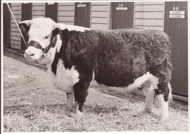
Black and white photograph of a Champion Hereford cowThis item is a part of a larger collection of 4,500 Frank Johnson photographs and negatives donated to Melbourne Royal by Frank Johnson’s daughter, Francis Beatty Wallace in 2016. This collection spanning from the 1930s to the 1980s holds important social and historical significance in preserving and sharing Victoria’s agricultural history and community. The photographs capture the local, regional, and state’s shared relationships developed through agriculture and the importance of farming and husbandry to the population and development of Australia. A large proportion of these photographs depict events from the Royal Melbourne Show, including livestock competitions, exhibitions and awards ceremonies. Dating back to 1848 when the society first began, the Royal Melbourne Show has held a special place in the hearts and minds of Victorians, allowing for extensive showcasing and celebration of agricultural excellence, bridging the divide between metropolitan and rural Victoria.Champion Jr and Res, Sr, Hereford cow. Coliban Best Girl 31st. RL McRachern Strathdownieroyal melbourne show, cattle, hereford, cow, winners, agricultural shows, blue ribbon competition, mcrachern, rl mcrachern -
 Melbourne Royal
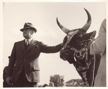
Photograph, Frank Johnson, 1954
Black and white photograph of a man standing with a long horned cow. The cow has a ribbon from the Royal Melbourne Coronation Show across its head, but it is unclear what colour (and therefore placing) it has received.This item is a part of a larger collection of 4,500 Frank Johnson photographs and negatives donated to Melbourne Royal by Frank Johnson’s daughter, Francis Beatty Wallace in 2016. This collection spanning from the 1930s to the 1980s holds important social and historical significance in preserving and sharing Victoria’s agricultural history and community. The photographs capture the local, regional, and state’s shared relationships developed through agriculture and the importance of farming and husbandry to the population and development of Australia. A large proportion of these photographs depict events from the Royal Melbourne Show, including livestock competitions, exhibitions and awards ceremonies. Dating back to 1848 when the society first began, the Royal Melbourne Show has held a special place in the hearts and minds of Victorians, allowing for extensive showcasing and celebration of agricultural excellence, bridging the divide between metropolitan and rural Victoria.A black and white photograph, landscape, printed on gloss paper with a white borderroyal melbourne show, cattle, cow, agricultural shows, blue ribbon competitions -
 Melbourne Royal
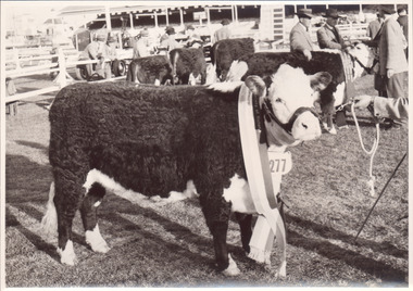
Photograph, Frank Johnson, 1954
Champion Poll Hereford Cow. The Brass Maple 17th. JA Hanson "The Braes" MacarthurThis item is a part of a larger collection of 4,500 Frank Johnson photographs and negatives donated to Melbourne Royal by Frank Johnson’s daughter, Francis Beatty Wallace in 2016. This collection spanning from the 1930s to the 1980s holds important social and historical significance in preserving and sharing Victoria’s agricultural history and community. The photographs capture the local, regional, and state’s shared relationships developed through agriculture and the importance of farming and husbandry to the population and development of Australia. A large proportion of these photographs depict events from the Royal Melbourne Show, including livestock competitions, exhibitions and awards ceremonies. Dating back to 1848 when the society first began, the Royal Melbourne Show has held a special place in the hearts and minds of Victorians, allowing for extensive showcasing and celebration of agricultural excellence, bridging the divide between metropolitan and rural Victoria.A black and white photograph, landscape, printed on gloss paper with a white borderChampion Poll Hereford Cow. The Brass Maple 17th. JA Hanson "The Braes" Macarthurroyal melbourne show, cattle, hereford, cow, winner, blue ribbon competition, agricultural shows, mcarthur, hanson, ja hanson -
 Melbourne Royal
Photograph, Frank Johnson, 1953
Black and white photograph of a Champion cow, possibly a shorthorn, 1953This item is a part of a larger collection of 4,500 Frank Johnson photographs and negatives donated to Melbourne Royal by Frank Johnson’s daughter, Francis Beatty Wallace in 2016. This collection spanning from the 1930s to the 1980s holds important social and historical significance in preserving and sharing Victoria’s agricultural history and community. The photographs capture the local, regional, and state’s shared relationships developed through agriculture and the importance of farming and husbandry to the population and development of Australia. A large proportion of these photographs depict events from the Royal Melbourne Show, including livestock competitions, exhibitions and awards ceremonies. Dating back to 1848 when the society first began, the Royal Melbourne Show has held a special place in the hearts and minds of Victorians, allowing for extensive showcasing and celebration of agricultural excellence, bridging the divide between metropolitan and rural Victoria.A black and white photograph, landscape, printed on gloss paper with a white borderroyal melbourne show, cattle, cow, blue ribbon competitions, agricultural shows, winners -
 Melbourne Royal
Photograph, Frank Johnson, 1953
Black and white photograph of a Champion shorthorn cow 1953This item is a part of a larger collection of 4,500 Frank Johnson photographs and negatives donated to Melbourne Royal by Frank Johnson’s daughter, Francis Beatty Wallace in 2016. This collection spanning from the 1930s to the 1980s holds important social and historical significance in preserving and sharing Victoria’s agricultural history and community. The photographs capture the local, regional, and state’s shared relationships developed through agriculture and the importance of farming and husbandry to the population and development of Australia. A large proportion of these photographs depict events from the Royal Melbourne Show, including livestock competitions, exhibitions and awards ceremonies. Dating back to 1848 when the society first began, the Royal Melbourne Show has held a special place in the hearts and minds of Victorians, allowing for extensive showcasing and celebration of agricultural excellence, bridging the divide between metropolitan and rural Victoria.A black and white photograph, landscape, printed on gloss paper with a white borderroyal melbourne show, shorthorn, cattle, cow, agricultural shows, winners, blue ribbon competitions -
 Melbourne Royal
Photograph, Frank Johnson, 1954
Black and white photograph of a Champion Friesian Bull Champion Friesian Bull. Glenhope Keystone Burkeyje. FJ Fox "Kingstone Park" Merricks NorthThis item is a part of a larger collection of 4,500 Frank Johnson photographs and negatives donated to Melbourne Royal by Frank Johnson’s daughter, Francis Beatty Wallace in 2016. This collection spanning from the 1930s to the 1980s holds important social and historical significance in preserving and sharing Victoria’s agricultural history and community. The photographs capture the local, regional, and state’s shared relationships developed through agriculture and the importance of farming and husbandry to the population and development of Australia. A large proportion of these photographs depict events from the Royal Melbourne Show, including livestock competitions, exhibitions and awards ceremonies. Dating back to 1848 when the society first began, the Royal Melbourne Show has held a special place in the hearts and minds of Victorians, allowing for extensive showcasing and celebration of agricultural excellence, bridging the divide between metropolitan and rural Victoria.A black and white photograph, landscape, printed on gloss paper with a white borderChampion Friesian Bull. Glenhope Keystone Burkeyje. FJ Fox "Kingstone Park" Merricks Northroyal melbourne show, friesian, bull, agricultural shows, blue ribbon competitions, winners, glenhope, kingstone, fj fox, fox -
 Melbourne Royal
Photograph, Frank Johnson, 1954
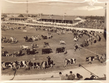
Grand Parades on the main arena were a popular Melbourne Royal Show attraction and tradition. The first was in 1910 - prior to this, horses and cattle had been paraded around the arena separately, but at this particular Show they were paraded together for the first time in a ‘Massed’ (Grand) Parade. This innovation proved very popular with exhibitors and the general public alike. The last Grand Parade was in 2004.This item is a part of a larger collection of 4,500 Frank Johnson photographs and negatives donated to Melbourne Royal by Frank Johnson’s daughter, Francis Beatty Wallace in 2016. This collection spanning from the 1930s to the 1980s holds important social and historical significance in preserving and sharing Victoria’s agricultural history and community. The photographs capture the local, regional, and state’s shared relationships developed through agriculture and the importance of farming and husbandry to the population and development of Australia. A large proportion of these photographs depict events from the Royal Melbourne Show, including livestock competitions, exhibitions and awards ceremonies. Dating back to 1848 when the society first began, the Royal Melbourne Show has held a special place in the hearts and minds of Victorians, allowing for extensive showcasing and celebration of agricultural excellence, bridging the divide between metropolitan and rural Victoria.A sepia photograph, landscape, printed on gloss paper with a white border.royal melbourne show, grand parade, cattle, horses, main arena, melbourne showgrounds, agricultural shows -
 Melbourne Royal
Photograph, Frank Johnson, 1954
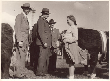
Black and white photograph of cattle judges speaking to a young girl leading a hereford bullThis item is a part of a larger collection of 4,500 Frank Johnson photographs and negatives donated to Melbourne Royal by Frank Johnson’s daughter, Francis Beatty Wallace in 2016. This collection spanning from the 1930s to the 1980s holds important social and historical significance in preserving and sharing Victoria’s agricultural history and community. The photographs capture the local, regional, and state’s shared relationships developed through agriculture and the importance of farming and husbandry to the population and development of Australia. A large proportion of these photographs depict events from the Royal Melbourne Show, including livestock competitions, exhibitions and awards ceremonies. Dating back to 1848 when the society first began, the Royal Melbourne Show has held a special place in the hearts and minds of Victorians, allowing for extensive showcasing and celebration of agricultural excellence, bridging the divide between metropolitan and rural Victoria.A black and white photograph, landscape, printed on gloss paper with a white borderroyal melbourne show, cattle, hereford, bull, kids at show, judging, agricultural shows, blue ribbon competitions -
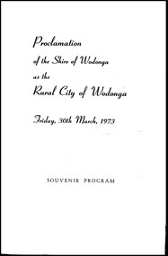 Wodonga & District Historical Society Inc
Programme - Proclamation of the Shire of Wodonga as a Rural City, 1973
This program from the ceremony proclaiming the Shire of Wodonga as a Rural City in 1973 documents the development of Wodonga as an important centre in North East Victoria. The decentralisation of industry and the establishment of international companies in Wodonga in the second half of the 20th century contributed to the growth of Wodonga as a major regional centre today.A small booklet of 4 pages stabled along the centre fold. The cover is printed on glossy light-weight card. It is printed in dark blue ink.This program from the ceremony proclaiming the Shire of Wodonga as a Rural City in 1973 documents the development of Wodonga as an important centre in North East Victoria. The decentralisation of industry and the establishment of international companies in Wodonga in the second half of the 20th century contributed to the growth of Wodonga as a major regional centre today.rural city of wodonga, wodonga council, proclamation wodonga -
 Melbourne Royal
Photograph, Frank Johnson, 1954
Black and white photograph of a Champion Jersey cow 1953This item is a part of a larger collection of 4,500 Frank Johnson photographs and negatives donated to Melbourne Royal by Frank Johnson’s daughter, Francis Beatty Wallace in 2016. This collection spanning from the 1930s to the 1980s holds important social and historical significance in preserving and sharing Victoria’s agricultural history and community. The photographs capture the local, regional, and state’s shared relationships developed through agriculture and the importance of farming and husbandry to the population and development of Australia. A large proportion of these photographs depict events from the Royal Melbourne Show, including livestock competitions, exhibitions and awards ceremonies. Dating back to 1848 when the society first began, the Royal Melbourne Show has held a special place in the hearts and minds of Victorians, allowing for extensive showcasing and celebration of agricultural excellence, bridging the divide between metropolitan and rural Victoria.A black and white photograph, landscape, printed on gloss paper with a white borderroyal melbourne show, jersey, cow, cattle, 1953 royal melbourne coronation show, blue ribbon competitions, winners, agricultural shows -
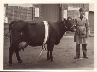
 Melbourne Royal
Photograph, Frank Johnson, 1953
A Champion bull (small) 1953This item is a part of a larger collection of 4,500 Frank Johnson photographs and negatives donated to Melbourne Royal by Frank Johnson’s daughter, Francis Beatty Wallace in 2016. This collection spanning from the 1930s to the 1980s holds important social and historical significance in preserving and sharing Victoria’s agricultural history and community. The photographs capture the local, regional, and state’s shared relationships developed through agriculture and the importance of farming and husbandry to the population and development of Australia. A large proportion of these photographs depict events from the Royal Melbourne Show, including livestock competitions, exhibitions and awards ceremonies. Dating back to 1848 when the society first began, the Royal Melbourne Show has held a special place in the hearts and minds of Victorians, allowing for extensive showcasing and celebration of agricultural excellence, bridging the divide between metropolitan and rural Victoria.A black and white photograph, landscape, printed on gloss paper with a white border[on bull's neck number] 138royal melbourne show, bull, cattle, blue ribbon competitions, agricultural shows -
 Melbourne Royal
Photograph, Frank Johnson, 1954
Black and white photograph of a hereford bullThis item is a part of a larger collection of 4,500 Frank Johnson photographs and negatives donated to Melbourne Royal by Frank Johnson’s daughter, Francis Beatty Wallace in 2016. This collection spanning from the 1930s to the 1980s holds important social and historical significance in preserving and sharing Victoria’s agricultural history and community. The photographs capture the local, regional, and state’s shared relationships developed through agriculture and the importance of farming and husbandry to the population and development of Australia. A large proportion of these photographs depict events from the Royal Melbourne Show, including livestock competitions, exhibitions and awards ceremonies. Dating back to 1848 when the society first began, the Royal Melbourne Show has held a special place in the hearts and minds of Victorians, allowing for extensive showcasing and celebration of agricultural excellence, bridging the divide between metropolitan and rural Victoria.A black and white photograph, landscape, printed on gloss paper with a white borderroyal melbourne show, hereford, bull, agricultural shows, blue ribbon competitions -
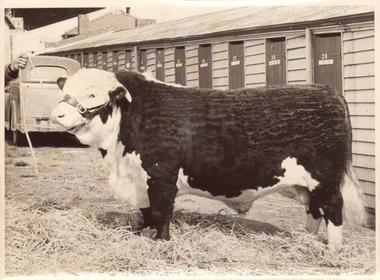
 Melbourne Royal
Photograph, Frank Johnson, 1954
Black and white photograph of a poll Hereford bulls lined up for judgingThis item is a part of a larger collection of 4,500 Frank Johnson photographs and negatives donated to Melbourne Royal by Frank Johnson’s daughter, Francis Beatty Wallace in 2016. This collection spanning from the 1930s to the 1980s holds important social and historical significance in preserving and sharing Victoria’s agricultural history and community. The photographs capture the local, regional, and state’s shared relationships developed through agriculture and the importance of farming and husbandry to the population and development of Australia. A large proportion of these photographs depict events from the Royal Melbourne Show, including livestock competitions, exhibitions and awards ceremonies. Dating back to 1848 when the society first began, the Royal Melbourne Show has held a special place in the hearts and minds of Victorians, allowing for extensive showcasing and celebration of agricultural excellence, bridging the divide between metropolitan and rural Victoria.A black and white photograph, landscape, printed on gloss paper with a white border[printed and taped on the reverse] Poll Hereford line up for Ch. Bullroyal melbourne show, hereford, bull, cattle, livestock, blue ribbon competitions, agricultural shows, judging -
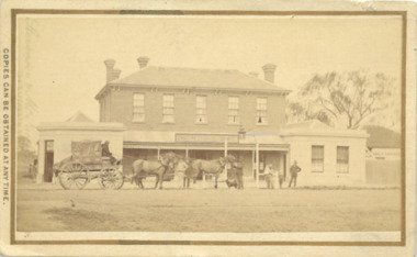 Bacchus Marsh & District Historical Society
Photograph, Border Inn, Main Street Bacchus Marsh 1883
The Border Inn located on the corner of Main Street and Graham Street Bacchus Marsh opened in 1851 making it a very early hotel in Victoria. It was built and owned by John Pilmer. The first licensee was James Watt. The building has been added to and changed many times. It was originally a single storey building. A second storey was added in 1863 by John Pilmer. In 1866 the hotel was purchased by Edward Jones. The Jones family owned and operated the hotel until 1939. Additional second storey sections were added in 1883, 1904 and 1936. For a number of years the Border Inn was a stopping post for coaching services between Melbourne and Ballarat. The first licensee of the hotel James Watt was among the first in Victoria to offer a regular coaching service and his hotel was used for overnight accommodation by coach travellers. At the time this picture was taken coach services were still operating between Bacchus Marsh and other locations. The coach in this picture is possibly one of those coaches.This building has been documented as of state significance by Richard Peterson and Daniel Catrice in their 1995 heritage study for the then Shire of Bacchus Marsh. Their assessment of the heritage significance of the building was: "The Border Inn is of state historical significance as a pioneering pre-gold rush building, on the route to the Ballarat goldfields. It is the representative-embodiment of several historical periods and their way of life. It demonstrates a complex changing sequence of patterns of occupancy and architectural styles. Its development at this location, demonstrates the effect of a social movement, the gold rush, as a transport stopover.It is also historically significant for its association with the first rural public transport in Victoria. Locally, the hotel is significance for its association with the first meeting of municipal government, and also for its social significance as a traditional community, visitor focus and meeting place".Small sepia unframed photograph on card with gold border framing photograph. Housed in the album, 'Photographs of Bacchus Marsh and District in 1883 by Stevenson and McNicoll'. The image shows the Border Inn Hotel at an angle depicting the front of the building facing directly to the camera. It is a two storey brick building, with one-story additions at either end. Five chimneys can be seen extending from the building. The bottom storey has a verandah extending onto the footpath. A covered wagon, probably a coach, with four horses in harness is in front of the building. There are several people in the image. Two people are sitting on the driver’s seat of the wagon. Another man is standing holding the reins of the horses. At his feet is a dog. Behind them are two male adults. One is holding a small child. A young boy stands beside him.On the front: Stevenson & McNicoll. Photo. 108 Elizabeth St. Melbourne. COPIES CAN BE OBTAINED AT ANY TIME. On the back: LIGHT & TRUTH inscribed on a banner surmounted by a representation of the rising sun. Copies of this Portrait can be had at any time by sending the Name and Post Office Money Order or Stamps for the amount of order to STEVENSON & McNICOLL LATE BENSON & STEVENSON, Photographers. 108 Elizabeth Street, MELBOURNE. stevenson and mcnicoll 1883 photographs of bacchus marsh and district, hotels bacchus marsh, border inn hotel bacchus marsh, carriages and coaches, stagecoaches, james watt bacchus marsh, john pilmer bacchus marsh, edward jones family bacchus marsh -
 Melbourne Royal
Photograph, Frank Johnson, 1969
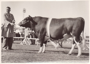
This photograph shows the Champion Poll Hereford Bull at the 1969 Royal Melbourne Show. The animal is exhibit 536, Springfield Hiawatha, exhibited by S, K & C Hawkins. The people in the photograph are Thea Manson and Terry Ryan, who was stud-groom at Springfield Poll Herefords in Finley NSW.This item is a part of a larger collection of 4,500 Frank Johnson photographs and negatives donated to Melbourne Royal by Frank Johnson’s daughter, Francis Beatty Wallace in 2016. This collection spanning from the 1930s to the 1980s holds important social and historical significance in preserving and sharing Victoria’s agricultural history and community. The photographs capture the local, regional, and state’s shared relationships developed through agriculture and the importance of farming and husbandry to the population and development of Australia. A large proportion of these photographs depict events from the Royal Melbourne Show, including livestock competitions, exhibitions and awards ceremonies. Dating back to 1848 when the society first began, the Royal Melbourne Show has held a special place in the hearts and minds of Victorians, allowing for extensive showcasing and celebration of agricultural excellence, bridging the divide between metropolitan and rural Victoria.A black and white, landscape photograph printed on card.royal melbourne show, manson, thea manson, ryan, terry ryan, springfield poll hereford, poll hereford, hereford, cattle, beef cattle, bull, livestock, blue ribbon competition, beef cattle competition, agricultural show, champion, grand champion, grand champion bull, winners, 1969 royal melbourne show -
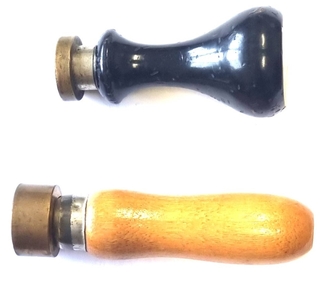 Wodonga & District Historical Society Inc
Functional object - Wodonga Council Official Seals
Wodonga Shire was created in 1876 when the colonial government agreed to ratepayers' petitions to have their part of the local government district severed from the Yackandandah Shire to form a new municipality. In March 1973 Wodonga was declared as the first Rural City in Australia. This was officially proclaimed by the Governor of Victoria, Sir Rohan Delacombe at an open-air ceremony in Hovell Street following a procession along High Street led by the Victorian Police Band. The first meeting of the Council was held in the open air immediately after the Proclamation.These Seals are significant because they document different stages in the development of local government in Wodonga.Two wood and metal seals to endorse documents. The seal with black painted handle is for the Rural City of Wodonga. The brown handled seal is for the Shire of WodongaSeal 1 - Rural City of Wodongawodonga shire council, rural city of wodonga -
 City of Greater Bendigo - Civic Collection
Artwork, other - Bendigo Pottery Toby Jug, Bendigo Pottery, Ned Kelly, c 1977
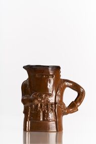
Established by George Guthrie in 1857 (about 5km north of its current site) and then again seven years later in 1864 after it initially closed, Bendigo Pottery remains one of the most influential and longest running Pottery’s in Australia. Over the years the Pottery has contributed to the growth and development of the district through both its products including building products, table ware and decorative and commemorative war as well as artistically, being responsible for training and supporting many potters locally. The City of Greater Bendigo has had a long history of partnering with Bendigo Pottery and the Civic Collection holds a number of important items within its collection. Ned Kelly is one of Australia's most iconic outlaws. Kelly was born and raised in rural Victoria, the third of eight children to Irish parents. His father, a transported convict, died in 1866, leaving Kelly, then aged 12, as the eldest male of the household. The Kelly's were a poor selector family who saw themselves as downtrodden by the squattocracy and as victims of persecution by the Victoria Police. While a teenager, Kelly was arrested for associating with bushranger Harry Power and served two prison terms for a variety of offences, the longest stretch being from 1871 to 1874. He later joined the "Greta Mob", a group of bush larrikins known for stock theft. A violent confrontation with a policeman occurred at the Kelly family's home in 1878, and Kelly was indicted for his attempted murder. Fleeing to the bush, Kelly vowed to avenge his mother, who was imprisoned for her role in the incident. After he, his brother Dan, and associates Joe Byrne and Steve Hart shot dead three policemen, the government of Victoria proclaimed them outlaws. Kelly died aged 25 at Melbourne Goal after being captured by Police in Glenrowan and sentenced to death. (Source Wikipedia).Brown glazed slip cast jug. Includes details which are iconic to the image of Ned Kelly including face and body armour pistol and gloves. Ned's left arm forms the handle.Verso; NED KELLY / Bendigo Pottery Epsom (stamp) Underside; Bendigo Pottery / Limited / Edition Series / 879 / 3000 / Australiacity of greater bendigo tourism, bendigo pottery -
 Bendigo Historical Society Inc.
Document - Michele Matthews collection - paperwork and reports for re-zoning of Maiden Gully (1993 - 1996). Residents opposed the re-zoning as they had purchased land as "bush blocks", 25/02/2025
documents for Maiden Gully Sewerage SchemeMichele Matthews collection - paperwork and reports for re-zoning of Maiden Gully (1993 - 1996). Residents opposed the re-zoning as they had purchased land as "bush blocks" Coliban water Annual report 1993/94 21/12/1994 Maiden Gully Development Committee - newsletter No 1 - cttee met with representatives of Coliban Water Caliban Water information Bulletin January 1995 - Maiden Gully Sewerage Scheme 22/02/1995 Maiden Gully Development Committee - newsletter No 2 - cttee activities re the planned sewerage scheme 27/03/1995 - Coliban Water letter to WR & MS Matthews, owners 3 Clay Gully Court (Lot 56 LP 212245) undated - Maiden Gully Neighborhood Sewerage Schemes - Robin Hill Estate Scheme (cost allocation to property owners 21/04/1995 five-page letter of objection/complaint from WR & MS Matthews, owners 3 Clay Gully Court, re costs allocated against their property (Lot 56 LP 212245) 16/06/1995 five-page response from Coliban Water to WR & MS Matthews, owners 3 Clay Gully Court; regarding the outcome of their objection to the sewerage scheme 22/08/1995 letter from WR & MS Matthews, to resident re the results of their objections (and consequent concessions) from Coliban Water re the Robin Hill Estate Sept 1995 Maiden Gully Structure Plan, prepared by TEA planners & Planning Australia Consultants; provides a structure plan, for the Rural City of Marong, the propose future development of the Maiden Gully area Greater Bendigo Planning Scheme - Amendment L43 - Maiden Gully Township: * undated and author unstated - Maiden Gully questions sheet for residents re the proposed Maiden Gully Structure Plan - seven questions and answers * Fauna species - observed /recorded site 6; Maiden Gully (off Pioneer drive) * Explanatory report, three pages * 1/11/1995 Notice of Amendment to a Planning Scheme * Greater Bendigo Planning Scheme, Chapter 6, Amendment L43 (five pages) December 1995 Coliban Water "In the Pipe line", Maiden Gully Region Community Newsletter No 2 - Halfway mark for Sewerage Scheme March 1996 Coliban Water "In the Pipe line", Maiden Gully Region Community Newsletter No 3 - Home stretch for new sewer scheme May 1996 Coliban Water "In the Pipe line", Maiden Gully Region Community Newsletter No 4 - New sewerage scheme comes in well under budget Undated - Maiden Gully Township - Amendment L43 - Panel Hearing report (31 pages) maiden gully, sewerage scheme -
 Whitehorse Historical Society Inc.
Article - National Trust of Australia (Victoria) Magazine, National Trust of Australia, Boongarry Avenue, Blackburn, Autumn 2023???
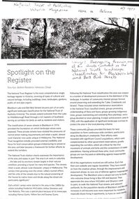
A photocopy of an article from the Victorian National Trust magazine pertaining to the inclusion of Boongarry Avenue for landscape classification within the Blackburn Lake and Bell Bird Streets, Blackburn.A photocopy of an article from the Victorian National Trust magazine pertaining to the inclusion of Boongarry Avenue for landscape classification within the Blackburn Lake and Bell Bird Streets, Blackburn.non-fictionA photocopy of an article from the Victorian National Trust magazine pertaining to the inclusion of Boongarry Avenue for landscape classification within the Blackburn Lake and Bell Bird Streets, Blackburn.boongarry avenue blackburn, blackburn lake, national trust of australia victoria -
 Narre Warren and District Family History Group
Book, Dot Morrison, 100 years in Skye 1850-1950, 2004
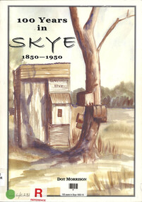
The book 100 Years in Skye, 1850-1950 by Dot Morrison explores the history of Skye in a detailed account of the area's development over a century, including its social, economic, and cultural changes. The book's illustrations, maps, and photographs offer a vivid portrayal of life in Skye during this period. Includes an index and bibliography.99 p.; 29 cmnon-fictionThe book 100 Years in Skye, 1850-1950 by Dot Morrison explores the history of Skye in a detailed account of the area's development over a century, including its social, economic, and cultural changes. The book's illustrations, maps, and photographs offer a vivid portrayal of life in Skye during this period. Includes an index and bibliography.skye (vic.), skye (vic.) -- history, skye (vic.) -- road names, wedge family, skye (vic.) -- murders, south lyndhurst state school -
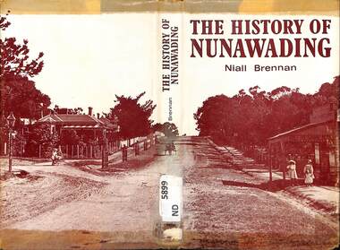 Whitehorse Historical Society Inc.
Book - Historical Resource, Niall Brennan, The History of Nunawading, 1972
This book covers the civic and industrial development of the shire of Nunawading since the first overlanders in 1830's. It includes photographs, maps, a bibliography and an index.This book covers the civic and industrial development of the shire of Nunawading since the first overlanders in 1830's. It includes photographs, maps, a bibliography and an index.non-fictionThis book covers the civic and industrial development of the shire of Nunawading since the first overlanders in 1830's. It includes photographs, maps, a bibliography and an index.shire of nunawading, blackburn, vermont, mitcham, nunawading