Showing 1516 items
matching sand
-
 Flagstaff Hill Maritime Museum and Village
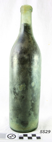
Bottle
Ref: LA 4 44 283 HISTORY OF THE LOCH ARD The LOCH ARD belonged to the famous Loch Line which sailed many ships from England to Australia. Built in Glasgow by Barclay, Curdle and Co. in 1873, the LOCH ARD was a three-masted square rigged iron sailing ship. The ship measured 262ft 7" (79.87m) in length, 38ft (11.58m) in width, 23ft (7m) in depth and had a gross tonnage of 1693 tons. The LOCH ARD's main mast measured a massive 150ft (45.7m) in height. LOCH ARD made three trips to Australia and one trip to Calcutta before its final voyage. LOCH ARD left England on March 2, 1878, under the command of Captain Gibbs, a newly married, 29 year old. She was bound for Melbourne with a crew of 37, plus 17 passengers and a load of cargo. The general cargo reflected the affluence of Melbourne at the time. On board were straw hats, umbrella, perfumes, clay pipes, pianos, clocks, confectionary, linen and candles, as well as a heavier load of railway irons, cement, lead and copper. There were items included that intended for display in the Melbourne International Exhibition in 1880. The voyage to Port Phillip was long but uneventful. At 3am on June 1, 1878, Captain Gibbs was expecting to see land and the passengers were becoming excited as they prepared to view their new homeland in the early morning. But LOCH ARD was running into a fog which greatly reduced visibility. Captain Gibbs was becoming anxious as there was no sign of land or the Cape Otway lighthouse. At 4am the fog lifted. A man aloft announced that he could see breakers. The sheer cliffs of Victoria's west coast came into view, and Captain Gibbs realised that the ship was much closer to them than expected. He ordered as much sail to be set as time would permit and then attempted to steer the vessel out to sea. On coming head on into the wind, the ship lost momentum, the sails fell limp and LOCH ARD's bow swung back. Gibbs then ordered the anchors to be released in an attempt to hold its position. The anchors sank some 50 fathoms - but did not hold. By this time LOCH ARD was among the breakers and the tall cliffs of Mutton Bird Island rose behind the ship. Just half a mile from the coast, the ship's bow was suddenly pulled around by the anchor. The captain tried to tack out to sea, but the ship struck a reef at the base of Mutton Bird Island, near Port Campbell. Waves broke over the ship and the top deck was loosened from the hull. The masts and rigging came crashing down knocking passengers and crew overboard. When a lifeboat was finally launched, it crashed into the side of LOCH ARD and capsized. Tom Pearce, who had launched the boat, managed to cling to its overturned hull and shelter beneath it. He drifted out to sea and then on the flood tide came into what is now known as LOCH ARD Gorge. He swam to shore, bruised and dazed, and found a cave in which to shelter. Some of the crew stayed below deck to shelter from the falling rigging but drowned when the ship slipped off the reef into deeper water. Eva Carmichael had raced onto deck to find out what was happening only to be confronted by towering cliffs looming above the stricken ship. In all the chaos, Captain Gibbs grabbed Eva and said, "If you are saved Eva, let my dear wife know that I died like a sailor". That was the last Eva Carmichael saw of the captain. She was swept off the ship by a huge wave. Eva saw Tom Pearce on a small rocky beach and yelled to attract his attention. He dived in and swam to the exhausted woman and dragged her to shore. He took her to the cave and broke open case of brandy which had washed up on the beach. He opened a bottle to revive the unconscious woman. A few hours later Tom scaled a cliff in search of help. He followed hoof prints and came by chance upon two men from nearby Glenample Station three and a half miles away. In a state of exhaustion, he told the men of the tragedy. Tom returned to the gorge while the two men rode back to the station to get help. By the time they reached LOCH ARD Gorge, it was cold and dark. The two shipwreck survivors were taken to Glenample Station to recover. Eva stayed at the station for six weeks before returning to Ireland, this time by steamship. In Melbourne, Tom Pearce received a hero's welcome. He was presented with the first gold medal of the Royal Humane Society of Victoria and a £1000 cheque from the Victorian Government. Concerts were performed to honour the young man's bravery and to raise money for those who lost family in the LOCH ARD disaster. Of the 54 crew members and passengers on board, only two survived: the apprentice, Tom Pearce and the young woman passenger, Eva Carmichael, who lost all of her family in the tragedy. Ten days after the LOCH ARD tragedy, salvage rights to the wreck were sold at auction for £2,120. Cargo valued at £3,000 was salvaged and placed on the beach, but most washed back into the sea when another storm developed. The wreck of LOCH ARD still lies at the base of Mutton Bird Island. Much of the cargo has now been salvaged and some was washed up into what is now known as LOCH ARD Gorge. Cargo and artefacts have also been illegally salvaged over many years before protective legislation was introduced. One of the most unlikely pieces of cargo to have survived the shipwreck was a Minton porcelain peacock - one of only nine in the world. The peacock was destined for the Melbourne International Exhibition in 1880. It had been well packed, which gave it adequate protection during the violent storm. Today, the Minton peacock can be seen at the Flagstaff Hill Maritime Museum in Warrnambool. From Australia's most dramatic shipwreck it has now become Australia's most valuable shipwreck artefact and is one of very few 'objects' on the Victorian State Heritage Register. Flagstaff Hill’s collection of artefacts from LOCH ARD is significant for being one of the largest collections of artefacts from this shipwreck in Victoria. It is significant for its association with the shipwreck, which is on the Victorian Heritage Register (VHR S417). The collection is significant because of the relationship between the objects, as together they have a high potential to interpret the story of the LOCH ARD. The LOCH ARD collection is archaeologically significant as the remains of a large international passenger and cargo ship. The LOCH ARD collection is historically significant for representing aspects of Victoria’s shipping history and its potential to interpret sub-theme 1.5 of Victoria’s Framework of Historical Themes (living with natural processes). The collection is also historically significant for its association with the LOCH ARD, which was one of the worst and best known shipwrecks in Victoria’s history. Glass bottle, light green, bottle is intact with slight chip on lip. Bottle has cork and some sand inside. Recovered from the wreck of the Loch Ard. Artefact Reg No LA/43.flagstaff hill, warrnambool, shipwrecked coast, flagstaff hill maritime museum, maritime museum, shipwreck coast, flagstaff hill maritime village, great ocean road, loch line, loch ard, captain gibbs, eva carmichael, tom pearce, glenample station, mutton bird island, loch ard gorge, bottle -
 Bendigo Military Museum
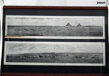
Photograph - PHOTOGRAPH WW1, FRAMED, c.1914-15
The two images were part of a book called, The All Australian Memorial as part of a fold out section. the two pages were lose in the book.Large timber frame, mid brown colour, dark green mount with glass. 2 black &white panoramic photos of the 1st Australian Division, Egypt. Camp scenes with tents, pyramids & sand.Below photos in black ink: "The 1st Australian Division, Australian Imperial Force - Egypt, 1914-15" Handwritten in black felt tip pen: "Property Bendigo RSL Museum, Peter Ball"photography-photographs, military history - army, eygpt pyramids, 1st australian division -
 Clunes Museum
Sculpture - CHEMIST AT WORK, A. HEAP
A FAREWELL PRESENT TO JIM KERIN LEAVING THE CLUNES PHARMACY IN 2000SAND CLAY MODEL OF A CHEMIST AT WORK. BENCH WITH "CLUNES PHARMACY" ON FRONT. CHEMIST STANDING BEHIND COUNTER WORKING WITH MORTAR AND PESTEL, OPEN BOOK ON HIS RIGHT, PHARMACEUTICAL CONTAINERS ON HIS RIGHTpharmacy, chemist, sculpture -
 Southern Sherbrooke Historical Society Inc.
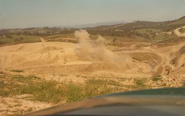
Photograph - Colour photograph, Cardinia Reservoir construction
Colour photograph of blasting works during the construction of the Cardinia Reservoir, Narre Warren East, in the 1970s. Plumes of dust rise from the orange sand and rock. In the distance low treed hills are visible. -
 Bendigo Historical Society Inc.
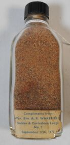
Souvenir - Bottle of Sand
10cm glass bottle filled with sand. Bottle has black plastic screw top. Label on bottom of bottle Wor.Bro A.R Wakefield - Golden and Corinthian Lodge No 7 September 12th 1970a.r. wakefield, golden and corinthian lodge -
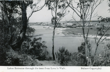
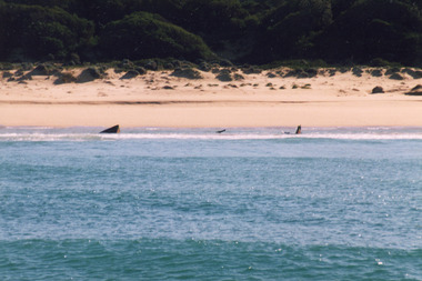
 Lakes Entrance Historical Society
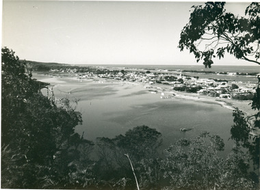
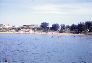
Photograph - Township, 1955
Also black and white postcard, similar view, titled Lakes Entrance through the trees from Lovers Walk. Bulmer copyright.Black and white photograph of a view from Kalimna Heights overlooking township. Shows North Arm, Marine Parade, Cunninghame Arm and sand hummocks with Bass Strait in distance. Lakes Entrance Victoriatownship, waterways -
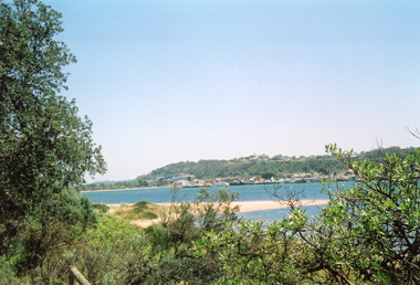
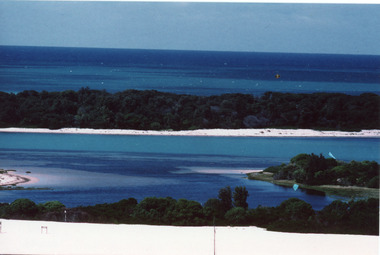
 Lakes Entrance Historical Society
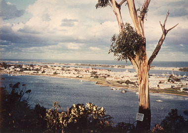
Photograph - Township, 1980
Also two different views of Lakes Entrance from KalimnaColour photograph showing the township situated on the land between the two stretches of water, the North Arm and the Cunninghame Arm. In the background can be seen the sand hummocks and the Southern Ocean. Lakes Entrance Victoria township, waterways -
 Buninyong Visitor Information Centre
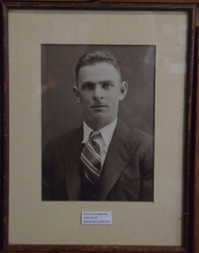
Photograph - Photograph , framed, Ray Flanagan
Portrait was framed by T.J. Haymes - Paint/Wallpaper Merchants, Ballarat. Photographer not known. Ray Flanagan was a long-time resident of Buninyong. Framed and mounted black and white photograph of Ray Flanagan. A note of the back of the photograph states that Ray lived with Miss Handley as a child boarder, at the back of the 'Sand and Soil (business), next to the Buninyong Cemetery. On front of mount board: Ray Flanagan, Lived S/E of Buninyong Cemetery. Label affixed to the back of the frame: T.J. Haymes - Paint/Wallpaper Merchants, Ballarat.ray flanagan, buninyong -
 Lakes Entrance Historical Society
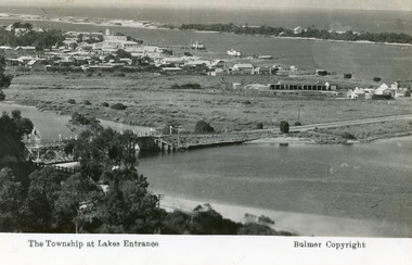
Postcard - Lakes Entrance, Bulmer H D, 1935
Marine Parade has not yet been formed through the low lying marshy area adjacent to North Arm. Very little vegetation on Eastern end of hummocks.Black and white postcard of the western end of Lakes Entrance,showing a glimpse of the North Arm bridge, town situated adjacent to Cunninghame Arm, sand hummocks and ocean in distance. Lakes Entrance VictoriaThe Township at Lakes Entrancetownship, waterways, bridges, hotels -
 Lakes Entrance Historical Society
Postcard - Township, 1935 c
Black and white photograph of a view from Kalimna Heights overlooking township. Shows North Arm, Marine Parade, Cunninghame Arm and sand hummocks with Bass Strait in distance. Lakes Entrance Victoriatownship, waterways -
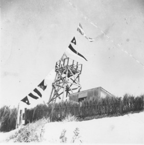 Lakes Entrance Historical Society
Photograph - Surf Lifesaving, 1938
Black and white photograph timber construction of Surf Lifesaving tower and equipment shed on sand dunes behind brush fence, flags strung from tower flagpole to fence. Lakes Entrance Victoriacommunity services, emergency services, beaches -
 Lakes Entrance Historical Society
Photograph - Lakes Entrance, Davies, Judy, 2005c
Colour photograph of Jemmys Point, Kalimna Heights, and the Western end of the township, taken from the southern shore of Cunninghame Arm. Small sand spit and natural vegetation in foreground. Lakes Entrance Victoriajetties, waterways, topography, township -
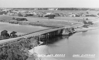 Lakes Entrance Historical Society
Photograph - North Arm bridge Lakes Entrance Victoria, Bulmer H D, 1945c
Notes: Club Hotel spit has not yet been formed. Also Postcard 8.5 x 13.5Black and white photograph of the North Arm Bridge, It shows the reinforced concrete bridge over the North Arm, and a rear view of other notable buildings. In the background sand hummocks. Lakes Entrance Victoriabridges, topography, township -
 Stawell Historical Society Inc
Photograph, Magdala Mine with woodstacks c1895
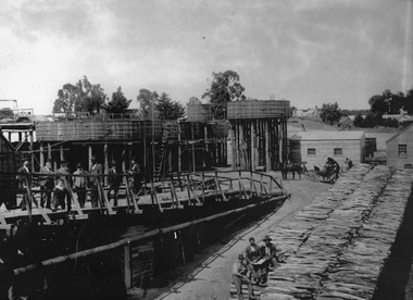
Magdala cum Moonlight Mine c1895. Showing wooden tanks and woodheap. Directors on left. The fifth from left tall man is Thomas Kinsella. A horse and dray would go up this ramp and take the crushed sand to the cyanide vats. To load drays with sand a horse would walk under a chute that was at the end of the conveyor belt and when sand was shoveled onto the conveyor, a dray could be loaded in 12 seconds.B/W Mr. Thomas Kinsella and gentlemen with young child leaning on rails overlooking wood stacks with three workers seated. Wooden vats, buildings. Three people by two horse buggy. labourer standing behind buggy.stawell gold mining -
 Flagstaff Hill Maritime Museum and Village
Equipment - Lead line
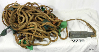
The lead line or hand lead is a simple navigational instrument used as a depth finder to measure the depth of water under the ship’s keel and to take samples of the sea bed. The long line may be marked at regular intervals with tags of different coloured and textured fabric, such as rope, leather and cloth. Each tag was a code to represent a certain depth. The leadsman’s eyes and hands could distinguish the depth easily as he drew in the lead line, day or night and in poor weather conditions. A standard set of codes for the tags was used so that the depth of the sea could be easily and quickly read. The measurement used was a Fathom, which equals 1.83 metres. The codes were: - 2 fathoms = 2 strips of leather 3 fathoms = 3 strips of leather 5 fathoms = white duck fabric 7 fathoms = red bunting fabric 10 fathoms = leather with a hole 13 fathoms = blue serge fabric 15 fathoms = white duck fabric 17 fathoms = red bunting 20 fathoms = 2 knots The lead weight could be between 7 -14 pounds (3.5 – 6.5kg) and the rope would be approximately 25 fathoms (45m). The hollowed-out end of the weight would hold a stick substance such as tallow or wax, which would pick up samples from the sea bed which would show whether the vessel was close to, or far away from, the shore. The leadsman would stand at the front of the vessel and cast the lead line into the sea. When it hit bottom he would note the tag marker nearest the surface of the water and call out his finding. Then he would haul it up again and examine the kind of matter that adhered to the end of the weight, whether it be sand, mud, gravel, or the colour of it. This information would be given to the ship’s helmsman or navigator and would help indicate the proximity to the land.This handheld lead is an example of early marine navigational equipment used by sailors to travel the seas to measure the depth of the water and sample the nature of the seabed. It helps to understand the history and progress made from the very basic to the sophisticated technology of today.Lead line, sounding line or depth finder. The long length of rope has a heavy lead weight attached to the end. Coloured fabric tags are tied onto the rope at regular intervals, representing different depths. The concave base of weight holds sticky substances such as tallow or beeswax, providing an adhesive surface to collect samples of sea bed like sand, shells or pebbles. flagstaff hill, warrnambool, shipwrecked coast, flagstaff hill maritime museum, maritime museum, shipwreck coast, flagstaff hill maritime village, lead line, depth finder, hand lead, sounding lin, leadsmane, navigation instrument, leadline, hand lead line -
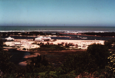
 Phillip Island and District Historical Society Inc.
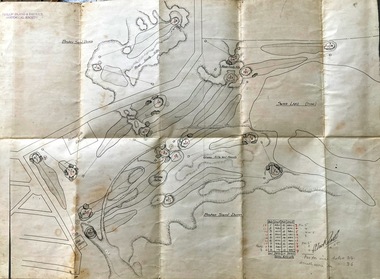
Map, Map of Summerland Golf Course, 15/12/1927
Summerlands Estate was created in the 1920s by A.K. T. Sampbell. It consisted of a housing estate, guest house and golf course. This area was acquired and all buildings, roads etc removed by the Victorian Government in the 1980s for a nature reserve for the penguins. This is believed to be the only time in the world when humans have been removed to benefit nature. HistoricalPurple leather covered fold out linen map with hand drawn diagram of the topography, layout of golf holes and club house Broken sand dunes, rough sandy hills, grassy hills and mounds, Swan Lake, Par for nine holes 34, Scratch score for nine holes 36, Drawn by A. Russell 12/12/1927summerland estate, summerlands golf course, a.k. t. sampbell, map, penguin reserve -
 Latrobe Regional Gallery
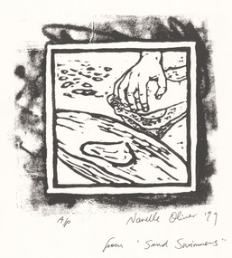
Print, OLIVER, Narelle, Wakati (p) Partulaca Seed for damper 1999, 1999
Linocut printSigned and dated 'Narelle Oliver '99' in lower right under printed image. Edition A/P, lower left under printed image. 'from 'Sand Swimmers" - written lower right corner of page. -
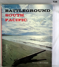 Bendigo Military Museum
Book, AH and AW Rees, Battleground South Pacific, 1970
Khaki hardcover book with dust jacket. Dust jacket has picture of a beach and sky with a gun barrel on the sand, pointing out to sea. Back cover has three smaller photos of battlefield debris.On second page "Donated by Bgo "Y" Men's Club"books, military battles -
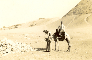 Federation University Historical Collection
Photograph - Black and White, Frank Wright at the Pyramids, 1940, May 1940
Frank Wright was a renown resident of Smeaton, where he was born. He lived at Laura Villa, and attended Smeaton State School. His father William was a gold miner and his mother's name was Sarah. Their family won many singing and instrumental awards. Frank was tutored by Percy Code and was awarded a gold medal for the highest marks in the ALCM examinations in the British Colonies at the age of seventeen years. He became the Australian Open Cornet Champion by the age of eighteen. A year later, Frank conducted the City of Ballarat Band, and later the Ballarat Soldiers’ Memorial Band. He formed the Frank Wright Frisco Band and Frank Wright and his Coliseum Orchestra. These bands won many South Street awards, and Frank as conductor won many awards in the Australian Band Championship contest. In 1933 Frank Wright sailed to England to conduct the famous St Hilda’s Band and was later appointed Musical Director of the London County Council, where he organized many amazing concerts in parks, in and around the London district. He was made Professor of Brass and Military Band Scoring and conducted at the Guildhall of Music and Drama. Frank was often invited to adjudicate Brass Band Championships around Europe, in Australia, including South Street and in New Zealand. The Frank Wright Medal at the Royal South Street competition is awarded to an individual recognized as making an outstanding contribution to brass music in Australia.Black and white photograph of a man sitting on a camel with the keeper standing at the camel's head. To the left is a pile of rocks and the rest of the background is sand rising to a dune and to the right is part of an Egyptian pyramid. The man is Frank Wright.Written in pencil on back - At the Pyramids, May 1940frank wright, egypt, pyramid, sand dune, camel -
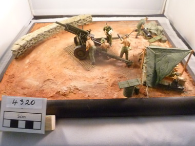 National Vietnam Veterans Museum (NVVM)
Model - Diorama, Australia guncrew serving 105mm Pack Howitzer
A diorama of some Australian guncrew soldiers working on a 105mm Pack Howitzer. Semi-permanent gun bay with sand bag wall. Crew accommodation (Hutchis) in foreground. Ammunition being prepared by a soldier in the background.105 pack howitzer, diorama -
 Lakes Entrance Historical Society
Photograph - Beaches, 2009
Date made January 2009Colour photograph showing western side of western pier. Rocks extend from end of pier along base of sand dunes, some vegetation on dunes. Signs and lights on piers. Lakes Entrance Victoria topography, beaches -
 Lakes Entrance Historical Society
Photograph - Mary Bernadette, 1990 c
Vessel wrecked 12 March 1985 near Lake Tyers BeachColour photograph of the remains of the fishing boat Mary Bernadette, these remains are usually covered with sand, exposed from time to time. Photograph taken from fishing boat offshore. Lake Tyers Beach Victoriashipwrecks, fishing industry -
 Lakes Entrance Historical Society
Photograph - Hopetoun Channel, Fraser, Ian, 1996c
Colour photograph of Bass Strait, scrub covered coastal dunes, Hopetoun Channel, and southern portion of Rigby Island. Photo taken from sand dunes on Flannagan Island, near Lakes Entrance, Victoria.islands, waterways, topography -
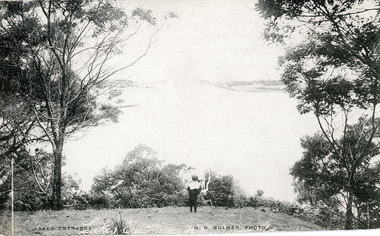 Lakes Entrance Historical Society
Postcard - The Entrance, Bulmer H D, 1910c
Also black and white enlargement size 16 x 25.| Note on back of postcard, 'Bemm River 16/8/11, To My Dear Elsie, Just a line....., Much love from all, Annie.'Black and white postcard of the man made entrance through the sand hummocks, taken from Jemmys Point. Small boy looking towards entrance, natural vegetation on brow of hill. Lakes Entrance VictoriaLakes Entrance waterways, topography -
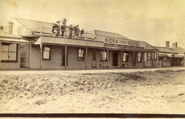 Lakes Entrance Historical Society
Photograph - Kiora House, 1920c
Also copy enlargement 12 cm x 19 cm Kiora House was purchased by Mrs C Beveridge from Mrs Begg. (Original building, A Murray's store, then Barkes store, before Barkes built near Post Office). House to the left purchased later, balcony built over veranda, this place removed and demolished for family home to be built later.Sepia toned photograph of Kiaora House. Houses on the left and the right. Sandy or Gravel roadway in front of building. Sand at the lake front in foreground of photo. People standing on upper balcony. Lakes Entrance VictoriaKiaora Housearchitecture, township, tourism, room display, local history -
 Lakes Entrance Historical Society
Photograph, Nelson Joan, 1980c
Colour photograph of the beach at the southern shore of Cunninghame Arm. It shows people swimming and paddling, also on the beach, coastal banksia and scrub on sand hummocks, surf lifesaving clubrooms in background. Lakes Entrance Victoriawaterfront, recreation -
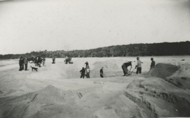 Lakes Entrance Historical Society
Photograph - Snowy River Marlo Victoria, 1940 c
No 3 in series of fiveBlack and white photograph taken looking back from ocean side showing vegetation in background and workmen with shovels horses and scoops opening an entrance through sand at mouth of Snowy River Marlo Victoriaenvironment, people, public works, waterways -
 Lakes Entrance Historical Society
Photograph - Bullock Island Lakes Entrance, 1995 c
historic Colour photograph of Bullock Island showing the first traffic bridge to the island, Ports buildings, Fishermans Co-op, planted grass and vegetation to bind sandy areas and deposits of sand in shallow North Armislands, waterways, revegetation -
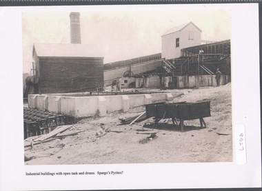 Bendigo Historical Society Inc.
Photograph - Spargo's Pyrites, Specimen Hill
Historic photo of mining at Specimen Hill. After crushing ore, the sand pyrites remaining could be treated to extract even finer gold. The sand was placed in large brick ovens to be roasted, which freed the sand of arsenic, sulphur etc, with the fumes containing these elements released into the atmosphere via a large chimney. Spargo's Pyrite Company operated from about 1870. It closed when there became a shortage of workers during WW1 and appears to have not restarted after the war. Black and white image, possibly copy. Weatherboard building on left hand side, elevated weatherboard building centre with chute descending to lower building. Possibly Spargo's Pyrites works, date unknownspargo's, pyrites -
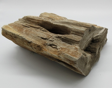 Hume City Civic Collection
Petrified Wood
This piece of petrified wood was found at the sand quarry between Sunbury and Bulla.A petrified piece of wood showing various shades of brown.smith, kevin, john, wood, george evans collection