Showing 10468 items
matching section
-
 Ballarat Tramway Museum
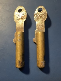
Functional object - MMTB Cincinnati "bundy" clock keys, Cincinnati Time Recorder Co. of Ohio, 1930s
Item used to operate and record the time in the Cincinnati Time Recording clock. This type of clock was used by the MMTB in the 1930s. The key would be issued by the depot staff to crews for use in the clock to record times so that they could be matched up against the timetable to see whether tram or bus services were running on time. Understood that this style of key was last used on the Port Melbourne bus route. The Museum has one of these clocks at its depot which was obtained from The Met in? The second photo shows the key in position before turning the handle around it. By the 1960's (or earlier) they were only used on the M&MTB bus routes. All the tram routes had M&MTB copies with a very different style of key. Only used on two man bus routes and the conductor held the key due to the half-cab bus design. On the tram routes the driver was responsible for the key and recording the time. The key number represented the crew's shift number. For a while towards the end of their use on the trams they were the Run number. This change led to many lost keys! See item 9568 for an example of the time recording clock itself.Demonstrates a Cincinnati "Bundy" time recording clock key.Key - or Bundy Clock key made for a Cincinnati Time Recording Clock comprising a circular brass section with a key number section secured by a screw at one end and a flat steel strip inserted into the brass section, with a hole at one end that could be placed on a hook. The steel strip is riveted into the brass round section. Two keys held.Steel section stamped "tramways" and "55" and "263"tramcars, tramways, bundy clock, cincinnati, time recorder clocks -
 Warrnambool and District Historical Society Inc.
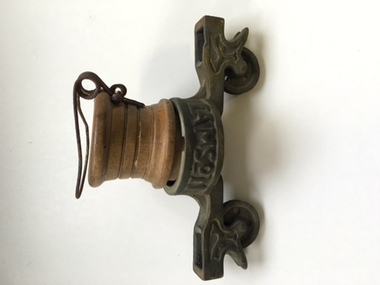
Equipment - Artefact, Lamson's Rapid Wire Cash Carrier, Youngers, C Early 20th century
Lamson was established in Australia in 1898 with the idea for a store security money handling system being patented in the latter part of the 19th century.The practise of taking money from the counter and customer to the cashier was time consuming and cumbersome.Some bright ideas were employed including tying the money and dockets in a hankerchief and throwing it to the cashier. The first attempt to improve this was the ball system where a ball containing the cash was rolled to the cashier on an elevated track. The rapid wire system superseded this in the early 1900's and for the next 50 years it became a popular part of money handling in stores around Australia. This particular Lamson's cash carrier was installed in Youngers department store which was situated in Liebig Street. The success of Youngers store was partly responsible for the shift to Liebig St as the main commercial district. The Warrnambool Standard reported in 1901 that Younger and Co would operate on a wholly cash basis replacing incidental trades of goods such as potatoes and other farm produce.This item has strong social and historical significance. Apart from having strong links to one of Warrnambool's largest and longest running businesses, the object itself is of considerable interest with thousands of the original ball systems and Rapid Wire cash carriers being in use around the world. Cylindrical brass top with central circular part with section either side which have two small pulleys. A wooden cylindrical section slots in below with a wire clip attached at the bottom.Lamson is cast into the brass on either side of therim of the top circular section. . AUS is on the side of this same section. warrnambool,, youngers, youngers warrnambool, lamson, lamson rapid wire cash carrier, wire cash carrier -
 Working Heritage Crown Land Collection
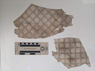
Decorative object - Wallpaper, Horticultural Hall wallpaper
Sample of wallpaper from the "west wall" of Horticultural Hall.Sample section of wallpaper from Horticultural Hall. Cross section of squares interlaced with geometric shapes. wallpaper, horticultural hall -
 Warrnambool RSL Sub Branch
Light Bomb, 1940s ?
UnknownLight Weight bomb is made from 3 parts. The cylinder head section made of light steel screws onto the main body which is Aluminium and has a cylinder shape and screwed to the body section is a tin fin sectionSome what appears to be Japaness writing on the heads sectionlight weight bomb ww2 -
 Warrnambool RSL Sub Branch
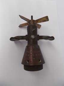
Bomb Tail firing cap, Around late 1938 to 1945
A cone shape at the base section with a cylinder section on the top half made of brass and is screwed onto the rear section of and Arial Bomb. There are 2 leavers either side of the cylinder section which open out after the bomb has been dropped from a plane ,this helps slow the bombs decent and with a brass propeller at the very top of the devise helps to activate the firing pin and arming the bombThere are a number of Japaness markings on the cone section with some numbersww2 japaness bomb arming mechanisum -
 Kilmore Historical Society
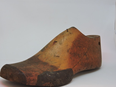
Tool - Shoe Last, Left foot Wooden Shoe Last, April 2002
dark timber staining on upper. 2 nails on upper. hole through heel. screw attaching arch to sole section. hole part way through inside arch12,4 stamped on upper section. 5562 stamped on sole section. -
 Bendigo Historical Society Inc.
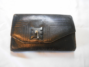
Textile - BLACK LEATHER HAND BAG, 1920s >
Textiles. Black leather hand bag with very decorative black bakelite clasp with silver twist fastener on front flap. Inside front has zippered section,(broken). Inner section has Art deco clasp with silver fitting on centre purse section. Centre section containing a coin purse on a silver bar. Side sections have side pockets- inside linings and purse of taffeta fabric.Label on inside purse section, ''Guarenteed First Quality A CB Bag''textiles, domestic, black leather hand bag -
 Ringwood and District Historical Society
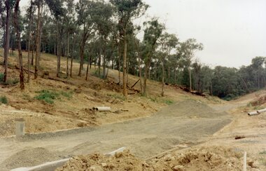
Photograph, The unfinished section of Debbie Place, North Ringwood in February 1979
E552 N23 Part of a 51-photo record of the development of the "Kubis" Estate, Ringwood North, including road works to Debbie Place, Kubis Drive, Werac Drive, Manuelo Drive, Iluka Place and Glenvale Road. From the Jack Lundy Clarke collection. -
 Ringwood and District Historical Society
Plans - Freeway, Country Roads Board, Victoria, Eastern Freeway Ringwood Section - Planning Report on Suggested Concepts Investigation (Country Roads Board) 1974, 1974
Report on suggested concepts investigation for freeway.Report on suggested concepts investigation for freeway. Buff coloured covers with brown printing. Bound with brown Spirex. pp. 39. -
 Warrnambool and District Historical Society Inc.
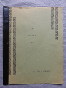
Book, A section of Poems, Mid 1930s
This booklet of poems has been compiled by Thomas Terrington. Born in 1897 Tom Terrington worked at dairying, fencing, carpentering and woodcutting before taking over the Framlingham store when he was in his forties. He was a scholarly person with a wide knowledge of English literature. He was a well-known local poet and a member of the Australian Poetry Lovers’ Society. He wrote extensively on local history and his unpublished ‘History of Framlingham’ is in the State Library. Framlingham is a small settlement 25 kilometres north east of Warrnambool. This booklet is of interest as it contains some of the poems written by Tom Terrington, an important resident of Framlingham in the 20th century. This is a soft cover book of 24 pages. The cover is green with black decorative borders and black binding. The pages have black printing on green paper. The last few pages are missing. The cover is faded and a little torn. There are ornamental scrolls and patterns in black throughout the pages. tom terrington, history of framlingham -
 Eltham District Historical Society Inc
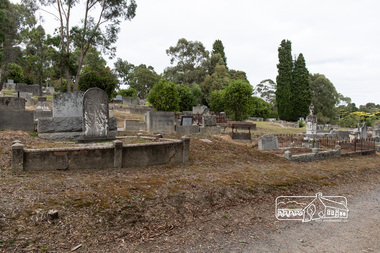
Photograph, Peter Pidgeon, Morris, Knapman and Armstrong graves, Church of England Section, Eltham Cemetery, Victoria, 5 April 2021
Born Digitaleltham cemetery, gravestones, ada gertrude armstrong, alfred armstrong, arthur reynolds stockwood armstrong, arthur vivian harrison, laura augusta harrison (nee armstrong), margaret armstrong, mary armstrong, george knapman, mary jane knapman (nee williams), alfred george morris, janet morris, william morris -
 Eltham District Historical Society Inc
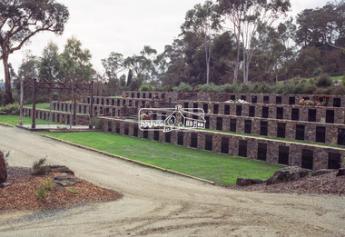
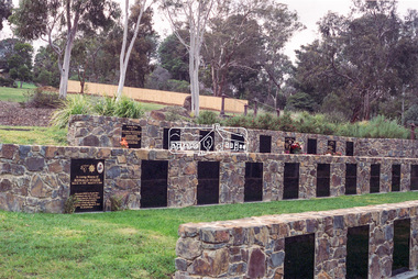
Negative - Photograph, Harry Gilham, Terrace Wall Section, Eltham Cemetery, Mount Pleasant Road, Eltham, 1 Aug 2007
Richard Gilsenan was a retired schoolteacher living at “Rosebank” in Eltham, now the site of the Living and Learning Centre. In 1906, Eltham Primary School’s headmaster John Brown died, and Richard was brought out of retirement (briefly) to be acting headmaster. His son Harold was a junior teacher there at the time. Thereafter, Richard was Secretary of the Eltham Progress League and more importantly was a magistrate at the Eltham Court of Petty Sessions. Cases commonly brought before him included not sending a child to school (typical fine 5/- or eight hours in the lock-up), not having a child vaccinated (fixed fine 40/-), stealing fruit from an orchard, selling liquor out of hours, and offensive language and behaviour. Other miscellaneous cases were allowing cattle to wander, selling cigarettes to a minor, carelessly burning off rubbish on a hot windy day, dumping a dead horse in the Diamond Creek, and youths throwing ripe fruit at passers-by. Richard died in 1920 and is buried in Eltham Cemetery with his wife Harriet Eliza. In mourning his passing, his peers noted that his decisions had been given in a very fair way. Incidentally, his son Harold (the teacher) died in 1921 after being trampled by a horse while en route from Eltham to Cathkin (his then school). In Loving Memory Of Richard Edward Gilsenan Died 30th July 1920 Aged 73 years Also Harriet Eliza Beloved wife of above Died 7th Sept. 1933 Aged 78 years Sweet Rest And In Loving Memory Of Barbara Ann Beloved wide of G. R. Gilsenan Died 18th Sept. 1917 Aged 38 years Also the above George Richard Gilsenan Died 2nd Nov. 1918 Aged 40 yearseltham cemetery, gravestones, memorials -
 Eltham District Historical Society Inc
Negative - Photograph, Harry Gilham, Terrace Wall Section, Eltham Cemetery, Mount Pleasant Road, Eltham, 1 Aug 2007
Richard Gilsenan was a retired schoolteacher living at “Rosebank” in Eltham, now the site of the Living and Learning Centre. In 1906, Eltham Primary School’s headmaster John Brown died, and Richard was brought out of retirement (briefly) to be acting headmaster. His son Harold was a junior teacher there at the time. Thereafter, Richard was Secretary of the Eltham Progress League and more importantly was a magistrate at the Eltham Court of Petty Sessions. Cases commonly brought before him included not sending a child to school (typical fine 5/- or eight hours in the lock-up), not having a child vaccinated (fixed fine 40/-), stealing fruit from an orchard, selling liquor out of hours, and offensive language and behaviour. Other miscellaneous cases were allowing cattle to wander, selling cigarettes to a minor, carelessly burning off rubbish on a hot windy day, dumping a dead horse in the Diamond Creek, and youths throwing ripe fruit at passers-by. Richard died in 1920 and is buried in Eltham Cemetery with his wife Harriet Eliza. In mourning his passing, his peers noted that his decisions had been given in a very fair way. Incidentally, his son Harold (the teacher) died in 1921 after being trampled by a horse while en route from Eltham to Cathkin (his then school). In Loving Memory Of Richard Edward Gilsenan Died 30th July 1920 Aged 73 years Also Harriet Eliza Beloved wife of above Died 7th Sept. 1933 Aged 78 years Sweet Rest And In Loving Memory Of Barbara Ann Beloved wide of G. R. Gilsenan Died 18th Sept. 1917 Aged 38 years Also the above George Richard Gilsenan Died 2nd Nov. 1918 Aged 40 yearseltham cemetery, gravestones, memorials -
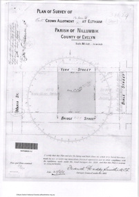
 Eltham District Historical Society Inc
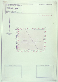
Slide - Photograph, Eltham Shire Council, Plan of Subdivision, Crown Allotment 8, Section 8A, Parish of Nillumbik,County of Evelyn, 1969
35mm colour positive transparency blue Agfacolour Service plastic mountC1, Pain, Sibbel and Carter, Research-Warrandyte Road, North Warrandyte, 4 August 1969carter, infrastructure, map, north warrandyte, pain, parish of nillumbik, plan of subdivision, planning, research-warrandyte road, sibbel, subdivison lots -
 Eltham District Historical Society Inc
Slide - Photograph, Eltham Shire Council, Plan of Subdivision of Part of Crown Allotment 4, Section 2 at Kangaroo Ground, Parish of Nillumbik, County of Evelyn, 1969
35mm colour positive transparency blue Agfacolour Service plastic mountC6, Kimse, Kangaroo Ground-St Andrews Road, 4 August 1969infrastructure, kangaroo ground, kangaroo ground-st andrews rd, kimse, map, plan of subdivision, planning, subdivison lots -
 Eltham District Historical Society Inc
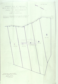
Slide - Photograph, Eltham Shire Council, Tentative plan of subdivision, part of Crown Allotment 22, Section B, Parish of Greensborough, County of Evelyn, 1969
35mm colour positive transparency blue Agfacolour Service plastic mountE11, N1069, Stogryn, Sub 'prop',infrastructure, map, planning, subdivison lots -
 Eltham District Historical Society Inc
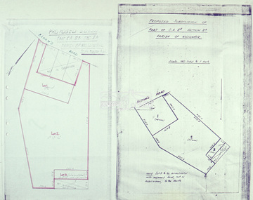
Slide - Photograph, Eltham Shire Council, Proposed subdivision of Part of Crown Allotment 8B, Section 8A, Parish of Nillumbik, 1969
35mm colour positive transparency blue Agfacolour Service plastic mountE4, N0424, Stock subdivision, North Warrandyte, 4 August 1969infrastructure, map, planning, subdivison lots -
 Eltham District Historical Society Inc
Slide - Photograph, Eltham Shire Council, Plan of Subdivision, Part of Crown Allotments 5 & 6, Section 10, Parish of Nillumbik, County of Evelyn (Foster Road, Eltham East), 1969
35mm colour positive transparency blue Agfacolour Service plastic mountC5(a) DU (Vic) D/L Foster Road, Eltham East, 4 August 1969infrastructure, map, planning, subdivison lots, abersham court, ancona close, eltham east, floriston grove, foster road, frank street, gladwyn court -
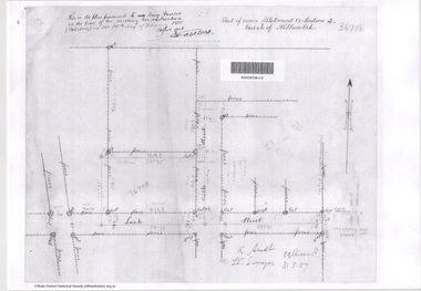
 Eltham District Historical Society Inc
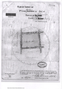
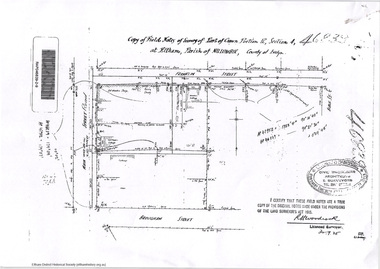
Document - Photocopy, Survey Fleld Notes of Part of Crown Portion 13, Section 4 at Eltham, Parish of Nillumbik, County of Evelyn, 1902-1903
Main Road, Henry Street to Diamond Street; Silver Street to Bible Street Application No. 0337771902, 1903, arthur street, bible street, bird street, diamond creek (creek), diamond street, eltham, eltham railway station, henry street, main road, silver street, survey plan, vine street, application 33777, map -
 Eltham District Historical Society Inc
Document - Photocopy, Survey Fleld Notes of Part of Crown Portion 13, Section 4 at Eltham, Parish of Nillumbik, County of Evelyn, 18 May 1908
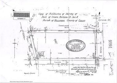
Portion of land bounded by: Main Road, Luck Street, Bible Street, Arthur Street Application 37314 W. P. Steane, M.C.E. Civil Engineer and Surveyor, 18 May 1908application 37314, arthur street, bible street, eltham, luck street, main road, map, survey plan -
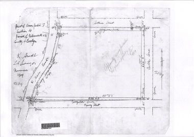
 Eltham District Historical Society Inc
Document - Photocopy, Survey Fleld Notes of Part of Crown Portion 13, Section 4 at Eltham, Parish of Nillumbik, County of Evelyn, 31 May 1907
Portion of land east of Main Road and north of Luck Street bounded by Bible Street Application 36708 K. Arndt, Licensed Surveyor, 31 May 1907application 36708, bible street, eltham, luck street, main road, map, survey plan -
 Eltham District Historical Society Inc
Document - Photocopy, Survey Fleld Notes of Part of Crown Portion 13, Section 4 at Eltham, Parish of Nillumbik, County of Evelyn, November 1909
Portion of land bounded by Main Road, Arthur Street, Bible Street, Henry Street Application 36708 K. Arndt, Licensed Surveyor, November 1909application 5289, arthur street, bible street, eltham, henry street, main road, map, survey plan -
 Eltham District Historical Society Inc
Document - Photocopy, Survey Fleld Notes of Part of Crown Portion 12, Section 4 at Eltham, Parish of Nillumbik, County of Evelyn, 12 October 1910
Portion of land bounded by: Main Road, John Street, Bible Street, Pitt Street Application 38858 K. Arndt, Licensed Surveyor, 12 August 1910application 38858, bible street, eltham, john street, main road, map, pitt street, survey plan -
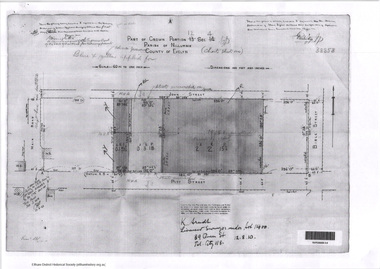
 Eltham District Historical Society Inc
Document - Photocopy, Survey Fleld Notes of Part of Crown Portion 12, Section 4 at Eltham, Parish of Nillumbik, County of Evelyn, 20 May 1911
Portion of land bounded by: Main Road, York Street, Bible Street, Bridge Street Application 38629 Frederick Dudley Smith, M.C.E. Licensed Surveyor, 20 May 1911application 38629, bible street, bridge street, eltham, main road, map, survey plan, york street -
 Eltham District Historical Society Inc
Document - Photocopy, Survey Fleld Notes of Part of Crown Portion 13, Section 4 at Eltham, Parish of Nillumbik, County of Evelyn, 7 January 1924
Portion of land north of Luck Street bounded by: Main Road, Bible Street Application 9991 R. Woodstock, Land Surveyor, 7 January 1924application 9991, bible street, eltham, luck street, main road, map, survey plan -
 Eltham District Historical Society Inc
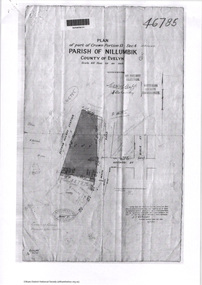
Document - Photocopy, Survey Fleld Notes of Part of Crown Portion 13, Section 4 at Eltham, Parish of Nillumbik, County of Evelyn, 7 May 1925
Portion of land bounded by: Main Road, Eltham Railway Station Application 46785 J.T. Robinson, Surveyor, 7 May 1925application 46785, arthur street, bible street, eltham, eltham railway station, luck street, main road, map, survey plan -
 Eltham District Historical Society Inc
Document - Photocopy, Survey Fleld Notes of Part of Crown Portion 12, Section 4 at Eltham, Parish of Nillumbik, County of Evelyn, 30 September 1925
Portion of land bounded by: Main Road, Franklin Street, Bible Street, Brougham Street Application 46839 R. Woodcock, Licensed Surveyor, 30 September 1925application 46839, bible street, brougham street, eltham, franklin street, main road, map, survey plan -
 Eltham District Historical Society Inc
Survey Fleld Notes of Part of Crown Portion 13, Section 4 at Eltham, Parish of Nillumbik, County of Evelyn, 17 May 1926
Portion of land bounded by: Eltham Railway Station, Main Road, Luck Street, Arthur Street Application 4182/215 J.T. Robinson, Licensed Surveyor, 17 May 1926application 4182/215, arthur street, eltham, eltham railway station, luck street, main road, map, survey plan -
 Eltham District Historical Society Inc
Document - Photocopy, Survey Fleld Notes of Part of Crown Portion 12, Section 4 at Eltham, Parish of Nillumbik, County of Evelyn, 18 March 1926
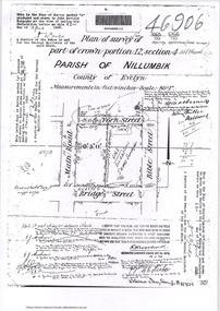
Portion of land bounded by: Main Road, York Street, Bible Street, Bridge Street Application 46906 R.H. Woodcock, Licensed Surveyor, 18 March 1926application 46906, bible street, bridge street, eltham, main road, map, survey plan, york street -
 Eltham District Historical Society Inc
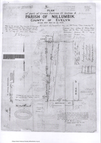
Document - Photocopy, Survey Fleld Notes of Part of Crown Portions 12 & 13, Section 4 at Eltham, Parish of Nillumbik, County of Evelyn, 6 May 1929
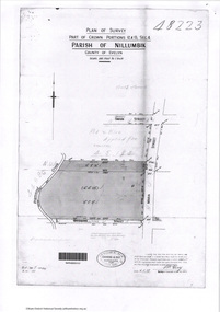
Portion of land bounded by: Main Road, York Street, Diamond Creek, Swan Street Application 48223 P.N. Guy, Licensed Surveyor, 6 May 1929application 48223, diamond creek (creek), eltham, main road, map, survey plan, swan street, york street