Showing 10760 items
matching site
-
 Greensborough Historical Society
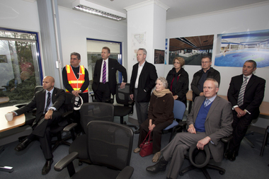
Photograph - Digital image, Watermarc under construction: Visitor group seated in site office, 18/05/2012
Visitors group seated in site office. The redevelopment of the Greensborough Pool into the Watermarc aquatic centre is documented in this collection of photographs from the collection of Rosie Bray. These photographs taken on a ‘Community Consultative Committee’ walkthrough prior to completion of Watermarc, May 18 2012.Digital copy of colour photograph.watermarc, greensborough swimming pool, rosalie bray -
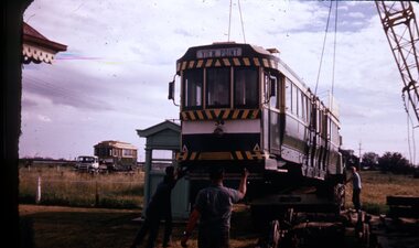
 Ringwood and District Historical Society
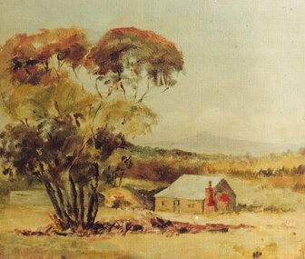
Photograph, Painting by Mrs. Miles of the first mine manager's cottage at mine site, East Ringwood. (No record of date)
Catalogue card reads, "Print of oil painting done by Mrs. Miles of first miners cottage used for mine manager". Written on back of picture, "Painting by Mrs. Miles of the first mine manager's cottage at mine site, East Ringwood. He was relative of Edith Gluth who lent the painting for photo copying". -
 Lara RSL Sub Branch
World War 2 War Graves of Lara Men, Photograph of Head Stone of grave site Pte. A. Bowler at Bomana War Cementary, New Guinea and Grave Site of Flight Lieutenant J.S. Austin DFC grave site Adelaide River, N. T
Flt Lt J S Austin DFC, 400363. No 608 Sqn RAF, Nos 32, 13 & 2 Sqns. Stock agent of Lara, Vic; b Melbourne 15 May 1918. Died of illness 9 Nov 1943. Timor was the target for the night of 6 July, when Flight Lieutenant "Bunny" Austin (A16-207) led five Hudsons to bomb Koepang town. The next night he led back seven aircraft against the airfield at Penfoei, attacking before dawn on the 8th prior to United States Liberators bombing the runways and barracks. 75 Austin's aircraft was caught by Penfoei's master defensive searchlight, and Austin used violent evasion and switching on and off of his IFF equipment, a tactic used in Europe. The radar-controlled searchlights went out. Flying Officer Mick Helsham (A16-160) attacked first to act as a pathfinder and mark the target for the other Hudsons and Liberators:Full service records of J. S. Austin held by Lara R.S.L.Plain Sheet A4 paper with 2 photographs 1. A. Bowler W. 9.8 cm H. 13.8 cm photograph 2. J.S. Austin W. 1`5.9 cm H. 10.0 cmA4 sheet heading as: W.W. 2 War Graves of Lara Men. Note on photograph 1. Grave of A. Bowler, Bomana War Cemetery.r.a.f., graves, lara -
 Stawell Historical Society Inc
Photograph, Stawell Wheat Site Construction beside the main rail line behind the Pleasant Creek Training Centre and Woollen Mills -- Demolished 1945-1946
Building Stawell Wheat Site situated beside the main rail line behind the Pleasant Creek Training Centre and Woollen Mills. Demolished 1945-1946stawell -
 Federation University Historical Collection
Photograph - Photograph - Colour, Site of the State Revenue Office, Ballarat Technology Park, c2000
The State Revenue Office (SRO) is a $5 million world-class purpose built revenue collection facility employing over 200 people. SRO relocated 40% of its operations from Melbourne to the Ballarat Technology Park, creating more than 180 employment opportunities for skilled people from the region. The Ballarat facility houses the majority of the SRO's operations capability and utilises state-of-the-art technology. The BTP was selected to host the SRO after a feasibility study revealed that Ballarat was an ideal regional centre to support this important government function. The BTP enables the SRO to be in close proximity to an existing cluster of technology based enterprises and organisations, as well as education, training and research opportunities presented to SRO staff at the nearby Federation University. Three coloured photographs of people on the site of State Revenue Office, Ballarat Technology Park. The man being interviewed is Premier John Brumby. Geoff Howard MP and University of Ballarat Vice Chancellor Kerry Cox stand to his right. Two hundred State Revenue Office (SRO) workers were shifted to Ballarat from Melbourne in 2001 in a government initiative to create regional growth and cost savings.ballarat technology centre, john brumby, kerry cox, geoff howard, university of ballarat, state revenue office -
 Ballarat Tramway Museum
Slide - 27 mm sq slide/s - set of 2, Lilian Butler, construction of new town houses on the former SEC Depot site in Wendouree Parade, Jun. 1973
Yields information about the appearance of the units being constructed on the former depot site with an association of the parties involved.Set of two Colour 27 x 27 mm slides in Kodachrome cardboard mounts of the construction of new town houses on the former SEC Depot site in Wendouree Parade - one over exposed. The first one has the board for the construction of the homes by Prestige Homes and the agents name - B.E. Hayden & Co. Pty Ltd. Slide mount dated June 1973. Photo from the collection of Lilian Butler.Both slides have in pencil "old tram sheds" at the top of the slide.ballarat, tramways, trams, depot, sec depot, wendouree parade, construction -
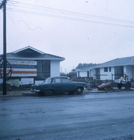
 Greensborough Historical Society
Photograph - Digital Image, Bundoora State School site, Redevelopment sign Bu1915, 01/10/2017
This photograph shows the Auction notice for the redeveloped site, formerly Bundoora State School. The original school building was incorporated into the redevelopment to provide a modern child care facility.Digital copy of colour photographbundoora primary school, bundoora state school, plenty road bundoora, childcare centre -
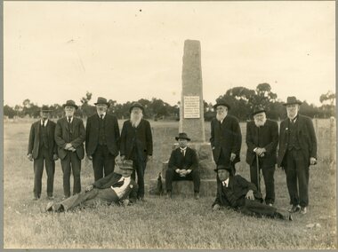 Stawell Historical Society Inc
Photograph, "Peace" Memorial on Halls Gap Road built 1919 at site of old Treasury Building Commercial Street Pleasant Creek c1922
Group of Gentlemen beside the Peace Memorial situated on Halls Gap Road built 1919 at site of old Treasury Building Commercial Street Pleasant Creek. C1922stawell -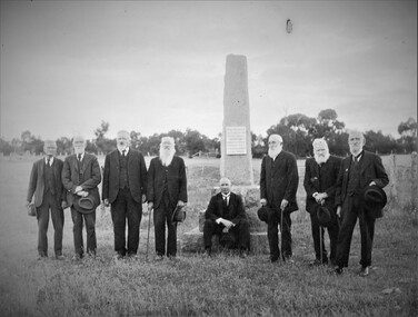
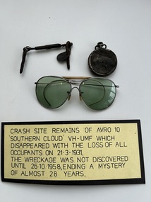 Moorabbin Air Museum
Memorabilia (Item) - VH-UMF Avro 10 Southern Cloud Crash Site Remains
-
 Ballarat Tramway Museum
Slide - 35mm slide/s, John Radcliffe, Ballarat No. 34 being unloaded at the AETM site, 24/09/1971 12:00:00 AM
Yields information about the delivery of an ex Ballarat tram to a tramway Museum.Colour 35mm slide in a white cardboard slide holder of Ballarat No. 34 being unloaded at the AETM site on 24-9-1971, Photo John Radcliffe. Ballarat No. 21 can be seen in the background on a truck waiting to be off-loaded. In the adjacent slide position is a note to this effect. This piece of paper was wrapped around the slide. Photo from the collection of Lilian Butler. See also Reg Items 7988i1 and i2 for other photographs.Written around the slide in ink "Unloading Ballarat car 34 at Australian Electric Transport Museum (SA) Inc St Kilda SA - Ballarat car 21 at rear - 24-9-1971. J. C. Radcliffe photo."tramways, trams, ballarat, aetm, sale of trams, adelaide, tram 34 -
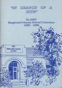 Ringwood and District Historical Society
Booklet - Book, In Search of a Site, 1989
History of the Ringwood Primary School No 2997 from 1889 to 1989 Contents include List of Head Teachers/Principals, Finding a Site, Time Line, Reminiscences of Miss Daisy Paddock, Anecdotes From Former Pupils. Acknowledgement - In researching the history of Ringwood Primary School, we would like to acknowledge the valuable information obtained from the History of Ringwood Primary School compiled by Mr. J.A. Baines. -
 Eltham District Historical Society Inc
Photograph, Eltham Town Park (previous tip site)
One of a set of display images thought to be produced by the Shire of Eltham c.1979-1987. The Eltham Town Park was a reclaimed tip site. It was later named the Alistair Knox Park Illustrative of services provided by former Shire of ElthamColour photograph 20 x 29 cm mounted on green-painted cardboard 25.5 x 30.5 cmTitle printed on label adhered to board below photograph (replaced June 2017)eltham town park, alistair knox park -
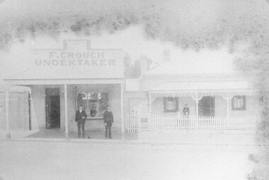 Stawell Historical Society Inc
Photograph, Mr Frank Crouch -- Undertaker, established 1862 in Main Street Stawell with private residence on site still being used
F. Crouch (Established 1862) Main Street and private residence on site still being used. The business premises are built of bricks brought from the original building in Stawell West.stawell -
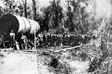 Stawell Historical Society Inc
Photograph, Large Boiler being transported by Horses from the Magdala Mine Site in Stawell to the Heatherlie Quarry
Large Boiler being transported by Horses probably in location of Fyans Creek. Boiler being transported from the Magdala Mine Site in Stawell to the Heatherlie Quarry to replace unserviceable Boiler.stawell industry mining -
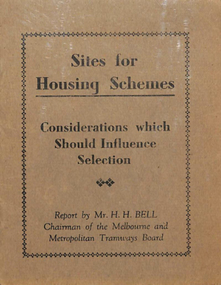 Melbourne Tram Museum
Book, H. H. Bell, "Site for Housing Schemes - Considerations which should influence Selection", c1939
Book - light grey covers + 8 pages on off white paper, centre stapled titled "Site for Housing Schemes - Considerations which should influence Selection", written by H. H. Bell, Chairman of the MMTB c1939, as it notes the recommendation to use diesel buses on the Bourke St routes. This was done following his overseas tour of 1938. Includes comments on housing schemes and transport in the UK, USA, Melbourne, diesel buses and fares.trams, tramways, public transport, buses, housing, bourke st, overseas tours -
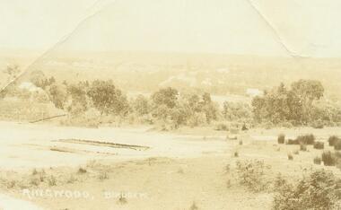 Ringwood and District Historical Society
Photograph, Ringwood Birdseye - Looking towards Ringwood from later site of Civic Centre in Braeside Avenue, Ringwood East
Typed below photograph, "Looking towards Ringwood from present site of Civic Centre. Old Catholic Church which stood on Maroondah Hwy. and Mt. Dandenong Rd. intersection can be seen on right. Maroondah Hwy. can be seen where it goes past lake, also station masters residence, and houses in Pitt St. and Bedford Rd." -
 Greensborough Historical Society
Journal - Article, Journal, Victorian Historical Journal, Batman's route revisited: his exact steps to a new treaty site, 2014_06
Article from the Victorian Historical Journal Vol.85, No.1, June 2014. Discusses John Batman's 1835 visit to Port Phillip and possible alternative sites for signing his treaty with Indigenous people of the area.21 pages, maps.john batman, batmans treaty -
 Eltham District Historical Society Inc
Photograph, Eltham Town Park (previous tip site)
One of a set of display images thought to be produced by the Shire of Eltham c.1979-1987. Eltham Town park is a reclaimed tip site and was later named the Alistair Knox Park. It is located in Main Road, ElthamIllustrative of services provided by former Shire of ElthamColour photograph 20 x 29 cm mounted on green-painted cardboard 25.5 x 30.5 cmTitle printed on label adhered to board below photograph (replaced June 2017)eltham town park, alistair knox park -
 Greensborough Historical Society
Map - Map (Copy), C. Hodgkinson, District Surveyor et al, Parish of Yan Yean 1856: Village site during construction of the Yan Yean Reservoir, 1978
Copy of map part Sec. 13, Parish of Yan Yean 1856, Map 3, Village site... Scale: 8 chains to 1 inch. Drawn by C. Hodgkinson, District Surveyor, redrawn by A. R. Blair 1978. 1 p. photocopy of map. yan yean reservoir, yan yean -
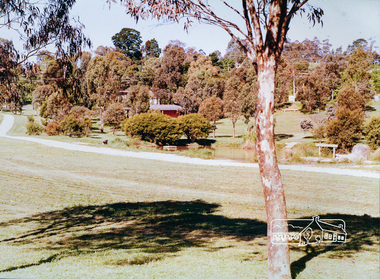
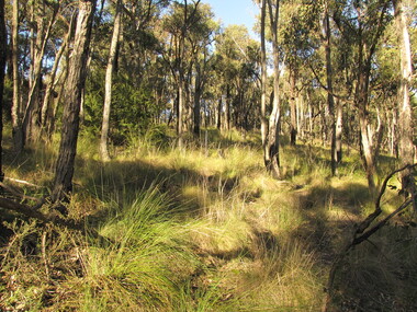 Round the Bend Conservation Co-operative
The Co-operative's aim of living in harmony with the bush provides a sanctuary for both flora and fauna in its box ironbark forest and grassy dry forest, 1980's
Colour photographround the bend co-op, environmental living zone elz -
 Falls Creek Historical Society
Document - Proposed Chalet At Site 4
Bob (Herman) Hymans (a former member of the Royal Netherlands Navy) was born in Bloemendaal, Holland on 30th September 1922. During World War II he fought against the Japanese in the Dutch East Indies (now Indonesia) and was imprisoned in Changi and on the Burma Railway. After gaining qualifications as a Ski Instructor, Bob arrived in Falls Creek in July 1950. Working as an Instructor and Supervisor at Bogong Lodge, Bob decided his future was in accommodation. He was successful in negotiating an indenture for land from the State Electricity Commission (SEC). It took Bob two years to build his Grand Coeur Chalet but, tragically, it was burned down in August 1961. Bob also built the first Chairlift in Australia. This was a single chairlift and the structure was built from wooden electricity poles. He was constantly full of new ideas and proposals for the village. Bob Hymans died on 7th July 2007. This Collection of documents and letters tells the story of Bob's endeavours to develop Falls Creek into the ski village it is today.This item is significant because it documents proposals put forward by Bob Hymans to develop facilities in the Falls Creek Tourist Area.A letter from J. Dale Fisher, an architect acting on behalf of Mr Hymans. The letter accompanied plans submitted to the SEC and the Management Committee for approval of the development of SIte 4, Christie Street, Falls Creek. The plans had been modified in response to earlier concerns related to cost. The new chalet would provide accommodation and a swimming pool and stables. Mr Hymans aimed to build a chalet which operated year round and would rival any of the resorts in New South Wales.falls creek tourist area management committee, bob hymans, falls creek administration -
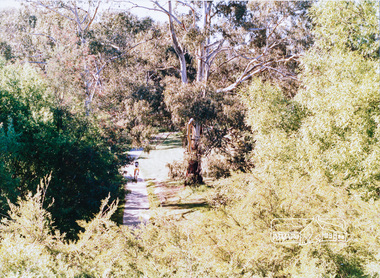
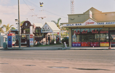 Lakes Entrance Historical Society
Photograph - Esplanade Lakes Entrance Victoria. Site of original Claremont Guest House, M Holding, 2006
Esplanade showing Black Ball Basket Mini Golf and Slipway Cafe. Narrow lane between businesses to access rear residences. Phone booth and garbage bin on footpath Lakes Entrance Victoria. Site of original Claremont Guest HouseColour photograph of businesses on Esplanade showing Black Ball Basket Mini Golf and Slipway Cafe. Narrow lane between businesses to access rear residences. Phone booth and garbage bin on footpath Lakes Entrance Victoriaroads and streets, historic site, recreation, entertainment -
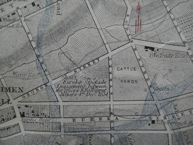 Ballarat Heritage Services
Photograph - Digital photograph, Map Detail Showing the Eureka Stockade site, 1861
Eureka Stockade is the site of the battle between government forces and miners and occurred on 3 December 1854 early one Sunday morning. Around 30 were killed, 130 arrested and 13 tried for High Treason. Many were injured in the affray. digital photographEureka Stockade Engagement between the troops and Ballarat Miners 4th December 1854. * Please note the date is recorded wrongly on the map.eureka site, map, george street, cattle yards, eureka street, ballarat, eureka stockade -
 Eltham District Historical Society Inc
Negative - Photograph, George W. Bell, Excavation of site for new Eltham Shire Office building, 895 Main Road, Eltham, 1964
Black and white photograph of bulldozer excavating the former Shillinglaw Cottage site for new Shire Offices. 'Shillinglaw Trees' in background. The cottage and land were purchased by the Shire of Eltham as the site for a new shire office building. The cottage was destined for demolition but members of the community concerned at losing one of the areas earliest buildings (built c.1859) initiated a fund-raising campaign to save the cottage. In 1964 the cottage was dis-assembled, all the bricks numbered and reassembled several hundred meters to the south on a site between the Gahan house and the Eltham Railway Trestle Bridge (present-day Panther Place), which became known as the Eltham Common. The new shire offices at 895 Main Road were opened in 1965. Following the Kennett Government amalgamation of local government areas in 1994, the Shire of Eltham ceased to exist, and a new Shire of Nillumbik was created 15 December 1994 from the former Eltham shire and parts of the Diamond Valley shire. The former West Riding which included parts of Montmorency, Lower Plenty and Briar Hill were ceded to the new City of Banyule. Commissioners were appointed for several years and the new Council occupied the former offices of the Shire of Diamond Valley in Greensborough. The former Eltham Shire offices remained vacant until August 1996 the Commissioners suddenly elected to have the former Shire offices demolished immediately and the site has remained vacant ever since. It was not until 1997 before the community was allowed to democratically elect new Councillors to represent them. This photo forms part of a collection of photographs gathered by the Shire of Eltham for their centenary project book,"Pioneers and Painters: 100 years of the Shire of Eltham" by Alan Marshall (1971). The collection of over 500 images is held in partnership between Eltham District Historical Society and Yarra Plenty Regional Library (Eltham Library) and is now formally known as the 'The Shire of Eltham Pioneers Photograph Collection.' It is significant in being the first community sourced collection representing the places and people of the Shire's first one hundred years.Digital image 4 x 5 inch B&W Negeltham, eltham shire office, excavation, george w. bell collection, main road, municipal offices, shillinglaw cottage, shillinglaw trees, shire of eltham pioneers photograph collection, shire offices, significant tree -
 Stawell Historical Society Inc
Photograph, Canadian Redwood tree in the Old Kays Foundry site in Sloane Street Stawell
Large Tree – in Old Kays Foundry site Sloane Street Tree. Canadian Redwood. 17 Sloan Street and corner of Allen Street. House called "Bedale" demolished in 1996 was built in 1903 probably the home of George Kay of Wayman and Kay Foundry. Two photosstawell -
 Eltham District Historical Society Inc
Slide, Site for the new Apex-Diamond Valley Ambulance Station, corner of Main Road and Looker Road, Montmorency, July 1969, 1969
Looking northwest from Main Road towards Looker Road at the new site for the Apex-Diamond Valley Ambulance Station before construction of Apex Way, July 1969. The Eltham Apex Club conducted a Community Service Project (1965-1968) to raise funds for a new Ambulance Station to service the community. A site bounded by the intersection of Main Road, Grand Boulevard and Looker Road at Montmorency was purchased in 1969. In 1970, Eltham Shire Council undertook roadworks to construct Apex Way in preparation for the new station as well as duplicate Main Road, Lower Plenty, east of Grand Boulevard including the new Lower Plenty Bridge, which had been opened in November 1966, bordering with the City of Heidelberg.35 mm colour positive transparency Mount - Agfacolor Service (Blue)1969-07, ambulance station, apex way, apex-diamond valley ambulance station, eltham ambulance station, looker road, lower plenty, main road, montmorency, eltham apex club -
 Ballarat Heritage Services
Photograph - Colour, Dorothy Wickham, St Just, Cronwall, World Heritage Site
A stone’s throw from Land’s End, this is the most westerly Area of the Site. St Just is characterised by big skies, jagged rocks, stark moorland, and iconic clifftop engine houses perched above the Atlantic in some incredible locations. No wonder this dramatic setting has inspired generations of artists, writers and photographers. World-famous for their mineralogy, the mining sites here are extremely well preserved – as is the sense of community amongst the people whose lives they once dominated. This Area’s unique geography and mineralogy meant that undersea mining was more concentrated here than anywhere else in the world in the 18th and 19th centuries. The oldest surviving Cornish beam engine (constructed in 1840) remains in its original engine house at Levant, restored and still working under steam. Geevor, one of the last mines to close in Cornwall (1990), was saved from demolition and is now the largest metalliferous mine site open to the public in the UK. The historic mining town of St Just is home to characteristic rows of granite mine workers’ cottages, public squares, shops, cafés, art galleries and, just off Bank Square, a medieval grassed amphitheatre – the Plen an Gwary or ‘playing place’.st just, world heritage, ellis, penrose, cornwall, mining, mines -
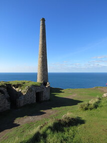
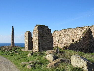 Ballarat Heritage Services
Photograph - Colour, Dorothy Wickham, St Just, Cornwall, World Heritage Site
A stone’s throw from Land’s End, this is the most westerly Area of the Site. St Just is characterised by big skies, jagged rocks, stark moorland, and iconic clifftop engine houses perched above the Atlantic in some incredible locations. No wonder this dramatic setting has inspired generations of artists, writers and photographers. World-famous for their mineralogy, the mining sites here are extremely well preserved – as is the sense of community amongst the people whose lives they once dominated. This Area’s unique geography and mineralogy meant that undersea mining was more concentrated here than anywhere else in the world in the 18th and 19th centuries. The oldest surviving Cornish beam engine (constructed in 1840) remains in its original engine house at Levant, restored and still working under steam. Geevor, one of the last mines to close in Cornwall (1990), was saved from demolition and is now the largest metalliferous mine site open to the public in the UK. The historic mining town of St Just is home to characteristic rows of granite mine workers’ cottages, public squares, shops, cafés, art galleries and, just off Bank Square, a medieval grassed amphitheatre – the Plen an Gwary or ‘playing place’.st just, world heritage,, ellis,, penrose, cornwall, mining, mines -
 Ballarat Heritage Services
Photograph - Colour, Dorothy Wickham, St Just, Cornwall, World Heritage Site
A stone’s throw from Land’s End, this is the most westerly Area of the Site. St Just is characterised by big skies, jagged rocks, stark moorland, and iconic clifftop engine houses perched above the Atlantic in some incredible locations. No wonder this dramatic setting has inspired generations of artists, writers and photographers. World-famous for their mineralogy, the mining sites here are extremely well preserved – as is the sense of community amongst the people whose lives they once dominated. This Area’s unique geography and mineralogy meant that undersea mining was more concentrated here than anywhere else in the world in the 18th and 19th centuries. The oldest surviving Cornish beam engine (constructed in 1840) remains in its original engine house at Levant, restored and still working under steam. Geevor, one of the last mines to close in Cornwall (1990), was saved from demolition and is now the largest metalliferous mine site open to the public in the UK. The historic mining town of St Just is home to characteristic rows of granite mine workers’ cottages, public squares, shops, cafés, art galleries and, just off Bank Square, a medieval grassed amphitheatre – the Plen an Gwary or ‘playing place’.st just, world heritage, ellis, penrose, cornwall, mining, mines