Showing 1378 items
matching state library victoria
-
 Kew Historical Society Inc
Plan - Subdivision Plan, Altyre Estate, 1920, 1920
... be found in other collections, such as those of the State Library... in 1920. A colour lithograph in the State Library of Victoria... in the State Library of Victoria, in contrast to this monochrome ...Pru Sanderson, in her groundbreaking ‘City of Kew Urban Conservation Study : Volume 2 - Development History’ (1988), summarised the periods of urban development and subdivisions of land in Kew. The periods that she identified included 1845-1880, 1880-1893, 1893-1921, 1921-1933, 1933-1943, and Post-War Development. These periods were selected as they represented periods of rapid growth or decline in urban development. An obvious starting point for Sanderson’s groupings involved population growth and the associated economic cycles. These cycles also highlighted urban expansion onto land that was predominantly rural, although in other cases it represented the decline and breakup of large estates. A number of the plans in the Kew Historical Society’s collection can also be found in other collections, such as those of the State Library of Victoria and the Boroondara Library Service. A number are however unique to the collection.The Kew Historical Society collection includes almost 100 subdivision plans pertaining to suburbs of the City of Melbourne. Most of these are of Kew, Kew East or Studley Park, although a smaller number are plans of Camberwell, Deepdene, Balwyn and Hawthorn. It is believed that the majority of the plans were gifted to the Society by persons connected with the real estate firm - J. R. Mathers and McMillan, 136 Cotham Road, Kew. The Plans in the collection are rarely in pristine form, being working plans on which the agent would write notes and record lots sold and the prices of these. The subdivision plans are historically significant examples of the growth of urban Melbourne from the beginning of the 20th Century up until the 1980s. A number of the plans are double-sided and often include a photograph on the reverse. A number of the latter are by noted photographers such as J.E. Barnes.The Altyre Estate was advertised for sale by auction in 1920. A colour lithograph in the State Library of Victoria, in contrast to this monochrome version, notes the proximity of the subdivision to the Auburn Heights Bowling Club and to a range of transport options. The subdivision included fifty-one allotments as well as the original house ‘Altyre’ in Barkers Road. This version includes the amounts paid as deposit on a number of lots.subdivision plans - kew, altyre estate – kew (vic), barkers road – kew (vic), walsh street – kew (vic), ross street – kew (vic), loxton street – kew (vic), mount street – kew (vic), auburn heights bowling club, altyre -
 Camberwell Historical Society
Postcard - Photo postcard, 1989
... Collection, State Library of Victoria. ... Trobe Collection, State Library of Victoria. Glossy black ...Glossy black and white photograph with white border on a postcard, depicting Burke Road dating around 1923. Photograph shows people crossing tram line surrounded by buildings, with horse and cart in the foreground.Back of postcard: Burke Road, Camberwell, c. 1923. La Trobe Collection, State Library of Victoria. -
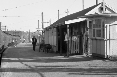 Greensborough Historical Society
Photograph - Photograph - Digital Image, A. E. Smith, Greensborough Station 1967, 1967
... on the right. Photographer: Smith, A. E. Source: State Library Victoria...: State Library Victoria. This photograph shows Greensborough ...A stationary Tait train along a curved platform at Greensborough railway station (1967) with the station building on the right. Photographer: Smith, A. E. Source: State Library Victoria. This photograph shows Greensborough Station before it was remodelled to a central "island" platform.Colour digital photograph.greensborough station -
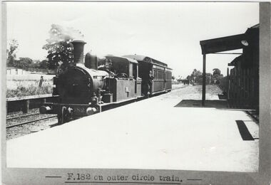 Kew Historical Society Inc
Print, F.182 on Outer Circle Train, circa 1928, c. 1905- c. 1928
... , sourced from the collection of the La Trobe Library, State Library... Library, State Library of Victoria, in the 1960s by Dorothy Rogers ...This work forms part of the collection assembled by the historian Dorothy Rogers, that was donated to the Kew Historical Society by her son John Rogers in 2015. The manuscripts, photographs, maps, and documents were sourced by her from both family and local collections or produced as references for her print publications. Many were directly used by Rogers in writing ‘Lovely Old Homes of Kew’ (1961) and 'A History of Kew' (1973), or the numerous articles on local history that she produced for suburban newspapers. Most of the photographs in the collection include detailed annotations in her hand. The Rogers Collection provides a comprehensive insight into the working habits of a historian in the 1960s and 1970s. Together it forms the largest privately-donated collection within the archives of the Kew Historical Society.A photographic copy of a train on the outer circle railway, sourced from the collection of the La Trobe Library, State Library of Victoria, in the 1960s by Dorothy Rogers while undertaking research for 'A History of Kew' (1973)."Outer Circle Railway. Supplied by La Trobe Library"outer circle railway, dorothy rogers -
 Clunes Museum
Artwork, other - LITHOGRAPH, S.T. GILL, MINER AT FRYERS CREEK, UNKNOWN
... FROM A PAINTING BY S.T. GILL. ORIGINAL IN STATE LIBRARY...FROM A PAINTING BY S.T. GILL. ORIGINAL IN STATE LIBRARY ...FROM A PAINTING BY S.T. GILL. ORIGINAL IN STATE LIBRARY OF VICTORIACOPY OF LITHOGRAPH OF A MINER AT FRYERS CREEK, MT. ALEXANDER DIGGINGSlocal history, illustration, lithograph, mining -
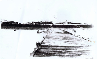 St Kilda Historical Society
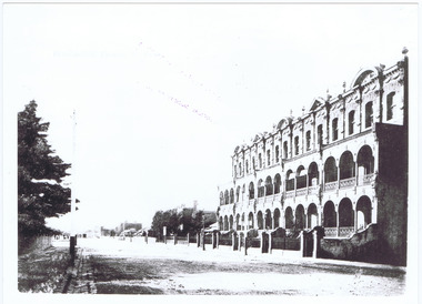
Photograph, St Kilda Pier
... Library of Victoria 11 May 1982 51002.... Pier. Copied by State Library of Victoria 11 May 1982 51002 ...Taken before arch at entrance was built. Esplanade in background.glossy black and white photograph fair conditionon back: Early picture St Kilda Pier. Copied by State Library of Victoria 11 May 1982 51002. -
 Kew Historical Society Inc
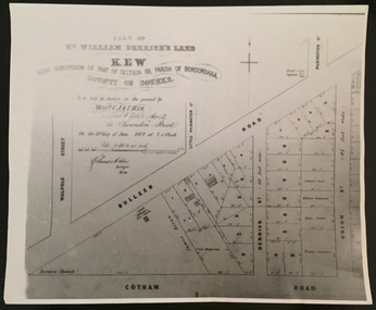
Plan - Framed Subdivision Plan (copy), F Price, Plan of Mr William Derrick's Land, Kew being Subdivision of Part of Section 86, Parish of Boroondara, County of Bourke, 1872, 1872
... in the State Library of Victoria....’. This is a copy of the plan held in the State Library of Victoria. Plan ...William Derrick was an early landowner in Kew, and with James Venn Morgan and James Dannock the purchaser of the parcel of land bounded by Cotham Road, High Street and Mary Street. Derrick Street in Kew is named after him.Map mounted under perspex. ‘Plan of Mr Willia Derrick's Land, Kew being Subdivision of Part of Section 86, Parish of Boroondara, County of Bourke’. This is a copy of the plan held in the State Library of Victoria.kew subdivision plan, john derrick, subdivision plans -- kew (vic.) -
Tarnagulla History Archive
Microfilm: Tarnagulla Courier/Tarnagulla & Llanelly Courier, 1992
... to 18.12.1869). Copied from State Library of Victoria holdings... from State Library of Victoria holdings - arranged and funded ...David Gordon Collection.A microfilm reel of Tarnagulla Courier (2nd Jan to 5th June 1869) and Tarnagulla & Llanelly Courier (12th June 1869 to 18.12.1869). Copied from State Library of Victoria holdings - arranged and funded by donor. -
Tarnagulla History Archive
Microfilm: Pages from the Tarnagulla Leader newspaper
... State Library of Victoria..... Microfilm copies obtained from State Library of Victoria. Microfilm ...David Gordon Collection. Microfilm copies obtained from State Library of Victoria. -
 Kew Historical Society Inc
Print - Subdivision Plan, F Price, Plan of Mr William Derrick's Land, Kew being Subdivision of Part of Section 86, Parish of Boroondara, County of Bourke, 1872, 1872 [Original]
... Collection of the State Library of Victoria showing William Derricks... reproduction of a plan in the Vale Collection of the State Library ...This work forms part of the collection assembled by the historian Dorothy Rogers, that was donated to the Kew Historical Society by her son John Rogers in 2015. The manuscripts, photographs, maps, and documents were sourced by her from both family and local collections or produced as references for her print publications. Many were directly used by Rogers in writing ‘Lovely Old Homes of Kew’ (1961) and 'A History of Kew' (1973), or the numerous articles on local history that she produced for suburban newspapers. Most of the photographs in the collection include detailed annotations in her hand.The Rogers Collection provides a comprehensive insight into the working habits of a historian in the 1960s and 1970s. Together it forms the largest privately-donated collection within the archives of the Kew Historical Society.A photographic reproduction of a plan in the Vale Collection of the State Library of Victoria showing William Derricks land in the area bordered by Bulleen Road (High Street); Cotham Road and Union Street. The plan dates from 1872.william derrick, subdivision plans -- kew (vic.) -
 Robin Boyd Foundation
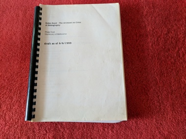
Book, Philip Goad, Robin Boyd - The Architect as Critic: A Bibliography, 1989
... to accompany the 1989 exhibition at State Library of Victoria... publication to accompany the 1989 exhibition at State Library ...Spiral Bound Typewritten manuscriptDraft (dated 6/6/1989) of catalogue publication to accompany the 1989 exhibition at State Library of Victoria of the same namerobin boyd, architecture, australia, bibliography, 20th century, walsh st library -
Glen Eira Historical Society
Article - Alma, Will
... at State Library of Victoria. Copy of the catalogue of the Alma... at State Library of Victoria. Leaflet produced by Will Alma ...This file contains eight items. Photocopy of a photograph of Will Alma and a WITH COMPLIMENTS card from Gail Evans at State Library of Victoria. Leaflet produced by Will Alma, undated, requesting public donations for the Alma Conjuring Collection at State Library of Victoria. Copy of the catalogue of the Alma Conjuring Collection at the State Library of Victoria dated January 1984. Photocopy of one page article from ANTIQUES AND ART, Vol. 1, Issue 1, year unknown, about the Alma Conjuring Collection. Photocopies of four photographs of the display at the Alma Conjuring Collection at the State Library of Victoria, photographer and date unknown. Copy of the Alma Magic Company mail order catalogue of 1934 of stage effect items from the Alma Conjuring Collection. Copy of the list of natal and pseudonyms of magicians from the Alma Conjuring Collection. Copy of the catalogue for an exhibition THE GREAT HOUDINI held at the State Library of Victoria from 15/10/1990 to 09/11/1990, featuring items from the Alma Conjuring Collection.alma will, alma conjuring collection, magicians, entertainment, sebastopol street, caulfield north, entertainment equipment -
 Bendigo Military Museum
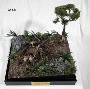
Memorabilia - DIORAMA, KOKODA, Post WW2
... Diorama inspired by image from State Library of Victoria... goldfields Diorama inspired by image from State Library of Victoria ...Diorama inspired by image from State Library of Victoria image No H98 104 / 2102.Diorama mounted on black base. 1/35 scale model of 25 pounder field gun with 5 man crew maneuvering a gun into position around a tree with a pulley system. In black print on gold name plate attached to front of black base:: “25 Pounder Field Gun 14th Australian Field Regiment, Kokoda, September 1942”military history-army, arms-ordnance, handcrafts, kokoda -
Federation University Historical Collection
Document - Folder, Archdeacon Joseph Best, History of the Diocese of Ballarat, 1898
... From the State Library of Victoria LaTrobe Collection MS... the State Library of Victoria LaTrobe Collection MS 11840 Box 2178/6 ...From the State Library of Victoria LaTrobe Collection MS 11840 Box 2178/6 Folder of research notes the history of the Anglican Diocese of Ballarat anglican diocese of ballarat, st john's ballarat, joseph best, dianne campbell goldfields lawyers collection, a.l. lynn, edward charles moore, captain moonlight -
 Federation University Historical Collection
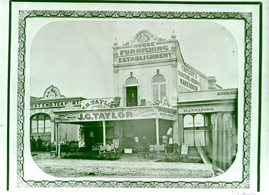
Photograph - Photograph - Black and White, Sturt Street, Ballarat, 1861, 1861
... Library of Victoria, and copied by Keith Rash, c1970... The photograph is a copy of an item held by the State Library of Victoria ...The photograph is a copy of an item held by the State Library of Victoria, and copied by Keith Rash, c1970Black and White photograph of Sturt Street, Ballarat showing three shops: The West End Tea Mart, the double storey Taylor's Furniture and Bedding Warehouse, and Hannaford Bookseller. j.g. taylor, taylor's furniture and bedding warehouse, hannaford bookseller, west end tea mart, a.r. hall, sturt street, ballarat -
 Robin Boyd Foundation
Document - Receipt, La Trobe Library Manuscripts Collections, 08.02.1996
... to Robin Boyd given to the State Library of Victoria... to Robin Boyd given to the State Library of Victoria A fille ...This is a receipt for five boxes of manuscripts related to Robin Boyd given to the State Library of VictoriaA fille- in form with blue handwriting -
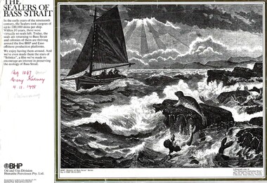 Phillip Island and District Historical Society Inc.
Print, The sealers of Bass Strait, 1972
... . From the La Trobe Collection, State Library, Victoria. BHP Oil... Library, Victoria. BHP Oil and Gas Division Hematite Petroleum Pty ...No. 9 'The Sealers". BHP "History of Bass Strait"Series. Lithograph copy in 'The Illustrated Australian News", May 4th 1881. From the La Trobe Collection, State Library, Victoria. BHP Oil and Gas Division Hematite Petroleum Pty. Ltd. From The Australian Financial Review, 15 Sep 1972HistoricalLarge, black & white lithograph of sailing vessel in rough seas showing seals and rocks, with typed explanation. In the early of the nineteenth century, The sealers took cargoes of up to 100,000 skins per ship. Within 10 years, there were virtually no seals left. Today, the seals are returning to Bass Strait and colonies of them are thriving around the five BHP and Esso offshore production platforms. We enjoy having them around. And we've even made them the stars of "Solstice", a film we've made to encourage an interest in preserving the ecology of Bass Strait.sealing, westernport bay, broken hill proprietary ltd. -
Glen Eira Historical Society
Document - Cavers Carre
... /1884 and unknown from State Library Victoria records.... and Riddell Estate dated 29/11/1884 and unknown from State Library ...Three articles about Cavers Carre. Handwritten document giving details of the location of the house. Built c.1866 and demolished prior to 1905 when the block was subdivided. No details of the house. Two plans of Gardenvale and Riddell Estate dated 29/11/1884 and unknown from State Library Victoria records.gardenvale estate, glen huntly road, riddell estate, melbourne and brighton railway, mcmillan street, orrong road, archibald street, rowan street, hamilton street, downshire road, shoobra road, madden walter, tuxen august, fraser and co., surveyors, muntz and muntz, cavers carre, elsternwick, stanley street, carre street, railway cresent, riddell parade, riddell john carre, land subdivisions -
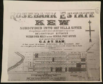 Kew Historical Society Inc
Plan - Subdivision Plan, Rosebank Estate, Kew
... of a plan in the Vale Collection of the State Library of Victoria... in the Vale Collection of the State Library of Victoria made ...This work forms part of the collection assembled by the historian Dorothy Rogers, that was donated to the Kew Historical Society by her son John Rogers in 2015. The manuscripts, photographs, maps, and documents were sourced by her from both family and local collections or produced as references for her print publications. Many were directly used by Rogers in writing ‘Lovely Old Homes of Kew’ (1961) and 'A History of Kew' (1973), or the numerous articles on local history that she produced for suburban newspapers. Most of the photographs in the collection include detailed annotations in her hand. The Rogers Collection provides a comprehensive insight into the working habits of a historian in the 1960s and 1970s. Together it forms the largest privately-donated collection within the archives of the Kew Historical Society.Rosebank Estate (Kew). A photographic reproduction of a plan in the Vale Collection of the State Library of Victoria made for the historian Dorothy Rogers. This plan is a later version of the original subdivision plan after a number of lots had been sold.rosebank estate (kew), studley park, thomas ham, c.j. & t. ham, rosebank estate, kew, wills street, barry street, fellows street, redmond street, molesworth street, thomas wills, wills family -
 Eltham District Historical Society Inc
Photograph, Eltham, Victoria, c.1914-1918, 1910s
... Photo print possibly sourced from the State Library... melbourne Photo print possibly sourced from the State Library ...Photo print possibly sourced from the State Library of Victoria. Date based on other images in the series. Copy of black and white photograph -
 Robin Boyd Foundation
Slide, Robin Boyd
... by photographer Lyle Fowler and are held in the State Library of Victoria... by photographer Lyle Fowler and are held in the State Library of Victoria ...The original images of Clendon Flats are taken by photographer Lyle Fowler and are held in the State Library of Victoria collection.Colour slide in a mount. Magazine image, Clendon Flats, Armadale (1940), Melbourne, Victoria, Australia (Architect: Roy Grounds)Made in Australia / G4 (Handwritten)slide, robin boyd -
 Robin Boyd Foundation
Slide, Robin Boyd
... by photographer Lyle Fowler and are held in the State Library of Victoria... by photographer Lyle Fowler and are held in the State Library of Victoria ...The original images of Clendon Flats are taken by photographer Lyle Fowler and are held in the State Library of Victoria collection.Colour slide in a mount. Magazine image, Underside of deck, Clendon Flats, Armadale (1940), Melbourne, Victoria, Australia. (Architect: Roy Grounds)Made in Australia / G2 (Handwritten-Cancelled) / 27 (Handwritten-Cancelled) / Encircled 5 (Handwritten)slide, robin boyd -
Healesville Sanctuary Heritage Centre
Newspaper - Cutting, The Age, Melbourne, Sanctuary at Healesville, 10 May 1955
... time. Collected from State Library Melbourne Victoria... time. Collected from State Library Melbourne Victoria 1950s ...Comparison of Sanctuary in its early days to the present time. Collected from State Library Melbourne Victoriaphotocopy 1950s -
University of Melbourne, Burnley Campus Archives
Plan, Plan of the Zoological and Acclimatisation Society of Victoria, Royal Park, Melbourne, c. 1884
... Copy of plan held at the State Library of Victoria surveyed.... purchas Copy of plan held at the State Library of Victoria ...Copy of plan held at the State Library of Victoria surveyed by G. Purchas, possibly 1884. Possibly based on the winning competition entry by Alfred Lynch 1861 (See B17.0076). Also see B18.0030 Plan drawn by Caroline Le Souef.caroline le souef, alfred lynch, zoological and acclimatisation society of victoria, royal park, g. purchas -
 Bendigo Historical Society Inc.
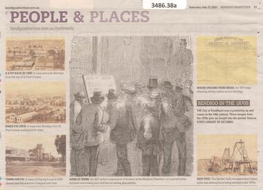
Newspaper - Article on People and Places, Sat July 17 2021
... in the 19th century. Images are from the 1870s from the state Library... in the 19th century. Images are from the 1870s from the state Library ...The City of Sandhurst was a promising up and comer in the 19th century. Images are from the 1870s from the state Library of Victoria.Bendigo Advertiser Article entitled 'People and Places' - five historical photos of views over Bendigo and an artist's impression of brokers at the Beehive chambers.bendigo history -
 Eltham District Historical Society Inc
Photograph, St. Andrews Hotel, c.1910
... Library of Victoria.... Original glass plate negative held by State Library of Victoria ...Black and white copy of photo printed on glossy photographic paper 30.5 x 40.5 cm (12 x 16 inch); image size approx. 18.5 x 28 cmOriginal photo appears to be a copy from a newspaper or illustrated print article. Original glass plate negative held by State Library of Victoriaqueenstown, st. andrews, st. andrews hotel -
 St Kilda Historical Society
Photograph, Queen's Mansions, Beaconsfield Parade
... label stuck on back: Copied by State Library of Victoria 11... by State Library of Victoria 11 May 1982 51002, Another label ...copy of black and white photograph, unmounted, glossy, poor conditionlabel stuck on back: Copied by State Library of Victoria 11 May 1982 51002, Another label: Queens Mansions, Beaconsfield Parade -
 Kew Historical Society Inc
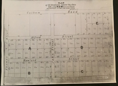
Plan - Subdivision Plan, Plan of 68 beautifully situated villa sites: St Helliers Kew, 196-1973
... Collection of the State Library of Victoria. The plan shows lots... reproduction of a plan in the Vale Collection of the State Library ...This work forms part of the collection assembled by the historian Dorothy Rogers, that was donated to the Kew Historical Society by her son John Rogers in 2015. The manuscripts, photographs, maps, and documents were sourced by her from both family and local collections or produced as references for her print publications. Many were directly used by Rogers in writing ‘Lovely Old Homes of Kew’ (1961) and 'A History of Kew' (1973), or the numerous articles on local history that she produced for suburban newspapers. Most of the photographs in the collection include detailed annotations in her hand. The Rogers Collection provides a comprehensive insight into the working habits of a historian in the 1960s and 1970s. Together it forms the largest privately-donated collection within the archives of the Kew Historical Society.A photographic reproduction of a plan in the Vale Collection of the State Library of Victoria. The plan shows lots in a subdivision bordered by Cotham Road; Edward Street; Sackville Street and Thomas Street. The undated plan does not include the land occupied by Bella Vista and Charleville.subdivision plans -- kew (vic), st helliers estate -
 Greensborough Historical Society
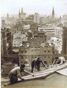
Photograph - Digital image, Workers removing blackout sheets from SLV Dome with Melbourne skyline in background, 1947, 1947_
... material from the State Library of Victoria Dome in 1947... removing the blackout material from the State Library of Victoria ...This photograph shows workers removing the blackout material from the State Library of Victoria Dome in 1947. The Melbourne skyline is in the background.This is a copy of one of the photographs donated to the SLV by GHS member Rex Smith in 2003.Digital copy of black and white photograph.rex smith -
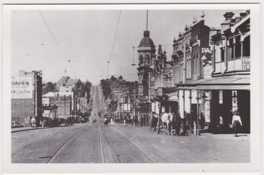
 Ballarat Tramway Museum
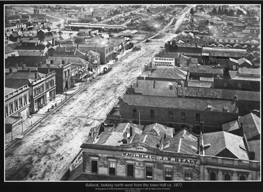
Photograph - Black & White copy, William Bardell, "Ballarat looking north west from the Town Hall ca 1872"
... image held by the State Library of Victoria. Edited by Richard... Library of Victoria. Edited by Richard Conn. Purchased ...Original photograph by William Bardwell, with the original image held by the State Library of Victoria. Edited by Richard Conn. Purchased by the Museum.Provides information about the appearance of Armstrong St from the Town Hall. Shows the topography of the area, along with many buildings, including W Milne & Cp and J N Healy in the Hall of Commerce and Doig & Co, Plumbers and Gasfitters.Black & White copy photograph aerial view A4 size, titled ""Ballarat looking north west from the Town Hall ca 1872" looking along Armstrong St. Original photo by William Bardwell.ballarat, armstrong st, w milne & co, doig&co, j n healy