Showing 652 items
matching survey department
-
 Port Melbourne Historical & Preservation Society
Photograph - Aerial view showing route of Lower Yarra Crossing Project (West Gate Bridge), Apr 1966
... Department of Lands and Survey... (West Gate Bridge) Department of Lands and Survey ...Black and white aerial photomap showing the proposed route of the Lower Yarra Crossing Project, later to become the West Gate Bridge and Freeway. April 1966'Lower Yarra Crossing Project' '296769'west gate bridge, transport - roads, engineering - bridges -
Port Melbourne Historical & Preservation Society
Map - Melbourne and suburbs, Department of Lands and Survey, 1 May 1934
... Department of Lands and Survey... sights Map Melbourne and suburbs Department of Lands and Survey ...Large printed map of Melbourne and suburbs 1936 showing historic sightsmelbourne, south melbourne, transport - tramways, transport - railways -
Port Melbourne Historical & Preservation Society
Map - City of Port Melbourne, Department of Lands and Survey, 29 Nov 1938
... Department of Lands and Survey...). 1938 Map City of Port Melbourne Department of Lands and Survey ...Printed map of City of Port Melbourne - Fishermens Bend area and down to Williamstown Road (Kitchens etc). 1938Red pencil marks through existing Lorimer St (refer 306)built environment - industrial, health - general health, fishermans bend, j kitchen & sons pty ltd -
Port Melbourne Historical & Preservation Society
Letter - re Site of Sandridge Municipal Council Chambers, 5 Oct 1860
... department of lands and survey... - zoning department of lands and survey clement hodgkinson ...Handwritten letter advising of the proclamation of the site for Municipal Council Chambers at Sandridge 5th October 1860local government - municipal district of sandridge, built environment - zoning, department of lands and survey, clement hodgkinson -
Port Melbourne Historical & Preservation Society
Letter - Department of Lands and Survey granting land for temporary reserve, 18 Mar 1860
... Department of Lands and Survey granting land for temporary... government - borough of sandridge industry - noxious department ...Handwritten letter from Dept of Lands and Survey granting Crown land for temporary reserve as site for abattoirs 18 March 1861local government - borough of sandridge, industry - noxious, department of lands and surveys, clement hodgkinson -
Port Melbourne Historical & Preservation Society
Letter - Department of Lands and Survey grant for improving public parks in Sandridge, Department of Lands and Survey, 19 Oct 1863
... Department of Lands and Survey grant for improving public...Department of Lands and Survey... Department of Lands and Survey ...Handwritten letter from Dept of Lands and Survey 19.10.1863, notifying grant of £90/0/0 for the improving of public parks in Sandridge for 1863local government - borough of sandridge -
Port Melbourne Historical & Preservation Society
Letter - Department of Lands and Survey reply re setting out Sandridge streets, Department of Lands and Survey, 30 Jan 1861
... Department of Lands and Survey reply re setting out...Department of Lands and Survey... Department of Lands and Survey reply re setting out Sandridge streets ...Handwritten letter on blue foolscap laid paper, from Dept of Lands and Survey 13.1.1861 replying to Town Clerk's request on setting out Sandridge streetslocal government - borough of sandridge -
Port Melbourne Historical & Preservation Society
Letter - Department of Lands and Survey re notification of crown grants for Sandridge municipal chambers and market site, Department of Lands and Survey, 20 Jun 1862
... Department of Lands and Survey re notification of crown...Department of Lands and Survey... Letter Department of Lands and Survey re notification of crown ...Handwritten letter on blue foolscap laid paper, from Dept of Lands and Survey 20.6.1862 notifying Town Clerk of two crown grants, for municpal chambers and for market site. Paper watermarked A.Cowan & Sons 1855Notations in pencil on back, upper leftlocal government - borough of sandridge, market reserve, port melbourne town hall -
Port Melbourne Historical & Preservation Society
Letter - Department of Lands and Survey re proclaimation of Beach Street, Sandridge, Department of Lands and Survey, 16 Mar 1861
... Department of Lands and Survey re proclaimation of Beach...Department of Lands and Survey... Department of Lands and Survey ...Handwritten letter on blue foolscap laid paper, from Dept of Lands and Survey 16.3.1861, directing attention to proclamation in Government Gazette re Beech Street (sic) Sandridgelocal government - borough of sandridge, engineering - roads streets lanes and footpaths -
Port Melbourne Historical & Preservation Society
Letter - Department of Lands and Survey re proclaimation for site of Town Hall, Sandridge, Department of Lands and Survey, 30 Dec 1861
... Department of Lands and Survey re proclaimation for site of...Department of Lands and Survey... Department of Lands and Survey ...Handwritten letter on blue foolscap laid paper, from Dept of Lands and Survey 30.12.1861 directing attention to proclamation in Government Gazette re site for Town Hall at Sandridge. Paper, watermarked with Britannia symbollocal government - borough of sandridge, port melbourne town hall -
Port Melbourne Historical & Preservation Society
Letter - Department of Lands and Survey re proclaimation for site of Sandridge municipal common, Department of Lands and Survey, 10 Oct 1863
... Department of Lands and Survey re proclaimation for site of...Department of Lands and Survey..., watermarked TH Saunders 1862 Letter Department of Lands and Survey re ...Handwritten letter on blue foolscap laid paper, from Dept of Lands and Survey 10.10.1863, directing attention to proclamation in Government Gazette re site for Sandridge municipal common. Paper, watermarked TH Saunders 1862local government - borough of sandridge, port melbourne town hall -
Bendigo Historical Society Inc.
Booklet - Bendigo Goldfield, Geological Survey Report No 93
Soft cover booklet of 50 pages. Geological Survey Report No 93. Bendigo Goldfield. Spring Gully, Golden Square, Eaglehawk By C.E. Willman and H.E.Wilkinson. Colour photo of the North Deborah mine poppet-head on a pale-yellow front cover. Illustrated with B&W photos, maps and sketches. Published 1992 by the Department of Manufacturing and Industry Development , Victoria Errata page pasted inside front cover. M & J Qualtrough sticker on title page. bendigo goldfield, geological survey -
 Bendigo Historical Society Inc.
Map - JACK FLYNN MAP COLLECTION: GLADSTONE AND BENDIGO - TARNAGULLA, 13th May 1922
... . Photo-Lithographed at the Department of Lands and Survey.... Photo-Lithographed at the Department of Lands and Survey ...Map 388. Counties of Gladstone and Bendigo a Map of Tarnagulla with Kingower, Glenalbyn, Inglewood, Waanyarra and Laanecoorie boarding. The map is in poor condition and in several pieces. It has been previously taped together. The front page is of red card with white tape along the spine to hold it together, top half Tarnagulla is hand written in black lead on a label with blue trim.By Authority A.J. Mullett, Government Printer, Melbourne. Photo-Lithographed at the Department of Lands and Survey, Melbourne by W.J. Butson. 13.5.22map, bendigo, tarnagulla, tarnagulla, kingower, glenalbyn, laanecoorie, inglewood. -
 Bendigo Historical Society Inc.
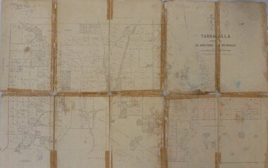
Document - LONG GULLY HISTORY GROUP COLLECTION: THE BENDIGO POST OFFICE
Article titled The Bendigo Post Office, compiled by L C Bennetts. Mentioned is the history of the Bendigo Post Office and postmarks, some information on mining, Bendigo foundries, Underground connections of mines, expenses and shaft sinking costs. Also mentioned is Bendigo and Eaglehawk - 60 years ago and the role the pubs played in daily living. They were where theatres, concerts and dances were held, and the meeting rooms for clubs and lodges, even church benefits. Listed is a number of Bendigo hotels. Some even had a few names. Names of the pubs are: The Freemasons, The Courthouse, The Commercial Law Courts, The Hamburg, The European, The Prince Bismark, The Lord Kitchener, The Bendigo, The Rosalind Park, The Showgrounds, Atheneum Club, Olivers, Bridge Hotel, Bourkes, The Globe, The Hibernia, Albert, Albion, Abbotts, Australian, Belvidere, Beehive, British Queen, Black Eagle, British and American, Brian Boru, Bakers Arms, Butchers Arms, Brick Layers Arms, Bull and Mouth, Cresent, Clarence, Back Creek Bridge, Cape Clear, Crooked Billet, Cambridgeshire Arms, Camp, Coach and Horses, Cricketers Arms, Diggers Rest, Ellesmere, Five Lions, Franklyn, Golden Square, Golden Gate, Golden Gully, Golden Age, Golden Vine, Gumtree, Glasgow Reef, Great Britain, Haymarket, Daniel O'Connell, Half Way House, Fleece Inn, Ironbark, Johnsons Reef, Lancashire, Live and Let Live, Manchester Arms, Gold Mines, Metropolitan, Crown, National, New Chum, Honeysuckle Street, Pavilion, Napier Arms, Quartz Miners Arms, Retreat Inn, Rainbow, Rose of Australia, Lake View, Robin Hood, Fountain, Southern Cross, Bath, Berlin, Spring Gully, Star, Sir Charles Hotham, Silvermines, Royal Oak, Suburban, Town Hall, Temperance, Ship Inn, View Point, View Bend, Victoria, Exchange, American, Arcade, Belfast, All Nations, Union, United Kingdom, Union Jack, Westend, Washington, Waterloo, Wellington, Whitehorse, Wheat Sheaf, Yorkshire, Niagra and Noahs Ark.bendigo, history, long gully history group, the long gully history group - the bendigo post office, l c bennetts, mt alexander post office, porcupine inn, cenotaph, pike or pyke, baby health centre, sandhurst post office, government survey office, queen elizabeth oval, sandhurst trustees company, mr h b briston, savings bank, telegraph office, the sub-treasury, sir henry brougham lock kcb, sir john nimmo mla, prince of wales group of mines, the new prince of wales, eaglehawk golf links, new prince of wales no 2, the whip and jersey, mines department, lansell's big 180, new chum and victoria mine and battery, new chum railway, koch's pioneer, south new moon, catherine reef united, new moon, the virginia, south bell vue, central nell gwynne, north nell gwynne, miner's phthisis, hercules engine house, ironbark, new chum syncline, hercules energetic, roberts & sons, harkness & co, horwoods, great southern, ulster, carlisle, lansells big 180, victoria quartz, new st mungo, duchess tribute, south devonshire, hopewell mine, saxby mine, mcnair & co, shamrock, mr king, burke and wills expedition, sandhurst hotel, courthouse, hiberian, the freemasons, the courthouse, the commercial law courts, the hamburg, the european, the prince bismark, the lord kitchener, the bendigo, the rosalind park, the showgrounds, atheneum club, olivers, bridge hotel, bourkes, the globe, the hibernia, albert, albion, abbotts, australian, belvidere, beehive, british queen, black eagle, british and american, brian boru, bakers arms, butchers arms, brick layers arms, bull and mouth, cresent, clarence, back creek bridge, cape clear, crooked billet, cambridgeshire arms, camp, coach and horses, cricketers arms, diggers rest, ellesmere, five lions, franklyn, golden square, golden gate, golden gully, golden age, golden vine, gumtree, glasgow reef, great britain, haymarket, daniel o'connell, half way house, fleece inn, ironbark, johnsons reef, lancashire, live and let live, manchester arms, gold mines, metropolitan, crown, national, new chum, honeysuckle street, pavilion, napier arms, quartz miners arms, retreat inn, rainbow, rose of australia, lake view, robin hood, fountain, southern cross, bath, berlin, spring gully, star, sir charles hotham, silvermines, royal oak, suburban, town hall, temperance, ship inn, view point, view bend, victoria, exchange, american, arcade, belfast, all nations, union, united kingdom, union jack, westend, washington, waterloo, wellington, whitehorse, wheat sheaf, yorkshire, niagra, noahs ark -
Bendigo Historical Society Inc.
Map - GEOLOGICAL MAP OF BENDIGO GOLD FIELD
Two framed laminated maps (a,b) of Bendigo goldfield reef lines, map (b) is a continuation of the reef lines in map (a). On map(a) written in black on top: 'Geological Map, Bendigo Gold Field', Scale of chains, anticlines, synclines, shafts, alluvial and contours marked. Map (b) is continuation of (a). Written on the bottom RH corner of map: 'Prepared in 1923 in the Bendigo Office Mines Department under the direction of H. Herman, Director of Geological Surveys, from surveys by H.S. Whitelaw, Fiield Geologist, assisted by E.S. Usher & J. J. Moore. Re-issued in 1936.'H. Herman, Director of Geological Surveys, from surveys by H.S. Whitelaw, Fiield Geologist, assisted by E.S. Usher & J. J. Moore. Re-issued in 1936.'bendigo, mining, geological map. -
Bendigo Historical Society Inc.
Document - HARRY BIGGS COLLECTION: OLD POLICE BARRACKS, 5/6/70
Document. Harry Biggs Collection. A letter on Public Works Department Victoria letterhead from G. Serpell Director General to Mr H. Biggs, Treasurer Royal Historical of Victoria (Bendigo Branch) dated 5th June 1970. In the letter he is stating The Depart. Of Crown Lands & Survey is investigating the future use & control of the old Police Barracks building.G. Serpell Director Generalorganization, club/society, community, harry biggs collection, old police barracks -
 Bendigo Historical Society Inc.
Map - JACK FLYNN COLLECTION: TARNAGULLA SHEET 4, 25/11/1926
... Photo-Lithographed at the Department of lands and Survey... at the Department of lands and Survey, Melbourne by W. J. Butson. 25.11.26 ...Map: Parish of Tarnagulla Sheet 4, Counties of Gladstone and Bendigo. Parish plan.Photo-Lithographed at the Department of lands and Survey, Melbourne by W. J. Butson. 25.11.26map, gladstone, parish plan, tarnagulla sheet 4 -
 Bendigo Historical Society Inc.
Map - JACK FLYNN COLLECTION: TARNAGULLA, 13/05/1922
... . Lithographed at the Department of Lands and Survey, Melbourne by W. J..., Government Printer, Melbourne. Lithographed at the Department ...Map: Parish of Tarnagulla . This Item is in very poor condition.By Authority, A. J. Mullen, Government Printer, Melbourne. Lithographed at the Department of Lands and Survey, Melbourne by W. J. Butsonmap, gladstone, parish plan, tarnagulla -
 Bendigo Historical Society Inc.
Map - JACK FLYNN COLLECTION: SALISBURY, 1965
... . Drawn and Reproduced at the Department of Lands and Survey... Printer, Melbourne. Drawn and Reproduced at the Department ...Map: Parish of Salisbury, County of Bendigo. Parish plan.By Authority A. C. Brooks Government Printer, Melbourne. Drawn and Reproduced at the Department of Lands and Survey, Melbourne.map, bendigo, parish plan, salisbury -
 Bendigo Historical Society Inc.
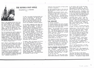
Map - JACK FLYNN COLLECTION: RAVENSWOOD, 12/12/1922
... . Photo Lithographed at the Department of lands and Survey... Printer Melbourne. Photo Lithographed at the Department of lands ...Map: Parish of Ravenswood, Counties of Bendigo and Talbot. Parish plan.By Authority A.J. Mullet Government Printer Melbourne. Photo Lithographed at the Department of lands and Survey, Melbourne by W.J. Butsonmap, bendigo, parish plan, ravenswood -
 Bendigo Historical Society Inc.
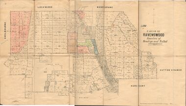
Map - JACK FLYNN COLLECTION: NEILBOROUGH, 13/10/1927
... Photo Lithographed at the Department of Lands and Survey... at the Department of Lands and Survey, Melbourne by W.J. Butson Map: Parish ...Map: Parish of Neilborough, County of Bendigo. Parish plan.Photo Lithographed at the Department of Lands and Survey, Melbourne by W.J. Butsonmap, bendigo, parish plan, neilborough -
 Bendigo Historical Society Inc.
Map - JACK FLYNN COLLECTION: MUSKERRY, 1962
... . Drawn and reproduced at the Department of Lands and Survey... Printer, Melbourne. Drawn and reproduced at the Department ...Map: Parish of Muskerry, County of Rodney. Parish plan.By Authority: A.C. Brooks, Government Printer, Melbourne. Drawn and reproduced at the Department of Lands and Survey, Melbournemap, rodney, parish plan, muskerry -
 Bendigo Historical Society Inc.
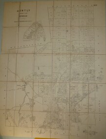
Map - JACK FLYNN COLLECTION: HUNTLY, 8/09/1921
... Lithographed at the Department of Land and Survey Melbourne By W. J.... Mullett. Photo Lithographed at the Department of Land and Survey ...Map: Parish of Huntly, County of Bendigo. Parish plan.By Authority, Govt., Printer. A. J. Mullett. Photo Lithographed at the Department of Land and Survey Melbourne By W. J. Butsonmap, bendigo, parish plan, huntly -
 Bendigo Historical Society Inc.
Map - JACK FLYNN COLLECTION: GIRGARRE, 1957
... . Drawn and reproduced at the Department of Lands and Survey... Printer, Melbourne. Drawn and reproduced at the Department ...Map: Township of Girgarre, Parish of Kyabram, County of Rodney. Parish plan.By Authority: W. M. Houston, Government Printer, Melbourne. Drawn and reproduced at the Department of Lands and Survey, Melbourne.map, rodney, township, girgarre -
 Bendigo Historical Society Inc.
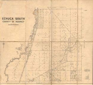
Map - JACK FLYNN COLLECTION: ECHUCA SOUTH, 13/08/1931
... By Authority H. J. Green, Govt. Printer. Department.... J. Green, Govt. Printer. Department of Lands and Survey ...Map: Parish of Echuca South, County of Rodney. Parish plan.By Authority H. J. Green, Govt. Printer. Department of Lands and Survey, Melbourne. 13.8.31map, rodney, parish plan, echuca south , county of rodney -
 Bendigo Historical Society Inc.
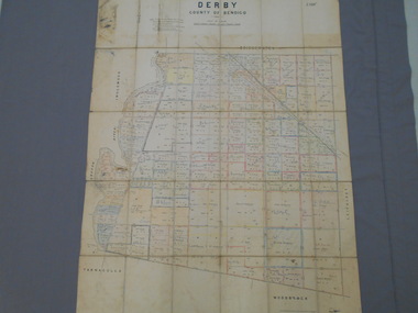
Map - JACK FLYNN COLLECTION: DERBY, 12/05/1892
... Department of Lands and Survey Melbourne by T.F.McGauran... Bendigo parish plan Derby Department of Lands and Survey Melbourne ...Map: Derby, County of Bendigo. Parish plan.Department of Lands and Survey Melbourne by T.F.McGauran, 12.5.92map, bendigo, parish plan, derby -
 Bendigo Historical Society Inc.
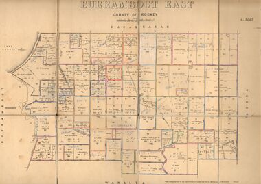
Map - JACK FLYNN COLLECTION: BURRUMBOOT EAST, 21/12/1027
... Photo Lithographed at the Department of Lands and Survey... at the Department of Lands and Survey, Melbourne by W.J.Butson. 21.12.27 Map ...Map: Burrumboot East, County of Rodney. Parish plan.Photo Lithographed at the Department of Lands and Survey, Melbourne by W.J.Butson. 21.12.27map, rodney, parish plan, burrumboot east -
 Bendigo Historical Society Inc.
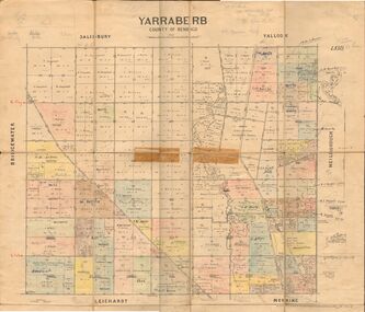
Map - JACK FLYNN COLLECTION: YARRABERB, 2/03/1931
... at the Department of lands and Survey Melbourne, 2.3.31....., Printer. Photo Lithographed at the Department of lands and Survey ...Map: Yarraberb, County of Bendigo. Parish plan.By Authority H.J. Green Govt., Printer. Photo Lithographed at the Department of lands and Survey Melbourne, 2.3.31.map, bendigo, parish plan, yarraberb -
 Bendigo Historical Society Inc.
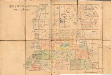
Map - JACK FLYNN COLLECTION: BRIDGEWATER, 6/10/1927
... Photo Lithographed at the Department of Lands and Survey... at the Department of Lands and Survey, Melbourne by W.J. Butson. Map ...Map: Bridgewater , County of Bendigo. Parish plan.Photo Lithographed at the Department of Lands and Survey, Melbourne by W.J. Butson.map, bendigo, parish plan, bridgewater -
 Bendigo Historical Society Inc.
Map - JACK FLYNN COLLECTION: BURNEWANG, 17/09/1918
... Melbourne. Photo Lithographed at the Department of Lands and Survey... at the Department of Lands and Survey, Melbourne by W. J. Butson. Map ...Map: Parish of Burnewang, County of Rodney. Parish plan.By Authority, H. J. Green, Acting Government Printer Melbourne. Photo Lithographed at the Department of Lands and Survey, Melbourne by W. J. Butson.map, rodney, parish plan, burnewang, rodney