Showing 405 items
matching topography
-
 Lakes Entrance Regional Historical Society (operating as Lakes Entrance History Centre & Museum)
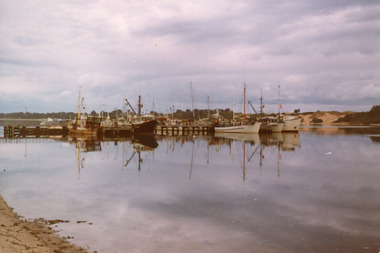
Photograph, Holding George, 1978
Color photograph of the Bank Jetty. It shows some of the fishing fleet, including scallop boats and trawlers moored on either side of the jetty, southern shore of Cunninghame Arm in background. Reflections of boats in calm waters of the lake. Lakes Entrance VictoriaBank Jetty before new construction in concrete (on back)jetties, waterfront, fishing industry, topography -
 Lakes Entrance Regional Historical Society (operating as Lakes Entrance History Centre & Museum)
Postcard, 1910c
Note on back to Miss Barber from Betty saying she asked Mrs Blay about accommodation etc.Sepia toned postcard showing Albert Park Guest House consisting of bedroom wing on left and detached kitchen dining wing on right, verandah across front of building with two deck chairs and bench on verandah, man and lady standing and lady sitting on bench. Extensive paths and garden in front, glimpses of other buildings at back. Two water tanks at left one round galvanized and one square, trees behind building. Lake Tyers VictoriaAlbert Park Lake Tyers Victoriawaterways, natural disasters, public utilities, topography -
Lakes Entrance Regional Historical Society (operating as Lakes Entrance History Centre & Museum)
Photograph, Gippsland Ports, 2006 c
Colour aerial photograph showing the entrance to Gippsland Lakes from Bass Strait westward to Reeves Channel Shaving Point at Metung through Lake King to Tambo River Gippsland Lakes Victoriaaerial photograph, waterways, township, topography -
Lakes Entrance Regional Historical Society (operating as Lakes Entrance History Centre & Museum)
Photograph, Gippsland Ports, 2006 c
Colour aerial photograph showing Shaving Point at Metung including Chinamans Creek at the right housing subdivisions of Kingscove Estate Tambo Bluff Estate and Lake King on Gippsland Lakes Victoriaaerial photograph, topography, the entrance, waterways -
Lakes Entrance Regional Historical Society (operating as Lakes Entrance History Centre & Museum)
Photograph, 1995 c
Colour aerial photograph of Shaving Point Gippsland Lakes with Mosquito Point bottom left hand corner Boole Poole on opposite shore Metung Victoriaaerial photograph, waterways, the entrance, topography -
Lakes Entrance Regional Historical Society (operating as Lakes Entrance History Centre & Museum)
Photograph, Tidy Town Committee, 1996 c
Also a second similar photograph number 03875.1 size 10 x 15 cmColour photograph taken from Jemmys Point looking west through the Gippsland Lakes to Metung with Rigby, Fraser and Flannagan Islands to the south Kalimna Victoriaaerial photograph, township, topography, waterways -
 Eltham District Historical Society Inc
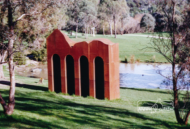
Photograph, Sculpture 'Classical Landscape' by Cliff Burtt, Alistair Knox Park, Eltham
Iron sculpture by Cliff Burtt welcomes visitors to the Gateway of Eltham. It was constructed of Corten Steel in 1994 and won the Eltham Public Art Award in 1996. “Award winning sculptor, Cliff Burtt, often references the geometry of architectural forms in his bold, minimalist public sculptures. In this corten steel work the repeated arches of the temples of antiquity are in dialogue with the nearby spans of the railway trestle bridge that cuts through the Eltham parkland. The formality of the architecture is offset by the organic sweeps of the top profile of the work, which playfully acknowledges the hilly topography of the region” – Highlights from the Nillumbik Art Collection Two colour photographs of iron sculptureclassical landscape, sculptures, art, parks, alistair knox park, eltham, cliff burtt, public art -
Federation University Historical Collection
Map - Plan, Ballarat Deep Leads and Mines, 1992, 1992
This is Bulletin No. 62: Deep Lead Gold Deposits in Victoria. Map No.6 Ballarat Sheet 1 of 2 The map shows geology, topography and information on mines in the following areas: one large map of the Ballarat area with five enlargements for: Sago Hill District; Scarsdale District; Pitfield Plains District; Berringa Gold Field and Rokewood District. Ballarat Mines and Deep Leads Report No.94 (Finlay and Douglas,1992) provides a summary of the Geological Survey of Victoria mines database, references and geology for most of the mines on this map. Geology Compilation: simplified from earlier Departmental mapping with minor field checking by E.N.M. Plier-Malone. Very large rectangular sheet of paper with seven coloured maps of various sizes and a small green rectangle on the bottom rhs with a map of Victoria superimposed over a poppet head. this rectangle includes information of the other maps shown. The background for these maps is white. Also includes tables of names of mine companies, name of shafts and gold production.gold mines of australia, gold mines of victoria, gold mines- ballarat and district, gold mines pitfield plains district, gold mines scarsdale district, gold mines berringa gold field, gold mines rokewood district, gold mines sago hill district, map - gold mines, map - gold mines in victoria, ballarat, pitfield, scarsdale, berringa, rokewood, sago hill, deep lead gold deposits in victoria, geological survey - gold deposits in victoria, mining, gold deposits in victoria, gold mines in victoria, rokewook, pitfield plains -
 City of Ballarat
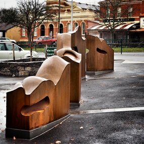
Artwork, other - Public Artwork, Cliff Burtt, Buninyong Bivium, 2016
Buninyong Bivium (2016) by Cliff Burtt engages with the geography and history of the Buninyong region in both pre and post settlement. The town of Buninyong is dominated by the profiles of Mt Helen and the extinct volcano Mt. Buninyong. Traditional land of the Wadawurrung people, today the area remains a significant site for the culture of indigenous people and their connection to the land. The profile of this sculpture is based on topographical mapping of the area, depicting sections of the landscape. The gaps between the elements of the work can be viewed as representations of the shafts sunk into the earth by the early gold miners and compound curves on the upper surfaces are mirroring the topography of the area, while cut-aways in the sides are suggestive of rock strata.The artwork is of aesthetic and social significance to the people of BallaratCorten steel sculpture made of five unique sculptural pieces secured to at concreate base at pavement levelbuninyong, cliff burtt, sculpture, public art, mining, ballarat -
Lakes Entrance Regional Historical Society (operating as Lakes Entrance History Centre & Museum)
Book, Haskell, Arnold L, Waltzing Matilda - A Background to Australia - The Diggers Edition, 1943
A view of Australia and Australians seen through the eyes of the author during his years of travel and association with Australians. Illustrated with photographs. IndexedRuth Clarksocial history, township, natural history, topography, law -
 Lakes Entrance Regional Historical Society (operating as Lakes Entrance History Centre & Museum)
Photograph, 1910c
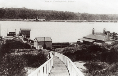
Also black and white copy 12.5 x 18 cm with smear of purple ink in top left hand corner, purchased from Helen ClothierTinted black and white photograph showing boardwalk from New Works Jetty over the sand dunes with small shed on jetty, small one room Boole Poole school on right of boardwalk and harbour master's house on right. Club Hotel on opposite foreshore and town on far right. Kalimna escarpment in background, at Lakes Entrance, Victoria.View of Cunninghame Victoriaboardwalk, waterways, ships and shipping, township, topography -
 Lakes Entrance Regional Historical Society (operating as Lakes Entrance History Centre & Museum)
Postcard, Bulmer H D, 1922c
Black and white photographic postcard, showing early aerial view of township of Lakes Entrance, Cunninghame Arm, North Arm and sand dunes, ocean in lower foreground, Eastern wharf and various boats on lake. Princes Highway went along Esplanade, Myer Street and Roadknight Street, very little vegetation on sand dunes, no foot bridge yet, good view of North Arm, few houses. Lakes Entrance VictoriaLakes Entrance and Backwater from the Air.islands, aerial photograph, waterways, topography, township -
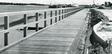 Lakes Entrance Regional Historical Society (operating as Lakes Entrance History Centre & Museum)
Photograph, Lakes Post Newspaper, 1991
Date made November 1991Black and white photograph of the waterfront walkway, showing a timber footpath and guard railings concrete edgings being constructed beside car park. Sandy beach and seaweed at edge of lake, fishing boats and tourist boat Thunder Bird moored at wharf in background. Lakes Entrance Victoriaguesthouses, religion, topography, township, waterfront -
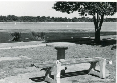 Lakes Entrance Regional Historical Society (operating as Lakes Entrance History Centre & Museum)
Photograph, Lakes Post Newspaper, 1992c
Black and white photograph of part of the lake and waterfront. It shows the scrub covered south shore, the Cunninghame Arm, the foreshore littered with dead seagrass, the path and lawn verge, and small concrete picnic table and broken seat. Lakes Entrance Victoriatearoom, township, waterways, topography, houseboat -
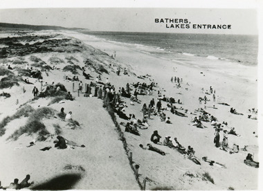 Lakes Entrance Regional Historical Society (operating as Lakes Entrance History Centre & Museum)
Postcard, 1950c
2 other copiesBlack and white small format postcard of bathers at the ocean beach. It shows a crowd of people on the sand dunes, remains of a brush fence, Southern Ocean and Red Bluff in distance. Taken from original tower, built for Royal Lifesaving Club. Lakes Entrance VictoriaBathers, Lakes Entrancebridges, associations, topography, people, room display -
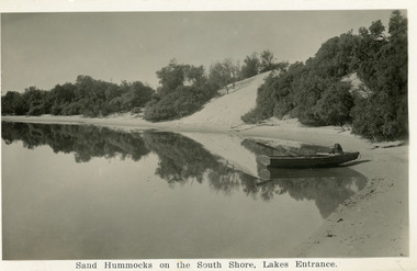 Lakes Entrance Regional Historical Society (operating as Lakes Entrance History Centre & Museum)
Postcard, Bulmer H D, 1930c
A second copy exists 16 x 25Black and white postcard of the south shore of Cunninghame Arm. It shows a rowing boat with dog, on the shore and the scrub covered sand hummocks. Lakes Entrance VictoriaSand Hummocks on South shore, Lakes Entrance.bridges, topography, waterways, people, associations -
 Lakes Entrance Regional Historical Society (operating as Lakes Entrance History Centre & Museum)
Photograph, 2008
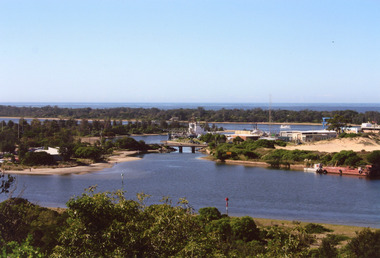
Date made August 2008Colour photograph of North Arm and Cunninghame Arm, taken from Jemmys Point, shows small bridge to Bullock Island, the Seamec educational facility in the background. Lakes Entrance Victoriabridges, fishing industry, islands, waterways, topography -
 Lakes Entrance Regional Historical Society (operating as Lakes Entrance History Centre & Museum)
Photograph, 1930c
Black and white photograph of Bullock Island, showing sparse vegetation on island, low foot bridge to island, reedy vegetation in foreground. Lakes Entrance Victoriatownship, topography, ocean, islands, bridges -
 Lakes Entrance Regional Historical Society (operating as Lakes Entrance History Centre & Museum)
Photograph, Fraser Ian, 1950c
Black and white photograph of Bullock Island, showing Prince's Highway from North Arm bridge, east end of Bullock Island and bridge, entrance to Bass Strait and sand dunes along Cunninghame Arm. Western end of Bullock Island bridge raised to allow small boats access to North Arm and Cunninghame Arm, became known as Humpy Bridge. Lakes Entrance Victoriafishing industry, islands, waterways, ships and shipping, topography -
 Lakes Entrance Regional Historical Society (operating as Lakes Entrance History Centre & Museum)
Photograph, Fraser, Nancy, 1970c
Black and white photograph of a distant view township and Cunninghame Arm and scrub covered hummocks of southern shore in distance. Lakes Entrance Victoriaislands, jetties, topography, waterways, roads and streets -
 Lakes Entrance Regional Historical Society (operating as Lakes Entrance History Centre & Museum)
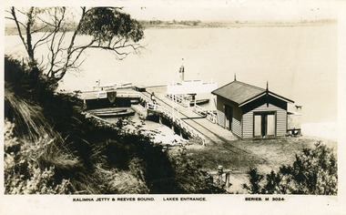
Postcard, Valentine Series, 1930c
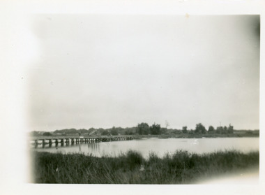
Also Black and white copy print 15 x 25Black and white postcard of Kalimna Jetty. It shows a substantial timber jetty with rail line and goods trolley, storage shed with square water tank. Passenger launch and four rowing boats moored at jetty. Navigation light towards end of jetty. Lakes Entrance VictoriaKalimna Jetty and Reeves Sound Lakes Entrance Series M 3024islands, jetties, waterways, topography, boats and boating -
 Lakes Entrance Regional Historical Society (operating as Lakes Entrance History Centre & Museum)
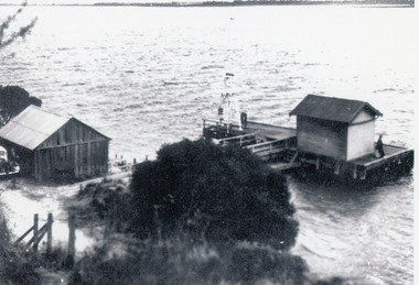
Photograph, 1938
Reprinted from Rev. Alfred Maher's photo album, Anglican Church Archives, Sale, VictoriaBlack and white photograph of Nyerimilang Jetty, Gippsland Lakes. It shows a short jetty with boat landing, navigation light and storage shed on jetty, boatshed on bank. Small motor car beside boat shed. Distant view across lake to eastern point of Flanagan Island, Fraser Island and Rigby Island. Lakes Entrance Victoriajetties, restaurant, boats and boating, waterways, topography -
 Lakes Entrance Regional Historical Society (operating as Lakes Entrance History Centre & Museum)
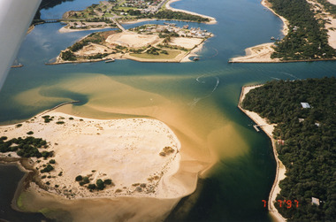
Photograph, 1997
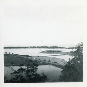
Date made 7 July 1997Colour photograph being an aerial view of the western end of Cunninghame Arm, showing the entrance between the hummocks, Bullock Island, entrance to North Arm, Snake Island surrounded by sand build-up. Lakes Entrance Victoriatopography, waterways, aerial photograph, boats and boating, township -
 Lakes Entrance Regional Historical Society (operating as Lakes Entrance History Centre & Museum)
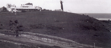
Photograph, 1925c
Black and white photograph of Merrangbaur Hill, showing Merrangbaur House, and an old vine covered tree, which was a landmark for vessels at sea off the coast. Fenced off roadway at base of hill with water course alongside. Distant glimpse of surf and ocean. Lakes Entrance Victoriaguesthouses, roads and streets, topography, coast, fences -
 Surrey Hills Historical Society Collection
Book, An historical geography of Surrey Hills, 1882-1913, 1979
A thesis submitted for the Degree of Bachelor of Arts with Honours. This thesis presents in a description form, the development of Surrey Hills, an eastern suburb of Melbourne. The settlement and growth from a rural district in 1882 to a suburban centre in 1913.This thesis presents in a description form, the development of Surrey Hills, an eastern suburb of Melbourne. The settlement and growth from a rural district in 1882 to a suburban centre in 1913.surrey hills, geography, topography, j. knipe, land use, population -
 Surrey Hills Historical Society Collection
Book, An historical geography of Surrey Hills, 1882-1913, 1979
A thesis submitted for the Degree of Bachelor of Arts with Honours. This thesis presents in a description form, the development of Surrey Hills, an eastern suburb of Melbourne. The settlement and growth from a rural district in 1882 to a suburban centre in 1913.This thesis presents in a description form, the development of Surrey Hills. The settlement and growth from a rural district in 1882 to a suburban centre in 1913.surrey hills, geography, topography, j. knipe, land use, population -
 Forests Commission Retired Personnel Association (FCRPA)
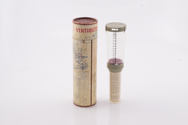
Ventimeter, Wind anemometer in cardboard tube
Bushfire behaviour is influenced by many factors including temperature, relative humidity (RH), forest type, fuel quantity and fuel dryness, topography and even slope. But wind has a dominant effect on the Rate of Spread (ROS), as well as fire size, shape and direction. Wind speed can be measured using a variety of anemometers. This simple hand-held Venitimer was made by Elvometer in Sweeden, probably in the 1960s, and was designed for principally for mariners. Some models have a compass in the handle to measure wind direction. The small inlet hole on the side is faced towards the wind and air pressure lifts small plastic disk inside. The upper tube is tapered so that as wind speed increases more air escapes and stronger winds are needed to raise the disk. Wind speed in MPH is read from the side of the clear plastic tube. The waterproof container has instructions on use and conversion scales. Simple and robust device.Hand- held wind anemometer Instructions on use on containerbushfire -
 Forests Commission Retired Personnel Association (FCRPA)
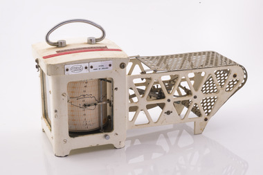
Thermo Hygro Graph
Bushfire behaviour is influenced by many factors including temperature, relative humidity (RH), forest type, fuel quantity and fuel dryness, topography and even slope. Wind has a dominant effect on the Rate of Spread (ROS), as well as fire size, shape and direction. Temperature and relative humidity have major impacts on fuel dryness and therefore upon the availability of fuel for combustion. A thermo-hygrograph measures and records both temperature and humidity. It produces a continuous record by drawing ink traces on a paper chart held in revolving cylinder. Humidity is measured by shortening or lengthening of specially treated human hair. Temperature is measured by means of a bi-metallic strip. This particular instrument is a seven day recorder. The instrument is driven by clockwork. Serial number 10186 which probably dates from about 1960. The chart indicates it was last used in March 1979.Used for bushfire research.Clockwork Thermo Hygro GraphCasella London 10186 Made in England Research Branch. Forests Commission Orbostbushfire -
 Surrey Hills Historical Society Collection
Photograph, Boys who later joined the 1st Surrey Hills scout troop, 1909
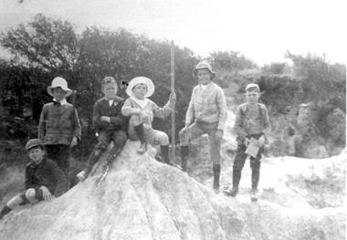
1st Surrey Hills was the 3rd troop formed in Victoria. Harrison Buchanan was not old enough to join and for a time was the 'troop mascot' as the cubs had not been formed at this time. He later became the troop's 2nd Scoutmaster. Doug Jeffries lived at 12 Vincent Street. Alex Lucas was the son of the draper in Canterbury Road. Our documentation variously gives the date as 1901 or 1909.Six boys are pictured against a backdrop of scrub in the eroded creek bed, called 'The Alps', of Back Creek opposite Wattle Park. Three of them are identified as: Harrison Buchanan (with the stave), Doug Jeffries on the LHS and Alex Lucas next to him.Black and white photo measuring L 24.5 cm x H 17.4 cmback creek, 1st surrey hills scout troop, scouts, harrison buchanan, alex lucas, doug jeffries, childhood and youth, topography -
 Federation University Historical Collection
Book, Memoirs of the Geological Survey of Victoria No 14 The Ballarat Goldfields, 1923, 1923
William Baragwanath was educated at the Ballarat School of Mines, obtaining a Geology Certificate in 1911. After further study he went on the become Secretary for Mines, and Chief Mining Surveyor. Baragwanath was a Councillor of the Ballarat School of Mine from 1916 to 1950.Pink covered foolscap book of 257 pages and 32 maps and plans by William Baragwanath. Contents include topography, physiography, historical, geology, basalt, faults, dykes, minerals leads, alluvial mines, nuggets, structure of Ballarat West goldfields, structure of Ballarat East gold-field, quartz formation, indicators, defunct mines, existing mines, table of deepest shafts. Images include: section of the Ballarat Gold-Field, Dead HOrse Flat, lakes formed by Basalt Flows, Gong Gong Creek, Frenchman's Lead, Ballarat West Mines, LEases and positions of shafts (1857), puddling, White Horse Lead, Woah Hawp Canton, Ballarat Township mines, Sebastopol, syncline, Victoria United Line, First Chance Mine, Llanberris No 1 Mine, Saddle Reef, New Normanby Mine, Woah Hawp Canton Mine, South Star Mine, Sebastopol Plateau, south Woah Hawp Mine, Woah No. 2 Minegeology, geological survey no 14, ballarat, baragwanath, william baragwanath