Showing 463 items
matching track work.
-
 Ballarat Heritage Services
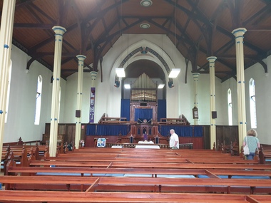
Photograph - Church, Clare Gervasoni, Daylesford Uniting Church Interior, 2023, 04/03/2023
The Daylesford Uniting Church (formerly Wesleyan /Methodist Church) was built in 1865, replacing an earlier Wesleyan Chapel built in 1861 which is still on site and known as the Sunday School (2024). The foundaton stone for the newer, current church was laid on 12 June 1865, designed by Architects Crouch and Wilson the structure was built in early English Gothic style. The first service was held in the new church on 10 December 1865. It is of interest for its brick broach spire, diapered brick façade and spacious interior with aisles separated from the nave by slender columns. The church organ was installed and built in 1888 by William Anderson and boasts an impressive 724 pipes, many of which are decorated with Christian symbols. This organ is a rare example of Anderson’s work and is his only instrument in Western Victoria. It is classified by the National Trust of Australia (Victoria) as being of state significance. The organ was renpvated in 1979-80 by Leighton Turner. It has 2 manuals, 14 speaking stops, 3 couplers, tracker action, Gt: 8.8 divided.8.4.4.2-2/3.2. Sw: 8.8.4.2.8. Ped: 16. In the 1880s the decline in mining led to the congregation considering ways to reduce debt. Rent was received from pew hire as well as organ concerts and annual fairs. By the end of the 19th century the church had settled into a pattern of steady parish life. The 1950s and 1960s were really the glory days of the church with an active Sunday School, tennis clubs and vibrant social activity as well as many worshippers at Sunday services. The final service was held at the church on 21 April 2024.A redbrick church on stone foundation in Daylesforddaylesford uniting church, daylesford methodist church, daylesford, john mitchell uniting church, daylesford wesleyan church, crouch and wilson, daylesford uniting sunday school -
 Ballarat Heritage Services
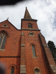
Photograph - Church, Clare Gervasoni, Daylesford Uniting Church, 2023, 04/03/2023
The Daylesford Uniting Church (formerly Wesleyan /Methodist Church) was built in 1865, replacing an earlier Wesleyan Chapel built in 1861 which is still on site and known as the Sunday School (2024). The foundaton stone for the newer, current church was laid on 12 June 1865, designed by Architects Crouch and Wilson the structure was built in early English Gothic style. The first service was held in the new church on 10 December 1865. It is of interest for its brick broach spire, diapered brick façade and spacious interior with aisles separated from the nave by slender columns. The church organ was installed and built in 1888 by William Anderson and boasts an impressive 724 pipes, many of which are decorated with Christian symbols. This organ is a rare example of Anderson’s work and is his only instrument in Western Victoria. It is classified by the National Trust of Australia (Victoria) as being of state significance. The organ was renpvated in 1979-80 by Leighton Turner. It has 2 manuals, 14 speaking stops, 3 couplers, tracker action, Gt: 8.8 divided.8.4.4.2-2/3.2. Sw: 8.8.4.2.8. Ped: 16. In the 1880s the decline in mining led to the congregation considering ways to reduce debt. Rent was received from pew hire as well as organ concerts and annual fairs. By the end of the 19th century the church had settled into a pattern of steady parish life. The 1950s and 1960s were really the glory days of the church with an active Sunday School, tennis clubs and vibrant social activity as well as many worshippers at Sunday services. The final service was held at the church on 21 April 2024.A redbrick church on stone foundation in Daylesforddaylesford uniting church, daylesford methodist church, daylesford, john mitchell uniting church, daylesford wesleyan church, crouch and wilson, daylesford uniting sunday school -
 Ballarat Heritage Services
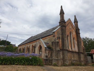
Photograph - Church, Clare Gervasoni, Former Daylesford Wesleyan Chapel, 2023, 04/03/2023
The Daylesford Uniting Church (formerly Wesleyan /Methodist Church) was built in 1865, replacing an earlier Wesleyan Chapel built in 1861 which is still on site and known as the Sunday School (2024). The foundaton stone for the newer, current church was laid on 12 June 1865, designed by Architects Crouch and Wilson the structure was built in early English Gothic style. The first service was held in the new church on 10 December 1865. It is of interest for its brick broach spire, diapered brick façade and spacious interior with aisles separated from the nave by slender columns. The church organ was installed and built in 1888 by William Anderson and boasts an impressive 724 pipes, many of which are decorated with Christian symbols. This organ is a rare example of Anderson’s work and is his only instrument in Western Victoria. It is classified by the National Trust of Australia (Victoria) as being of state significance. The organ was renpvated in 1979-80 by Leighton Turner. It has 2 manuals, 14 speaking stops, 3 couplers, tracker action, Gt: 8.8 divided.8.4.4.2-2/3.2. Sw: 8.8.4.2.8. Ped: 16. In the 1880s the decline in mining led to the congregation considering ways to reduce debt. Rent was received from pew hire as well as organ concerts and annual fairs. By the end of the 19th century the church had settled into a pattern of steady parish life. The 1950s and 1960s were really the glory days of the church with an active Sunday School, tennis clubs and vibrant social activity as well as many worshippers at Sunday services. The final service was held at the church on 21 April 2024.A stone church in Daylesford. Originally built at the Daylesford Wesleyan Chapel, it was later used as the Daylesford Uniting Church Sunday School. daylesford uniting church, daylesford methodist church, daylesford, john mitchell uniting church, daylesford wesleyan church, daylesford uniting sunday school -
 Ballarat Heritage Services
Photograph - Church, Clare Gervasoni, Daylesford Uniting Church John Mitchell Memorial Hall, 2023, 04/03/2023
The Daylesford Uniting Church (formerly Wesleyan /Methodist Church) was built in 1865, replacing an earlier Wesleyan Chapel built in 1861 which is still on site and known as the Sunday School (2024). The foundaton stone for the newer, current church was laid on 12 June 1865, designed by Architects Crouch and Wilson the structure was built in early English Gothic style. The first service was held in the new church on 10 December 1865. It is of interest for its brick broach spire, diapered brick façade and spacious interior with aisles separated from the nave by slender columns. The church organ was installed and built in 1888 by William Anderson and boasts an impressive 724 pipes, many of which are decorated with Christian symbols. This organ is a rare example of Anderson’s work and is his only instrument in Western Victoria. It is classified by the National Trust of Australia (Victoria) as being of state significance. The organ was renpvated in 1979-80 by Leighton Turner. It has 2 manuals, 14 speaking stops, 3 couplers, tracker action, Gt: 8.8 divided.8.4.4.2-2/3.2. Sw: 8.8.4.2.8. Ped: 16. In the 1880s the decline in mining led to the congregation considering ways to reduce debt. Rent was received from pew hire as well as organ concerts and annual fairs. By the end of the 19th century the church had settled into a pattern of steady parish life. The 1950s and 1960s were really the glory days of the church with an active Sunday School, tennis clubs and vibrant social activity as well as many worshippers at Sunday services. The final service was held at the church on 21 April 2024.A small hall in the grounds of Daylesford Uniting Church. John Mitchell was a teacher and superintendent from September 1861 to 1921. The hall was still in existence in August 2024.John Mitchell Memorial Hall 1931daylesford uniting church, daylesford methodist church, daylesford, john mitchell uniting church, daylesford wesleyan church, daylesford uniting sunday school, john mitchell -
 Port Melbourne Historical & Preservation Society
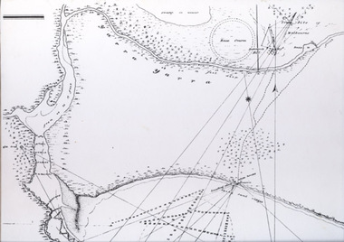
Map - Track, Sandridge to Melbourne, 1840
Bromide of surveyor's sketch of the track to Melbourne from Sandridge (Liardet's Beach), 1840. Originals with Lands Department, Melbourne. (possibly the work of William Wedge DARKE?)Slight processing stain upper right, '6' on backbusiness and traders - hotels, william wedge darke, piers and wharves -
 Port Melbourne Historical & Preservation Society
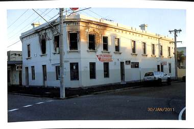
Photograph - Various Port Melbourne locations, Jack Bolt, 2011
Photographed Jan/Feb 2011 by Jack BOLTFrom a series of colour photos taken by Jack Bolt in January/February 2011 .01 - Hibernian Hotel 30.01.2011 after the second fire on 28 November 2010 .02 to .09 - Eight photos of route109 tram tracks being replaced between 29.01.2011 to 2.02.2011 (Graham St stop) .10 - view from upper floor of Woodruff Terrace .11 - air shaft Farrer & Ross Sts. Latter two photos are of work on the Melbourne Main Sewer, Ross and Bridge Streetstransport - tramways, engineering - canals and drainage, fire and fire services, hibernian hotel, jack bolt, business and traders - hotels -
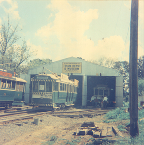
 Ballarat Tramway Museum
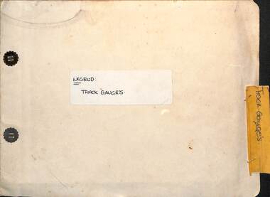
Administrative record - Report, State Electricity Commission of Victoria (SECV), "Legend - Track gauges", 1954/55
Record shows the condition of the rail head at many points throughout the Ballarat system. Gives the type of rail, its weight, gauge, location and date of measurement See item 9127 for a report on the Special Work. Some sections measured in May 1954, rest May 1955Demonstrates a detailed report into the condition and wear of the Ballarat Tramways trackwork in 1954/1955.Report - within a manila card folder with steel clips containing about 44 drawings on drawing paper of rail sections.Outside cover in ink "Legend Track Gauges"ballarat, secv, trackwork, rails, reports -
 Sunbury Family History and Heritage Society Inc.
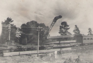
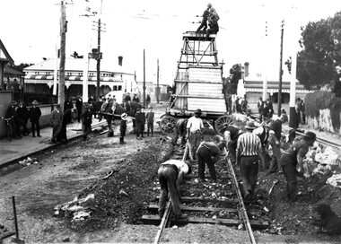
Photograph, Bridge repairs
Work was being done repairing a bridge on the Sunbury - Bendigo line at the former Rupertswood siding, which in the past was used initially by guests who would arrive at the Rupertswood mansion and of later years by students from Salesian College. The siding has been dismantled. Students now use buses to travel to and from the school.A scanned non-digital black and white photograph of work being done along a rail line. There is a large crane beside the rail track and a rail car is also on the line.railways, salesian college, rupertswood siding., rupertswood estate. -
 Melbourne Tram Museum
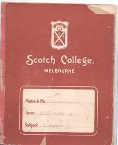
Book - Cable tram records - book 2 of 4, Alf Twentyman, c1940
Second of four documents compiled by Alf Twentyman about the history of Melbourne cable trams. The first seven pages list each cable car or trailer (1 to 601) and its depot, including some notes on their individual disposal. Page 15 lists additions to the fleet of cars - 1-7-1916 to 3-6-2024 including numbers and notes. Pages 16 to 37 provide cable and track diagrams and notes on St Kilda Junction, Collins and Market St, City Road & Clarendon St, Elizabeth St, Spring-Albert and Brunswick Sts, Swanston St, (Princes Bridge to Lonsdale St) and Lonsdale St to Russell St, Spencer St and Flinders St including the Bourke St terminus, Clifton Hill terminus, Nicholson and Gertrude, Spring and Nicholson, Lygon Elgin and Rathdowne Sts, various terminal arrangements and car shed access, Queensberry and Abbotsford, St Kilda Road, Chapel and Wellington, Ackland St and other notes on the last pages.Demonstrates the recording and drawing work of Alf Twentyman and his notes.Exercise book - printed for Scotch College, ruled in an accounting ledger format - 40 pages with red card covers.On cover in ink "A E Twentyman, Inter Maths B Ledger"tramways, cable trams, alf twentyman, history, track plans, records -
 Melbourne Tram Museum
Book - Cable tram records - book 1 of 4, Alf Twentyman, c1940 to 1985
First of four documents compiled by Alf Twentyman about the history of Melbourne cable trams. On the inside of the rear cover has a table of contents - see image 1. Includes sketches of San Francisco grips, sketches of destination signs on the cable cars, Auburn Road and Kew horse tram timetables rolling stock, sketch of St Kilda Road, Victoria Parade - Brunswick St, listing of ropes and their life spans, tables of cars out for various depots, timetables, list of visitors to Northcote, new MMTB rolling stock listing.Demonstrates the recording and drawing work of Alf Twentyman and his notes.Exercise book - part ruled - part plain pages - 92 numbered pages + fawn coloured covers, centre stapled.tramways, cable trams, alf twentyman, history, track plans, records -
 Ballarat Tramway Museum
Photograph - BTPS Depot - 1 road under construction, c Oct. 1973
Colour print of trams 40 and 26 on the depot fan, with No. 1 road under construction. Date not known, based on the work - Sept/Oct. 1973. Work on No. 1 road was completed by Dec. 1973. Tram 26 is being used as the display tram.Yields information about the construction of the track in the depot fan. Colour print - on Agfa paper.tramcars, trams, btps, tram 40, tram 26, trackwork -
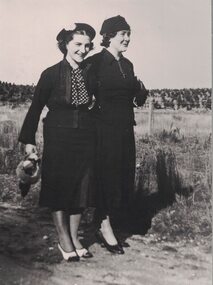 Linton and District Historical Society Inc
Photograph, Kitty Jennings and Joyce Chung
Kitty (Catherine) Sandow and Joyce Rowe grew up in Linton and attended Linton State School. Kitty Sandow (1916-1984) married Reg Jennings in 1946. Joyce Rowe (1912-1997) married Mick (Martin) Chung in 1931. Kitty and Reg took over the management of Kitty's parent's grocery and confectionery shop, which then became known as "Jennings' Milk Bar". Joyce, a descendant of the Nicol family, worked at Nicol's bakery. Her husband Mick Chung worked for the railways.Enlarged black and white copy of original photograph which has been mounted on card. The photograph shows two women, both wearing dark coloured jackets and skirts, hats and dress-shoes. The woman on the left is carrying a handbag, while the woman on the right has a handbag tucked under her arm. They are standing on a roadway or track, and a wire fence and paddock can be seen in the background. Kitty Jennings (née Sandow) and her friend Joyce Chung (née Rowe). The photograph is undated.joyce chung (née rowe), kitty jennings (née sandow) -
 Falls Creek Historical Society
Photograph - Axtrack oversnow vehicle Falls Creek Hotel
This vehicle, an Axtrack is located outside the Falls Creek Museum. It was built by Axel Andre who worked in Falls Creek as a mechanic for several years in the early 1970s. Axel was an engineer by trade. He built this small twin track vehicle for Ivan Spargo at the Falls Creek Hotel and then progressed to building bigger and better models. This included one for Ziggy Doer at Koki and Neville Mashford at Snowland purchased two of them. Some of these machines were also exported to America. Axel Andre later established a company Axtrack Engineering in Melbourne. There are still three of these Axtrack vehicles on the hill at Falls Creek in 2024. The vehicles were used for commercial purposes such as transporting supplies and staff around the mountain. The Spargo family from the Falls Creek Hotel used this vehicle for oversnow transport and it advertised Harvey Wallbanger Happy Hour. Ivan and Joy Spargo relocated from Melbourne to Falls Creek in 1965. They purchased a piece of leasehold land and built Spargo Lodge. This was a dorm style chalet built to accommodate large groups and families. Their son Rob Spargo met his future wife Blanche in 1967 when she was on holiday in Falls Creek. They married and purchased the site where the Falls Creek Hotel is today. The steep gradient of the site was a challenge to build on but was the best location available in the village. In 1970 Rob’s sister Leonie and her husband Glenn joined the business, and they started operating the hotel in 1972. The family played a critical role in the growth of the Falls Creek community and were involved in the foundation of Falls Creek Primary School and Falls Creek Search & Rescue. Rob was also involved in the start-up of Ski Victoria and has served as a member of the Chamber and Resort Management Board. Rob’s eldest daughter Lisa competed with the Australian Ski Team from 1985 to 1989 and has worked as a ski instructor in Australia, Austria & Colorado. In 2010 Lisa and her husband Damien Allport joined the family business and her parents retired to Tawonga South in 2014. Their children are now the fourth generation of the Spargo family living at Falls Creek enjoying the alpine lifestyle and providing outstanding hospitality. The 40 year tradition of the Harvey Wallbanger Happy Hour held on Tuesdays and Thursdays continues at Falls Creek Hotel in 2024.This item is significant because it depicts an important form of transport at Falls Creek, VictoriaA coloured photo of a black Axtrack oversnow vehicle decorated with red and yellow advertising.FALLS CREEK HOTEL APRES ENTERTAINMENT HARVEY HOUR TUES & THURS 3.30 PM LIVE ENTERTAINMENTaxtrack, oversnow vehicles, falls creek transport, spargo lodge, falls creek hotel -
 Eltham District Historical Society Inc
Photograph - Digital Photograph, Marguerite Marshall, One Tree Hill Mine, Smiths Gully, 8 June 2006
Gold was discovered on One Tree Hill in 1854. The site has been worked intermittently until fairly recent times. Published: Nillumbik Now and Then / Marguerite Marshall 2008; photographs Alan King with Marguerite Marshall.; p53 Though still a working mine, One Tree Hill Mine at Smiths Gully, now stands in a tranquil reserve surrounded by bush and native animals - in contrast to its heyday. In the mid 19th century, when the mine was part of the Caledonia Goldfields, hundreds of men in search of their fortune worked the alluvial gold in the Yarra River, its tributaries and the reefs that made up the goldfields. Miner Stan Bone, assisted by Wilfred Haywood, is the last of the independent gold miners in the area and still uses the quartz crushing battery as miners did when gold was first discovered in the area in 1851.1 Stan, who is the last of six generations of miners in his family, was aged 17 when he began mining on his father Alex’ mine, The Golden Crown in Yarrambat. These days, after blasting the gold-bearing rock in Mystery Reef, one of the four reefs at One Tree Hill, Stan transports it around five kilometres by tip truck to the Black Cameron Mine for crushing. There he uses water from the waterlogged mine, (which still contains gold), as the Happy Valley Creek at One Tree Hill is usually dry.2 The One Tree Hill Mine has been worked for close to a century since it opened around the late 1850s.3 The Swedish Reef was its most productive reef and one of the largest in the area. Around 1859, extractions included 204 ounces (5.8kg) of gold, won from 57 pounds (26kg) of stone.4 Then during World War Two, Stan’s uncle, Bill Wallace, and Alex Bone, closed the mine. In 1973, Stan, with his Uncle Bill, reopened the Black Cameron Mine and worked there until 1988. Stan resumed mining One Tree Hill in 1998. As late as the 1920s gold was picked up by chance! When crossing a gully on his way to vote at the St Andrews Primary School, Bill Joyce picked up some quartz containing gold. This site was to become the Black Cameron Mine. The Caledonia Diggings, named after Scotland’s ancient name by local Scots, began around Market Square (now Smiths Gully) and included Queenstown (St Andrews), Kingstown (Panton Hill) and Diamond Creek. There were also poorer bearing fields in Kangaroo Ground and Swipers Gully (now Research). * None of these compared in riches to the Ballarat and Bendigo fields5, but the Caledonia Diggings continued intermittently for close to 100 years. Gold was discovered in Victoria following a bid to stem the disappearance of much needed workmen to the New South Wales diggings. Several businessmen offered a reward of £200, for the discovery of gold within 200 miles (322 km) of Melbourne. Late in June 1851, gold was first discovered at Andersons Creek, Warrandyte. Then in 1854, George Boston and two other men discovered gold at Smiths Gully. Gold transformed the quiet districts, with a constant flow of families and vehicles on the dirt tracks en route to the Caledonia Diggings. Three thousand people worked the gullies in Market Square, including about 1000 Chinese miners. The square established its own police, mining warden, gold battery, school, shops and cemetery and grog flowed. Market Square flourished until the middle 1860s. Bullocks transported quartz from the Caledonia Goldfields to the crushing machinery at the Queenstown/St Andrews Battery, near Smiths Gully Cemetery. It was destroyed by bushfire in 1962. By the late 1850s, most early alluvial fields were in decline, but minor rushes continued until around 1900 and some until the early 1940s. Some miners did well, although most earned little from their hard labour in the harsh and primitive conditions.6 But according to historian, Mick Woiwod, the gold fields helped to democratise society, as individuals from all walks of life were forced to share experiences, and the ability to succeed, depended less on inherited wealth or social rank.This collection of almost 130 photos about places and people within the Shire of Nillumbik, an urban and rural municipality in Melbourne's north, contributes to an understanding of the history of the Shire. Published in 2008 immediately prior to the Black Saturday bushfires of February 7, 2009, it documents sites that were impacted, and in some cases destroyed by the fires. It includes photographs taken especially for the publication, creating a unique time capsule representing the Shire in the early 21st century. It remains the most recent comprehenesive publication devoted to the Shire's history connecting local residents to the past. nillumbik now and then (marshall-king) collection, gold mining, one tree hill mine, smiths gully -
Bialik College
Audio (Item) - 1999 Bialik College Bnei Mitzvah Band and Vocals, Master Cd, 1999
... School Music Bialik Secondary School Student work Track List: 1 ...Created for the 1999 Bnei Mitzvah Please contact [email protected] to request access to this record. Track List: 1. Lori Alleh 2. Yeah Li Yom Yom Chag 3. Ani Rak Ben Adam 4.Eli 5. Hero 6. Rikdi 7. Artzeinu 8. Hora Mamtera 9. Noladeti Lashalom 10.Aba-Ni-Bi 11. Chiri-Bim 12.Hine Yamim Ba'Im bnei mitzvah, jewish school, music, bialik, secondary school, student work -
Bialik College
Audio (Item) - Yoddi cd, 1998
... Jewish School Student work Track list: 1. OSF 2. No Right 3 ...Recorded in 1998 Please contact [email protected] to request access to this record. Track list: 1. OSF 2. No Right 3. Final Goodbye 4. 40 Minutes 5. On Edge 6. Elevator 7. Higher 8. Salvation. Contributors: Joel Finkelstein, Paul Glezer, Julian Feldman, Arik Blum. All songs by Yoddi. Please contact [email protected] to request access to this record.music, bialik, secondary school, jewish school, student work -
Bialik College
Audio (Item) - Bialik College 'Bialik Ensembles'
... to this record. Music Bialik Secondary School Jewish School Student work ...No date. Recording created as part of a student assessment. Please contact [email protected] to request access to this record. Track list 1. Guajilo 2.Old Fashioned 3.Az Der Rebbe 4. Tumbelika 5. Ostinato 6. For Whom the Bell Tolls 7. Live Wire 8. Hello Goodbye 9. Oblida Oblada 10. Born to Shine 11. Katum 12. Gabrielle 13. When the Sun Goes Down 14. Foolish games 15. Cherish 16. Fade to Black 17. Hard to Say I'm Sorry 18. I'm Not Talking. Please contact [email protected] to request access to this record.music, bialik, secondary school, jewish school, student work -
Bialik College
Audio (Item) - Student & staff audio work, visual presentations and performing arts
Audio and visual tracks created in relation to course work and presentations for Bialik College students Please contact [email protected] to request access to this record. music, performing arts, presentation, staff, students, jewish life -
 Eltham District Historical Society Inc
Photograph - Digital Photograph, Alan King, Kinglake National Park, 27 March 2008
Fern gullies around Jehosaphat Gully Covered under National Estate. Published: Nillumbik Now and Then / Marguerite Marshall 2008; photographs Alan King with Marguerite Marshall.; p125 The magnificent Kinglake National Park, fringing Nillumbik’s north, is the largest national park close to Melbourne. Thanks to the vision and hard work of a band of local people, the park was created from what was rapidly becoming degraded land. Seeing a threat to Kinglake’s indigenous flora and fauna, several prominent local people campaigned for a national park, which was established in 1928.1 Since then, the park has grown through donations and acquisitions of land, from around 13,800 acres of land (5585ha) to 22,360 hectares. The Sugarloaf and Everard Blocks – of almost 8000 hectares – stand in Nillumbik and the park extends into Mitchell and Murrundindi Shires and the City of Whittlesea. Mt Everard commemorates William Hugh Everard, State member for Evelyn when the park was established. Before 1928, European settlers had degraded the Kinglake area, which was named after the celebrated English author and lawyer, Alexander William Kinglake. Remains of gold shafts and diggings in the park are reminders of Kinglake’s first settlers, who hoped to strike it rich at the gold diggings. But like other gold fields in this shire, they proved not very lucrative and soon timber cutting replaced mining in importance. However, before long, the accessible timber supply ran out, so in the 1920s agriculture took over – particularly potatoes and berry fruits – which involved large-scale clearing.2 The park’s instigator was retired Melbourne University Professor of Music, William Laver.3 As chair of the Kinglake Progress Association he began negotiations to have crown lands on the southern scarp of the Great Dividing Range reserved as a national park. Even before the park was proclaimed, from 1927, KPA members cut tracks to the major scenic points. Professor Laver was one of several people who gave land for the park, donating around 50 acres (20ha), including the Jehosaphat Gully.4 Laver chaired the park’s first Committee of Management, which raised money to employ a ranger and provide facilities, including tracks and roads for fire protection vehicles, toilets and shelters. The committee charged fees for firewood collection, some grazing of livestock, and visitor entrance, and obtained small State Government and Eltham Shire grants. In 1957 the State Government provided revenue for national parks. Then, in 1975, the State Government took over the management and the Committee of Management became an advisory committee, which disbanded in 1978. Originally, the park covered crown land in the Shires of Eltham and Whittlesea; then Wombelano Falls in Yea and other areas were added. In 1970 the park extended into the Shires of Eltham, Healesville, Whittlesea and Yea.5 Bush fires have been an ongoing problem. In 1939 hundreds of eucalypts and acacias had to be sown around the Jehosaphat Gully to rejuvenate the forest. To manage bushfires, the Committee of Management, then the State Government, worked closely with the Forestry Commission, shire councils and local fire brigades. Early national parks focussed on recreation. But by the 1980s, conservation, education and scientific research became more important, playing a vital role in preserving representative samples of the natural environment. Each year many thousands of people use the park’s extensive network of walking tracks amongst the protected plant and animal life as well as camping, cycling and horse riding. The park, along the slopes of the Great Dividing Range, has lookouts revealing magnificent views of the Melbourne skyline, Port Phillip Bay, the Yarra Valley and the You Yangs. Vegetation in the Masons Falls area includes messmate forest, Austral grass-trees, ferns and Hazel Pomaderris. In spring, orchids, lilies, everlasting daisies, correas, grevillea and heath appear. Around Jehosaphat Gully are wet and dry forest, fern gullies and banksia. Animal life includes wallabies, kangaroos, koalas, echidnas, possums, gliders and bandicoots. Male lyrebirds can be heard mimicking in the Jehosaphat Gully, particularly in the Everard Block in winter.This collection of almost 130 photos about places and people within the Shire of Nillumbik, an urban and rural municipality in Melbourne's north, contributes to an understanding of the history of the Shire. Published in 2008 immediately prior to the Black Saturday bushfires of February 7, 2009, it documents sites that were impacted, and in some cases destroyed by the fires. It includes photographs taken especially for the publication, creating a unique time capsule representing the Shire in the early 21st century. It remains the most recent comprehenesive publication devoted to the Shire's history connecting local residents to the past. nillumbik now and then (marshall-king) collection, kinglake national park, jehosaphat gully -
 Eltham District Historical Society Inc
Photograph - Digital Photograph, Alan King, Rob Roy Hill Climb, 24 November 2007
The Rob Roy Hill Climb originated in 1935 on the property of former Heidelberg Mayor, William Clinton, where he reared the Rob Roy breed of miniature ponies. He established Pleasure Grounds on part of the property attracting groups of Sunday visitors from Melbourne's inner suburbs. Visitors enjoyed a picnic area, pony rides, a dance hall and a tap room. Young men would ride their BSA or Harley Davidson motorcycles to the property which led to regular club-organised hillclimb meetings between 1930 and 1936. In 1935 Clinton offered the use of his property to the Light Car Club of Australia for their hillclimbs. The track was sealed that same year and the hillclimb at Clintons Road was one of only three specially designed bitumen surface hillclimbs in the world, the others being Shelsey Walsh and Prescott Hillclimbs in the UK. The first Light Car Club of Australia hillclimb was held at Rob Roy in February 1937. Covered under Heritage Overlay, Nillumbik Planning Scheme. Published: Nillumbik Now and Then / Marguerite Marshall 2008; photographs Alan King with Marguerite Marshall.; p133 About six times a year the unlikely sound of car engines emerges from deep in the heart of Christmas Hills.* Usually a quiet retreat, the Hills are home to one of the world’s oldest purpose-built motor sport venues - the Rob Roy Hillclimb. When sealed in 1939, the hillclimb at Clintons Road was one of only three specially designed bitumen surface hillclimbs in the world, the others being Shelsley Walsh and Prescott Hillclimbs in the UK.1 The Rob Roy Hillclimb originated in 1935 on the property of former Heidelberg mayor, William Clinton, where he reared the Rob Roy breed of miniature ponies. Rob Roy was the Scottish folk hero and outlaw. On part of his property Clinton established Pleasure Grounds, attracting Sunday parties from Melbourne’s inner suburbs. Visitors enjoyed a picnic area, pony rides, a dance hall and a tap room.2 Young men riding on their BSA or Harley Davidson bikes led to club-organised regular hillclimb meetings, between 1930 and 1936. In 1935 Clinton offered his property to the Light Car Club of Australia for their hillclimbs. In February 1937, the first Light Car Club of Australia hillclimb meeting was held at Rob Roy. Jack Day achieved the fastest time that day for the 760 yard (695m) track at 36 seconds in a Ford V8 engined Bugatti Special. At first the climb was just a dusty gravel track, but in 1939 it was up-graded and bituminised. Today the 695 metre track begins on a slight incline, proceeds through a sharp right turn, which formerly passed a rusty iron shed, now remembered by the name Tin Shed Corner. The track continues down a slight incline to a level stretch along the top of an embankment holding back a half-acre (0.2ha) dam, then up to a one-in-three gradient. The track then winds uphill through several left turns to the finish line. In 1939 Frank Kleinig reduced the record to 29.72 seconds in an MG Hudson. Throughout World War Two the Rob Roy Hillclimbs were suspended, but were resumed in 1947. The hillclimbs consistently attracted crowds averaging 500 to 600 people, peaking at 2000, until the hillclimb was destroyed by the 1962 bushfires. The meetings included nine Australian Hillclimb Championships, with the first in 1938 won by Peter Whitehead in his ERA. Eight of the Outright and Class record holders were Australian Grand Prix winners including Jack Brabham, who became a triple F1 World Champion. The Light Car Club of Australia held 61 meetings at Rob Roy. Events usually included Touring, Gran Turismo, Production, Sports, Racing and Vintage cars and in the latter years Go-carts. These meets suddenly stopped after the 1962 bushfire destroyed the access bridge on the property leading to the track area, although fortunately Clinton saved his home. The club then established the Lakeland Hillclimb venue close to Lilydale.3 From 1979 to 1987 the MG Car Club ran hill climbs at the Templestowe Hillclimb until the land was to be sub-divided. In 1991 the MGCC approached the Shire of Nillumbik about using the derelict Rob Roy venue. In 1992, after much lobbying, the club signed a ten-year lease from Melbourne Water, which has been renewed. The original track was faithfully reconstructed. Access roads were improved and guard rails were installed on the causeway. Permanent structures were rebuilt and tonnes of rubbish removed. This was made possible by an immense amount of voluntary work by MGCC members and financial support from the newly formed Friends of Rob Roy. In February 1993 the first Return to Rob Roy Historic Meeting was run with a huge spectator attendance of around 1000 enthusiasts. In September 2007, the Nillumbik Shire Council gave the hillclimb heritage protection. This acknowledged the property’s significant contribution to early Australian motor sport with its social connection to William Clinton and the local community.4 *Christmas Hills was named after emancipated convict and shepherd David Christmas, lost in these hills.This collection of almost 130 photos about places and people within the Shire of Nillumbik, an urban and rural municipality in Melbourne's north, contributes to an understanding of the history of the Shire. Published in 2008 immediately prior to the Black Saturday bushfires of February 7, 2009, it documents sites that were impacted, and in some cases destroyed by the fires. It includes photographs taken especially for the publication, creating a unique time capsule representing the Shire in the early 21st century. It remains the most recent comprehenesive publication devoted to the Shire's history connecting local residents to the past. nillumbik now and then (marshall-king) collection, rob roy hill climb, clintons road, light car club of australia, william clinton -
Vision Australia
Audio - Sound recording, Victoria Today and Tomorrow, 1955
The Victoria Today and Tomorrow radio show covered topics and businesses who have contributed to the story of Victoria's achievements. These two episodes highlight the work of the Royal Victorian Institute of the Blind. Through a series of interviews with children, adults, workers and staff, Bill Roberts looks at how the perception of blindness does not match the reality experienced by the blind or vision impaired.1 CD with 26 tracksroyal victorian institute for the blind, bill roberts, margary rojo, neil westh, george findlay, frank nowlan, alan nuske, hilda gammon, h.n. acland -
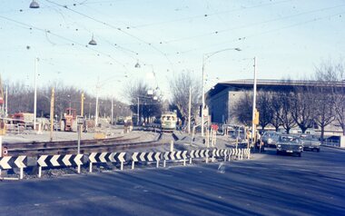 Melbourne Tram Museum
Photograph - Two colour slides - St Kilda Road Trackworks, 1-8-1970
Set of two colour slides showing the intersection of St Kilda Road, City Road and Sturt St. City Road at the start of work to lower City Road under St Kilda Road. The tracks along Sturt St had been diverted by Nolan St (now Southbank Blvd). The photo shows that only one of the tracks had been brought into use, the other still under construction. Photography by Warren Doubleday.Yields information on the start of the works to lower City Road under St Kilda Road 1-8-1970Set of two Anscochrome colour slides, of trackwork to place City Road under St Kilda Road. .1 - SW6 959 on St.-Kilda Rd deviation - shows the Arts Centre and the scale of the deviation. The former tracks into City Road and Sturt St can be seen in the foreground. .2 - SW6 878 - shows the Arts Centre, YMCA building the intersection with City Road and Sturt StHas photographers slide numbers on each slide.st kilda rd, trackworks, city rd, sturt st, sw6 class, tram 959, tram 878, tramways, track -
 Melbourne Tram Museum
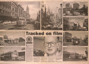
Newspaper, Herald Sun, Tracked on film - Keith Atkinson, 9/1/2001
Item written by Shaunagh O'Connor for the Herald Sun at the time of the publication of a book, "Trams and Streetscapes, Metropolitan Melbourne 1950's 1960's edited by Emile G Badaway and John Sargent and published by Train Hobby Publications. Features photos of W2 231 in Flinders St, T181 in North Fitzroy and Footscray, W6 982 in Bourke St, W2 636 in Market St, W3 667 in Swanston St, Y1 613 in Elizabeth St and X1 677 in Footscray. Features in the centre a photo of the photographer, Keith Atkinson.Yields information about publication of a book, the photographer and his work.Newspaper - centre page titled Tracked on film - Keith Atkinson, from the Melbourne Herald Sun, 9/1/2001 featuring a story on a new book of tram photographs. tramways, trams, w2 class, t class, books, w3 class, x1 class, w2 231, t 181, w6 982, y1 613, w2 636, x1 677 -
 Melbourne Tram Museum
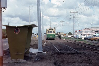
Photograph - Changing the Location of the Essendon Airport terminus, Ron Scholten, 7-10-1976
The original line to the Essendon Aerodrome was constructed in 1943 to serve the airport and aircraft construction. It was funded by the Commonwealth Government. By 1976, patronage to the airport terminus in Vaughan St had dropped, the crossing of the highway to the Tullamarine Airport opened in 1970, was dangerous, and the highway needed to be widened. The new terminus was a short distance to the north between Mathews Ave and the Highway. This series of photographs show the operation of a tram service during the changeover. Trams ran from the Niddrie crossover near Keilor Road to a temporary terminus just short of the worksite, with cars running "bang" road or the wrong way for one trip along either line. This would have been controlled by an Inspector at the Niddrie end. The work was done over a 7-hour period, including changing the overhead over. Work would have been completed after the changeover period. .1 - W5 800 at “temporary” Essendon Airport terminus, Cnr Mathews Ave, Vaughan St. after running “bang” road or the wrong way to this point from the Niddrie or Keilor Road crossover. Curves have been removed.. Has an Inspector chatting to a man with a hat standing alongside the tram. The shelter has a City of Keilor logo on it. .2 - W5 684, taken from the overbridge at the TAA stop - during the changeover of the tracks. Tram running “bang” road from Niddrie to the temporary terminus. .3 - SW5 787, temporary terminus in Mathews Ave, about to return to Niddrie as an “up” car on the “down” line. .4 - MMTB Track gang commissioning and placing rails at the new terminus with scrubber 10 waiting. Overhead in position with overhead for the curves partly removed. Mobile Crane on the left-hand side moving a formwork piece into position .5 - 10W cleaning new track at the new terminus. .6 - Rail Scrubber 10W at work cleaning head of rails where new concrete section. Has a TAA bus on the right side. .7 - W5 783 is about to be the first passenger tram to the terminus, at 3.50 pm About 20 workmen are completing the inbound or up track. .8 - W5 783 about to be the first passenger tram to the terminus, at 3.50 pm About 20 workmen are completing the inbound or up track.Yields information about the last day of the operation of the original Essendon Airport tram line and the works done for the new terminus.Set of 8 Kodachrome cardboard mount colour slides of the relocation of the Essendon Airport tram terminus 7-10-1976, by Ron Scholten. All slides have detailed descriptions on the rear trams, tramways, essendon aerodrome, essendon airport, closure, new tramways, route 59, mmtb, trackwork, w5 800, w5 684, sw5 787, scrubber 10w, w5 783, w5 class, sw5 class, taa airlines, city of keilor -
 Melbourne Tram Museum
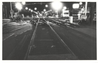
Photograph - Trackwork High St St Kilda, Keith Kings, 17-3-1974
Photo shows the installation of new special work or junction at High St and Brighton Road at Carlisle St St Kilda 17/3/1974. The work was part of the major road widening project of High Street between St Kilda Junction and Carlisle St with the trams relocated into their own reservation. The track was raised 18 inches or about 450mm above the previous road level. The track was brought into use on Monday 18/3/1974.Yields information about the installation of a new junction in 1974 and the methods used.Photograph - Trackwork High St St KildaDetailed description on rear. K S Kings stamp and photo number 130-20. tramways, high st, carlisle st, trackwork, brighton road, junctions -
 Melbourne Tram Museum
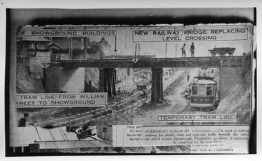
Photograph - Black and White, Epson Road Rail Bridge under construction, Early 1925
Image shows a newspaper photo of the MMTB U Class Tram 203 on temporary track at east side of excavation for underpass in Epson Road Flemington with Racecourse railway line to eliminate level crossing. The road was often closed to all traffic, including trams on race days by the railways. The work was completed in April 1925MMTB U Class trams were built for the former operator NMETL, with the photo showing an early level crossing abolition project. Black and White photo Epson Road Rail Bridge under construction with MMTB U Class tram on temporary track tramways, trams, epson road bridge, u class, flemington, tram 203 -
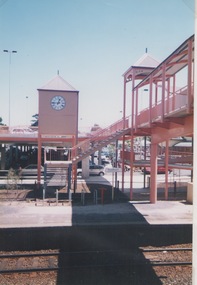 Sunbury Family History and Heritage Society Inc.
Photograph, Shannon Richards, Sunbury Station, March 2001
In 2000 major renovation works were carried out on the Sunbury Bendigo Rail line to accommodate new and larger carriages which were going to replace older trains. Major work at Sunbury included extending the platforms and replacing an old wooden pedestrian bridge with a larger one the included a series of ramps and a clock tower as well as a new pedestrian bridge.A non-digital coloured photograph of a series of ramps over railway tracks with a clock tower. The photograph was an entry in the Junior section of a photographic competition organised by the Sunbury & District Heritage Association in March 2001. sunbury railway station, sunbury, railways, bendigo rail line -
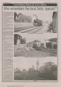 Eltham District Historical Society Inc
Work on paper (item) - Newspaper, The Local Paper, Local Railway History by Lance Adams
Article on local railway history by Lance Adams pubished in "The Local Paper". This article headed:: "Who remembers the local footy 'specials"? discusses special train movements which would be organised to convey locals to neighbouring towns, for example to attend a football match. Article accompanied by three historical photos of locomotives and train tracks.newspaper, yea, alexandra, k154, w256, locomotive, trains, football -
 Marysville & District Historical Society
Work on paper (item) - Poem, Thelma Stucliffe, To The Sir John Franklin Gold Mine From Gooleys Creek, 01-12-2004
A poem that was written about a journey taken by a local miner's daughter to the Sir John Franklin gold mine from Gooleys Creek.A poem that was written about a journey taken by a local miner's daughter to the Sir John Franklin gold mine from Gooleys Creek.sir john franklin gold mine, gooleys creek, stander's track, goulburn river, wood's point, johnstons hill, chinese miners, black friday -
 Ballarat Tramway Museum
Photograph - Geelong Tramway - relaying tram tracks in Aphrasia St., Newtown
Relaying tram tracks at the eastern end of Aphrasia St., Newtowwn, looking east. The location is immediately west of the Pleasant St. intersection, soon after Aphrasia St. was extended from Pleasant St. to Pakington St., so that the three sharp curves for trams into Retreat Road, Pleasant St., and then Aphrasia St., were reduced to one, from Pakington into Aphrasia St. May 1914. Note that sleepers are being used in the construction, as seen in items 9271 and 9214, with tie bars and continuous concrete about 50cm wide under each rail. The overhead is being worked on in two ways; safely with the horse drawn tower wagon, or less so by ladder.,Black and white print on paper.GRS710/.25/1/7 and 25-7 written on the reverse in pencil. The No. 1 in a circle written on reverse in ink.geelong tramway, relaying tram tracks in geelong, sleeper and concrete tram track base