Showing 1049 items matching "trailes"
-
 Healesville and District Historical Society
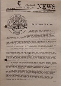
Newsletter (Item) - Volume 1; No. 4, Healesville History News, November 1984, November-1984
Contents: On the trail of a logo Billy Hughes visited Healesville Miss Mabel Sutherland Morwell Hodges A boy from Coranderrk Pam Firth resigns Historic Photographic exhibition catalogue and program Echoes of Healesville Victoria 150th anniversary programme - Plus moreThe first newsletter of the Society was issued July 1984 and has been published continuously ever since on a quarterly basis. The collection provides a valuable resource about the Society's activities, office bearers and committee members and, especially, many relevant items of local historical interest. -
 Bendigo Historical Society Inc.
Document - ANZAC COLLECTION: MUSICAL DITTIES FOR ANZAC CONCERTS BENDIGO AND GOORNONG 2015, 24th January, 2015
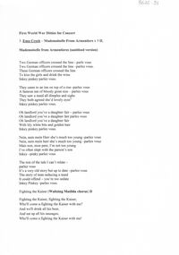
Words of concert ditties for Anzac Concert held at Goornong Soldiers' Memorial Hall on 24th. January 2015; and Capital Theatre, View St., Bendigo on 24th. April 2014. Includes Mademoiselle from Armentiers, F, Wee Doch and Doris G., If you were the only girl in the world, Who were you with last night, Fighting the Kaiser; The trail of the Lonesome Pine. 8 pages.Peter Ellismilitary, world war 1, concert ditties -
 Ballarat Tramway Museum
Photograph - Black & White Photograph/s, W.H. Watts, 10/01/1912 12:00:00 AM
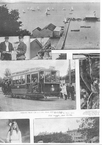
Yields information about the opening of the Geelong tram system and the events of the day, including the respective mayoresses driving decorated trams.Black and white reproduction photograph of a page from the Now Magazine, 18.1.1912 issue featuring photographs of Geelong and in particular a photograph of Geelong No. 4 on a trail run, 10.1.1912, at 5am. Photo credited to W.H. Watts. Image 1 - Copy 1 - has the reproduction of part of the page. Image 2 - Copy 2 - part print of the page, featuring the tramcar - printed on Hewlett Packard paper.Copy 1 - "10)2" in the top left hand corner, a William Scott address label on the rear in ink "10) middle pic car 4". Copy 2 - a William Scott address label on the rear and "10)" trams, tramways, geelong, first tram, testing, commissioning, tram 4 -
 Melbourne Tram Museum
Negative - Melbourne Town Hall cable trams, c1905
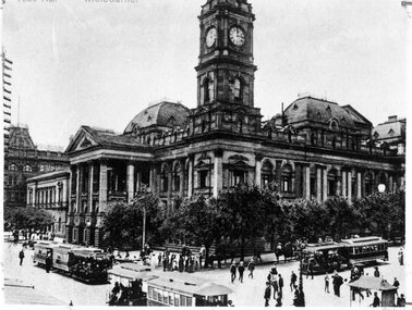
Photograph of the Melbourne Town Hall at the intersection of Collins and Swanston St with three cable tram sets, including one in Swanston St with a second trailer or trail car. The grip car is very well loaded. c1905. See item 8448 for a coloured postcard of this view.Yields information about cable trams and the Melbourne Town Hall c1905.Copy negative of a photographtrams, tramways, cable trams, mto co, swanston st, collins st, trailers -
 Frankston RSL Sub Branch
Drift Recorder, W & G, A M Drift Recorder MKII, 1930 - 1939
Purpose built mechanical calculation machine for determining the drift of aircraft when operating in crosswind conditions. This device has an eyepiece and a prismatic periscope for viewing a distant feature being tracked. This device has calibrated rotary scales for height, speed (in KNOTS and MPH), and an adjustment to preset the 'crab angle' of the aircaft for cross wind compensation. The device can be opened for cleaning or maintenance purposes. Refer to the following extracts for information about bomb drift: "Crosswinds brought into the bombing problem a new factor, "drift" In order to fly a given ground track in a crosswind, an aircraft had to "crab" into the wind; the angle formed between the aircraft's true heading and its ground track was called the "drift angle" In a crosswind, the bomb would impact directly behind the aircraft and along its longitudinal axis at the moment of release. But this meant that the bomb would strike the ground at some point downwind of the aircraft's ground track. Thus, in order to score a hit, the bomber had to fly a ground track that ran upwind of the target." "Air resistance acting on a bomb after release caused it to lag behind the drop point and hit somewhere behind the bomber. The distance from a point beneath the aircraft at the instant of bomb impact to the point of bomb impact was called "trail." Trail increased as the bomber's airspeed increased or as its altitude increased. Furthermore, since different bombs encountered different resistance in the air, trail was also a factor of bomb shape."A. M. Drift Recorder MKII REF. No 6B/190 No 2668/41 X/ 3606 3E4H28 -
 Greensborough Historical Society
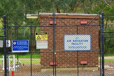
Photograph - Digital Image, Air Navigation Facility, Montmorency, 2018, 1930s
Air Navigation Facility, Palara Court Montmorency, is made up of a tower and brick building surrounded by wire fences. It is sited in parkland at the end of Palara Court close to the Plenty River Trail. Warning signs are placed on the fences, including: "This facility is provided for the control and guidance of aircraft".Digital copy of colour photographair navigation facility, air control, palara court montmorency -
 Greensborough Historical Society
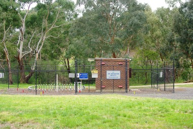
Photograph - Digital Image, Marilyn Smith, Air Navigation Facility, Montmorency, 2018. Long view, 04/12/2018
Air Navigation Facility, Palara Court Montmorency, is made up of a tower and brick building surrounded by wire fences. It is sited in parkland at the end of Palara Court close to the Plenty River Trail. Warning signs are placed on the fences, including: "This facility is provided for the control and guidance of aircraft".Digital copy of colour photographsair navigation facility, air control, palara court montmorency -
 Greensborough Historical Society
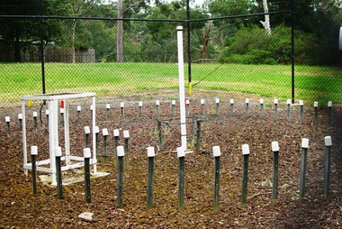
Photograph - Digital Image, Marilyn Smith, Air Navigation Facility, Montmorency, 2018. Close up, 04/12/2018
Air Navigation Facility, Palara Court Montmorency, is made up of a tower and brick building surrounded by wire fences. It is sited in parkland at the end of Palara Court close to the Plenty River Trail. Warning signs are placed on the fences, including: "This facility is provided for the control and guidance of aircraft".Digital copy of colour photographair navigation facility, air control, palara court montmorency -
 Greensborough Historical Society
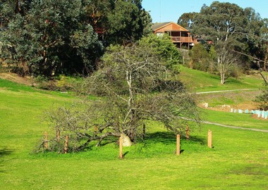
Photograph - Digital Image, Marilyn Smith, Batman Apple Tree Greensborough 2019, 02/07/2019
The Batman Apple Tree is said to be the oldest apple tree in Victoria and came from the remnants of John Batman's orchard after his death. In the 1840s, this area was Frederick Flintoff's orchard on land called Brancepeth Farm. The tree is located along the Plenty River Trail in Greensborough. 3 colour digital photographsplenty river trail, batman apple tree, john batman, frederick flintoff, brancepeth farm -
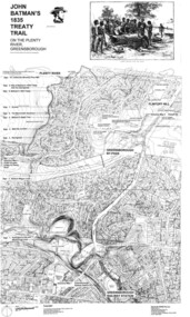 Greensborough Historical Society
Map, Dennis Ward, John Batman's 1835 Treaty Trail on the Plenty River, 2010_
Map of the Plenty River through Greensborough and surrounding areas, annotated with historic places. Prepared by Dennis Ward, this map shows places of interest with historic markers for a proposed Heritage Trail along the Plenty. This was a joint project of Dennis Ward, Rotary Greensborough and Nillumbik Historical Society.This map shows many places of interest along the Plenty River. Large laminated map, including land subdivisions and street names.plenty river heritage trail -
 Eltham District Historical Society Inc
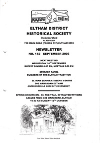
Newsletter, Newsletter, No. 152 September 2003
Contents: • Next meeting, Speaker Panel: Builders of the Eltham Tradition • September Meeting • Visitors to Eltham • Spring Excursion – On the Trail of Walter Withers • Acquisitions; A report by Harry Gilham • Andrew Ross Museum • Clement Byrne Christesen OBE, AOM 1911-2003 • More News The Shire of Eltham Historical Society was formed in October 1967. The first newsletter of the Society was issued May 1978 and has been published continuously ever since on a bi-monthly basis. With the cessation of the Shire of Eltham in late 1994, the Society's name was revised to Eltham District Historical Society and this name first appeared with issue No. 103, July 1995. The collection of the Society's newsletters provides a valuable resource on the history of the Society's activities, office bearers and committee members, guest speakers and subjects of historical interest pertinent to the former Shire of Eltham and the Eltham District.A4 photocopied newsletter distributed to membersnewsletter, eltham district historical society, shire of eltham historical society -
 Eltham District Historical Society Inc
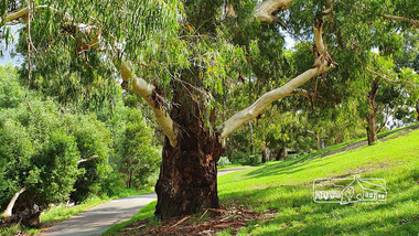
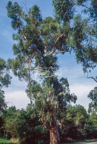
Photograph, Alison Delaney, Significant Eucalyptus tree, Diamond Creek Trail, Alistair Knox Park, Eltham, 21 Feb 2020
This tree is a significant tree located beside the Diamond Creek Trail in Alistair Knox Park. It was identified as the same tree in earlier photos from the 1980s. This images was taken just before the COVID-19 pandemic hit and the tree also has been tagged with grafitti on its trunk.alistair knox park, diamond creek trail, grafitti, significant tree -
 Eltham District Historical Society Inc
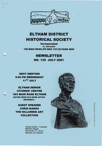
Newsletter, Newsletter, No. 139 July 2001
Contents: • Next meeting, guest speaker; Chris Marks: The Nillumbik Art Collection • July Meeting • Gawa Wurundjeri Aboriginal Resource Trail • Society Happenings • Andrew Ross Museum • Some Other Brief News Items • Poems and Writings of Gwendoline Margaret Baker – nee Bowes The Shire of Eltham Historical Society was formed in October 1967. The first newsletter of the Society was issued May 1978 and has been published continuously ever since on a bi-monthly basis. With the cessation of the Shire of Eltham in late 1994, the Society's name was revised to Eltham District Historical Society and this name first appeared with issue No. 103, July 1995. The collection of the Society's newsletters provides a valuable resource on the history of the Society's activities, office bearers and committee members, guest speakers and subjects of historical interest pertinent to the former Shire of Eltham and the Eltham District.A4 photocopied newsletter distributed to membersnewsletter, eltham district historical society, shire of eltham historical society -
 Ballarat Tramway Museum
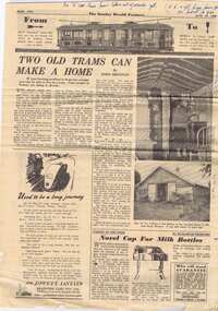
Newspaper, Sydney Herald, "Two old trams can make a home", Jun. 1950
Sydney Sunday Herald article titled "Two old trams can make a home" features of 25/6/1950, page 2 of 16 has article on re-using Sydney tram cars as the basis for houses, includes 3 photos, mentions housing shortage, page 8 has feature on start of NSW Rail construction (1850) and photo of NSW steam locos includes many as and articles of the time. Record updated and image added 21/9/2013.p2 - "No 'O' class have been taken out of service / N,K or L/P have been sold or burnt so far" notes on photos - interior/exterior - "Steam Trail Cars". p8 "Saw 5802 go through Blacktown Sunday 28-6-1950".trams, tramways, sydney trams, houses, tramcar disposals, nswgr -
 Melbourne Tram Museum
Ephemera - Ticket, The Met, "Neighbourhood ticket - Caulfield Moorabbin - Sandringham", 1982
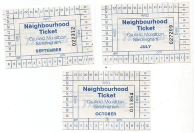
Paper or pasteboard "Neighbourhood ticket - Caulfield Moorabbin - Sandringham" - issued on the trams as part of the Trail Neighbourhood system late 1982. Refer to http://www.robx1.net/victkt/zone123/html/nhd.htm - accessed 21-7-2018 - see htd2899note.pdf for full details. Three copies held - 011354 - used 17/10 at 3pm. 022312 - used 1/9 at 7pm 027209 - used 7/9 at 8pm.trams, tramways, mta, neighbourhood tickets, tickets, caulfield -
 Eltham District Historical Society Inc
Slide - Photograph, Manna Gum, Main Road, Eltham South, c.Apr. 1993
Estimated to date from 1870-180, this large Manna Gum (now deceased 2022) on the northern side of Main Road just south of the Main Road Bridge over the Diamond Creek, Eltham South, c.1993. Diamond Creek Trail can be see on opposite side of the road. 35mm colour positive transparency (1 of 22) Mount - Kodak EktachromeProcess Date "Apr M"eltham south, main road, significant tree, main road bridge, manna gum -
 Eltham District Historical Society Inc
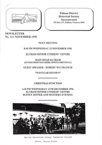
Newsletter, Newsletter, No. 111 November 1996
Contents: • Next meeting, guest speaker; Robert Wuchatsch: Westgarthtown • November Meeting • Christmas Function • Society Headquarters • President’s Report • Spring Excursion • Eltham Heritage Trail • Nillumbik Heritage Study • More News • A Punt Across the Yarra at Eltham? • Former Eltham Shire Office Site The Shire of Eltham Historical Society was formed in October 1967. The first newsletter of the Society was issued May 1978 and has been published continuously ever since on a bi-monthly basis. With the cessation of the Shire of Eltham in late 1994, the Society's name was revised to Eltham District Historical Society and this name first appeared with issue No. 103, July 1995. The collection of the Society's newsletters provides a valuable resource on the history of the Society's activities, office bearers and committee members, guest speakers and subjects of historical interest pertinent to the former Shire of Eltham and the Eltham District.A4 photocopied newsletter distributed to membersnewsletter, eltham district historical society, shire of eltham historical society -
 Eltham District Historical Society Inc
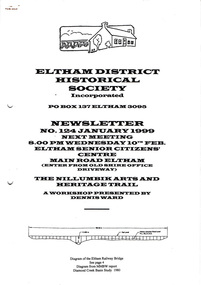
Newsletter, Newsletter, No. 124 January 1999
Contents: • Next meeting, The Nillumbik Arts and Heritage Trail; A workshop presented by Dennis Ward • February Meeting • Society Program 1999 • The Other Elthams • Annual General Meeting • Andrew Ross Museum • The Eltham Railway Bridge • Some Other Snippets • 1976 ‘Save the Trestle Bridge’ Poster The Shire of Eltham Historical Society was formed in October 1967. The first newsletter of the Society was issued May 1978 and has been published continuously ever since on a bi-monthly basis. With the cessation of the Shire of Eltham in late 1994, the Society's name was revised to Eltham District Historical Society and this name first appeared with issue No. 103, July 1995. The collection of the Society's newsletters provides a valuable resource on the history of the Society's activities, office bearers and committee members, guest speakers and subjects of historical interest pertinent to the former Shire of Eltham and the Eltham District.A4 photocopied newsletter distributed to membersnewsletter, eltham district historical society, shire of eltham historical society -
 Ballarat Tramway Museum
Film - Movie Film & Box, Kodak, 1960
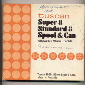
Yields information in movie film format of Ballarat trams in 1960, how the system operated and was used by people., Yields information in movie film format of Ballarat trams in 1960, how the system operated and was used by people.Movie film - 8mm, approx. 17.5 mins, with leader strip on a plastic reel, within a black and white plastic box, titled "Ballarat No. 1. 1960" contained with a cardboard box, 'Tuscan Super 8 and Standard 8 Spool and Can' . Has been transferred to DVD - see Reg item 4100 as Segment No. 1. Filmed and made by Ben Parle. Also transferred to DVD by Rod Cook Oct. 2015, via Roger Greenwood for use in his DVD, "The City of Ballarat Trams, Gardens & Gold" of 2016. See Reg Item 6883. Synopsis: based on time. 0:00 Starts with bogies cars crossing railway level crossing (34?, 39?) 0:30 SEC Logo 0:45 Ballarat Station sign and intro “Some City Scenes” 0:49 35 turning from Lydiard St Nth to Sturt St towards Grenville St with Commonwealth Bank in view. and then 42 returning 1:19 42 showing Mt Pleasant, turns from Sturt St into Lydiard St Nth 1:53 Tramway road works in Lydiard St Nth, near intersection with Mair St with Jelbart Road roller in use, starts with an SEC roadworks sign. 2:12 39 passing the works out bound to Lydiard St Nth. 2:46 Good view of the roller working before 35 arrives. 3:01 35 passing the works in bound with 3:29 14 crossing Lydiard St in Sturt St, towards Grenville St 3:47 Trams in City Loop 3:55 21 coming up the hill 4:04 31 entering Bridge St from Sturt St with Bucks Head Hotel in the background. 4:27 Overhead work at corner of Sturt and Lydiard, with view of the sign at the City terminus “Trams leave here for Sebastopol, Gardens, View Point.” 4:34 Passengers getting off and then onto 38, ex Lydiard St Nth at city terminus including a young lady wearing gloves and a wheeling a pram hurriedly the photographer. A number of other prams in the view as well as. The Conductor helps to unload the pram. 5:07 41 proceeding up Sturt St, appears to have just rained. 5:26 11 using the Dawson St crossover, with a motor car doing a U turn as well. 6:00 14 descending Sturt St towards the City, filmed at Dawson St. 6:11 Title “The Gardens via Drummond St North Line” 6:16 19 showing Victoria St, turning from Drummond St Nth into Sturt St. 6:28 30 inbound in Drummond St Nth, approach and trailing shots. Trailing shot ahs the hospital in the background. 6:49 31 outbound, Drummond St Nth, approach and trailing shots, trees are in autumn colours. 7:04 12, inbound Drummond St Nth, with Macarthur St in the background, stopping to pick up a lady, approach and trailing shots and then entering the Mill St crossing loop. 7:53 14 outbound in Drummond St Nth, dropping a lady passenger off and then turning into Macarthur St and then tram going away. 8:37 View of overhead junction at View Point Jtn. 8:45 View of “Cars Stop Here” sign and pole sign “To City Only” 8:55 30 inbound in Wendouree Parade, stops to pick up passenger, and then a trailing shot of tram entering Macarthur St loop 9:37 View of “Cars Stop Here”, “End of Section” and timetable boards at Haddon St. 9:50 34, pausing at Haddon St and then proceeding towards depot – approach and trailing shots, with “Warning Oncoming Trams” sign in shot. 10:27 “Warning Oncoming Trams” sign 10:32 34 crossing 12 at the Martin Ave loop 10:48 39? Wendouree Parade, near Barrett Ave, stopping and letting off passengers. 11:24 30 passing depot junction and then trailing shot of it entering Tram Sheds or Depot Loop and then proceeding towards the City. 12:11 Shot of the “Caution Beware of Trams” sign at the depot. 12:14 25 stopping at depot junction and then trailing shot of it going toward Forrest St. 12:47 12 passing Depot Junction, trailing shot. 13:07 Shot of :Electricity Supply Department, Ballarat Branch” sign at depot. 13:13 View of a destination showing “Depot” on a bogie tram 13:15 Title “Some Depot Scenes” 13:19 View of a trolley pole and then 13 leaving the depot through the gates, destination showing “View Point”. 13:54 View of trolley pole and then 32 stopping at the depot gates. 14:08 12 (Sunny view) running out onto Wendouree Parade and then a bogie tram approaching Depot Loop. 14:43 View of 42 running in with a single trucker behind in Wendouree Parade, and another single trucker running out. 15:02 Title “Some Scenes in the Gardens” 15:05 25 running through the Gardens, approach and trailing shots, near our Depot Junction. 15:55 View of “No Parking East of Loop” sign 15:59 View of overhead and then trackwork (with points removed), but overhead still in position at the Old Gardens Loop or Gardens South Loop and then 12 entering the loop from the south and then a trailing shot looking along the Parade. 16:33 View of “Cars Stop Here” and “End of Section” and then timetable boards at Gardens Loop. 16:55 View of 34 leaving the loop 17:14 Title “The End”Written labels giving title information on outside of box.trams, tramways, ballarat, sebastopol, lydiard st north, victoria st, mt pleasant, sturt st west -
 Federation University Historical Collection
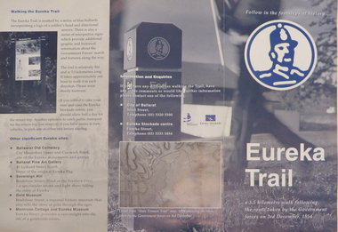
Brochure, Eureka Trail, c2000
The brochure gives information on the Eureka Stockade which took place on 03 December 1854. The Eureka trail aimed at enhancing the Eureka experience and was developed in 1996. It was managed by the City of Ballarat with funding assistance form the State and Federal governments. Much of the work was undertaken under the New Work Opportunity Programme.Blue and white brochure highlighting relevant Eureka Stockade site. The brochure includes a map showing the route the Government forces took on their way to the Eureka Stockade as well as sites of interest to Eureka which are marked by blue bollards. The brochure was presented by the City of Ballarat and the Eureka Stockade centre.eureka, eureka stockade, diggers' trail, trooper's trail, eureka stockade centre, city of ballarat -
 Wycheproof & District Historical Society Inc.
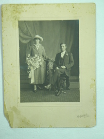
Photograph, Richards & Co, Studio Portrait of Patrick Ryan and Elizabeth H Forrester's wedding, 1918
Patrick Ryan married 'Ellie' Forrester of Towaninnie in 1918 at Inglewood Vic. 'Ellie' daughter of Richard & Ellen Forrester (nee Dauber) of Towaninnie Vic. This photo depicts the more sombre dress worn for weddings during the war years.Studio portrait of Elizabeth Helena Forrester 'Ellie', bride is wearing a two piece ankle length suit, court shoes and carrying a large bouquet of flowers with trailing ribbons. Organdie lace trimmed blouse fastened with a brooch, a smart brimmed hat and necklace completed the elegant ensemble. Patrick Ryan groom, single breasted suit with waistcoat, white bow tie and gloves, button hole and lace up boots.Right hand corner - on embossed card mount "Richards & Co Ballarat". Reverse - "For Auntie Ellen with love Ellie & Pat" hat, studio portrait, forrester, wedding, 1918, bouquet, bride, groom, two piece tailored suit, single breasted suit waistcoat, towaninnie -
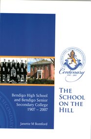 Bendigo Historical Society Inc.
Book - BSSC COLLECTION: THE SCHOOL ON THE HILL
Book ''the School On The Hill'' Bendigo High Schol and Bendigo Senior Secondary College 1907-2007 by Janette M. Bomford. Ninety eight pages book published for the Centenary of the school. Also included a Bendigo Advertiser article from August 10, 2007 title: Time capsule reveals gold and two small brochures: Bendigo Senior Secondary College History Trail and Centenary Celebrations 5-7 October 2007.education, bendigo, bssc -
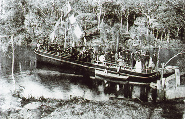 Lakes Entrance Historical Society
Photograph - S.S. Tambo, 1885 c
Black and white photograph showing S S Tambo, trail trip 1882 on Tambo River shows large crowd on boat, bunting flying from mast, two small row boats either side. Thick bush on far bank. Post and rail fence going into the water lower right hand corner. Camp oven or boiler and camp fire lower left hand corner. Tambo Upper Victoriaboats and boating, tourism, waterways -
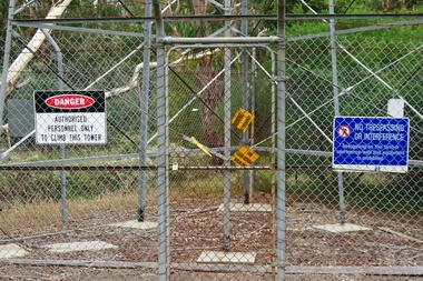 Greensborough Historical Society
Photograph - Digital Image, Marilyn Smith, Air Navigation Facility, Montmorency, 2018. Signs at tower, 04/12/2018
Air Navigation Facility, Palara Court Montmorency, is made up of a tower and brick building surrounded by wire fences. It is sited in parkland at the end of Palara Court close to the Plenty River Trail. Warning signs are placed on the fences, including: "This facility is provided for the control and guidance of aircraft". This photograph shows signs at tower.Digital copy of colour photographair navigation facility, air control, palara court montmorency -
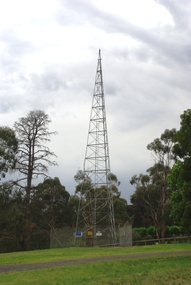 Greensborough Historical Society
Photograph - Digital Image, Marilyn Smith, Air Navigation Facility, Montmorency, 2018. Tower, 04/12/2018
Air Navigation Facility, Palara Court Montmorency, is made up of a tower and brick building surrounded by wire fences. It is sited in parkland at the end of Palara Court close to the Plenty River Trail. Warning signs are placed on the fences, including: "This facility is provided for the control and guidance of aircraft". This photograph shows the tower on the site.Digital copy of colour photographsair navigation facility, air control, palara court montmorency -
 Eltham District Historical Society Inc
Newsletter, Newsletter, No. 157 July 2004
Contents: • Next meeting, Speaker Panel: On the Heritage Trail • Eltham Major Activity Centre • Maroondah Aqueduct Across the Plenty River • Eltham East Choir • President’s Notes • Alan Marshall’s Bungalow • Robert Bruce Ness 1917-2004 incl Ness Family History by Joy Ness • More News The Shire of Eltham Historical Society was formed in October 1967. The first newsletter of the Society was issued May 1978 and has been published continuously ever since on a bi-monthly basis. With the cessation of the Shire of Eltham in late 1994, the Society's name was revised to Eltham District Historical Society and this name first appeared with issue No. 103, July 1995. The collection of the Society's newsletters provides a valuable resource on the history of the Society's activities, office bearers and committee members, guest speakers and subjects of historical interest pertinent to the former Shire of Eltham and the Eltham District.A4 photocopied newsletter distributed to membersnewsletter, eltham district historical society, shire of eltham historical society -
 Eltham District Historical Society Inc
Photograph, Peter Pidgeon, Site of the former Village Pond, Main Road, Eltham, 2 Aug. 2022
View looking looking southwest from the Diamd Creek Trail opposite Dalton Street on Main Road where the former pond was situated. The pond was drained by Council in 1932 due to concerns of mosquitoes, etc against the wishes of long standing residents such as Thekla Jarrold (39 years) and John Clark (22 years).Comparative photo taken 2022 with one taken from same location over 100 tears earlier by noted local photographer John Henry ClarkBorn Digitaleltham, dalton street, main road, diamond creek trail, village pond, wingrove park trail -
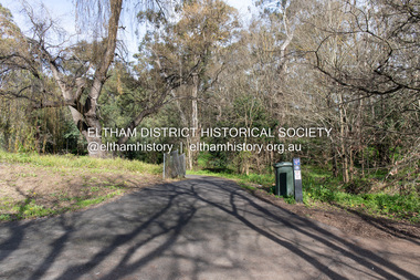
 Eltham District Historical Society Inc
Photograph, Peter Pidgeon, Site of the former Village Pond, Main Road, Eltham, 2 Aug. 2022
View looking looking southwest from the Diamd Creek Trail opposite Dalton Street on Main Road where the former pond was situated. The pond was drained by Council in 1932 due to concerns of mosquitoes, etc against the wishes of long standing residents such as Thekla Jarrold (39 years) and John Clark (22 years).Born Digitaleltham, dalton street, main road, diamond creek trail, village pond, wingrove park trail -
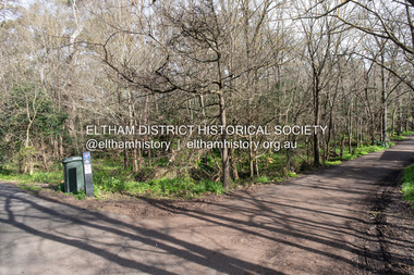 Eltham District Historical Society Inc
Photograph, Peter Pidgeon, Site of the former Village Pond, Main Road, Eltham, 2 Aug. 2022
View looking looking southwest from the Diamond Creek Trail opposite Dalton Street on Main Road where the former pond was situated. The pond was drained by Council in 1932 due to concerns of mosquitoes, etc against the wishes of long standing residents such as Thekla Jarrold (39 years) and John Clark (22 years).Born Digitaleltham, dalton street, main road, diamond creek trail, village pond, wingrove park trail -
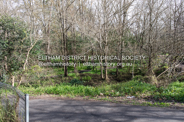
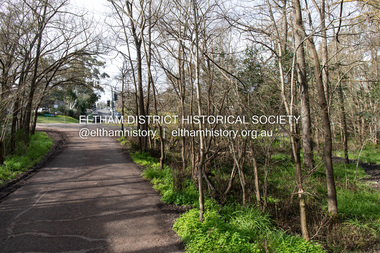 Eltham District Historical Society Inc
Photograph, Peter Pidgeon, Site of the former Village Pond, Main Road, Eltham, 2 Aug. 2022
View looking looking east along the Wingrove Park Trail opposite Dalton Street on Main Road where the former pond was situated. The pond was drained by Council in 1932 due to concerns of mosquitoes, etc against the wishes of long standing residents such as Thekla Jarrold (39 years) and John Clark (22 years).Born Digitaleltham, dalton street, main road, diamond creek trail, village pond, wingrove park trail