Showing 477 items
matching tree bridge
-
 Benalla Art Gallery
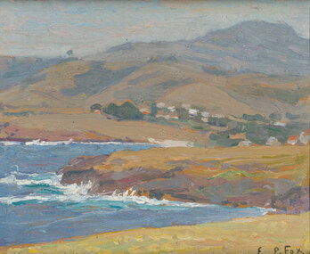
Painting, E. Phillips FOX, Untitled, Not dated
Born: Fitzroy, Victoria, Australia 1865; Lived and worked: France and England 1887-1892, France 1901-1913; Died: Melbourne, Victoria, Australia 1915ImpressionismGift of anonymous donor, in memory of Mr and Mrs R. R Webster, 1981Seascape with buildings, trees and hills. Stained timber frame.Recto: Signed "E.P.Fox" in black oil in l.r.c of composition; Not dated; Not titled painting, seascape, sea, hills, landscape, buildings, waves -
 Benalla Art Gallery
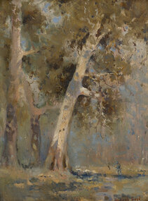
Painting, Penleigh BOYD, Gum trees, Not dated
Born: Westbury, Wiltshire, England 1890; Arrived: Melbourne, Victoria, Australia 1893; Died: Warragul, Victoria, Australia 1923ImpressionismLedger Gift, 1981Rural landscape with large trees and small figure with gold brushed timber frame.Recto: Signed "Penleigh Boyd." in red oil in l.r.c of composition; Not dated; Not titledpainting, landscape, trees, figure -
 Benalla Art Gallery
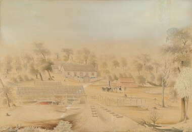
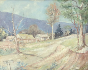
Watercolour, William TIBBITS, Mr J. Thompson's star sawmills, Staffordshire Reef, Not dated
Born: 1837; Arrived Australia c. 1866; Died: Sydney, New South Wales, Australia 1906ColonialLedger Gift, 1982Rural landscape with farmhouse and outbuildings surrounded by trees, two figures by a horse and wagon. Stained wooden frame.Recto: Signed "Drawn by W.TIBBITS. artist NEIL ST. Ballarat" in blue ink in lower centre of sheet edge; Titled 'Mr J.Thompson’s. / Star Saw Mills Staffordshire Reef.' in blue ink in lower centre of sheet; Not datedwatercolour, colonial, rural, trees, buildings, wheels, horse, animal -
 Benalla Art Gallery
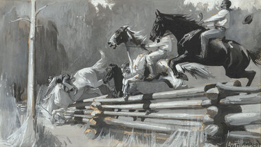
Painting, George W. LAMBERT, Shearer's Sunday, 1899, 1899
Born: St Petersburg, Russia 1873; Arrived: Sydney, New South Wales, Australia 1887; Lived and worked: England, France, Wales, Egypt, Palestine 1900-1921; Died: Cobbity, New South Wales, Australia 1930NationalismGift of Mrs E.E. Ledger, 1982Rural landscape with four horses and riders jumping a fence. Image is in black and white colour. Dark stained, gold and grey brushed timber frame.Recto: Signed "GEO.W.LAMBERT" in black watercolour in l.r.c of composition; Not dated; Not titledpainting, rural, horses, animals, figures, fence, jump, tree -
 Benalla Art Gallery
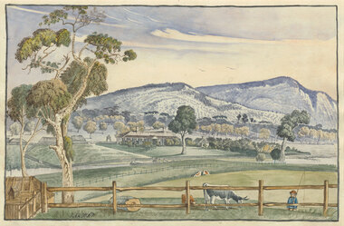
Watercolour, Elizabeth PARSONS, Cameron's Station, Pyrenees, c. 1890
Born: Isleworth, Middlesex, England 1831; Arrived: Melbourne, Victoria, Australia 1870; Died: Melbourne, Victoria, Australia 1897VictorianGift of Mrs E.E. Ledger, 1982Rural landscape with house, fences, trees hills, a creek and a small figure carrying a fishing line. Thin, dark blue grey brushed timber frame.Recto: Signed "PARSONS" in black watercolour in l.l.c of composition; Not dated; Not titledwatercolour, landscape, tree, mountains, animals, cows, figures, fence, creek, colonial, buildings -
 Benalla Art Gallery
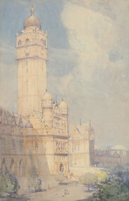
Watercolour, Arthur STREETON, The Imperial Institute, Kensington, London, c. 1900
Born: Mount Duneed, Victoria, Australia 1867; Lived and workd: England 1897-1919; Died: Olinda, Victoria, Australia 1943EdwardianGift of Mrs E.E. Ledger, 1982Sunny urban landscape with impressive building with large towers facing a street with figures and trees.Thin gold brushed timber frame.Recto: Signed "Arthur Streeton." in brown watercolour in l.l.c of composition; Not dated; Not titledwatercolour, building, sky, figures, trees, tower -
 Benalla Art Gallery
Watercolour, Charles BENNETT, Pioneer’s cottage, Mornington, 1891
Born: South Yarra, Victoria, Australia 1869; Died: Mornington, Victoria, Australia 1930VictorianLedger Gift, 1985Sunlit rural landscape with buildings, figures, wagon, trees, water, reflections and a hill. Gold brushed ornate timber frame.Recto: Signed and dated "C. S. BENNETT / 1891" in brown watercolour in l.r.c; Not titledwatercolour, landscape, riverscape, house, trees, water, reflection -
 Benalla Art Gallery
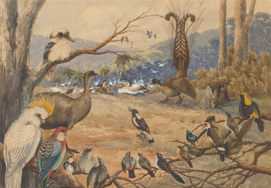
Watercolour, Neville CAYLEY, Congress of the birds, 1910
Born: Yamba, New South Wales, Australia 1886; Died: Sydney, New South Wales, Australia 1950NationalismLedger Gift, 1985Clearing in a rural landscape with many different types of birds. There are palm trees and treed hills in the background. Stained timber frame.recto: Signed and dated "Neville.W.Cayley -10-" in black watercolour in l.r.c of composition; Not titledwatercolour, landscape, birds, magpie, cockatoo, kookaburra, blue wren, rosella, field, tree -
 Benalla Art Gallery
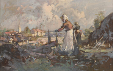
Painting, W. B. MCINNES, Volendam fisher folk, Not dated
Born: St Kilda, Victoria, Australia 1889; Died: Melbourne, Victoria, Australia 1939ImpressionismLedger Gift, 1985Expressive brushstrokes in muted colours of two figures fishing in foreground with buildings, tower and trees in background. Timber frame.Recto: Signed "McINNES" in dark brown oil in l.r.c of composition; Not dated; Not titledpaintings, rural, buildings, figures, clouds -
 Benalla Art Gallery
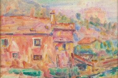
Watercolour, John RUSSELL, Morning light, Liguria, 1920
Born: Darlinghurst, New South Wales, Australia 1858; Lived and worked: England, Spain, France, Italy, New Zealand 1881-1923; Died: Randwick, New South Wales, Australia 1930ImpressionismLedger Gift, 1985Expressive brightly coloured brushstrokes of rural farm houses and trees. Gold brushed timber frame.Recto: Not signed, not dated, not titledwatercolour, buildings, chimney, impressionist -
 Benalla Art Gallery
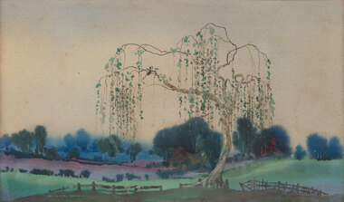
Watercolour, William Blamire YOUNG, Japanese willow, Not dated
Born: Londesborough, Yorkshire, England 1862; Arrived: Sydney, New South Wales Australia 1885; Lived and worked: England 1893-1896; Died: Montrose, Victoria, Australia 1935VictorianLedger Gift, 1985Rural landscape with large weeping tree, fence, rolling hills, line of trees and sky. Grey rubbed from gold gesso timber frameRecto: Signed "BLAMIRE YOUNG-" in white watercolour in l.l.c of composition; Not dated; Not titledwatercolour, landscape, trees, fence -
 Benalla Art Gallery
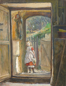
Watercolour, Julian ASHTON, Girl at the gate, 1878
Born: Addlestone, Surrey, England 1851; Arrived: Melbourne, Victoria, Australia 1878; Died: Bondi, New South Wales, Australia 1942VictorianLedger Gift, 1985Interior scene with small figure standing at doorway to outside fenced garden. Unframed.Recto: Signed and dated "J. R. ASHTON / 1877" in red watercolour in l.l.c of compositionwatercolour, interior, exterior, child, door, fence, tree -
 Benalla Art Gallery
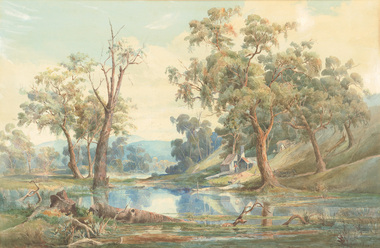
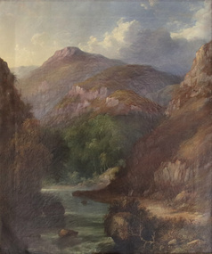
Painting, J. H. CARSE, Mountain River, 1866
Born: Edinburgh, Scotland c.1818; Arrived: Melbourne, Victoria, Australia c.1867; Died: Sydney, New South Wales, Australia 1900VictorianGift of Mrs E.E. Ledger, 1985Rural landscape with dirt track, narrow stream, trees and steep mountains. Gold brushed and painted timber frame.Recto: Signed and dated “J H Carse / 1866” in brown oil, l.r.c of composition; Not titled painting, landscape, mountains, river, clouds, sky, trees -
 Benalla Art Gallery
Watercolour, Nicholas CHEVALIER, Swiss scene, 1886
Born: St Petersurg, Russia 1828; Arrived: Melbourne, Victoria, Australia 1854; Lived and worked: Switzerland 1845-1848, Germany 1851-1854, Australia 1854-1865, New Zealand 1865-1866, England 1870-1902; Died: London, Middlesex, England 1902RomanticismGift of Mrs E.E. Ledger, 1985View from rustic house with two figures overlooking lake surrounded by mountains and trees. Grey brushed stained timber.Recto: Signed and dated "N.Chevalier. / 1886" in brown watercolour in l.l.c of composition; Not titledwatercolour, landscape, waterscape, building, trees, mountains, water, cabin, sunset -
 Benalla Art Gallery
Watercolour, Ellis ROWAN, Springtime in the Dandenongs, Not dated
Born: Melbourne, Victoria, Australia 1848; Lived and worked: New Zealand 1866-1877, New Zealand, United Kingdom, United States 1892-1905; Papua New Guinea 1916 and 1918; Died: Macedon, Victoria, Australia 1922NationalismLedger Gift, 1987Dense bush landscape with pink flowers, yellow trees and tall gum trees. Gold brushed timber frame. Recto: Signed "Ellis Rowan" in brown watercolour in l.l.c of composition; Not dated; Not titledwatercolour, landscape, trees, shrubs, flowers, autumn -
 Benalla Art Gallery
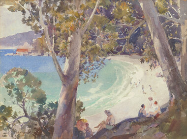
Watercolour, B. E. MINNS, Bathers at the beach, 1935
Born: Dungog, New South Wales, Australia 1864; Lived and worked: England and France 1895-1915; Died: Taronga Park, New South Wales, Australia 1937InterwarLedger Gift, 1987Figures relaxing under trees overlooking beach with buildings and hills in the distance. Thin gold brushed timber frame.Recto: Signed and dated "B.E.MINNS / 1935" in brown watercolour in l.l.c of composition; Not titled watercolour, seascape, trees, figures, beach, buildings -
 Benalla Art Gallery
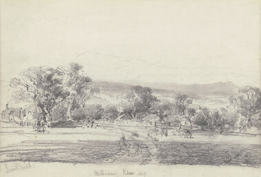
Drawing, Louis BUVELOT, Melbourne Kew (Yarra Glen), 1869
Born: Morges, Vaud, Switzerland 1814; Lived and worked: Brazil 1835-1852; Arrived: Melbourne, Victoria, Australia 1865; Died: Melbourne, Victoria, Australia, 1888ColonialLedger Gift, 1987Rural landscape with two animals beside a track leading towards buildings and outbuildings surrounded by trees with hills in distance. Timber frame.Recto: Signed "Louis Buvelot" in grey pencil in l.l.c of composition; Titled and dated 'Melbourne Kew 1869' in grey pencil in lower centre of compositiondrawing, landscape, figures, trees, colonial, road, animals -
 Benalla Art Gallery
Painting, Frederick MCCUBBIN, The artist's home, South Yarra, Not dated
Born: Melbourne, Victoria, Australia 1855; Died: Melbourne, Victoria, Australia 1917Heidelberg SchoolLedger Gift, 1987House on top of hill in rural landscape with sloping hill to a pond and trees and grasses in foreground. Copper brushed timber frame.Recto: Signed "F. McCubbin" in brown oil in l.r.c of composition; Not dated; Not titledpainting, waterscape, hills, house, landscape, water, impressionist -
 Benalla Art Gallery
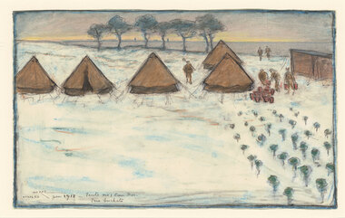
Drawing, Iso RAE, The Canadian Field Hospital, Etaple, 1918
Born: Melbourne, Victoria, Australia 1860; Lived and worked: France 1887-1932, England 1932-1940; Died: Brighton, Sussex, England 1940World War IGift of Mrs E.E. Ledger, 1987Drawing depicting a field hospital with tents and trees lining a snowy field and figures working at sunrise. Limed timber gallery frame with white window mountRecto: Signed, titled and dated 'ISO RAE / ETAPLES Jan 1918 – Tents no I Can. Hos. / fire buckets" in grey pencil in l.l.c of compositiondrawing, landscape, figures, trees, structures, tents, sunrise -
 Benalla Art Gallery
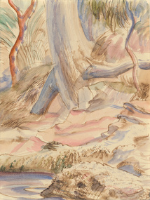
Watercolour, Eric WILSON, Berowra, 1940
Born: Annandale, New South Wales, Australia 1911; Lived and worked: England and France 1937-1940; Died: Sydney, New South Wales, Australia 1946ModernismGift of Mrs E.E. Ledger, 1987Watercolour depicting a creek bed with rock in the foreground. Unframed, hinged taped with two pieces of white tape to cream mat boardRecto: Not signed, not dated, not titledwatercolour, landscape, trees, water, rock, roots -
 Benalla Art Gallery
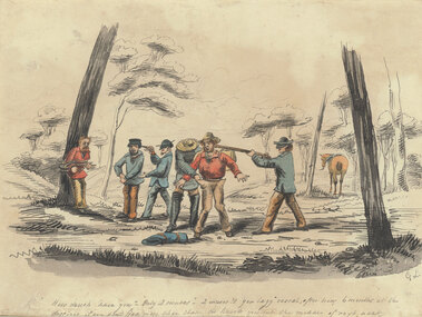
Watercolour, George LACY, Hold up, Not dated
Born: London, Middlesex, England c.1817; Arrived: Sydney, New South Wales, Australia 1842; Died: Bathurst, New South Wales, Australia 1878ColonialLedger Bequest, 1993Watercolour with ink, depcicting two men being robbed at gunpoint in the bush. Immitation timber frame with black painted edge, gold brushed internal window edge, and off white window mountRecto: Signed "G.L." in grey watercolour in l.r.c of composition; Narrative as part of work, '"How much have you” – “only 2 ounces” – “2 ounces?!! You lazy rascal, after 6 months at the diggings if you don’t find more than that I’ll knock you into the middle of next week”' written in grey watercolour across the lower edge of the composition; Not dated; Not titledwatercolour, figures, animals, trees, gun, horse, theif -
 Benalla Art Gallery
Painting, John Ford PATERSON, Miner’s cottage, 1884
Born: Dundee, Forfarshire,Scotland 1851; Arrived: Melbourne, Victoria, Australia 1872; Lived and worked: Scotland 1875-1884; Died: Carlton, Victoria, Australia 1912VictorianLedger Bequest, 1993Oil on canvas on composition board, depicting a rural landscape and miner's commune off a dirt road. Gold brushed timber frame with decorative gesso edges and corners Recto: Signed and dated “J FORD PATERSON / 1884” in blue oil in l.r.c of composition; Not titledpainting, landscape, house, trees, path, road -
 Benalla Art Gallery
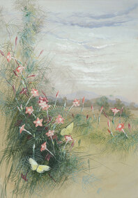
Watercolour, Ellis ROWAN, Butterflies and flowers, Not dated
Born: Melbourne, Victoria, Australia 1848; Lived and worked: New Zealand 1866-1877, New Zealand, United Kingdom, United States 1892-1905; Papua New Guinea 1916 and 1918; Died: Macedon, Victoria, Australia 1922VictorianLedger Bequest, 1993Watercolour and gouache on paper depicting pink flowers and yellow butterflies in a sparse field. Gold brushed timber frame with off white window mountRecto: Signed "Ellis Rowan" in red watercolour in l.l.c of composition; Not dated; Not titledwatercolour, landscape, flowers, sky, clouds, trees, butterflies -
 Benalla Art Gallery
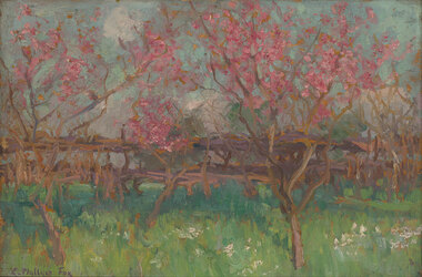
Painting, E. Phillips FOX, Spring blossoms, Not dated
Born: Fitzroy, Victoria, Australia 1865; Lived and worked: France and England 1887-1892, France 1901-1913; Died: Melbourne, Victoria, Australia 1915ImpressionismMajor Basil MacNay Bequest, Gift of Arts Victoria, 1998Oil on wood panel depicting pink spring blossoms in a field. Carved gold brushed timber frameRecto: Signed "E. Phillips Fox" in purple oil in l.l.c of composition; Not dated; Not titledpaiting, landscape, garden, trees, cherry blossom, fence, impressionist -
 Benalla Art Gallery
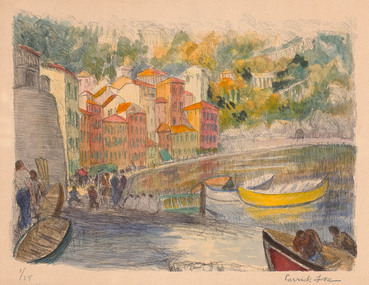
Print, Ethel CARRICK, (Houses. Water. Boats), Not dated
... Waterscape Boats Houses Bridge Figures Europe Trees Hill Water Recto ...Born: Uxbridge, Middlesex, England 1872; Arrived: Melbourne, Victoria, Australia c.1914; Lived and worked: France 1905-1913, Australia: 1908 and 1913, Europe, Middle East and Asia 1916- c.1936; Died: Melbourne, Victoria, Australia 1952ImpressionismMajor Basil MacNay Bequest, Gift of Arts Victoria, 1998Hand-coloured lithograph depicting colourful buildings, boats and figures along shoreline. UnframedRecto: Signed "Carrick Fox" in black pencil in l.l.c of composition; "1/25" in black pencil in l.r.c of compositon; Not dated; Not titledprint, waterscape, boats, houses, bridge, figures, europe, trees, hill, water -
 Benalla Art Gallery
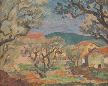
Painting, Rupert BUNNY, (Landscape, France), Not dated
Born: St Kilda, Victoria, Australia 1864; Lived and worked: England and France 1884 - 1933; Died: Melbourne, Victoria, Australia 1947ImpressionismGift of Mr Alan Harris in memory of his wife Lynette Harris (née Burnell), 2004Oil painting on board depicting rural landscape with trees and farmhouses. Gold brushed timber frame with decorative gesso corners.Recto: Not signed, not dated, not titled painting, landscape, buildings, tree, impressionist, hills -
 Benalla Art Gallery
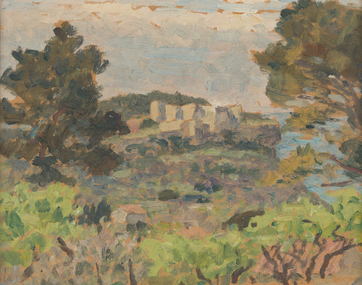
Painting, Rupert BUNNY, (Coastal landscape), Not dated
Born: St Kilda, Victoria, Australia 1864; Lived and worked: England and France 1884 - 1933; Died: Melbourne, Victoria, Australia 1947ImpressionismGift of Mr Alan Harris in memory of his wife Lynette Harris (née Burnell), 2004Oil painting depicting coastal landscape with buildings and cliffs in background. Gold brushed timber frame with decorative gesso cornersRecto: Not signed, not dated, not titled painting, landscape, sea, trees, impressionist, buildings, cliff -
 Benalla Art Gallery
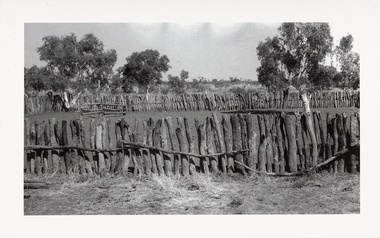
Photograph, Sidney NOLAN, ‘Central Australia’ series, 1949
Born: Carlton, Victoria, Australia 1917; Lived and worked: England 1953-1992; Died: London, Middlesex, England 1992Post WarGift of the Friends of the Benalla Art Gallery, 2005 Black and white photogaph of makeshift horse arena. Unframed in archival folder.Recto: Not signed, not dated, not titledphotograph, fence, hill, rural, arid, tree, building, figures, fence, bush, child, woman, rock painting, paddock -
 Benalla Art Gallery
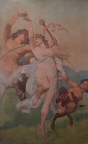
Painting, Julian ASHTON, Neo-classical allegory, c. 1890
Born: Addlestone, Surrey, England 1851; Arrived: Melbourne, Victoria, Australia 1878; Died: Bondi, New South Wales, Australia 1942NeoclassicismGift of Mr Wayne N. Kratzmann, 2005painting, mythical, figures, centraur, child, faun, tambourine, grapes, trees, sky, nude, dancing -
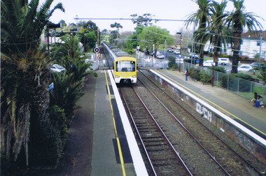 St Kilda Historical Society
Photograph, Ethan Lawrence, 2009
Photograph taken in 2009Colour photograph, mountedI took this picture on the bridge at Ripponlea train station. It shows what the station is like. Two platforms (City, Sandringham) Palm trees that are old and were established with the English people came and settled over Australia. By Ethan Lawrenceripponlea, glen eira road, railway, ripponlea station, ripponlea state school