Showing 10390 items
matching plan
-
 Rutherglen Historical Society
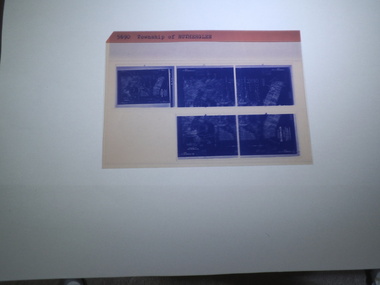
microfiche sheet, Victorian Land Tiltes Office, Township of Rutherglen
Town layout of Beechworth5 Aperture Sized microfilms on a single microfiche in a paper sleeve plan, town, boundries, lots, roads -
 Rutherglen Historical Society
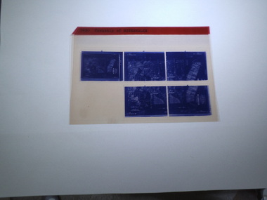
microfiche sheet, Victorian Land Tiltes Office, Township of Rutherglen
Town layout of Beechworth5 Aperture Sized microfilms on a single microfiche in a paper sleeve plan, town, boundries, lots, roads -
 Rutherglen Historical Society
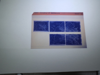
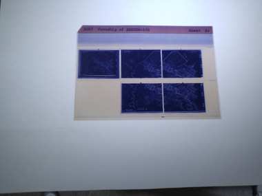
microfiche sheet, Victorian Land Tiltes Office, Township of Beechworth
Town layout of Beechworth5 Aperture Sized microfilms on a single microfiche in a paper sleeve plan, town, boundries, lots, roads -
 Rutherglen Historical Society
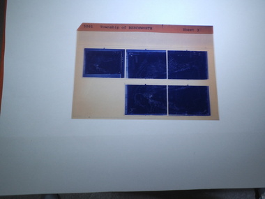
microfiche sheet, Victorian Land Tiltes Office, Township of Beechworth
Town layout of Beechworth5 Aperture Sized microfilms on a single microfiche in a paper sleeve plan, town, boundries, lots, roads -
 Rutherglen Historical Society
microfiche sheet, Victorian Land Tiltes Office, Township of Beechworth
Town layout of Beechworth5 Aperture Sized microfilms on a single microfiche in a paper sleeve plan, town, boundries, lots, roads -
 Federation University Historical Collection
Booklet - Report, Regional College Development Planning Paper, 1976
Ballarat School of Mine's 'Regional College Development Plan' for the Lydiard Street Campus. It includes minutes of meeting in 1976.ballarat school of mines, ballarat regional college, graham beanland, ballarat technical school, ballarat girls'high school, mount clear technical high school, tertiary orientation program, campus plan, smb campus plan -
 Phillip Island and District Historical Society Inc.
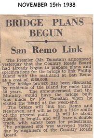
Newspaper clippings, 15/11/1938
Newspaper articleArticle stating Country Roads Board had begun to prepare plans for the San Remo Phillip Island Bridge.local history, documents, newspapers, bridges, phillip island, black & white newspaper clipping, mr dunstan premier of victoria, country roads board -
 Phillip Island and District Historical Society Inc.
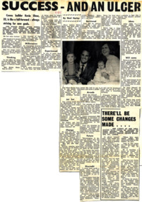
Newspaper Clipping, 7/11/1968
Article from a collection of newspaper clippings from October 1968 to July 1971Article about Kevin Shaw and his building success on Phillip Island and future plans for many projects on the island.phillip island, kevin shaw, builder -
Glenelg Shire Council Cultural Collection
Letter - Letter - Vanda Savill to Frances Hall, n.d
Two photocopies of a letter from Vanda Savill to Frances Hall, Historic Buildings Council, Department of Planning and Housing.historic buildings, heywood, vanda savill -
Glenelg Shire Council Cultural Collection
Flyer - Flyer - Maretimo, Portland Victoria, n.d
Foolscap size flyer, yellow, burgundy print. Information for visitors to 'Maretimo' Portland, including floor plan of building -
4th/19th Prince of Wales's Light Horse Regiment Unit History Room
Booklet, Arbuckle Waddell Pty Ltd, Operations Military Training Pamphlet No 23 Part 1 General Principles, Fighting Troops & Their Characteristics, 1939
Soft covered booklet, covering the principles of war, tactics, planning, command & control etc and the fighting troops and their characteristics. tactics, training, world war 2 -
4th/19th Prince of Wales's Light Horse Regiment Unit History Room
Booklet, Land/Air Warfare Pam 4 Airborne & Air Transported Operations 1953, 1953
A soft covered booklet as a guide to all Army and RAF officers on the planning or conduct of airborne operations. With amdt No 1WO Code No 8785airborne operations -
 Eltham District Historical Society Inc
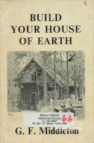
Book, George Frederick Middleton, Build your house of earth : a manual of earth wall construction / G.F. Middleton, 1979
"This book was "the bible" of mud brick and Pise builders in the 1950s"Paperback; xiii, 130 p., [8] p. of plates : ill. (some col.), diagrs., plans ; 25 cm.ISBN 0908136722 (pbk.)buildings, mudbrick, mud brick construction -
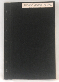 Orbost & District Historical Society
plans, 1966?
These survey plans are a useful research tool.A flat green fabric folder with a white label with "SNOWY RIVER FLATS" hand-written in black. It contains plans.plans-survey snowy-river-flats department-crown-lands-victoria -
Ringwood and District Historical Society
Plans - Building, Browning, George et al, Heathmont Pre-School architects plans. 1999, Feb-99
Photocopy of architects plans of Heathmont Pre-School Centre. +Additional Keywords: Secomb, Frank, F.R.A.I.A. / Ritchie, Alan -
Federation University Historical Collection
Report, Echuca Moama Tourism Planning and Development Strategy, c1996
Report compiled by three students of 'Tourism Planning and Development' at Ballarat University College (later Federation University Australia).victorian tourism industry, tourism, alumni, echuca, moama, hopwood's ferry, murray river, goulburn river, campaspe river, gaming -
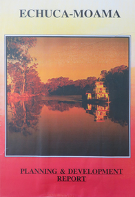 Federation University Historical Collection
Report, Echuca Moama Tourism Planning and Development Strategy, 1993, 06/1993
Report compiled by four students of 'Tourism Planning and Development' at Ballarat University College (later Federation University Australia).victorian tourism industry, tourism, alumni, echuca, moama, hopwood's ferry, murray river, goulburn river, campaspe river, gaming, port of echuca -
Bendigo Historical Society Inc.
Map - BENDIGO PARISH PLAN
Bendigo Parish Plan Central Bendigo. Canvas with Canvas typed edges. Taken from George Black's maps -
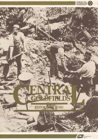 Bendigo Historical Society Inc.
Document - CENTRAL GOLDFIELDS RESTORATION FUND
A document titled ' Central Goldfields Restoration fund.' Ministry for Planning and Environment. A Commonwealth/State Bicentennial Project. 1988.bendigo, planning, goldfields, central goldfields, document, restoration fund, bendigo, history, bendigo history, heritage, bendigo heritage, central goldfields, place, gold, victoria, australian bicentenery -
 Bendigo Historical Society Inc.
Document - CERTIFICATE OF TITLE
Certificate of titles and its subdivision plans for land bought by George Lansell in Toorak. Dated 27th August 1874.melbourne -
Port Melbourne Historical & Preservation Society
Photograph - Participants, Bayside Open Planning Forum, Aug 1992
8 lasercopies of photos of participants in the Bayside Open Planning Forum, held between 6 and 10 August 1992town planning, built environment, bayside development action group, bdag, joh drury, lyn allison, neil robinson, david raynor, leanne matheson, robin edmond, bayside open planning forum, wendy morris, neil beddoe, city engineers -
Port Melbourne Historical & Preservation Society
Document - Specification, Williamstown Road, Derham Street to Raglan Street, Port Melbourne, 14 Mar 1893
Written specification of works attached to plan of Williamstown Road from Derham Street to Raglan Street. (67.1) 1893.A.V. Heath (Town Surveyor). J.J. Bartlett (Mayor).engineering - roads streets lanes and footpaths, arthur victor heath, town clerks, james john bartlett, mayors -
Port Melbourne Historical & Preservation Society
Document - Specification, Metalling and channelling Liardet Street from Esplanade East to Esplanade West, 14 Mar 1893
Specifications (102.1) & Plan (102.2) for metalling and channelling Liardet Street from Esplanade East to Esplanade West 1893..Both signed by J.J. Bartlett. (Mayor).engineering - roads streets lanes and footpaths, town planning, town clerks, mayors, arthur victor heath, james john bartlett, liardet street -
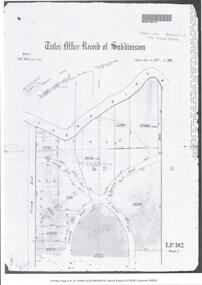
Bendigo Historical Society Inc.
Map - KANGAROO FLAT SUBDIVISION, 26/11/1900
Map: Plan of Subdivision at Kangaroo flat, Parish of Sandhurst, County of Bendigo ( number 149 in Map Cupboard 1)map, bendigo, parish plan, kangaroo flat, parish of sandhurst, county of bendigo -
Bendigo Historical Society Inc.
Map - PLAN OF THE TOWNSHIP OF SANDHURST(PHOTOCOPY)
Map: Photocopy of a plan of the Township of Sandhurst. Dated 26 July 1854 ( number 141 in Map Cupboard 1)map, bendigo, city streets, township of sandhurst, early bendigo, city streets -
Bendigo Historical Society Inc.
Map - NERRING, 15/06/1937
Map: Parish of Nerring, County of Bendigo. Parish plan Canvas backed ( number 139 in Map Cupboard 1)map, bendigo, rural, nerring, county of bendigo -
Bendigo Historical Society Inc.
Map - PARISH OF SANDHURST SHEET 5A, 1970
Map: Parish of Sandhurst Sheet 5A, County of Bendigo. Parish plan ( number 161 in Map Cupboard 1)map, bendigo, parish plan, parish of sandhurst, county of bendigo -
Bendigo Historical Society Inc.
Map - EAGLEHAWK (PART), 22/01/1882
Map: Parish plan showing area Eastward from Lightning Hill ( number 205 in Map Cupboard 1)map, bendigo, parish plan, eaglehawk, lightning hill -
Bendigo Historical Society Inc.
Map - NERRING. SHEET ?, Circa 1894
Map: Nerring, Part ( number unreadable), County of Bendigo. Parish plan ( number 190 in Map Cupboard 1)map, bendigo, parish plan, nerring -
Bendigo Historical Society Inc.
Map - RAYWOOD, 18/09/1930
Map: Township of Raywood, Parish of Neilborough,County of Bendigo. Parish plan (number 270 in map cupboard 1)map, bendigo, township, raywood