Showing 10390 items
matching plan
-
 Bendigo Historical Society Inc.
Map - GOORNONG, 1/10/1906
Map: Town of Goornong, Parish of Goornong, County of Bendigo. Parish plan (number 269 in map cupboard 1)map, bendigo, township, goornong -
Bendigo Historical Society Inc.
Map - RAVENSWOOD, April 6th 1872
Map: Township of Ravenswood. Parish plan, has a 1913 calendar as a backing (number 266 in map cupboard 1)map, bendigo, township, ravenswood -
Bendigo Historical Society Inc.
Map - PORTION OF SANDHURST, 27/01/1877
Map: Hand draughted parish plan, showing a portion of the City of Sandhurst ( number 225 in Map Cupboard 1)map, bendigo, parish plan, sandhurst -
Bendigo Historical Society Inc.
Map - SANDHURST (PART), Circa 1880's
Map: Parish plan sowing an area along Specimen Hill Rd. ( number 211 in Map Cupboard 1)map, bendigo, parish plan, specimen hill rd. sandhurst , bendigo -
Bendigo Historical Society Inc.
Map - TARNAGULLA SHEET 1, Examined 25/08/1926
Map: Tarnagulla Sheet 1, Counties of Gladstone and Bendigo. Parish plan (number 304 in map cupboard 1)map, gladstone, parish plan, tarnagulla -
Bendigo Historical Society Inc.
Map - PARISH OF MARONG ALLOTMENTS, No date Visible
Map: Parish of Marong Allotments, County of Bendigo. Parish plan Blueprint (number 286 in map cupboard 1)map, bendigo, allotments, marong allotments -
Bendigo Historical Society Inc.
Map - FOSTERVILLE MAP, 19/08/1897
Map: Township of Fosterville, Parish of Ellesmere, County of Bendigo. Parish plan (number 277 in map cupboard 1)map, bendigo, township, fosterville, ellesmere -
Bendigo Historical Society Inc.
Map - YARRABERB, 17/12/1937
Map: Township of Yarraberb, Parish of Yarraberb, County of Bendigo. Parish plan (number 274 in map cupboard 1)map, bendigo, township, yarraberb -
Bendigo Historical Society Inc.
Map - NEWBRIDGE, August 17th 1875
Map: Township of Newbridge, Parish of Tarnagulla, County of Bendigo. Parish plan (number 272 in map cupboard 1)map, bendigo, township, newbridge -
Bendigo Historical Society Inc.
Map - AXEDALE, 12/07/1909
Map: Township of Axedale, Parish of Axedale, County of Bendigo. Parish plan (number 271 in map cupboard 1)map, bendigo, township, axedale -
Bendigo Historical Society Inc.
Map - CRAVEN'S ALLOTMENTS , NEW CHUM, No date visible
Map: Craven's Allotments, New Chum. Hand Draughted plan showng the corner of McKenzie and Rose streets Bendigo.map, bendigo, allotments, cravens allotments, new chum -
Bendigo Historical Society Inc.
Map - NEILBOROUGH, 21/01/1875
Map: Parish of Neilborough, County of Bendigo. Hand Draughted Parish plan. Map dated 21/1/1875.map, bendigo, parish plan, neilborough -
Bendigo Historical Society Inc.
Map - CALAVIL, 28/08/1874
Map: Country Lands, Parish of Calavil, County of Bendigo. Parish plan (number 334 in map cupboard 1)map, bendigo, country lands, country lands, parish of calavil -
Tatura Irrigation & Wartime Camps Museum
Book, Adolf Wilke, 15 September 1944 - 1 May 1946
Surveyors book compiled by POW Adolf Wilke who was lecturer in surveying at Camp 13, Murchison.Handmade hard cover, hand stitched book consisting of figures and plans in ink and pencil. 69 numbered pages.adolf wilke, surveying, camp 13 surveying -
Tatura Irrigation & Wartime Camps Museum
Architect plans, Tatura Methodist Church, 1964
Methodist Church was built and opened on present site (Uniting) in 1959. These extensions completed the building as it now stands.1 of 2 copies (L3264) of complete architects plans and specifications for extensions to Tatura Methodist Church building, 1964. methodist church tatura, alexander harris & assoc. -
Tatura Irrigation & Wartime Camps Museum
Architect plans, Tatura Methodist Church, 1964
Methodist Church was built and opened on present site (Uniting) in 1959. These extensions completed the building as it now stands.1 of 2 copies (L3263) of complete architects plans and specifications for extensions to Tatura Methodist Church building, 1964. methodist church tatura, alexander harris & assoc. -
Lakes Entrance Regional Historical Society (operating as Lakes Entrance History Centre & Museum)
Book, LERHS, Public Works Department Correspondence, 1989|2013
Containing background information about the planning construction and opening of the artificial entrance from the ocean to the Gippsland Lakes Victoriawaterways, civil engineering, topography -
Lakes Entrance Regional Historical Society (operating as Lakes Entrance History Centre & Museum)
Book, Dept of Primary Industries Fisheries Publisher, Auditor Generals Report East Gippsland Shire Council Proposed sale of Lakes Entrance Property, 2007
This management plan is to specify the objectives, stratagies and performance measures for recreational fishing activities within the Lake Tyers ReserveISBN 1448 1693fish, waterways, legislation -
Whitehorse Historical Society Inc.
Document, City of Nunawading Forward Planning Special Committee, 1/07/1994 12:00:00 AM
Notice and agenda of Forward planning Committee includes items re Amalgamation submission and proposed names for merged city.Notice and agenda of Forward planning Committee includes items re Amalgamation submission and proposed names for merged city.Notice and agenda of Forward planning Committee includes items re Amalgamation submission and proposed names for merged city.city of nunawading, local government, amalgamations -
Whitehorse Historical Society Inc.
Letter - Correspondence, Abattoir Property, 1937
Letters between City of Box Hill and Shire of Blackburn and Mitcham re sale of abattoir property with a plan of the subdivision.Letters between City of Box Hill and Shire of Blackburn and Mitcham re sale of abattoir property with a plan of the subdivision.Letters between City of Box Hill and Shire of Blackburn and Mitcham re sale of abattoir property with a plan of the subdivision.city of box hill, shire of blackburn and mitcham, abattoirs paddock, aspinall's estate, woodhouse grove, box hill north, aspinall road, box hill north, koonung creek, land subdivision -
Whitehorse Historical Society Inc.
Article, Access grant setback, 1976
Nunawading Learning Exchange suffered a financial loss when it missed out on a further Australian Assistance plan grant.Nunawading Learning Exchange suffered a financial loss when it missed out on a further Australian Assistance plan grant.Nunawading Learning Exchange suffered a financial loss when it missed out on a further Australian Assistance plan grant.city of nunawading, learning exchanges, morris, jo, reach out for kids, nunawading learning exchange -
Whitehorse Historical Society Inc.
Article, School finally opens, 1992
Orchard Grove Primary School has finally opened after nearly six years planning and several 'hiccups'.Orchard Grove Primary School has finally opened after nearly six years planning and several 'hiccups'.Orchard Grove Primary School has finally opened after nearly six years planning and several 'hiccups'.orchard grove primary school, turner, dennis, mirabooka primary school, blackburn south primary school, no. 4035, warrawong primary school -
Whitehorse Historical Society Inc.
Article, Hostel welcomes first residents
After five years of planning and development the Nunawading Community Hostel has taken in its first residents.After five years of planning and development the Nunawading Community Hostel has taken in its first residents. With photo.After five years of planning and development the Nunawading Community Hostel has taken in its first residents.retirement homes and villages, nunawading community hostel, wroe, chris, martin, jan, cavill, margaret, williams, pat, livingstone road, vermont south, no 39 -
Whitehorse Historical Society Inc.
Document, Plans and Specifications, 1948
House Plans and SpecificationsHouse Plans and Specifications for A.H. Schultz and Sons at 26 Owen Street, Mitcham. Approved 15 Dec 1948.House Plans and Specifications plans, owen street, mitcham, no. 26, schultz, a.h. & sons -
 Whitehorse Historical Society Inc.
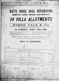
Document, Hampton Court Estate
Plan of subdivision Hampton Court EstatePlan of subdivision Hampton Court Estate Whitehorse Road, Nunawading 1882. Original in Vale Maps LaTrobe LibraryPlan of subdivision Hampton Court Estate hampton court estate, byrne vale & co. -
Whitehorse Historical Society Inc.
Map, Schwerkolt Museum Extension 2010, 1/06/2010 12:00:00 AM
Plans for construction of an extension of the museum building of the Schwerkolt Cottage & Museum Complex (Visitor Centre).Plans for construction of an extension of the museum building of the Schwerkolt Cottage & Museum Complex (Visitor Centre). Lovell Chen, Architects.Plans for construction of an extension of the museum building of the Schwerkolt Cottage & Museum Complex (Visitor Centre).schwerkolt cottage & museum complex, museum building -
 Whitehorse Historical Society Inc.
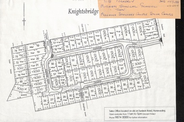
Map, Knightsbridge Estate, Nunawading, Ca 1997 - 1998
Plan of subdivision of former Mitcham Technical School and later Mullauna Secondary College Senior Campus - Knightsbridge Estate.land subdivision, knightsbridge estate, mitcham technical school, mullauna secondary college, senior campus, cherrybrook close, nunawading, knightsbridge avenue, sunnyside avenue, crest grove, dunlavin road, mitcham, carter avenue, humphreys avenue -
Whitehorse Historical Society Inc.
Document, Crown Grant Register, 10/05/1999
Crown Grant Register - General Law - Parish of Nunawading, 1854 - 1858. Lands Department plan of Parish, 1864.land settlement, victoria. lands department, blood, robert, blood, thomas, burrell, charles, clisby, william, cook, charles, cousens, james, dickensen, william, harding, william, hedding, william, holland, john, jones, william, kefford, richard, lobb, john, morgan, robert rowland, morton, william, o'conner, patrick, orr, joseph, polak, nelson, riley, patrick, smith, l l dr, tranter, william, whitman, francis, williams, william, wilks, joseph, wilson, william, wilton, edward -
 Whitehorse Historical Society Inc.
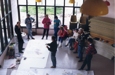
Photograph, Foyer of Nunawading Arts & Entertainment Centre, 1988
Coloured photo of Crafts People discussing Plans for Bicentenary Leadlight Mural in Foyer of Nunawading Arts & Entertainment Centre.nunawading arts centre, bicentenary leadlight mural, arrowsmith, ted -
 Whitehorse Historical Society Inc.
Map - Nunawading scaled Map, Nunawading, 1864
Parish plan of Nunawading, Lands Department, 1864, showing names of first purchasers of land. Copy also at NP215.parish of nunawading, land settlement, maps