Showing 10978 items matching " plan."
-
 Bendigo Historical Society Inc.
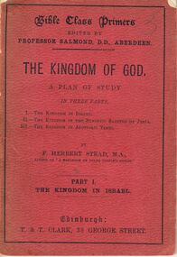
Book - THE KINGDOM OF GOD
Book, Les Gillies Collection, A small red soft covered book titled '' The Kingdom Of God''. A plan of Study in 3 parts. -
 Bendigo Historical Society Inc.
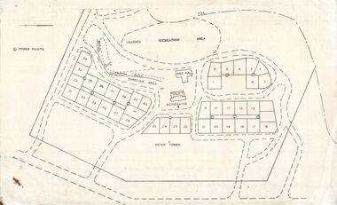
Document - STATE RIVERS AND WATER SUPPLY COMMISSION : EPPALOCK RECREATIONAL AREA PLAN?
Photocopied plan of power points for a recreational area, possibly Eppalock foreshore recreational area?. No title, and undated. With other Eppalock documents.state infrastructure, water supply, coliban system, state rivers and water supply commission. coliban system. eppalock. -
 Port Melbourne Historical & Preservation Society
Flyer - Invitation to planning meeting re campaign against converting the Railway Reserve to a road, Anne Callaghan, 19 Dec 1988
Friends of the Park was established to campaign against the proposal to turn the Railway Reserve into a major road to service the proposed Bayside development. Anne Callaghan was the convenor.Handwritten photocopied invitation to a planning meeting to campaign against converting the Railway Reserve to a major road, an aspect of the 'Bayside' redevelopment, 1988public action campaigns, societies clubs unions and other organisations, transport, parks and gardens, town planning - proposals shelved - bayside, anne callaghan, friends of the park, railway reserve -
Port Melbourne Historical & Preservation Society
Plan - Port Melbourne Yacht Club reconstruction, Taylor Howden Pty Ltd, Architects, c. 1990
Clubhouse burned 14 February 1990 and was rebuilt with volunteer labour over many years (opened 1998)Plan of Port Melbourne Yacht Club clubhouse reconstruction 1990 - pmyc, sketch of elevations of new clubhouse; faded almost to illegibilitybuilt environment - recreational facilities, societies clubs unions and other organisations, port melbourne yacht club, pmyc, taylor howden pty ltd -
Port Melbourne Historical & Preservation Society
Document - Specification, Tramway, Normanby Road, Ingles Street to Boundary Street, Port Melbourne, 14 Mar 1893
Written specification for works attached to plan of tramway in Normanby Road from Ingles Street to Boundary Street (Reg 66.1), 1893.A.V. Heath (Town Surveyor) J.J. Bartlett (Mayor)engineering - roads streets lanes and footpaths, transport - tramways, town planning, town clerks, mayors, arthur victor heath, james john bartlett -
Port Melbourne Historical & Preservation Society
Plan - Williamstown Road, Derham Street to Raglan Street, Port Melbourne, 14 Mar 1893
Plan of Williamstown road from Derham street to Raglan street. (67.1), together with written specification of works attached. (67.2), 1893.A.V. Heath (Town Surveyor). J.J. Bartlett (Mayor).engineering - roads streets lanes and footpaths, arthur victor heath, town clerks, james john bartlett, mayors -
Port Melbourne Historical & Preservation Society
Document - Specification, Unnamed street, Engineering Department, Town of Port Melbourne, Mar 1893
Specification (single, blue-ruled foolscap sheet) for "unnamed street" (later Edwards, Morley) Loan Works 1893, plan no11engineering - roads streets lanes and footpaths, arthur victor heath, town clerks, james john bartlett, mayors -
Port Melbourne Historical & Preservation Society
Document - Specification, Metalling and chanelling, Clark Street from Graham Street to Poolman Street, Engineering Department, Town of Port Melbourne, 14 Mar 1893
Specification for metalling channelling Clark Street from Graham Street to Poolman Street Loan Works 1893; relates to plan 96.2Signed by JJ Bartlett (Mayor)engineering - roads streets lanes and footpaths, arthur victor heath, town clerks, james john bartlett, mayors -
Port Melbourne Historical & Preservation Society
Plan - Metalling and channelling Clark Street from Graham Street to Poolman Street, Engineering Department, Town of Port Melbourne, 14 Mar 1893
Plan for metalling channelling Clark Street from Graham Street to Poolman Street Loan Works 1893; relates to specification 96.1Signed by JJ Bartlett (Mayor)engineering - roads streets lanes and footpaths, arthur victor heath, town clerks, james john bartlett, mayors -
Port Melbourne Historical & Preservation Society
Document - Reports, Department of Infrastructure, C5 amendment to Port Phillip Planning Scheme, Department of Infrastructure, 1999
The C5 Amendment aimed to create a framework for built form and development controls in the Port Melbourne Mixed Use Area undergoing conversion to residential development. Heritage overlays to protect heritage areas were also under review.Developer submissions to an independent Panel reviewing the C5 amendment to the Port Phillip Planning Scheme, 1999 Report from Department of Infrastructuretown planning, built environment - civic, heritage, becton, fox hay timber and hardware pty ltd -
Port Melbourne Historical & Preservation Society
Document - Submission, C5 amendment to the Port Phillip Scheme, 1999
Documents submitted by the City of Port Phillip to the Panel reviewing the C5 Amendment to the Port Phillip Planning Scheme, Aug/Sep 1999town planning, built environment, c5 amendment, port melbourne mixed use growth area -
Port Melbourne Historical & Preservation Society
Plan - Port Melbourne, MMBW, 1987
Very large MMBW plan of Port Melbourne 1987 made up of several sections taped together; drains indicated in blackPMH&PS stamp on backengineering - canals and drainage, mmbw, melbourne and metropolitan board of works -
Port Melbourne Historical & Preservation Society
Plan - Sandridge, 1860
Original would have belonged to Joseph Turner, City Valuer 19th century and grandfather of member Ken Turner, who now holds original that he loaned to us for copying in 1998.Photocopy made from 1860 plan of Sandridge with proposals for various lots beyond the Lagoon, beyond the railway and even on the Railway Reservetown planning, built environment, joseph turner, land sales -
 Bendigo Historical Society Inc.
Document - BILL ASHMAN COLLECTION: BOOK OF SCALEBUOY INFORMATION
Black leather look binder containing information, letters, diagrams, plans, drawings, graphs, telegrams & photographs all relating to Scalebuoys.sciences, instruments - general, scalebuoy, bendigo-inventions-scalebuoys-bendigo electronic co-abbott -
Bendigo Historical Society Inc.
Map - PART PARISHES OF MANDURANG AND SANDHURST, No date visible
Map: Section of Parish plan of Bendigo covering Mandurang, Diamond Hill, and Quarry Hill, ( number 147 in Map Cupboard 1).Map 11map, bendigo, city streets, parish of mandurang, parish of sandhurst, diamond hill , quarry hill -
Bendigo Historical Society Inc.
Map - BENDIGO SHEET 3
Map: copy of Parish plan, canvas backed. Map shows Bendigo city streets. ( number 126 in Map Cupboard 1)map, bendigo, city streets, bendigo, city streets -
Bendigo Historical Society Inc.
Map - BENDIGO WEST IRRIGATION SETTLEMENT, 27/07/1910
Map: bendigo West Irrigation Settlement, Parish of Sandhurst, County of Bendigo. Parish plan ( number 193 in Map Cupboard 1)map, bendigo, irrigation settlement, bendigo west irrigation settlement -
Bendigo Historical Society Inc.
Map - BENDIGO WEST IRRIGATION SETTLEMENT, 13/02/1909
Map: Bendigo West Irrigation Settlement, Parish of Sandhurst, County of Bendigo. Parish plan. ( number 191 in Map Cupboard 1)map, bendigo, irrigation settlement, bendigo west irrigatioon settlement -
Bendigo Historical Society Inc.
Map - BENDIGO, October 1st 1893
Map: Bendigo, Plan of the whole county of Bendigo showing areas now available for selection (number 256 in map cupboard 1)map, bendigo, lands available for selection, bendigo, land available for selection -
Bendigo Historical Society Inc.
Map - TOWNSHIP OF HEAHCOTE SHEET 1, 29/07/1935
Map: Township of Heathcote sheet 1, parish of Heathcote, County of Dalhousie. Parish plan (number 253 in map cupboard 1)map, dalhousie, township, heathcote, conty of dalhousie -
Bendigo Historical Society Inc.
Map - PARISH OF EGERTON, 19/03/1894
Map: Parish of Egerton, Settlement on Lands Act 1893, County of Bendigo. Parish plan ( number 245 in Map Cupboard 1)map, bendigo, settlement on lands act 1893, egerton, settlement on lands act 1893. -
Bendigo Historical Society Inc.
Map - SANDHURST (PART), Circa 1880's
Map: Parish plan showing an area from McKenzie/View streets to Long Gully ( number 232 in Map Cupboard 1)map, bendigo, parish plan, sandhusrt, mckenzie street , view street, long gully -
 Bendigo Historical Society Inc.
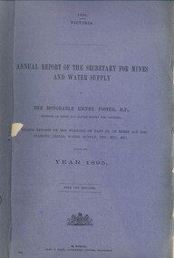
Book - ANNUAL REPORT OF THE SECRETARY FOR MINES AND WATER SUPPLY, c1896
Annual Report For The Secretary For Mines And Water Supply, Victoria 1895. Publisher: Government Printer, Melbourne. 86 pages. Plans & drawings.victoria, victorian mining report, mining machinery mine safety mining statistics -
Bendigo Historical Society Inc.
Map - LOCKWOOD, November 25th 1855
Map: Garden Allotments within the Town Reserve of Lockwood on the Bullock Creek. Parish plan (number 273 in map cupboard 1)map, bendigo, parish plan, lockwood, garden allotments, bullock creek -
Clunes Museum
Drawing - PLAN DRAWING
FACTORY COMPLEX DEMOLISHED IN APPROX. 1968PLAN DRAWN AND PAINTED WITH WATERCOLOURS OF EBERHARD & CO. CLUNES & TALBOT CORDIAL FACTORY IN FRASER STREET CLUNES. SKETCHED FROM THE MEMORY OF:-eberhard & co. cordial, clunes & talbot, plans of former buildings -
Tatura Irrigation & Wartime Camps Museum
Book, Australian War Memorial, Canberra, 1941
First Edition, Australian War Memorial Canberra displays history of all who fought in the Wars. Names listed of all who died.Red and beige cover. Brown linen binding, exterior sketch of forecourt and dome n front and back. Includes floor planww1 and ww2, military, australian deaths in ww1 -
Victorian Aboriginal Corporation for Languages
Book, J Hobson, Re-awakening languages : theory and practice in the revitalisation of Australia's Indigenous Languages, 2010
Language policy and planning, Language in communities, Language centres and programs, Language in education, Literacy and oracy, Language and technology, Language documentationScreen shots, b&w photographs, b&w diagramslinguistics, sociolinguistics, kaurna, wiradjuri, ngapartji ngapartji, dharug, dhurga, language and technology -
 Robin Boyd Foundation
Slide, Robin Boyd
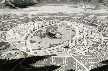
Colour slide in a mount. Magazine image of 'Horizon City' plan for El Paso (1959), Texas, USA. (Architect: Lucio Costa.)Made in Australia / Encircled 49 (Handwritten) / 1.5m (Handwritten) / city 'Horizon city' (Handwritten) / 167 mile (Handwritten) / lake park (Handwritten) / Texas new El Paso (Handwritten) / Brazchari (?): Lucio Costa (Handwritten) / 13 (Handwritten)the puzzle of architecture, slide -
University of Melbourne, Burnley Campus Archives
Document, The Orchard at Burnley Gardens, 1951-1960
Notes re history of the orchard; plans of various fruit blocks, 1-page of notes "The Orchard at Burnley Garden" in Box 74.orchards, fruit blocks, burnley -
Whitehorse Historical Society Inc.
Article, Plans for growth, 1993
State government plans to set population targets in all municipalities could force Nunawading to increase its population by at least 6000.State government plans to set population targets in all municipalities could force Nunawading to increase its population by at least 6000.State government plans to set population targets in all municipalities could force Nunawading to increase its population by at least 6000.city of nunawading, glickman, ray, demography