Showing 10933 items
matching land
-
 Bendigo Historical Society Inc.
Document - H.A. & S.R. WILKINSON COLLECTION: CONTRACT OF SALE
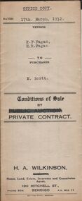
Conditions of sale by private contract dated 17th March, 1932 between E.F. Fagan & H.R. Fagan (sellers) and M. Scott (buyer) for land situate 69 Neale Street Bendigo being Crown allotment 102, section H described in certificate of title volume 4451 folio 890162, together with 5-roomed weatherboard and brick dwelling and all sundry. Price 300 pounds. Vendor copy.organization, business, h.a. & s.r wilkinson real estate -
 Bendigo Historical Society Inc.
Document - H.A. & S.R. WILKINSON COLLECTION: CONTRACT OF SALE
Conditions of sale by private contract dated 17th March, 1932 between E.F. Fagan & H.R. Fagan (sellers) and M. Scott (buyer) for land situate 69 Neale Street Bendigo being Crown allotment 102, section H described in certificate of title volume 4451 folio 890162, together with 5-roomed weatherboard and brick dwelling and all sundry. Price 300 pounds. Office copy.organization, business, h.a. & s.r wilkinson real estate -
 Bendigo Historical Society Inc.
Document - H.A. & S.R. WILKINSON COLLECTION: CONTRACT OF SALE
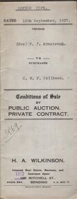
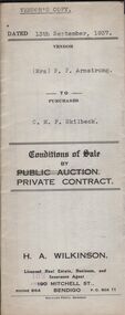
Conditions of sale by private contract dated 13th September, 1937 between Mrs. F.P. Armstrong (seller) and C.M.F. Skilbeck (buyer) for land situate 106 Thistle Street, Bendigo being part of Crown allotment 14 section 16B described in certificate of title volume 4386 folio 877150, together with 4-roomed weatherboard dwelling and all sundry. Price 300 pounds. Office copy.organization, business, h.a. & s.r wilkinson real estate -
 Bendigo Historical Society Inc.
Document - H.A. & S.R. WILKINSON COLLECTION: CONTRACT OF SALE
Conditions of sale by private contract dated 13th September, 1937 between Mrs. F.P. Armstrong (seller) and C.M.F. Skilbeck (buyer) for land situate 106 Thistle Street, Bendigo being part of Crown allotment 14 section 16B described in certificate of title volume 4386 folio 877150, together with 4-roomed weatherboard dwelling and all sundry. Price 300 pounds. Vendor's copy.organization, business, h.a. & s.r wilkinson real estate -
 Bendigo Historical Society Inc.
Document - H.A. & S.R. WILKINSON COLLECTION: CONTRACT OF SALE
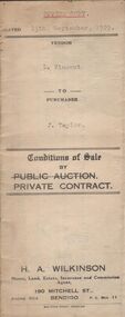
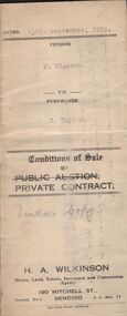
Conditions of sale by private contract dated 13th September, 1929 between F. Vincent (seller) and J. Taylor (buyer) for land situate Upper Road, California Gully being Crown allotment 292 section M at California Gully, Borough of Eaglehawk described in certificate of title volume 2959 folio 591717, together with 6-roomed weatherboard dwelling and all sundry. Price 210 pounds.organization, business, h.a. & s.r wilkinson real estate -
 Bendigo Historical Society Inc.
Document - H.A. & S.R. WILKINSON COLLECTION: CONTRACT OF SALE
Conditions of sale by private contract dated 13th September, 1929 between F. Vincent (seller) and J. Taylor (buyer) for land situate Upper Road, California Gully being Crown allotment 292 section M at California Gully, Borough of Eaglehawk described in certificate of title volume 2959 folio 591717, together with 6-roomed weatherboard dwelling and all sundry. Price 210 pounds.organization, business, h.a. & s.r wilkinson real estate -
 Bendigo Historical Society Inc.
Document - H.A. & S.R. WILKINSON COLLECTION: CONDITION OF SALE
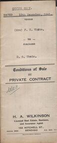
Conditions of sale by private contract dated 18th December, 1941 between Mrs. F.E. White (seller) and D.G. Thain (buyer) for land situate corner Echuca and Rodney Streets, Bendigo, at present unoccupied, being part of Crown allotment 17 section 100C described in certificate of title volume 6137 folio 1227385, together with 5-roomed weatherboard dwelling and all sundry. Price 290 pounds.organization, business, h.a. & s.r wilkinson real estate -
 Bendigo Historical Society Inc.
Document - H.A.& S.R. WILKINSON COLLECTION: CONDITION OF SALE
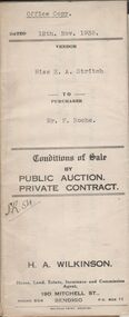
Conditions of sale by private contract dated 12th November 1935 between Miss E.A. Stritch (seller) and Mr. F. Roche (buyer) for land situate No. 81 King Street, Bendigo being part of Crown allotment 15A section 52C described in certificate of title volume 1604 folio 320693, together with 5-roomed weatherboard and brick dwelling and all sundry. Price 375 pounds.organization, business, h.a. & s.r wilkinson real estate -
 Bendigo Historical Society Inc.
Document - H.A.& S.R. WILKINSON COLLECTION: CONDITION OF SALE
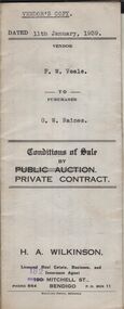
Conditions of sale by private contract dated 11th January, 1939 between F.W. Veale (seller) and G.W. Raines (buyer) for land situate No. 11 Alley Street, Bendigo being part of Crown allotment 70 section A at Ironbark Gully described in deed of conveyance, registered memorial 836 book 532, together with 4-roomed weatherboard dwelling and all sundry. Price 250 pounds - Vendor's copy.organization, business, h.a. & s.r wilkinson real estate -
 Bendigo Historical Society Inc.
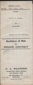
Document - H.A. & S.R. WILKINSON COLLECTION: CONDITION OF SALE
Conditions of sale by private contract dated 24th July, 1941 between Mrs. E. Brown (seller) and Miss A.G. Ridding (buyer) for land situate No.73 Honeysuckle Street, Bendigo being part of Crown allotment 6 section 14B described in Crown grant volume 1056 folio 211103, together with 4-roomed weatherboard and rough cast dwelling and all sundry. Price 615 pounds.organization, business, h.a. & s.r wilkinson real estate -
 Bendigo Historical Society Inc.
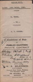
Document - H.A. & S.R. WILKINSON COLLECTION: CONDITION OF SALE
Conditions of sale by private contract issued by H.A. Wilkinson and dated 15th March, 1949 between W. Young (seller) and C.P. Rogers (buyer) for land situate in Brown Street Eaglehawk having a frontage of 129 links to Brown Street , by a depth of 192 links and being described in right of occupy residence area No. 5412, together with 5-roomed weatherboard dwelling and all sundry. Price 480 pounds.organization, business, h.a. & s.r wilkinson real estate -
 Bendigo Historical Society Inc.
Document - NORMAN OLIVER COLLECTION: SPEECH NOTES 1949-1971
The Norman Oliver collection. Norman Oliver was three times Mayor of Bendigo - 1950-51, 1964-65, 1970-71. Fourteen pages of typed notes, untitled and undated. Additions and corrections in blue ink. Introduction suggests that this is first report and the beginning of his 3BO 'The Mayor Speaks'. Topics include : sewerage development, land reclamation, garbage collection, soldier employment preference, finance, and social events.bendigo, council, speech notes, norman joseph oliver , councillor norman oliver. mayor of bendigo. 3bo 'the mayor speaks'. -
 Port Melbourne Historical & Preservation Society
Document - Report, Ewan Ogilvy's Bayside Papers, Bayside EES Inquiry, Ewan Ogilvy's Bayside Papers, Box One, 1988
Ewan Ogilvy, former Melbourne Councillor and also of Community Services Victoria, Inner Urban Ministerial Advisory Committee and Uniting Church's Centre for Urban Research and Action (CURA), was instrumental in social justice approaches to town planning. He and CURA's Social Justice and the City Project funded Port Melbourne community groups protesting against the SCDC development in 1987. His files were presented to the Society in May 2001 on his preparation for leaving Victoria.From Ewan Ogilvy's chronologically organised 'Bayside Papers' relating to the proposed development of Port Melbourne industrial land in the late 1980s: EES Inquiry report to the Minister for Planning and Environment 7 April 1988, included in bound black file. appendix 1 Terms of Reference Kennan to Lethlean 1.09.1987; Appendix 2 contains names of 1003 persons and organisations submitting to enquiry, and analysis of those submissionsAll items signed 'Ewan Ogilvy'town planning, town planning - proposals shelved - bayside, public action campaigns, environmental issues, public housing, ewan ogilvy, centre for urban research and action, sandridge city development co pty ltd, scdc, linton r lethlean, judy arndt, francis b barnes -
 Bendigo Historical Society Inc.
Document - LANDS OFFICE: APPLICATIONS FOR LEASES RECEIVED AT BENDIGO DISTRICT LAND OFFICE, 2/3/1967 - 29/11/1982
Document: hard cover journal with green cover and buff spine and corners. Contains listing of applications received for leases ( type not specified ) in Bendigo area. LH page: number of application, date of receipt, name, postal address, parish. Rh page: allotment, section, area, recommendation and disposal. On spine in red rectangle ' Land Act applications received' Written on front cover in black ink: application register.Lands Office Bendigocottage, miners -
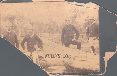 Bendigo Historical Society Inc.
Photograph - HARRY BIGGS COLLECTION: KELLY'S LOG
Photograph of four policemen leaning against a fallen tree with the words Kelly's log painted on the tree. One of the men is holding a gun and another has a sword at his side. There is a post and Rail fence visible in the background with bush land behind. A deputation from the Bendigo Historical Society presented a copy of this photo to the Beechworth Museum. They did not have it in their colllection. Reference: Newspaper article, Bendigo Advertiser, dated 26.3.1969person, group, policemen, kelly's log -
 Bendigo Historical Society Inc.
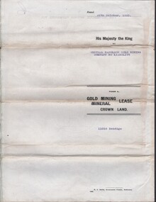
Document - MCCOLL, RANKIN AND STANISTREET COLLECTION COLLECTION: CENTRAL NAPOLEON GOLD MINING CO. N.L, 30th October 1939
Document: Gold Mining Lease crown Land No 11016 Bendigo, Entered in the register book Vol. 324 fol. 35754, Embossed seals of Central Napoleon Gold Mining Co N.L. and Kin g George VI, Map: Mining District of Bendigo, County of Bendigo, Parish of Sandhurst, located at Harvey & Inglis Streets, During the reign of King George VI (document orignally had Edward VIII).organization, business, industry - mining, mccoll rankin & stanistreet, mining, gold mining, central napoleon -
Clunes Museum
Document - APPLICATION FOR MINING RIGHTS
.1 NOTICE TO OWNER OR OCCUPIER UNDER THE MINES ACT. HENRY PEACOCK APPLIED TO MINING RIGHTS ON LAND AT LORD CLYDE OWNED BY LACHLAN MCLENNAN.DATED 1897 .2 COVERING LETTER FROM H, PEACOCK TO L MCLENNAN DATED 21 AUGUST 1897 .3 AGREEMENT UNDER THE MINES ACT 1890 DATED 16 AUGUST 1897 (2 COPIES) BETWEEN H PEACOCK AND L MCLENNANhenry peacock, lachlan mclennan -
 Whitehorse Historical Society Inc.
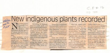
Article, New indigenous plants recorded, 23/09/1992 12:00:00 AM
An article discussing the outcome of a project to list, photograph and identify indigenous plants growing on public land in the City of Nunawading. The project has discovered 28 new species. Council staff have collected seed and propagated more than 7000 plants helping to reinstate a number of endangered species. The project has extended to include non-indigenous and exotic plants. Plaques are being created identifying trees.native plants, trees, prestegar, geoff, tree register project, city of nunawading -
 Bendigo Historical Society Inc.
Document - NEVILLE KING COLLECTION: OCCUPATION CERTIFICATE HOMESTEAD FARM NO. 15/939 IN THE NAME OF DAVID WILLIAMS AT A COST OF ONE POUND, DATED 25 SEPTEMBER 1897, 1897
Under the Western Australia 'the Homestead act 1893' an Occupation Certificate, Homestead Farm No. 15/939 for David Williams of Bendigo for 160 acres (near Woolkabunning near Bunbury WA); at a cost of one pound. Signed by order of the Commissioner of Crown Lands. Dated 25 September 1897. The land is marked and distinguished in the maps and books of the Department of Lands and Surveys of the said (WA) Colony as Williams Location No. 702. -
 Bendigo Historical Society Inc.
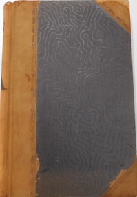
Document - LANDS OFFICE - CROWN LANDS SURVEYED AND SOLD SANDHURST - 1857 - 1879, 1857 - 1879
Journal: black hard cover with buff spine and corners. Contains details of crown land surveyed and sold, district of Sandhurst. Double pages numbered on top right, page columns - parish, town lands, particulars, survey fees, date of survey, date of sale, auction, selection price per acre, total amount, purchaser. No index. On spine '08' 'Bendigo A' 26th June 1857 to 1879 (?)Lands Officeplace, land sales, lands office, crown land, land surveys, bendigo, sandhurst -
University of Melbourne, Burnley Campus Archives
Newspaper - Newspaper Cutting, The Age, The University of Melbourne, 2004-2006
Collection of 3 newspaper articles. (1) "Private Income, public tension." Review of book, "Off Course: From Public Place to Marketplace at Melbourne University" by John Cain and John Hewitt, R.J.W. Sellick Reviewer in "The Age" March 13, 2004. (2) "Classes Move" in "The Leader" March 2006. (3) "Land and Food Resources to refocus on higher education" in "Melbourne University Magazine" August 2005 p5.john cain, john hewitt, r.j.w. sellick, off course: from public place to market place at melbourne university, land and food resources, higher education -
Bendigo Historical Society Inc.
Book - Man of Stature - J.A.Panton
Joseph Anderson Panton migrated to Sydney in 1851 and went to the Port Phillip District. After farming briefly at Mangalore, he tried for gold without success at Mount Alexander. In 1852 Panton was appointed assistant commissioner at Kangaroo Gully, near Bendigo, senior assistant commissioner at Bendigo in 1853 and senior commissioner in 1854. Source: Australian Dictionary of Biography. https://adb.anu.edu.au/biography/panton-joseph-anderson-4362 268-page soft cover book titled 'Man of Stature' J.A.Panton Law, land & service 1831-1913 A biography by Terry Davidson. Light brown covers with a B&W sketch on front cover of J A Panton standing next to desk . Illustrated with colour, B&W photos, sketches and maps. Printed in Melbourne, Australia by Caidex Communications, 2024. ISBN: 978-0-6458646-8-7j a panton, law, goldfields, joseph panton, gold commissioner -
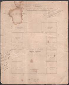 Bendigo Historical Society Inc.
Document - BEEBE, BAPTIST CHURCH DRAWING
Parchment paper architect drawing by William Beebe. Printed heading, 'Proposed Sunday School, Baptist Church', dated 21/9/ 05. Scale 8 feet to Inch. Eight rooms surrounding 30 feet x 50 feet main hall lighted by clearstory. Handwritten cost estimated if weatherboard £850, brick £1040, fencing not included. Land & house 72-foot frontage. Unknown donorbendigo, churches, baptist, beebe -
 Glenelg Shire Council Cultural Collection
Painting, Sunset, Blairs Creek 1893, 1893
Roundel painting in circular frame. Scene depicts a lagoon edged with grass and low bushes in foreground and trees in background. Two black swans swim in foreground and a boat with a mast and rigging is anchored near land and a tree at centre right of image. Top half of painting is a sunset with clouds in pink, red, white, yellow, indigo, russet. These colours are generally reflected in foreground water. Framed in round wooden frame.Front: (no inscriptions) Back: "Sunset" Blair's Creek, Portland. Jan. 7th 1893 (centre) (black ink). 90 (ink on varnish) (centre left). 1996 (pencil) (upper left). -
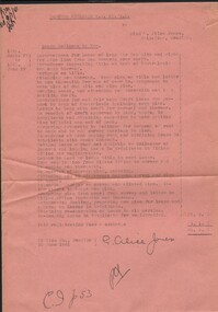 Bendigo Historical Society Inc.
Document - MISS G ALICE JONES COLLECTION: ACCOUNT
Deborah Extended G. M. Co. N.L. to Miss Alice Jones. Pink paper dated 27 1940 to June 27 1941 and 30 June 1941. Re Lease McKinnon to you. Instructions for Lease of land for dam site and right for pipe line from dam towards your shaft. Total cost £6.6.7. "R701 del 9/7/4" written in top left corner.the miss g.alice jones collection - account, deborah extended g. m. co n.l., mckinnon, bank of australasia, mr jorgensen -
 Bendigo Historical Society Inc.
Document - LANDS OFFICE BENDIGO LITHO REGISTER, Jan. 1952 - Feb. 1978
Document: hard cover journal, black cover with buff spine and corners. Contains register of land maps sold by Bendigo Lands Office. Handwritten entries on ruled pages. LH page: date, number received, name of plan, litho number, price, amount, date, name of plan, price, number sold, amount, number used in office, amount. Rh page: repeat of LH page.Lands Office Bendigobendigo, lands office, litho register -
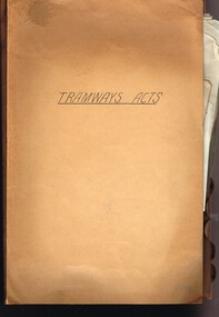 Melbourne Tram Museum
Document - Personal Papers, Melbourne & Metropolitan Tramways Board (MMTB), "Tramway Acts", 1945 to 1954
Brown coloured file folder marked "Tramway Acts" containing hand written and type written notes on the various MMTB Acts, generally c1945 to 1948 - multiple copies of the same document involving Land Acquisition, Appeals Board, powers under the Act, WW2 National Security Act (under which the Essendon Airport and Maribyrnong or Munitions tramways were built) repeal, buses, and orders in council.trams, tramways, mmtb, acts of parliament, world war 2, appeals, unions, essendon airport, west maribyrnong, munitions factory -
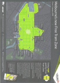 Melbourne Tram Museum
Map, Public Transport Victoria (PTV), "Melbourne's new Free Tram Zone", 2015
Printed A4 sheet - single sided off white sheet titled ""Melbourne's Free Tram Zone Map"., details the extent of the free tram zone or showing the tram lines that the free travel is allowed, locations, land marks, contact numbers and has the PTV logo in the top right hand corner and the Myki locos along with Yarra Trams and contact details for information. Dated 1/1/2015.trams, tramways, yarra trams, ptv, maps, free tram, melbourne -
 Ringwood and District Historical Society
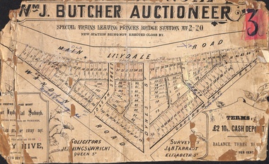
Poster - Land Sale, Wm J. Butcher, Auctioneer - Albert Park Estate, Ringwood - c.1890
Central section of land sale subdivision advertisement glued to heavy cardboard backing. Photocopied SLV image of original advertisement shows map of 117 allotments for sale in Main Lilydale Road (later Old Lilydale Road), Wandin Road (later Mount Dandenong Road), Joseph Street, Dynes Street, Albert Street (later Wyrunga Street) and Government Road (later Carcoola Road), Ringwood East.Solicitors - Jenningw & Wright, Queen Street. Surveyors - J.&H. Tarrant, Elizabeth Street. Terms £2 10s cash deposit, balance three years at six per cent. -
Clunes Museum
Document - NEWSPAPER, CLUNES & TALBOT GUARDIAN, CLUNES GUARDIAN AND GAZETTE, 14/04/1939
SPECIAL EDITION .1 NEWSPAPER CLUNES GUARDIAN & GAZETTE, 14 APRIL, 1939. CLUNES CELEBRATES ITS 100TH BIRTHDAY. LISTS BUSINESSES 1863, LAND SETTLERS, HISTORY, CHURCHES, ITEMS FROM EARLY NEWSPAPERS. .2 PHOTOCOPY OF 1ST PAGE .3 NEWSPAPER CLUNES GUARDIAN & GAZETTE 14 APRIL, 1939. CENTENARY CELEBRATIONS OFFICIALLY OPENED BY SIR HARRY CHAUVEL IN THE PRESENCE OF 4000 PEOPLE.W. COOK WRITTEN IN PENCIL ON TOP R.H. CORNER1939, clunes 100th birthday, businesses 1863, clunes guardian & gazette, early land settlers, sir harry chauvel