Showing 11115 items
matching planning
-
 Bendigo Historical Society Inc.
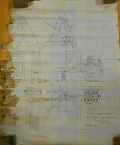
Document - MARKS COLLECTION: PLAN LANSELL'S COMET PROPRIETARY MINE BENDIGO
Plan (engineering drawings) for construction of crushing and elevating plant at Lansell's Comet Proprietary Mine, Bendigo. Drawings show detail for crusher and elevator, brick foundations. Plan is annotated with e.g. number of revolutions of jaw crusher. On bottom written in black pen: arrangement crushing and elevation plant for Lansell's Proprietary Comet Mine Bendigo, Hargreaves & Daggar, Consulting Engineers, Victoria Chambers.mining, crushing & milling, lansell's comet mine -
 Kew Historical Society Inc
Plan, Studley Park Estate, 1910
Prue Sanderson, in her groundbreaking ‘City of Kew Urban Conservation Study : Volume 2 - Development History’ (1988), summarised the periods of urban development and subdivisions of land in Kew. The periods that she identified included 1845-1880, 1880-1893, 1893-1921, 1921-1933, 1933-1943, and Post-War Development. These periods were selected as they represented periods of rapid growth or decline in urban development. An obvious starting point for Sanderson’s groupings involved population growth and the associated economic cycles. These cycles also highlighted urban expansion onto land that was predominantly rural, although in other cases it represented the decline and breakup of large estates. A number of the plans in the Kew Historical Society’s collection can also be found in other collections, such as those of the State Library of Victoria and the Boroondara Library Service. A number are however unique to the collection.The Kew Historical Society collection includes almost 100 subdivision plans pertaining to suburbs of the City of Melbourne. Most of these are of Kew, Kew East or Studley Park, although a smaller number are plans of Camberwell, Deepdene, Balwyn and Hawthorn. It is believed that the majority of the plans were gifted to the Society by persons connected with the real estate firm - J. R. Mathers and McMillan, 136 Cotham Road, Kew. The Plans in the collection are rarely in pristine form, being working plans on which the agent would write notes and record lots sold and the prices of these. The subdivision plans are historically significant examples of the growth of urban Melbourne from the beginning of the 20th Century up until the 1980s. A number of the plans are double-sided and often include a photograph on the reverse. A number of the latter are by noted photographers such as J.E. Barnes.Coloured lithograph of a subdivision plan of the Studley Park Estate, bordered by Yarra, Willsmere Road and the Outer Circle Railway line. The estate was listed in 1910 and was the subject of a planning dispute between the developer and the Town of Kew in relation to flood levels and the suitability of the land for housing. In many cases the names of streets were subsequently changed. The layout was also affected by the creation of the Eastern Freeway. A newspaper report of the day described the subdivision as a: "GOLDEN OPPORTUNITY. We are pleased to submit for PRIVATE SALE that magnificent ESTATE, situated only 4 1/2 miles from the Melbourne General Post Office, STUDLEY PARK ESTATE. KF/NV. Doubtless the CHEAPEST LAND EVER OFFERED having extensive frontages to the prettiest spot on the River Yarra and the National Park, commanding lovely river and landscape views, and acknowledged to be the finest land available so close to the city. The PRICES ARE EXTREMELY MODERATE; The TERMS ARE SIMPLY MARVELLOUS. NO DEPOSIT. NO DEPOSIT. NO DEPOSIT. Allotments and prices to suit everyone."subdivision plans - kew, studley park estate -
 Phillip Island and District Historical Society Inc.
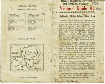
Booklet, Authentic Phillip Island Road Map, Pre 1960
Tourist brochure printed by the Phillip Island Printers pre 1960HistoricalSmall cream coloured brochure with details of accommodation, transport and animals. Inside is a map of the Island with numbered points of interest. There is also a plan of Cowes and drawings of animals.Visitors' Guide 6d Authentic Phillip Island Road Maptourist brochure, road map -
 Ringwood and District Historical Society
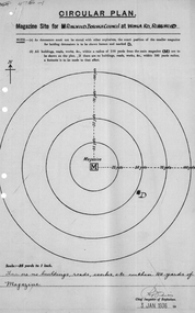
Plan of magazine site, Mines Dept, Explosives Magazine Licence and Maps, Wonga Rd Ringwood. 1940, 1936, 1938-1940
Plans for the magazine site in Ringwood, located at Wonga Road, Ringwood. Magazine licence 2 pages. Area map showing Warrandyte, Ringwood and Deep Creek. -
 Ringwood and District Historical Society
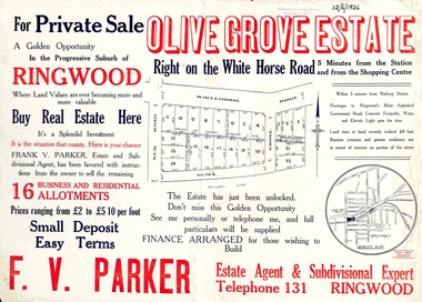
Flyer, Land Sale Advertisement, Olive Grove Estate, Ringwood, Vic. - 1926
Further development of 9 shop sites took place along Whitehorse Road (later street numbers 58 to 64 Whitehorse Road) between New Street and Olive Grove around 1950 - See Victorian Collections reference 5227.Single sided page with red and blue print advertising Olive Grove Estate business and residential allotments, including subdivision plan and summary of local services.Subdivision includes Whitehorse Road, New Street, and Olive Grove. Agent - F.V. Parker, Telephone 131, Ringwood. -
 Kiewa Valley Historical Society
Paper Sheet - Shire of Bright Plans
Oblong sheet of paper - bright yellow (or orange). Black typed writing and subdivision maps of the Kiewa Valley Planning Scheme in the Shire of Bright. Circa 1980s2 pages of maps and scriptshire of bright, maps, kiewa valley -
 Bendigo Military Museum
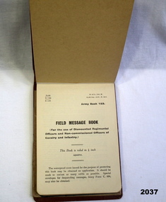
Accessory - NOTEBOOK, Government, c.1939-45
Benjamin Thomas Roy Chadd No's 10594, VX20311, 1st, 1st and 2nd AIF. Refer 2039 for service history also 2034P. Cotton covered brown cardboard Army book No 153. Contains numerous pencil entries of an officers orders & plans during Middle East campaigns WWII.Inside cover has signature of BTR Chadddocuments - notebooks, military history-army -
 Glenelg Shire Council Cultural Collection
Plan - Plan - subdivision at Cape Bridgewater, 02/04/1992
Black and white photocopy of an old plan of a subdivision at Cape Bridgewater. In two halves, not joined together. Black texta numbers on some of the lots 1 - 28town planning, residential, cape bridgewater -
Glenelg Shire Council Cultural Collection
Plan - Original boat line plans of army diesel tug boat, 'Vigorous' (later renamed 'Emily S'), 10/07/1959
Eden Killer Whale MuseumOriginal boat line plans of army diesel tug 'Vigorous' later owned by Geoff Collett of Eden and later renamed 'Emily S' by Tony Santic. -
 Greensborough Historical Society
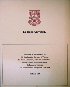
Program, La Trobe University: Installation of Chancellor and opening of the University 1967, 08/03/1967
Installation of Chancellor Sir Archibald Glenn at La Trobe University by Sir Rohan Delacombe, Governor of Victoria. Official opening of La Trobe University in Bundoora on 8th March 1967 by Premier Sir Henry Bolte. Contains background on the development of the university.Celebration of the establishment of the Third University of Victoria. Named after after Charles Joseph La Trobe, Victorias first Lieutenant Governor. It will grow to serve Victoria's North Western Community. The Setting is River Red Gums and grass lands which will be be maintained throughout.Manila coloured card folder with red coloured coat of arms of La Trobe University on cover. Development Plan of university on back cover. (3 copies)la trobe university, bundoora, archibald glenn. -
 Kiewa Valley Historical Society
Maps - Bogong High Plains & Mt Beauty Township
The SECV continually updated their mapsDuring the development of the KHES the SECV had to continually update their mapsBoth Foolscap 1. Titled: High Plains Access Tracks & Roads 2. Mt Beauty Street Plan by SECV with Section Nos. and house numbersBoth have sticky tape marks on their back.khes maps -
 Eltham District Historical Society Inc
Book, Conservation Management Plan - Eltham Justice Precinct (January 2006) prepared for Nillumbik Shire
Guidance on the heritage issues in the management of the court house and former police buildings of the early justice precinct at Eltham.68 p, 30 cm. Also draft copy - Conservation Management Plan (draft) for Justice Precinct Eltham (July 2005) prepared for Nillumbik Shire 2006 This copy is the property of the Eltham District Historical Society Inc.eltham justice precinct, justice precinct eltham -
 Ringwood and District Historical Society
Plan, Ringwood Station Estate, Subdivision, Ringwood, Victoria - circa 1925
ID 5224 note: Further information relating to squares marked H, F, G, J, and K included in ID 5225 - Ringwood Shop and Dwelling Estate.Hand drawn plan of Ringwood Station Estate showing allotments for sale, with two typed pages attached showing land title information and sale prices.Drawn by Edyth Greenwood, phone 988 Central. Subdivision includes Station Street, Pitt Street, Bedford Road, Wantirna Road, James Street, William Street (later Kendall Street), Greenwood Avenue, Ellison Street, and Haig Street. Circles denote blocks for sale. Squares denote house properties for sale. Other features marked include location of businesses along Main Street (Maroondah Highway), cool store, railway station, shop and police station on Bedford Road, church on Station Street, site of schoolmaster's residence and State School, and location of proposed public baths. Ryner & Langford, Solicitors -
 Federation University Historical Collection
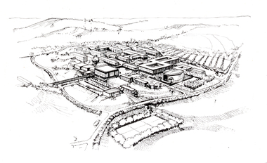
Photograph - Black and White, Aerial Depiction of a Plan for the Mount Helen Campus, c1969, c1969
The new campus at Mount Helen was part of the Ballarat School of Mines, and was known as Ballarat Institute of Advanced Education. The drawing was prepared in the early stages of the Mount Helen campus development, while Stage I buildings ('E', 'F', 'G') were constructed. the Union Building (now Albert Coates Centre), Library, 'S' Building and student accommodation were in the design stage. The original drawing was photographed by using special equipment in the offices of Department of Crown Lands, treasury Place, Melbourne.Artwork showing an aerial view of a planned academic campus at Mount Helen. .1) Black and white print of a line drawing. 2) Transparency of above imagefederation university, federation university australia, feduni, university of ballarat, ballarat institute of advanced education, harrison, vernon, campus, mount helen -
 Federation University Historical Collection
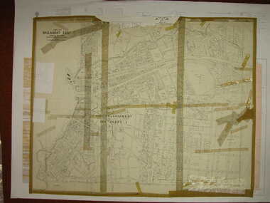
Plan, Ballarat East, 1916, 24/05/1916
Plan of streets and allotments in Ballarat East. Includes: Bakery Hill, Canadian Station, Eureka Cemetery, Orphan Asylum, Eureka Gardens and Reserve, Gun Clubballarat east, bakery hill, eureka stockade site, eureka gardens, ballarat orphanage -
Federation University Historical Collection
Book - Booklet, University of Ballarat Reconciliation Action Plan, 2009-2010, 2009
Soft covered booklet documenting the University of Ballarat Reconciliation Action Plan. Photographs include Christine Ward, Ben Atkinson, Katrina Beer, Shirley Morganreconciliation action plan, aborigines, aboriginal education unit, ben atkinson, katrina beer, shirley morgan, christine ward, reconciliation, university of ballarat, aboriginal education centre -
 Bendigo Historical Society Inc.
Book - EAGLEHAWK CEMETERY PLANS OLD MONUMENTAL
Eaglehawk Cemetery Plans Old Monumental, researched by Annette O'Donohue and Bev Hanson contains 117 pages, printed by La Trobe University Bendigo printery.Annette O'Donohue/Bev Hansonbook, bendigo, eaglehawk, eaglehawk-cemetery-burials -
 Bendigo Historical Society Inc.
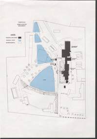
Document - NORM HARRIS COLLECTION: PLAN OF 'FORTUNA 'ARMY SURVEY REGIMENT
Norm Harris Collection Plan of 'Fortuna 'Army Survey Regiment showing original buildings , original lakes and existing details together with Roman bath and a tunnel.plan, bendigo -
Port Melbourne Historical & Preservation Society
Plan - Pickles Street, Town of Emerald Hill and Borough of Sandridge, Sep 1881
Town of Emerald Hill and Borough of Sandridge plan for Pickles Street, including transverse and longitudinal sections - Spring to Graham. NB "bridge" near Liardet Street.Signed by Charles Clayengineering - roads streets lanes and footpaths, charles clay -
Port Melbourne Historical & Preservation Society
Document - CD-ROM, Best Hooper re Port Phillip Planning Scheme Amendment C104, 14 Nov 2013
CD/DVD of documents for Best Hooper relating to Port Phillip Planning Scheme Amendment C104. White CD/DVD in dark blue patterned coverbuilt environment, local government - city of port phillip, town planning -
Port Melbourne Historical & Preservation Society
Plan - Construction of Liardet Street, Port Melbourne, John Foly?, Draughtsperson, 1860 - 1884
Working drawing: longitudinal section, ground plan, transverse section for the construction of Liardet Street between Nott Street and Railway Place. Between 1860 and 1884."Borough of Sandridge":"Chas Clay":"John Foly"engineering - roads streets lanes and footpaths, engineering department - borough of sandridge, charles clay, john foly, liardet street -
Port Melbourne Historical & Preservation Society
Plan - Danks Street from Pickles Street to Esplanade East, Town of Port Melbourne, 28 Feb 1893
Plan of Danks Street, from Pickles Street to Esplanade East and bearing the seal of the Borough of Port Melbourne as well as agreement to contract to carry out works.A.V. Heath (Town Surveyor):Michael Minahan (?) (Contractor):J.J. Bartlett (Mayor):Prohasky (Councillor):E.C. Crockford (Town Clerk):W. Harrison (Witness)engineering - roads streets lanes and footpaths, engineering - fences, local government - borough of port melbourne, arthur victor heath, james john bartlett, william henry prohasky, edward c crockford, town clerks, w harrison, michael minahan -
Port Melbourne Historical & Preservation Society
Document - Reports, Deacons, Graham and James for Becton and others to panel reviewing C5 amendment to Port Phillip Planning Scheme, Graham Deacons et al, 1999
The C5 Amendment aimed to create a framework for built form and development controls in the Port Melbourne Mixed Use Area undergoing conversion to residential development. Heritage overlays to protect heritage areas were also under review.Developer submissions to an independent Panel reviewing the C5 amendment to the Port Phillip Planning Scheme, 1999 Report from Deacons, Graham and James for Becton and otherstown planning, built environment - civic, heritage, becton, fox hay timber and hardware pty ltd -
Port Melbourne Historical & Preservation Society
Document - Submission, C5 amendment to the Port Phillip Scheme, 1999
Submission [2 copies] by Greg Hansen for the Port Melbourne Historical and Preservation Society, to the Panel reviewing the C5 amendment to the Port Phillip Planning Scheme, 1999town planning, built environment, greg hansen -
Port Melbourne Historical & Preservation Society
Plan - Coal tramway, Town Pier to Gas Works via Esplanade West, 1880s
From set of three photocopies of two plans of coal tramway, Town Pier to Gas Works via Esplanade West: Reduced size version of 656.01transport - tramways, utilities - gas, sandridge lagoon, industry - manufacturing, piers and wharves - town pier, metropolitan gas company, australasia sugar refining company, robert harper & co ltd -
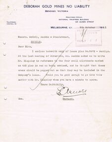 Bendigo Historical Society Inc.
Document - MCCOLL, RANKIN AND STANISTREET COLLECTION: DEBORAH GOLD MINE NL - LEASE DOCUMENTS, 1935, 1941
Document: McColl, Rankin and Stanistreet: lease documents. 12 pages of lease details, with attached map plan on no 9672 Bendigo. ( Abel and Eve Street marked )organization, mining, deborah gold mines nl, mccoll, rankin and stanistreet: deborah gold mines nl, gold mining, lease -
Bendigo Historical Society Inc.
Map - MINING PLAN ,VICTORIA HILL AREA, No date visible
Map: Large scale plan of an area of the Goldfield, Northward from Barnard Street, covering the Victoria Hill area. Black printing on polycarbonate film. Transparent.map, bendigo, mining plan, mining, gold mines, victoria hill, lines of reef -
Clunes Museum
Document - BOOK, BACK TO CLUNES 1957-60
LOCAL HISTORYGREY CARDBOARD COVERED EXERCISE BOOK 'THE SHELL EX BOOK' CONTAINING MINUTES FROM PLANNING MEETINGS. DETAILS OF BALL TAKINGS, NEWSPAPER ARTICLE REQUESTBACK TO CLUNES COMMITTEE YEAR 1957local history, back to clunes 1957-60, minutes -
Tatura Irrigation & Wartime Camps Museum
Book, Warwick Finlay, The Doctor, The Captain, The Poet and Others, 2004
This book was printed to commemorate the 150th Anniversary of the survey, naming of the town and sale of land at Murchison.Black and white cover featuring the Goulburn River and portraits of Doctor McMillan, Captain John Murchison and Orion Horne over and early plan of Murchison Townshipmurchison -
 Robin Boyd Foundation
Slide, Robin Boyd
Colour slide in a mount. Image of the sketch plan of the Desbrowe Annear House (in Robin Boyd's handwriting), 36-38 The Eyrie, Eaglemont, Victoria, Australia (1903)Made in Australia / Encircled 37 (Handwritten) / Encircled A (Handwritten)slide, robin boyd