Showing 123779 items matching "main-road"
-
 Whitehorse Historical Society Inc.
Document - Correspondence, Burwood Road, 16/12/1937
Claim for reimbursement from Country Roads Board for amounts expended on Burwood Road by Shire of Blackburn and Mitchamshire of blackburn and mitcham, victoria. country roads board, burwood road, roads and streets -
 Whitehorse Historical Society Inc.
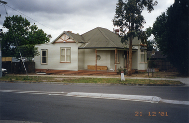
Photograph, Whitehorse Road, Mitcham No.427, 21/12/2001 12:00:00 AM
Coloured photograph of 427 Whitehorse Road, Mitcham showing Dunlavin Road side of house being renovated.whitehorse road, mitcham, no.427 -
 Whitehorse Historical Society Inc.
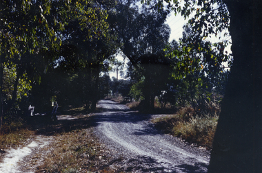
Photograph, Glenburnie Road, Vermont, 1967
Part of Tim Shambrook's Collection for 'This is Vermont'. Not used.Coloured photo of Glenburnie Road, Vermont, taken in 1967, showing dirt track before road was made.glenburnie road, vermont, shambrook, tim -
 Whitehorse Historical Society Inc.
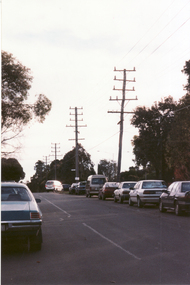
Photograph, Cnr. Cochrane & Whitehorse Road, 1/06/1999 12:00:00 AM
Coloured photo looking towards Mitcham Road from Corner Cochrane Street and Whitehorse Road, Mitcham.whitehorse road mitcham, cochrane street mitcham, overhead powerlines -
 Whitehorse Historical Society Inc.
Photograph, Canterbury Road Vermont
Coloured print of a 110 slide of the making of the dual highway of Canterbury Road Vermont, near Mitcham Road.canterbury road vermont, mitcham road, vermont, roads and streets -
 Whitehorse Historical Society Inc.
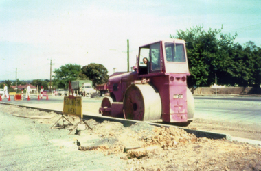
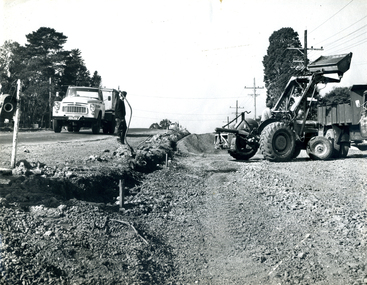
Photograph, Roadworks in Canterbury Road, Forest Hill
Black and white photo of Roadworks in Canterbury Road, Forest Hill. east of Springvale Road in conjunction with C.R.B.canterbury road, forest hill, victoria. country roads board -
 Whitehorse Historical Society Inc.
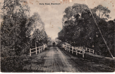
Postcard, Surry (Sic) Road, Blackburn
Black and white Postcard entitled Surry (sic) Road, Blackburn. Shows unmade road, bridge and jinker.surrey road, blackburn. -
 Whitehorse Historical Society Inc.
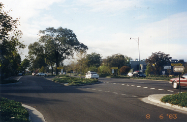
Photograph, Whitehorse Road, Mitcham
Coloured photo of Whitehorse Road looking east from the corner of Doncaster East Road. Taken 2003whitehorse road, mitcham -
 Coal Creek Community Park & Museum
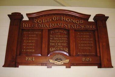
Honour Roll, Kilcunda Road School Honor Roll
This WWI Honor Roll was originally displayed in the Kilcunda Road State School (no.3337), which was located at the north east corner of the intersection of the Bena - Kongwak and Buchanans' Roads, Bena, Victoria, 3946. The school was located amongst the cypress trees at 645 Bena-Kongwak Road. The school was relocated in 2008 to the Coal Creek Community Park and Museum, 12 Silkstone Road, Korumburra, 3950 to become the Masonic Lodge building in the park display. On the west side of the intersection of the Bena - Kongwak and Buchanans' Roads is a brass plaque on a granite boulder with the following inscription TO COMMEMORATE THE DISTRICT OF KILCUNDA ROAD First Surveyed 1879. This is the site of the KILCUNDA ROAD UNITING CHURCH 1911 to 1966. Diagonally opposite at 645 Bena-Kongwak Road was the site of the KILCUNDA ROAD PRIMARY SCHOOL No: 3337, 1902 to 1975. Erected by The School Mother’s Club continuing as The Kilcunda Road Social Club 2008. One of the few remaining historic items from Kilcunda Road settlement.Honour roll of varnished wood, with three panels, an undulating shaped pediment, plain columns at sides, painted gold text and the Australian Imperial Forces insignia on base.Roll of Honor, Kilcunda Road State School. In Honor of Old Scholars of this school who served the Empire in the Great War, 1914-1919, Australian Imperial Force. (X) These made the supreme sacrifice. Sister J.E. Turner , E.N. Barge, E.F. Binding (X), E.H. Bunn, D. James (X), W.James, A. James (X), R. H. James, A.G. Rose (X), C.W. Stanlake, G. Wuchatsch, R. Wuchatsch, T.E. Young kilcunda road, honour roll, state school no.3337., wwi -
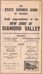 Greensborough Historical Society
Advertisement - Digital image, Diamond Valley News, State Savings Bank of Victoria, 1964, 29/09/1964
Advertisement for the State Savings Bank of Victoria, congratulating the Shire of Diamond Valley on behalf of its branches, 84 Main Street, Greensborough and Watsonia Road, Watsonia and agents, 1964Digital copy of newspaper advertisement.main street greensborough, state savings bank of victoria, watsonia road -
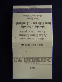 Greensborough Historical Society
Match Container - Digital Image, Da Roberto Restaurant matchbook, 1980s, 1980s
Digital image of Da Roberto Restaurant matchbook, circa 1980, used for advertising. Da Roberto was an Italian restaurant situated on the corner of Main Street and Para Road Greensborough.Part of a collection of miscellaneous historical images with a connection to the local area.Digital image of paper matchbook."Da Roberto Restaurant ..." da roberto restaurant -
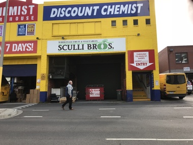 Greensborough Historical Society
Photograph - Digital Image, Sue Ballantyne, Sculli sign, rear Main Street 2018, 31/07/2018
This photograph shows the Sculli Bros sign at the rear of Chemist Warehouse in Main Street Greensborough. This building was formerly Sculli Bros fruit and vegetable shop.Digital copy of colour photographmain street greensborough, sculli family, sculli -
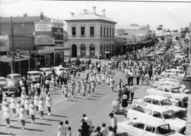 Stawell Historical Society Inc
Photograph, Stawell Marching Girls in Main Street c1960
Stawell Marching Girls in Main Street 1960's in Front of Post Office. C H Hansen. Commercial Bank Visible . Names not indexedstawell sport -
 Stawell Historical Society Inc
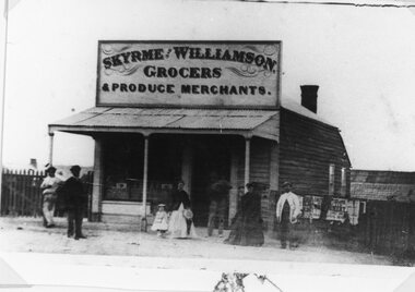
Photograph, Skyrme & Williamson -- Grocers and Produce Merchants in Main Street Stawell
Skyrme & Williamson Grocers and Produce Merchants Main Street Stawell along from St George Street corner but before the Town Hall Hotel.stawell businesses -
 Stawell Historical Society Inc
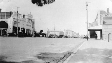
Photograph, Main Street Stawell looking East from St Georges Street with McClure's Garage, Post Office & the State Savings Bank on right 1930
Main Street Stawell McClure's garage Post Office State Savings Bank on Right. 1930 looking East from St Georges Streetstawell businesses streetscape -
 Stawell Historical Society Inc
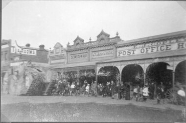
Photograph, Main Street Stawell with a Crowd Scene around an Army WW1 Tank 1919
Main Street Stawell. Crowd Scene with Army WW1 Tank. 1919. In front of C.C. McDonald Tobacconist. E.J. Copley Post Office Hotel. stawell streetscape ww1 -
 Stawell Historical Society Inc
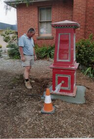
Photograph, Red Post Box previously located at Corner of Patrick St and Main Street 1874 being located at Historical Society Gardens by Paul Cuffe -- Coloured
Red Post Box previously located at Corner of Patrick St and Main Street 1874 being located at Historical Society Gardens by Paul Cuffepost office, mail -
 Stawell Historical Society Inc
Postcard, Top End of Main Street Stawell
Main Street Looking West past Bull and Mouth Hotel. Kays Star Hotel on right c1907 Carters Boots. Same as 6730-3stawell, streetscape -
 Stawell Historical Society Inc
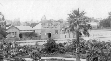
Photograph, John Stratton's Wool and Skin Store Commission Agent in Lower Main Street Stawell
John Stratton's Wool and Skin Store Commission Agent in Lower Main Street Stawell. Photo taken from Central Park No1 Grandstand.stawell -
 Stawell Historical Society Inc
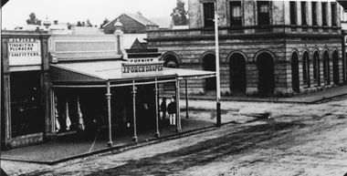
Photograph, Main Street Stawell near Post Office
Main Street near Post Office. Gentlemen on sidewalk outside Chemist on the corner which is mainly hidden by J Porch Drapers sign and verandah.stawell businesses streetscape -
 Stawell Historical Society Inc
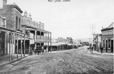
Photograph, Main Street Stawell looking West from opposite Star Lane 1906
Main Street looking West from opposite Star Lane 1906. Scaffolding and Barrow on left is from building the Bull and Mouth Hotel 1906 stawell businesses streetscape -
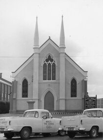 Stawell Historical Society Inc
Photograph, Stawell Methodist Church in Main Street Stawell with Holden utes in the front c1960s
Stawell Methodist Church. Main Street Stawell. Macs Tyre Service Holden utes in front. Late 1950's or early 1906'sstawell -
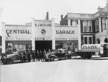 Stawell Historical Society Inc
Photograph, Mr R J McClure's Central Garage in Main Street Stawell with Staff 1936
R.J. McClure Central Garage. Main Street. Oct 6 1936. Petrol Bowser Tanker and Cars in front with staff. Town Hall visible.stawell -
Stawell Historical Society Inc
Photograph, Stawell Aerial View Centred on Town Hall in Main Street 1998 -- Coloured
Colour Aerial View of Stawell 1998 Centred on Town Hall. Main Street. Scallan Street Childe Street Houston Street and Ligar Street.stawell -
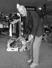 Stawell Historical Society Inc
Photograph, Mr Alf Hunt with a cricket bat in Raitts Sports store in Upper Main Street previously, the Hunt family business
Alf Hunt with Cricket bat in Raitts Sports store upper Main Street. It was the Hunt family business C Hunt and Son for many years.stawell -
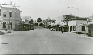 Stawell Historical Society Inc
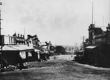
Photograph, Main Street Stawell looking East from west of Wimmera Street
Stawell Main Street looking East from west of Wimmera Street. Post office on left Post Office Arcade on right. Vehicles in distance.stawell streetscape -
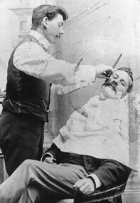 Stawell Historical Society Inc
Photograph, Mr George Giles shaving his brother Mr Charlie Giles in their Hairdressing Business in Main Street Stawell
Hairdressers - George Giles shaving his brother Charlie Giles. Business was in Main Street Stawell between the Town Hall and Holy Trinity Church.stawell -
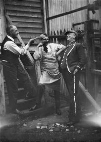 Stawell Historical Society Inc
Photograph, Three men in Fancy dress -- behind W Carters Boot Shop in Main Street 1922
Three men in Fancy dress 1922 taken behind W Carters Boot Shop Main Street. Probably `William Henry Carter on the left.Black and white photograph on a grey mount card with a lined border. The photo is a candid shot of 3 men. Two are in costume and looking jovial while the man standing on the step is more serious and pointing at one of the men. The timber stairs are leading to a timber building and behind the two in fancy dress is a picket fence 1922 W. Carter shop?stawell -
 Glen Eira Historical Society
Album - Album page, Bureel (Kooyong Road), Circa 1972
This photograph is part of the Caulfield Historical Album 1972. This album was created in approximately 1972 as part of a project by the Caulfield Historical Society to assist in identifying buildings worthy of preservation. The album is related to a Survey the Caulfield Historical Society developed in collaboration with the National Trust of Australia (Victoria) and Caulfield City Council to identify historic buildings within the City of Caulfield that warranted the protection of a National Trust Classification. Principal photographer thought to be Trevor Hart, member of Caulfield Historical Society. Most photographs were taken between 1966-1972 with a small number of photographs being older and from unknown sources. All photographs are black and white except where stated, with 386 photographs over 198 pages. From: Glen Eira Heritage Management Plan 1996 by Andrew Ward In 1856, John Allee, a builder from Brighton, purchased C.A. 37 on the south-west corner of Glenhuntly and Kooyong Roads. The land comprised just over 45 acres. By 1863, Francis John Sidney Stephen, a lawyer and cousin of J. Wilberforce Stephen, owned most of lot 37. By 1866, Stephen had a built a "small mansion" named ''Burreel". It was a brick house and Stephen lived there until 1882. By 1884, Mrs Buxton of Hillside Terrace, East Melbourne, had purchased the property. Richard Buxton, a gentleman was listed as occupant and the house described as "brick, eight rooms". NAV was £300. Richard Buxton continued residency in 1887 however in 1888, George Allen, music seller, became occupant. At that time the house had thirteen rooms on twenty-three acres of land. Twelve people lived there and NAV was £920. In 1900, Daniel Luxton, stock and sharebroker and the Honourable John Taverner, M.H.A. leased the property. Fourteen people lived there. Mrs Buxton continued as owner. By 1910, ownership had passed to Mrs Mary Neate, who converted the house to a nursing home. The land had been subdivided by 1913 and sold by ''Buxtons Estate". Burreel Avenue, Baxter, Buxton and Hoddle Streets were created. "Burreel" was rated to Burreel Avenue and stood on lot 13 with frontages to Burreel Avenue and Kooyong Road of 198' and 214'. The house had ten rooms. NAV was £60. Mary Neate, a nurse, continued as owner/ operator of ''Burreel" nursing home in 1927. At that time there were sixteen rooms and fourteen residents. NAV was £100. Mrs Neat remained there until 1947. In 1948, the house was turned into apartments. In the 1980's, the Alexander family purchased it and restored it to a private residence.Burreel 331 Kooyong Road, ELSTERNWICK VIC 3185 - Property No B4950 National Trust https://vhd.heritagecouncil.vic.gov.au/places/65648 This is a large and substantially intact example of the grand villas of nineteenth century Melbourne. The bulk of the house most probably was built in 1866-1868 for Francis John Sidney Stephen, a prominent and highly regarded Melbourne solicitor and a member of an illustrious legal family. Stephen conducted a lucrative private practice and in 1845 was appointed first solicitor to the City of Melbourne; a position he held until his death in 1895. He took an active part in the development of Caulfield and was Shire President in 1874 and 1877. He was a resident at Burreel from 1868 to 1882. The house has evolved in stages, the rear wings possibly remaining from a house built during the 1850s. The existing ornate cast iron verandah was probably built between 1882 and 1888 during the residence of Richard Buckhurst Buxted, a notable boom period auctioneer and real estate agent. George Allan, the founder of Allan's music store, was another important occupier from 1888 to 1991. Bureel's essentially residential quality has been retained and the interior has been well preserved. The significance of this building does not rest in any single unusual outstanding architectural feature, or in its association with a particularly prominent member of society in the past, but rather in the consistent integrity of both the interior and exterior, which results in the survival of an outstanding example of this type of residential building and its associations with two notable citizens. Classified:11/08/1990Page 113 of photograph album with 1 photograph of Burreel in its garden.Handwritten: Bureel [top left] / 113 [bottom left]trevor hart, caulfield, caulfield north, kooyong road, thomas king, mansion, 1860's, bureel, burreel, francis john sidney stephen, city of melbourne, shire president, 1850's, verandah, nursing home, john allee, ornamented corner stones, new orleans manner, plaster rendered, mrs luxton, vincent willis, alexander family, victorian architectural style, ornate cast iron work, lawyers, brick houses, richard buxton, richard buckhurst buxton, george allen, george leavis allan, allans music, daniel luxton, john taverner, mary neate, buxtons estate, land subdivision, mary neat, gardens -
 Ringwood and District Historical Society
Article - Newspaper Clipping, Land Sale Advertisements, Golden Hill Estate, Ringwood - 1965, 1966, and Plan of Survey of Lot 8, Mullum Mullum Road Ringwood, 1970
Newspaper clippings from Melbourne Sun newspaper (11th December 1965 and 15th January 1966) advertising sale of land - Golden Hill Estate, Ringwood, with summary of features and aerial photograph including artistic representation of street layout. Subdivision includes Mullum Mullum Road, Sonia Street, Jill Court, Linda Drive, Eve Court, Alma Court, and Jacynthe Court. Attachments include reference to Lot 46 as site of original Peter Vergers' orchard residence and subsequent 1970 surveyor's Plan of Survey of Lot 8 Mullum Mullum Road Ringwood, LP 67513, Cert of Title 8581/429.Agent - Aaron, King & Co., Suite 2, 33 Queens Road, Melbourne. (Phone) 26-2443, A.H. 850-2195. Plan of Survey signed on 25.7.1970 by Roger M. Gamble, Land Surveyor, 28 Summit Crescent, Ringwood 3134.