Showing 7072 items
matching snowy-river
-
 Bendigo Historical Society Inc.
Map - JANIEMBER WEST : COUNTY OF BENDIGO, September 1955
Map. Janiember West, County of Bendigo. Loddon River, Janiember East, Powlett, Kinypanial, Jarklan. Welsh's Lagoon. By authority W.M. Houston, Government Printer, Melbourne. Drawn and reproduced at the Department of Lands and Survey, Melbourne, September 1955, Price 5/-. (number 66 in map cupboard 1)W.M. Houston, Government Printer, Melbourne.map, bendigo, janiember west -
Bendigo Historical Society Inc.
Map - TARNAGULLA : COUNTY OF BENDIGO, 1959
Map. Tarnagulla, County of Bendigo, Sheet 3, Kingower, Glenalbyn, Inglewood, Loddon River, Derby, Gladstone. Drawn and reproduced at the Department of Lands and Survey, Melbourne, 1959. Price 5/- per sheet. By authority A.C. Brooks, Government Printer, Melbourne. (number 35 in map cupboard 1)A.C. Brooks Government Printer, Melbourne.map, bendigo, tarnagulla -
Bendigo Historical Society Inc.
Map - BRIDGEWATER : COUNTY OF BENDIGO, 6-10-27
Map. Bridgewater, County of Bendigo, Inglewood, Salisbury, Derby, Leichardt, Yarraberb, Yarrayne, Bullock Creek, Loddon River, Sandhurst and Inglewood Railway. Photo-Lithographed at the Department of Lands and Survey Melbourne by W.J. Butson, 6-10-27. Price 1/-. (number 53 in map cupboard 1)W.J. Butsonmap, bendigo, bridgewater -
 Bendigo Historical Society Inc.
Postcard - ACC LOCK COLLECTION: B&W PHOTO OF RIVER AND DESTROYED BRIDGE, POSTCARD, CARTE POSTALE, 1914-1918
Postcard, B&W photo of an iced over river with a destroyed bridge in foreground. Buildings on the left. Covering of snow all over. Handwritten in pencil on the back, I2 - The Lys and destroyed bridge between Bac St Maur and Croix du Bac (near Armentieres) G15 (crossed out)postcard, postcard, ww1, river lys, bac st maur, croix du bac, armentieres -
 University of Melbourne, Burnley Campus Archives
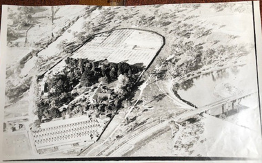
Photograph - Black and white print, Aerial View of Burnley Campus c. 1930, c. 1934
Black and white photographs. Aerial Views of Burnley Campus. Enlargements. (A) Heyington Bridge to South, Yarra River on North side. (B) Heyington Bridge at top of photograph i.e. reverse view of (A). (C) Original of (B) mounted on board. Probably taken at the time of the floods of 30 November 1934. heyington bridge, yarra river, aerial view, burnley campus, 1934 flood -
 Wodonga & District Historical Society Inc
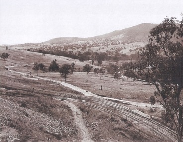
Album - Hume Reservoir Australia Album - Valley of the Murray to be crossed by the Bethanga Bridge 1927
This set of photos is from a leather bound album bearing the inscription "HUME RESERVOIR AUSTRALIA" plus 'The Rt. Hon. L. C. M. S. Amery, P. C., M .P.' all inscribed in gold. It was presented to The Rt. Hon. L. C. M. S. Amery, P. C., M. P, Secretary of State for Dominion Affairs on the occasion of his visit to the Hume Reservoir on 2nd November 1927. This album is of local and national significance as it documents the planning and development of the Hume Reservoir up to 1927. It was the largest water reservoir in the British Empire. The album records the pioneering engineering work that went into its construction.DEPARTMENT OF PUBLIC WORKS, N.S.W. RIVER MURRAY WATERS SCHEME. HUME RESERVOIR. 36. Valley of the Murray to be crossed by the Bethanga Bridge described in the next photograph. (WHS 00731) This view shows the marshalling sidings for trucks below the Quarry, New South Wales, and the branch line to the site of the bridge.hume reservoir australia, river murray waters scheme, hume reservoir construction -
 Lakes Entrance Historical Society
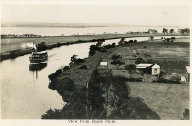
Postcard - Eagle Point, 1930 c
Black and white postcard S S Gippsland in Mitchell River, travelling towards Bairnsdale, silt jetties extending eastwards small farm, farm house and sheds on right. Jones bay in Middle distance beyond silt jetty, taken from Eagle Point Bluff. Bairnsdale VictoriaView from Eagle Point. ships and shipping, waterways, agriculture, houses -
 Greensborough Historical Society
Map, Melbourne and Metropolitan Board of Works. Survey Division, MMBW, Yarra 2500 / 12.24. Plenty and Blue Lake, 1977_10
Melbourne and Metropolitan Board of Works. Yarra 2500 [base map]. 12-24, Municipalities of Whittlesea 239 and Diamond Valley 257. Shows street names, easement sizes, lot numbers, lodged plan numbers, names of prominent features, contour values, creek or river names. Watsonia Railway Station and environs. Prominent streets: Memorial Drive. Includes Plenty River and Blue Lake in the Plenty Gorge.MMBW Map in 1:2500 [scale] series. Cream parchment with green tape reinforcing on edges and punched holes on left edge.mmbw, melbourne and metropolitan board of works, shire of diamond valley, plenty - maps, blue lake -
 Halls Gap & Grampians Historical Society
Newspaper - B/W, 26/01/2001
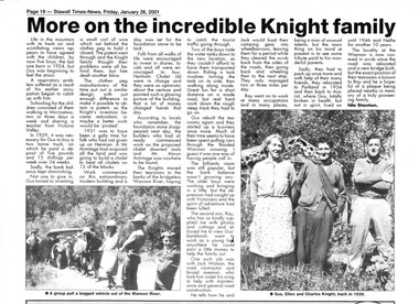
This is a newspaper article written by Ida Stanton for the Stawell Times-News "Halls Gap Extra" and published on Friday, 26 January 2001, p.18. It refers to Gus Knight and his family when they lived at Henham and on the Wannon River. The photos included in the article show: 1) a bogged vehicle being pulled out of the Wannon River by a large group of people; and 2) Gus, Ellen and Charles Knight in 1939.A newspaper article headed "More on the incredible Knight Family", containing two photos.people, knight -
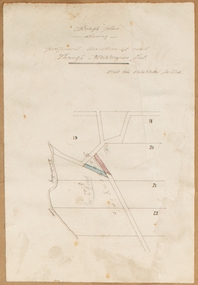
![Map, Plan showing proposed deviation of the road through McKenzie's Flat to Bacchus Marsh. [Undated]](/media/collectors/5e461d8021ea67224c82f2a1/items/677d22f37f2053f3e5d500dc/item-media/677d25247f2053f3e5d50950/item-fit-380x285.jpg) Bacchus Marsh & District Historical Society
Bacchus Marsh & District Historical SocietyMap, Plan showing proposed deviation of the road through McKenzie's Flat to Bacchus Marsh. [Undated]
The date of this map or plan is uncertain. McKenzie's Flat is a bushland picnic area on the Lerderderg River in the Lerderderg State Park close to Bacchus Marsh. The proposed road deviation shown on this map is very close to a sharp bend in the Lerderderg River which shows an island in the centre of that bend. The name of a landholder, J.B. Perry is shown on the map close to the area of the road deviation.The land shown is identified as within the Parish of Merrimu.Single page map showing a proposed deviation of the road from McKenzie's Flat to Bacchus Marsh. Scale: 5 chains to 1 inch. Part of a set of maps which are pasted into a bound volume containing 76 maps or plans in total. High resolution digital image stored on BMDHS computer network. mckenzies flat bacchus marsh, bacchus marsh roads and streets -
 Kiewa Valley Historical Society
Folder - Family History, The Maddison Family, 1968 and later
George Maddison selected land in 1877 between the East and West Kiewa branches of the Kiewa River - known as the "Island". Now Mt Beauty.Pioneer family in the Kiewa ValleyPlastic brown folder with transparent front held by 2 gold metal slide clips. 9 clear plastic sheets holding 4 typed sheets, 3 typed sheets by Ted Maddison 1968, 4 handwritten pages in 1 plastic sleeve and 6 handwritten pages in 1 plastic sleeve (the handwritten sheets are the same as the typed sheets.)maddison family; mount beauty; kiewa valley -
 Eltham District Historical Society Inc
Photograph, Fay Bridge, Longridge, Alexander Road, Warrandyte, 4 May 2019
Situated on the Warrandyte side of the Yarra River opposite Glynn's Dairy Farm, North Warrandyte, the property is in ruins and remains fenced off as of 2023fay bridge collection, glynns, longridge, ruins, warrandyte, 2019-05-04, alexander road -
 Greensborough Historical Society
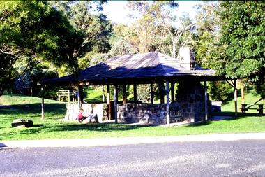
Slide - Photograph, John Ramsdale, Picnic shelter, Pioneer Reserve: Slide 22, 1990s
Photograph shows Pioneer Reserve picnic shelter in Greensborough. This shelter was built from bluestones from the old bridge over Plenty River.Part of the John Ramsdale collection of slides and audio visual material.Colour photograph scanned from slide.No maker's marks. No caption on slide.plenty river, bluestone bridge greensborough, pioneer reserve greensborough -
 Greensborough Historical Society
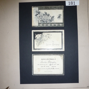
Bereavement Cards, Charles Partington, died March 13th 1905, 13/03/1905
Charles Partington came to Greensborough with his family in the 1857 to farm along the Plenty River. Members of his family still live in the area.A memory of a Greensborough pioneer, these cards are an example of bereavement cards in the early 20th century3 x black and white bereavement cards (possibly accompanied floral tributes). "Sacred to the memory of Charles Partington who departed this life March 13th 1905. Aged 80 years and was later interred in the Strathallan Cemetery"charles partington, ellen whatmough, partington family, bereavement cards -
 Greensborough Historical Society
Map, Municipality of Heidelberg Plan No. 481, 23/9/1949
Central area of Greensborough, South boundary Grimshaw Street, showing river and buildings in green and gradients in red. Adjoins Map No. 480 to West.Black & white map with features in red and green. Scale: 160 feet to 1 inch.greensborough, grimshaw street greensborough -
 Greensborough Historical Society
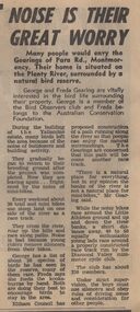
Newspaper Clipping - Digital Image, Noise is their great worry, 21/08/1973
A family living near the Plenty River in Montmorency are concerned about the noise of mini-bike riders and their effect on local bird life. [1973]Digital copy of newspaper article, black text.plenty river montmorency, montmorency -
 Greensborough Historical Society
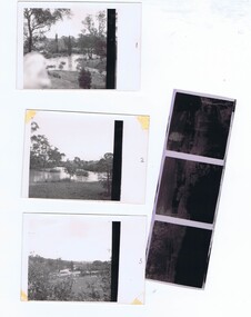
Photographs and Letter, Greensborough 1960s, 1960s
Taken during a flood in the late 1960s, showing parts of both old and new bridge across the Plenty River, kiosk and Fitton house.Three photographs, with negatives and covering letter from Tony Fitton, with handwritten descriptive lettergreensborough, plenty river greensborough, fitton family -
 Greensborough Historical Society
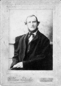
Photograph - Digital image, Charles Partington, 1880s
Charles Partington and family came to Melbourne in the 1857 and moved to Greensborough where they farmed along the Plenty River. Descendants still live in Greensborough.A pioneer Greensborough family.Digital copy of black and white studio photograph.charles partington, partington family -
Greensborough Historical Society
Compact disc, Heritage Victoria Application, 2007_
Application for grant from Heritage Victoria including supporting material. Dated 2007. The application deals with the proposed Plenty River Heritage Trail.An example of a grant application.1 compact disk with text files."Heritage Victoria Application"heritage victoria, grant application, noel withers, plenty river, plenty river heritage trail -
 Greensborough Historical Society
Newspaper clipping, Fiona Cameron, Pioneer bridge is demolished, by Fiona Cameron, 1974_
Describes the removal of the bluestone bridge abutment on the north side of the Plenty River in Greensborough, to make way for the Diamond Creek Road bridge duplication.Photocopy of news articleplenty river, diamond creek road -
 Halls Gap & Grampians Historical Society
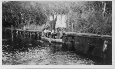
Photograph - B/W, C 1933
The photo shows the Wannon River in flood. Augustus (Gus) Knight built the footbridge. The boat was constructed using kerosene tins or honey tins.Photo shows five adults, four standing and one squatting, on a foot bridge. There are four children in front of them in a boat.structures, bridges -
 Kiewa Valley Historical Society
Photo: Making of Kiewa Valley Highway at Tawonga
The Kiewa Valley Highway was/is a major road along the Kiewa River ending at Mt Beauty the site of the S.E.C.V. town built for the construction of the K.H.E.S.Black and white photo with roofless old car beside two horses pulling a cart with man behind the cart. All coming towards the photographer on a road with paddocks on each side.kiewa valley highway, road building -
Tatura Irrigation & Wartime Camps Museum
CD, 1961 State Rivers and Water Supply Commission Water Loss Report to Victorian Government Public Works Committee
Donor F.L. Burns was a design engineer with State Rivers and Water Supply Commission and wrote, as part of a report, "methods of reducing seepage losses".Silver disc. Black text. Inside a black and clear plastic rectangular cover.irrigation, victoria state rivers and water supply commission -
Tatura Irrigation & Wartime Camps Museum
Folder, Articles on History of Waranga Basin, 2000
Extract from Waranga News on early history of Waranga Basin. Maps. Other stories of families at Basin, Goulburn River and Goulburn WeirBlue cover. Black spiral spine. White label. Title in blue penhistory of waranga basin, knee l, tatura, irrigation, books, history, local, rural -
Tatura Irrigation & Wartime Camps Museum
Book, First Overlanders - Hawdon and Bonney, 1991
Written to commemorate the early drovers and the use of river crossing near Wentworth, NSW. The route was later used by noted explorers - Eyre and Sturt.Pale green front cover depicting inscription on Hawdon monument at Wentworth, NSW.first overlanders, first cattle drive, k kain, wentworth nsw, eyre and sturt explorers -
 Vision Australia
Photograph - Image, Portrait of Graeham Goble
Musician Graeham Goble performs at an unknown event, possibly supplied for the Carols by Candlelight program when the Little River Band played in 1982.B/W photograph of Graham Goble.carols by candlelight, graeham goble -
 Port Fairy Historical Society Museum and Archives
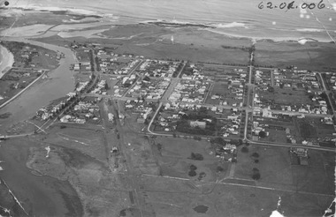
Photograph, 1940's
The photograph depicts the river, bridge, rail line, Regent Street, Sackville Street, William Street and south west passage and pudney groundsSignificant for its depiction of the layout of the town in the 1940's and the river and south west passageBlack and white photograph Oblique Port Fairy Streets looking SouthALEX WILKINS PHOTOGRAPHER WARRNAMBOOL O.G.Powell Chemist Phone 88 Port Fairy Handwritten- Aerial View to be enlarged to 12" wide underlined 62.01.006 written on front of picturemoyne river, sackville street, william street, south west passage, pudney gorunds -
 Greensborough Historical Society
Photograph - Photograph - Digital Image, Marilyn Smith, Greensborough trees 2020, 24/08/2020
Digital image of trees at Greensborough 24/08/2020, This image shows the trimmed trees near the Plenty River and Main Street GreensboroughPart of a collection of miscellaneous historical images with a connection to the local area.Digital colour photograph. plenty river, trees - greensborough -
 Bacchus Marsh & District Historical Society
Map, Rough plan showing proposed deviation of road through McKenzie's Flat
The date of this map or plan is uncertain. McKenzie's Flat is a bushland picnic area on the Lerderderg River in the Lerderderg State Park close to Bacchus Marsh. Single page map showing a proposed deviation of the road near the McKenzie's Flat area close to Bacchus Marsh. The proposed deviation is shaded in pink, The existing road section to be replaced is shaded in blue. No scale is indicated. Part of a set of maps which are pasted into a bound volume containing 76 maps or plans in total. High resolution digital image stored on BMDHS computer network. mckenzies flat bacchus marsh, bacchus marsh roads and streets -
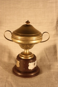 Otway Districts Historical Society
Memorabilia - Trophy, Plate Craft, Otway Tennis Association, B grade Junior Premiers, c.1962
Trophy. Otway Tennis Association, B Grade Junior Premiers. An EPAINS lidded-cup with handles on a round bakelite base, with the names of winning teams from 1963/64, 1975/76, and 1982/83 to 1987/88 inclusive.1963/64 Beech Forest B 1975/76 Lavers Hill 1982/83 Johanna 1983/84 Carlisle River 1984/85 Lavers Hill 1985/86 Lavers Hill 1986/87 Wyelangtatennis, otway tennis association, lavers hill, beech forest, johanna, carlisle river, wyelangta