Showing 10390 items
matching plan
-
 Ballarat Tramway Museum
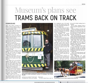
Newspaper, Edwina Williams, "Museum's plans see Trams back on track", 9/07/2020 12:00:00 AM
Digital image of an item in the 9-7-2020 issue of Ballaarat Times, titled "Museum's plans see Trams back on track" about the planning to re-open the museum following the lifting of restrictions due to Covid-19. Includes notes on the operation of the trams from the depot only and limitations. But these came to naught when the plan to lift restrictions did not go ahead and there was a further lockdown in the Melbourne area. Has a photo of Peter Waugh standing on a step of No. 13 with a limitation sign on it.btm, closure, covid-19 -
 Bialik College
Plan (item) - Bialik College, 1970s
Two boxes of architectural plans of proposed Bialik College, 429 Auburn Road, Hawthorn East, created by architects Joshua and Mary Pila, c. 1970s. Box 1: 1970s, Box 2: 1979. Please contact [email protected] to request access to this record.1970s, building and planning -
 Kew Historical Society Inc
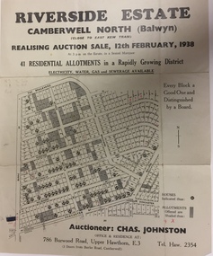
Plan - Subdivision Plan, Riverside Estate, Camberwell North (Balwyn), 1938, 1939
This subdivision known as the Riverside Estate wa sone of the largest and most significant in Balwyn's history.Subdivision Plan for 41 lots within the wider Riverside Estate in Camberwell North, now Balwyn, in February 1938. The auction featured lots in Burke Road, The Boulevard, Mt View Road, Wattle Avenue, Kyora Parade, Cascade Street, Riverside Avenue, Walbundry Avenue, Inverness Way, Bulleen Road and Doncaster Road.Allotments for sale are shaded grey on the map. Certain lots have an H in a circle. These are presumably where houses had already been constructed.subdivision plans - balwyn (vic), riverside estate - balwyn (vic) -
 Ringwood and District Historical Society
Newspaper, Scrapbook Clipping, Library Collection, Ringwood, Victoria, `
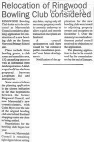
``Newspaper clipping from The "Post" , 18-1-95 P3. Relocation of Ringwood Bowling Club consideredRingwood Bowling Club looks set to be relocated as Maroondah Council considers a planning application for construction of a new bowling club on the former Norwood Primary School site.` -
 Old Castlemaine Schoolboys Association Inc.
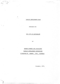
Document, George Hibbert and Associates, The Hibbert Report
TOURIST DEVELOPMENT PLAN PREPARED FOR THE CITY OF CASTLEMAINE BY GEORGE HIBBERT AND ASSOCIATES TOURIST DEVELOPMENT ENTERPRISES 53 MILTON ST. ELWOOD. 3184. VICTORIA. November, 1972. -
 Bendigo Historical Society Inc.
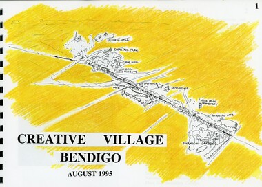
Book - MERLE HALL COLLECTION: ROSALIND PARK CREATIVE VILLAGE BENDIGO PROJECT BOOK, 1995
Merle Hall Collection: Rosalind Park Creative Village Bendigo Project Book. August 1995 Book contains a description, aims of the programme and a linking plan. 35 Pages: Cover Intoduction, The Design Team, Acknowledgement Project Brief Map of Linked Park The Linking Plan described Linking plan graphic Golden Beacon Design Concept Bridge Beacon Entrance to Linear Park Gasworks Café Pavillion Gasworks layout plan Golden Beacons Concept Botanical Gardens Café Botanical Gardens layout plan Victoria Hill Interpretation Centre Victoria Hill layout Victoria Hill plan Victoria Hill continued Victoria Hill continued Rosalind Park Lookout Method 3D Road Map 3D Road Map Continued Implementation Community Participation Oppurtunities, Mosaic Works Appropriate sites Appropriate sites continued Consultaion Summary and Issues Ideas Areas for further consideration Graphic The Design Team - Grant Fink, Jane Marriott, Laszo Biro, James Brearley Graphic Layoutbook -
 NMIT (Northern Melbourne Institute of TAFE)
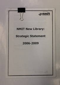
Report - NMIT, NMIT New Library: strategic statement 2006-2009, August 2006
A collection of documents and reports related to the NMIT library strategic plan 2006-2009. This plan recognises changes to library service and sets down the plan for NMIT libraries in the first decade of the 21st century. Includes 2 copies of Library Operational Plan August 2007The role of libraries and librarians changed in response to changing client expectations, and new and emerging technologies. This document is NMIT's strategic plan to deliver services relevant to the needs of its clientele.A collection of documents and reports, text printed on white paper. Each document stapled in top left corner, collection held together with large clip.Some passages highlighted with pencilled stars.libraries, student focus in libraries, library operational plan, library staff, nmit, -
 Bendigo Historical Society Inc.
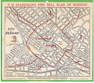
Document - FIRE BELL PLAN OF BENDIGO
Plan Document. A Fire Bell Plan of Bendigo issued by F.H.Sparkman. A street map of Bendigo split up into a central zone plus four surrounding zones. It is probably the upper part of a calendar with the date section missing (torn off). F.H.Sparkman was a printer and a Mason. Date not shown but probably prior to 1950F.H.Sparkmanessential services, firefighting, fire bell plan of bendigo, fire bell plan, f.h.sparkman -
 Bendigo Historical Society Inc.
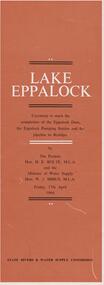
Document - LAKE EPPALOCK - OPENING CEREMONY PROGRAM
Folded document, 5 pages, produced to commemorate the opening of the Eppalock Dam, the Eppalock Pumping Station and the pipeline to Bendigo, by the Premier, Mr. H. Bolte, on 17th April, 1964. Brown cover, cream and black text. Illustrations show the cross section of the tunnel; a plan of the embankments and an overall plan of the weir.bendigo, waterworks, lake eppalock -
 Warrnambool and District Historical Society Inc.
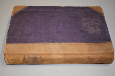
Letter book 13, 1920
This letter book contains letters, sketch maps and plans and dates from 1920 to 1923. It came from the office of John William Crawley Junior, an engineer, architect and surveyor in private practice in Warrnambool and also the engineer for the Shire of Warrnambool from 1895 to 1935. His father, brother and son were also engineers and worked in that capacity or as the Shire Secretary for the Shire of Warrnambool, with the Crawley family recording a total of 132 years of service to the Shire. The letter book was passed onto John Crawley’s son, Rolf, the engineer for the Shire of Warrnambool from 1935 to 1968. It then came into the possession of Michael Hand who took over the private surveying business on Rolf Crawley in Warrnambool. The Warrnambool and District Historical Society acquired the letter book, along with several other Crawley ledgers, from the estate of Michael Hand. This letter book is of considerable significance as it contains letters and maps drawn up by John William Crawley, an engineer in the Shire of Warrnambool for 40 years. It will be very useful for researchers.This is a dark red hard- cover letter book of 1001 pages. The book has brown binding on the corners of the cover and on the spine. There is gold lettering on the spine. The inside of the cover is lined with a multi-coloured mottled pattern. The cover is stained and scuffed. The pages contain handwritten letters, sketch maps and plans and an alphabetical index at the front. There are three loose pages. There is a mauve stamp on the first page.‘Letter Book 1920 to 1923’ ‘Rolf. L. Crawley Civil Engineer, Drainage and Water Supply Engineer, Licensed Surveyor, Registered Architect, Warrnambool’ john william crawley junior, warrnambool, rolf crawley, warrnambool, shire of warrnambool -
Bendigo Historical Society Inc.
Plan - MARKS COLLECTION: UNDERGROUND SURVEY OF MINES SANDHURST NEW CHUM LINE OF REEF
Plan, divided into two sheet, on top of sheet Underground survey of mines Sandhurst, New Chum Line of Reef. Surveyed by Caleb Thomas under the direction of Charles W. Langtree, Acting Secretary for Mines and Water Supply and Acting Chief Mining Surveyor for the Colony of Victoria. Drawn by Arthur Everett, Mining Department, Melbourne, 1884.bendigo, mining, new chum line of reef -
Bendigo Historical Society Inc.
Plan - SANDHURST BOYS CENTRE COLLECTION: PLAN OF MAINTENANCE WORKSHOPS
Victoria Public Works Department. Sandhurst Boys Centre. Maintenance workshops plan, elevation & section, Scale 1:100. Elevation includes tea room, lockers bathroom; ladder store; glaziers workshop; paint shop & paint store; carpentry workshop; machine area; offices, store rooms; mechanical workshop. Location unknown 16.02.2023.bendigo, institutions, sandhurst boys centre, sandhurst boys centre site plans; maintenance workshops; loddon-campaspe regional service; victoria public works department -
University of Melbourne, Burnley Campus Archives
Plan, AMRAD Burnley Development Civil Drawings, 1997-1998
Job No 74046 New Laboratories & Offices Building 5 & 9 AMRAD Burnley Development, for AMRAD Operations Pty. Ltd. By Scott Wilson Irwin Johnston. (1) C1 Drawing Index, Legend & General Notes, Nov 97. (2) C2 Pavement & Drainage Plan 03.98. (3) C3 Pit Schedule & Pavement Details 03.98.scott wilson irwin johnston, amrad, johnston merat kurdiovsky architects, amrad burnley development -
 Flagstaff Hill Maritime Museum and Village
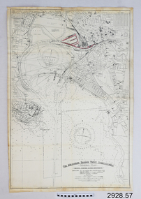
Document - Navigation Chart, The Melbourne Harbor Trust Commissioners
Navigation Chart - The Melbourne Harbor Trust Commissioners - General Plan - Shewing proposed Harbor Improvements. Hobson's Bay and Citywarrnambool, shipwrecked-coast, flagstaff-hill, flagstaff-hill-maritime-museum, maritime-museum, shipwreck-coast, flagstaff-hill-maritime-village, shipwrecked-artefact, navigation chart, hobson's bay, the melbourne harbor trust -
 Greensborough Historical Society
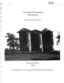
Booklet, Sera Jane Peters, Viewbank Homestead, Heidelberg: an historical survey, by Sera Jane Peters for Heritage Victoria, Department of Planning and Development, 1996
History of the Viewbank Homestead, originally a 90 acre site with homestead and outbuildings, now demolished.Black and white photocopy of typescript, with photographs, plans, reproductions of documents. 25 p plus 17 p of Appendices, unboundviewbank homestead, heritage victoria -
 Phillip Island and District Historical Society Inc.
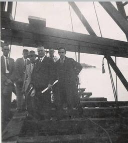
Photograph
One of a collection of over 400 photographs in an album commenced in 1960 and presented to the Phillip Island & Westernport Historical Society by the Shire of Phillip IslandPhotograph of men at the ceremony of the driving of the first pile for the first Phillip Island Bridge - Mr Richard Grayden holding plan.local history, photographs, group of six men on timber framework, black & white photograph, phillip island bridge, first pile driving ceremony, mr r a grayden, first phillip island bridge to san remo, john jenner, bryant west -
Glenelg Shire Council Cultural Collection
Book, Benedict, What To Do At Weddings, c. 1951
Small booklet, a guide for brides, grooms and others involved in wedding planning. Grey card cover, red and navy print. -
4th/19th Prince of Wales's Light Horse Regiment Unit History Room
Booklet (2 copies), Central Drawing Office, Infantry Training Vol 1 Infantry Platoon Weapons Pam 3B The 7.62 Self Loading Rifle and Bayonet, 1961
A soft covered booklet containing the material necessary to equip an instructor on the weapon. The booklet is set out in lesson plan format.7610-66-013-1640rifle 7.62 slr -
Ringwood and District Historical Society
Envelope, Packet: Town Planning Act 1944 and Greater Melbourne Printed Matter and Correspondence
Packet 2 (of 2); Town Planning Act 1944 Municipal Administration Institute Pamphlets and minutes of general meetings; Correspondence -
Ringwood and District Historical Society
Legal record - Conditions of Sale (C.E.Carter), Mitcham - Crown Allotment 124. M.E.Burke to ? Dated June 1st 1929
Particulars and Conditions of Sale of Property , Lot 44 and 45 on Plan of Subdivision 6736, Mitcham Road, Mitcham. Mrs M.E.Burke to ? -
Federation University Historical Collection
Book, City of Ballaarat Planning Scheme Review: Planning Policies Identification Summary Report, 1980, 02/1980
Brown soft covered book outlining the City of Ballarat Planning Scheme Review . Includes black and white images and a map.city of ballaarat, city of ballarat planning, planning scheme review, map -
Federation University Historical Collection
Poster, University of Ballarat Camp Street Campus, 2000, 2000
The University of Ballarat became Federation University Australia in 2014. The Camp Street Campus was later known as the Arts Academy. Framed poster of a collage of images showing plans for the University of Ballarat Camp Street Campus, later known as the Arts Academy. "In acknowledgement of the joint agreement to redevelop historic camp Street as a dynamic arts precinct utilising the central business district area of Ballarat."arts academy, camp street precinct, camp street, arts precinct -
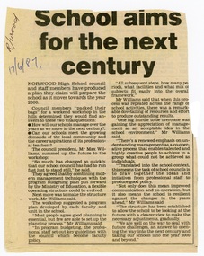 Ringwood and District Historical Society
Newspaper - Clipping, Norwood High School, Ringwood, Victoria - "School aims for the next century"
Newspaper report June1987 outlining 21st century planning workshop topics addressed by council president Mr Max Williams. -
Bendigo Historical Society Inc.
Document - NEW CHUM LINE OF REEF - REFERENCE FOR CALEB THOMAS PLANS
Two handwritten pages of reference numbers for Caleb Thomas plans. The numbers refer to mines on the New Chum Line of Reef.document, gold, new chum line of reef, new chum line of reef, reference for caleb thomas plans, new chum bellevue & railway reserve, bellevue & new chum, shenandoah, shamrock, old chum, little chum, new chum trib, young chum, cravens, garibaldi, no 1 ellesmere coy, new chum consolidated, ellesmere, new chum united, lansell's 222 (denis), lansell's 222 (new shaft), koch & hildebrandt (lansell's 222), lazarus co, sheer legs, old chum, new chum & victoria, north old chum, lansell's 180, victoria quartz, gt cent vic, victoria consols, victoria reef co (ironbark), hercules, energetic ladder shaft, energetic shaft -
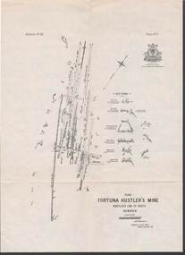 Bendigo Historical Society Inc.
Map - STRUGNELL COLLECTION: HUSTLER'S LINE OF REEFS, BENDIGO, September 1913
Map, Hustler's Line of Reefs, Fortuna Hustler's Mine, Plan, Plate No.11(2).Bulletin No 33 Signed H.A.Whitelaw.Underground Survey Office, Bendigo.map, bendigo, fortuna hustler's mine -
 Bendigo Historical Society Inc.
Document - FORTUNA COLLECTION: BENDIGO FORTUNA VILLA AUCTION
Plan of Fortuna Villa and grounds loose page intended as part of 12th april 2013 Auction Document Cat No 6763.1bendigo, buildings, fortuna villa, bendigo fortuna villa -
Port Melbourne Historical & Preservation Society
Map - Albert Park, South Melbourne and part of Port Melbourne, MMBW
Melbourne and Metropolitan Board of Works Plan 9E-NE depicting Albert Park, S. Melbourne and (part of) Port Melbourne.mmbw, melbourne and metropolitan board of works -
Port Melbourne Historical & Preservation Society
Map - Melbourne and suburbs, MMBW, 8 Dec 1909
MMBW map of Melbourne and suburbs - Record plan up to July 1st 1913 (scale 3/4" = 1 mile)engineering - board of works, calder e oliver, russwaul(?) -
Port Melbourne Historical & Preservation Society
Document - Reports, Planning, development and traffic management, Loder & Bayly, 1974 - 1978
12 surveys re planning, development and traffic management carried out by Loder & Bayly, August 1974 to February 1978local government - city of port melbourne, town planning, transport - roads, built environment - commercial, built environment - zoning, loder & bayly, glen cosham -
NMIT (Northern Melbourne Institute of TAFE)
Report: Visual and Performing Arts Centre: concept proposal NMCOT 1990
A4 size bound report with clear plastic cover. Text covers 26 pages plus plans, tables, images.northern metropolitan college of tafe, reports, nmit