Showing 4279 items matching " prior"
-
 Flagstaff Hill Maritime Museum and Village
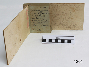
Financial record - Receipt Book, Department of Works and Mines Victoria, July 1936 (first record)
Establishment and Functions Prior to 1860, the Chief Secretary's Department had been responsible for the administration of the gold fields and associated mining activities. In November 1860 a Commissioner of Mines was appointed and a Department was established under his administration. For the period November 1861 to June 1863, the Postmaster General was responsible for the Mining Department. A Minister of Mines was again appointed in 1863. Responsibilities of the Department of Mines were: 1. Regulation of mining and related public works activities through the issue of miners rights, business and residence licences, mining leases, mineral and other prospecting licences 2. Superintendence of the activities of mining surveyors, registrars, wardens and Mining Boards. 3. Investigation of the state's geological structure, mineral wealth and underground water resources 4. Development of the mining industry 5. Supervision of the safe working of mines, machinery and quarries including checking the credential of mine managers, inspectors and operators 6. Regulation of the disposal of sludge and other waste products 7. Administration of the Victorian Mining Accident Relief Fund. Arising from its initial responsibility for the supply of water on the gold fields, the Department became responsible for rural water supply from the mid 1860s. Statutory responsibility for rural water works during this period rested with the Board of Land and Works. In 1865 the Waterworks Act gave the Board power to construct waterworks, purchase land, levy charges and lease or sell works, while the Public Loans Act 1865 empowered it to provide loans to local water trusts for waterworks. The actual administration of these statutory provisions was undertaken by the Victorian Water Supply Department which operated from 1865 to 1889 as a sub-department of the Department of Mines, from 1889 as a department in its own right, and from 1895 to 1909 as a sub-department of the Department of Mines and Water Supply. For a brief period from 1891 to 1893 the Department of Mines was also responsible for forests and, until 1880, for the Schools of Mines subsequently transferred to the Education Department. In 1895 the Department of Mines and the Victorian Water Supply Department were amalgamated to form the Department of Mines and Water Supply. A snapshot into social history around the 1930s when the Department of works and the Mines Departments were still linkedReceipt Book for the Department of Works; Mines. Receipt No 2801 - 3000. 1st receipt Number 2801, "18th July 1936, for Rent of Cottage: 14 days for 2 pounds, 2 shillings. The inscription on the back is signed by J F Condau in 13-3-33Printed on spine "GENERAL RECEIPTS / 15 / 2801 / TO 3000" Printed on each receipt 'DEPARTMENT OF / PUBLIC WORKS. / MINES." Fill in using ink pen "(DATE) 18th July 1936 / (TO) - - - shields' / BEING) Rent of / Cottage: 14 days / (TO) 17th July / @ (symbol for pound) 1-1. p. week / . (symbol for pound) 2:2:-"Inside cover there is some red pencil writing, words and figures unreadable. Handwritten on back cover "Numbers checked / and found corredt / J S Coudou (?) / 13-3-33" One some receipts "Wharfage / S.S. Koonara"flagstaff hill, warrnambool, shipwrecked coast, flagstaff hill maritime museum, maritime museum, shipwreck coast, flagstaff hill maritime village, great ocean road, department of works: mines, receipt book, rent 1936, imperial currency, living costs 1936, department of works, department of mines, j f condou, 1933, 13-3-33 -
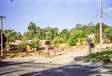
 Puffing Billy Railway
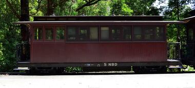
5 NBD, June 1901
NBD This is a Puffing Billy Railway reclassification of the first series of NB carriages. COMBINED NB PASSENGER CAR AND GUARD'S VAN. A saloon or end platform NB which has had a guard's compartment temporarily added in one end. Due to the temporary nature of this conversion, this vehicle also retains its original number in the NB numbering sequence but is classed NBD to differentiate it from the standard NBC and the NAC. The use of the letter 'D' in the classification is recognising the code for guard's vans prior to 1910. NB Class - Number Built (1st Series) 6 - Number Built (2nd Series) 17 - Number Built (3rd Series) 4 NB (1st series) NB 5 was equipped with a vertical hand brake at one end to enable it to be used as the last vehicle of a train. Body Length 20 feet 6 inches ( 6248 mm) Vehicle Length 25 feet 2 inches ( 7671 mm) Coupled Length 27 feet 4 inches (8330 mm) Width 6 feet 3 inches (1905 mm) Height 9 feet 5 inches (2870 mm) Weight 8 tons Capacity 16 passengers Built 1898 - 1904 Number Built 6 In use NBD 1, 2, 5 NB - Puffing Billy Railway classed these as NBD to indicate their use as a trailing vehicle with guard's accommodation. 5 NBD Victorian Railways Service History NBB 5. ( it's original number ) Built new - - / 6/1901 Newport Workshops 4/ 2/1902 - In Service "Commenced running" circa 1910 - renumbered To NB 5 *NB 5. - / 6/1926 - Modified AC Malco 5/ 2/1951 - Scrapped - Body and underframe purchased by Puffing Billy Preservation Society from Pakenham. Restored by the Puffing Billy Preservation Society 1975. In July 2006 work commenced on 5 NB to make it a temporary kitchen car for the luncheon/dinner train. It has had the seating removed from the saloon and kitchen equipment installed. Plans are for a kitchen car to be constructed and 5 NB restored to carry passengers.Historic - Victorian Railways Narrow Gauge - Passenger Rolling Stock: Passenger and Guard's Van carriage 5 NBD - converted into Catering Car and Guards vanMade of Timber and steel 5NBDvictorian railways, narrow gauge rolling stock, 5nbd - catering car and van, puffing billy -
 Melbourne Legacy
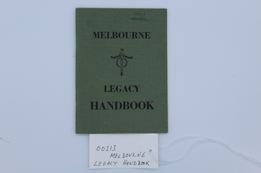
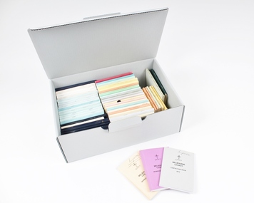
Booklet, Melbourne Legacy Handbook, 1951
A guide to help Legatees understand their responsibilities. These handbooks are updated periodically. Also known and the Contactors Handbook. A handbook is issued to all Legatees to assist them with their work with the legacy widows; eg childrens' education, welfare, accommodation, health. A quick easy guide to services provided by Melbourne Legacy such as bursaries, medical care, financial assistance etc for Legatees use. It was reissued annually for many years prior to keeping this information electronically. Many issues are held at 00002 and 00305. Chapters of the book include the following (taken from the 1956 edition), many of which are committees: Administration Anzac Day Observance Comradeship. 'Comradeship is an integral and important part of Legacy. This committee's function is primarily to arrange social and other activities which bring members together so that they become known to each other on an intimate and friendly basis; and so that when a member strikes a problem, he immediately knows with whom he might get into touch to discuss it in then spirit of mutual assistance.' Finance Huntingdale (Golf Club) Intermediate Legacy Liaison Personnel Committee Programme Committee Dealing with the Junior Legacy Committee: Boys' Group Camps and holidays Christmas party Contact Cultural and Library Dental Demonstration Education Employment Firewood Girls' Group Housing and accomodation Legal Longbank (holiday home for widows in need of a rest) Medical Newsletter Older widows Optometrists Pensions Probation Residences Special cases Welfare Appendix A Allowances for school requisites Appendix B Scholarships Appendix C Pensions / War widows pensions / Commonwealth widows pensions / Immediate assistance SCTF Appendix D Repatriation Department Appendix E Commonwealth Social Services Appendix F CWD - Children's Welfare Department Appendix G Hospital and medical benefits for Legacy Widows and their dependants Appendix H AMF Relief Trust Fund Appendix I SCTF - Services Canteen Trust Fund Appendix J Sir Samuel McCaughey Bequest Appendix K Various sources of assistance available (eg clothing, blankets, POW associations, RSL, conveyance allowances.)A helpful booklet for Legatees in carrying out their duties.Printed paperback book with olive green cover, white pages and black type. Front cover, Melbourne Legacy Handbook and Legacy logo printed in black ink, 1951 handwritten in black biro and underlined twice in green pencil. Cover and pages stapled together. Page 4, alterations handwritten in blue ink, one alteration made by hand held stamp.regulations, objectives, rules -
 Melton City Libraries
Photograph, W.Whittington Wheelwright, Unknown
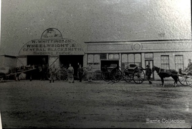
Blacksmith Shop High Street Melton Residence and Blacksmith Shop was continuously occupied from 1860 and demolished in 1966. Mr A.G. Macdonald operated the shop from 1923-1962 (39 years) An early photo exists of the Blacksmith Shop. It stood on what is now part of the landscaped area of the Melton Community Hall. The three blacksmiths wearing aprons are from the left, W. Whittington, G. Macdonald and A Falconer. MacDonald were employed by Whittington prior to each one in turn taking over the business, Falconer soon after selling the to MacDonald, died. He is buried in the Melton Cemetery. The old Smithy [on the right] stood in what is now 8 High Street Melton. The blacksmith and wheelwright was the forerunner of the modern motor mechanic, whose task it was and is, to keep the wheels of locomotion turning. According to the records there was a Blacksmith in Melton before 1850. In 1871, three blacksmiths, Messrs. A Blackwood, J MacPherson, and A Cameron were operating in Melton. In 1872 Mr. J.B. Whittington commenced as a blacksmith in Toolern Vale. On January 30th 1900, Mr Alexander Blackwood sold the property shown in the picture to J.B. Whittington where his son William Whittington conducted the business. William’s three children attended Melton State School No 340 The family left the district in 1921 when they moved to Essendon. Mr William Whittington died in 1963 at the age of 94. The next owner of the business, for a short period, was Mr. Ackland Falconer, who was succeeded by Mr A.G. Gordon MacDonald, in September 1923. Mr MacDonald raised a family of three. Thirty nine years later, in 1962, he retired, going to live with his son Robert in Sunshine, and the blacksmith shop finally closed its doors. This part of Melton’s history was demolished in by order of the Housing Commission, in 1966. Article research by Melton and District Historical Society Members. note: spelling should be Macdonald. History of the Melton Mechanics Institute. Mabel Rogers 1985 A.G. Macdonald Secretary 1927 – 1956 page 17. Committee member for 41 years. He also held the position of caretaker Blacksmith Shop, High Street Melton. The three blacksmiths wearing aprons are from the left, W. Whittington, G. Macdonald and A Falconer. local identities -
 Melton City Libraries
Photograph, Opening of the Shire Hall, c.1964
Summary of Thomas Lindsay Barrie (1914 – 1990) A life long resident of Melton Son of Jessie and Charles Ernest Barrie of Darlingsford Melton Married Marion Ferris at Christ Church Melton on 11th May 1939. They lived on the family farm at Ferris Road Melton. They had one son, Ian who has continued in farming in Melton. He served the community in the following – Shire of Melton Councillor Member for 32 years 1941 – 1970 Elected as Councillor for Melton South 1970 – 1973 Councillor for Rockbank 1943 – 1944 Shire President for three terms 1958 – 1959 ditto 1964 – 1965 ditto Council Representative: Bacchus Marsh High School and Western Suburbs Municipalities. Representative on delegation to prevent Melton post primary students being sent to Deer Park prior to the establishment of Melton High School. Melton Bush Fire Brigade 1941 Member Melton Bush Fire Brigade Registered No. 425 1942 1942 2nd Lieutenant 1943 – 1944 4th Lieutenant Country Fire Authority Rural Services Award 1963 20 Years Long Service Badge Scots Presbyterian Church Melton Member of the Board of Management 1947 – 1969 information from Annual Reports note more research needed at Uniting Church Archives to determine the earliest and last date. Tom farmed the family property with his father and brothers, and later the Ferris Road property which continued with his son Ian. His childhood interest in horses began with the draft horses kept at the bluestone stable and barn at Darlingsford. When the stables were empty in the late 1980s visit, he vividly recalled the names of the horses he had handled in his youth. When the draft horse became obsolete with the introduction of tractors and trucks this interest continued with the breeding and training of harness racers. Darlingsford Drafts and Ponies. Order of Stalls Clydesdales – Dick, Dolly, Flower, Nugget, Blossom, Lofty, Prince. Roger, Rose, Violet, Don, Beauty, Baldy, Diamond. Cart and Mounts Creamy, Digger, Popsy Compiled by Wendy Barrie 2013 Councillor Tom Barrie, Shire President and a group of children at the opening of the building.council, local identities -
 Melbourne Legacy
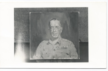
Photograph - Portrait, Lieutenant-General Sir Stanley Savige
Photograph of a painted portrait of L/- Stan Savige. The signature appears to be 'Manders '45'. He appears to be in uniform and could be from his service in World War 2. Stanley Savige is seen as the founder of Legacy when it was founded in Melbourne in September 1923. He was born in Morwell Victoria on 26/6/1890. He served in the Australian Army between 1915 and 1946, including service in both World Wars. Stanley Savige was awarded a KBE, CB, DSO, MC,ED. Stanley George Savige was born in Victoria in 1890, and enlisted in the AIF (Private 577) in March 1915. He served with 24 Battalion at Gallipoli, and was commissioned as a 2nd lieutenant prior to the evacuation, at which he was part of the final holding party at Lone Pine. In France he saw service with 6 Brigade Headquarters as well as with his battalion, and was awarded the Military Cross for his gallantry at the second battle of Bullecourt. In 1918, he became one of a small number of Australians selected for service with 'Dunsterforce' in Persia, commanding 'Urmia Force', and was awarded the Distinguished Service Order. Between the wars, Savige continued his military career with the Militia, and by 1939 he held the rank of colonel. When the 2nd AIF was raised, he was placed in command of 17 Brigade, which he led through the campaigns in Libya, Greece and Syria, before being promoted to command 3 Division (Militia) in New Guinea. In 1944, he was appointed GOC 2 Corps, in command of forces engaged in the campaign on Bougainville, and accepted the Japanese surrender there in September 1945. Lieutenant General Savige was knighted (KBE) in 1950, and died in 1954. He is widely remembered for his efforts between the wars in founding the Legacy Clubs (which he modelled on the 'Remembrance Club' formed in Hobart by his friend and former commander Sir John Gellibrand in 1923) to care for the dependants of deceased servicemen and ex-servicemen. These clubs grew into a nation wide organisation which, by the time of Savige's death, was supporting over 80 000 widows and children.This is a photographic portrait of the founder of the first Legacy Club in Australia, Sir Stanley Savige.Black and white photo of a painting of Sir Stan Savige printed onto a postcard.Stamped with 'Photograph No. MH 91859 Supplied by Military History Section (S.D.9,) General Staff L.H.Q. For official purposes ONLY, NOT TO BE PUBLISHED' in purple ink.savige, portrait, stan savige, founding legatees -
 Surrey Hills Historical Society Collection
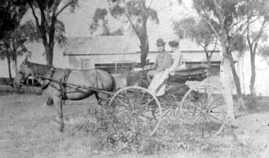
Photograph, 'Hillsboro' or "Hillsborough' - 6a Thistle Street, Surrey Hills, pre-1890
The photo was found behind a mantelpiece in the house at 6A Thistle Street while it was being renovated. It is thought to be of the first owner, Mrs Rachel Sweetnam (nee Lewis) and her husband, Thomas Edward Sweetnam. They were married on 24 September 1884 at St John's Church, Camberwell. REF: THE ARGUS 4 Oct 1884 Thomas second eldest surviving son of Matthew Sweetnam married to Rachel (Ray) third eldest daughter of Captain T.D. Lewis, Culm Haven, Camberwell. Thomas was active in land sales and variously described as a land agent, real estate agent and auctioneer. The property - Hillsboro or Hillsborough - was originally a house on a farm of 10 acres owned by her. It became 6A Thistle Street. According to the Alan Holt property register Rachel Sweetnam owned the property prior to 1890 and a family tree on Ancestry.com has that it was owned by her in c1886. It is likely that it was an investment rather than a family residence. Thomas Sweetnam was President of the Boroondara Shire 1888/89 and a councillor from 1886-1891. During his time as Shire councillor in 1887 he was charged with assaulting Charles A. Chandler, a window blind manufacturer, in response to an ‘insulting note’ left at Sweetnam’s house. Sweetnam was fined two guineas and 31 shillings. Sweetnam was also President of the Camberwell Gun Club from around 1890 – 91. In 1893 he relocated to Ferntree Gully, where he contested for the municipality’s North Riding council seat. Multiple references can be found on Trove. Note that the gentleman in this photo does bear a resemblance to Thomas Sweetman, President of Boroondara Shire in 1888-1889 found in the City of Boroondara Library Service mayoral portrait collection. No known photo of Rachel Sweetnam. Other property owners or residents are: 1890 Selina Gaylor 1900 Stephen Pullen 1910 William Murray (draftsman) 1920 George C Hughes 1930 Arthur Leslie Austin (tram driver) 1980 Mrs Lillian Evelyn Austin Sold in 1983 for $87,000. The house is still extant (January 2025). Note that we also have material / photos regarding George Hughes and family.This photo is one of the earliest photos of residences of Surrey Hills.Black and white photo of a woman and man in a buggy behind which is a simple house with a verandah at one end, surrounded by eucalypt trees.hillsboro, house names, thistle street, horse-drawn vehicle, clothing and dress, hillsborough, rachel sweetnam, rachel lewis, thomas sweetnam, selina gaylor, stephen pullen, william murray, george hughes, arthur austin, lillian austin -
 Southern Sherbrooke Historical Society Inc.
Information folder - Germans Gully - Arcady
Folder containing items pertaining to the history of Germans Gully - Arcady, Belgrave Heights. Contents: -4 colour photos, c. 2000, showing house and gardens -sketches, photocopied, by Barbara Smith, dated 29 October 2002, showing stone huts at Arcady prior to mid-1950s, with additional comments by Marian Matta -typescript, "Short History Of Arcady also known as German Gully, 'Carinya' & Church Of Freedom", 1 page, 3 copies including one with small photo -typescript, dated 22 June 97, "Plarre Visit to 'Arcady', Originally Known as 'Carinya'", six pages -hand-written letter, addressed to "Sue & Peter" (Downard) from Ralph (Wilson) dated April 02, containing historical information re. Arcady, 4 sheets double-sided -Yarra Ranges Shire Heritage Study Place Nomination Form for Germans Gully, partially completed -obituary, Herald Sun newspaper, undated but 2003, "Raymond Otto Plarre, Baker had passion for quality produce" -4 page Fairfax newspaper wraparound, "A Recipe For Success", advertising feature commemorating Ferguson Plarre Bakehouse Centenary, 1901-2001 -8 sheets of photocopied photos of Arcady, taken during Plarre ownership -Certificate Of Title (number illegible) dated 10 July 1919, initial purchasers being Robert and Bertha Maurer, 3 copies of obverse sheet (copies) (dups. in A3 folio #1) -Certificate of Title, Vol. 5262, Folio 1052392, dated 18 January 1927, initial purchaser being Bernhard Walk (2 copies, one issued 12 Aug 1996, one issued 17 Apr 1997) (dups. in A3 folio #1) -photo (colour) and hand-drawn map of site, prepared by Ralph Wilson, 2006 -Pamphlet, "Our Place, a celebration of where we live", Shire of Yarra Ranges, Oct. 2006 -photos (2, colour) of fire at Arcady, annotated 'Hello Peter & Sue, more pictures taken by Marty of CFA' -article, Australian Post, 6 Jul. 1972, 'Fool around with SCARLETT!', 2 photos of John Wilson (in A3 folio #1)albert hartung, otto plarre, mr stace, john wilson, count felix von lucknor, mr & mrs smart, plarre family, mr hutter, carinya, raymond otto plarre, ferguson plarre bakehouses, keith cooke, hugh ackland, alexander wynnum king, russell & jean smart -
 Bendigo Historical Society Inc.
Document - PETER ELLIS COLLECTION: LETTER TO PETER ELLIS
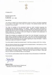
Letter written to Peter Ellis from Stephen Brady Official Secretary to the Governor-General and Secretary of the Order of Australia. Dated 4 October 2011. Honours-in-Confidence. Mr Peter Nicolaus Ellis 5 Flora Lane Flora Hill Vic 3550. Dear Mr Ellis I am writing on behalf of the Governor-General to inform you that you are being considered for the award of the Medal of the Order of Australia in the General Division within the Australian Honours System. The Order of Australia is the pre-eminent means by which Australia recognises the outstanding and meritorious service of its citizens. Awards are publicly announced on Australia Day and The Queen's Birthday. It is proposed that your award be announced in the Australia Day Honours List on Thursday 26 January 2012, and the proposed citation for the honour would be: 'For service to the arts through the collection and preservation of Australian folk history and heritage'. Please find enclosed an acceptance and privacy form and information concerning your award, which is intended for release to the media. If you wish to accept the proposed award, please complete and sign both sides of the form and return it to me in the envelope provided, together with any amendments you may suggest regarding the media information. I need to receive your reply by 22 October 2011 please. If you feel unable to accept the proposed award, I ask that you please confirm this in writing. After the Governor-General has considered all the proposed awards, I shall advise you of the outcome prior to the announcement date. Finally, I ask that you keep the contents of this letter strictly confidential until you receive confirmation of the honour, and the subsequent announcement of the award is made in the Commonwealth of Australia Gazette. In the event that you decline the award, I would ask that you maintain the confidential status of the proposal. If you have any queries please contact the Australian Honours Secretariat on 02 6283 3604. Yours sincerely Stephen Brady Official Secretary to the Governor-General and Secretary of the Order of Australia. Government House Canberra, ACT 2600 Australia telephone (02) 6283 3533 Facsimile (02) 62833620 Email [email protected] Honours-in-confidenceperson, individual, peter ellis oam -
 The Beechworth Burke Museum
Photograph - Lantern Slide, c1900
This picture shows an angle of Beechworth Primary School (State School number 1560) which is also pictured in the building's entry in the Victorian Heritage Register (VHR record 1718). The school began as a national school in 1858 as an alternative to Wesleyan and Anglican schools already operating in the area. Its name was changed to Common School number 36 in 1862 and the Beechworth Academy prior to being taken over by the Education department in 1873. The new premises were built in 1875 utilising the skills of architect Henry Bastow though the original design may be attributable to the firm Wharton and Vickers. The design was used with modifications for other schools in Victoria, including the Competition School in Errol Street, North Melbourne. The school moved to the building pictured from its original premises in Loch Street, designed by Thomas Dalziel, which later became the office of the Ovens Advertiser. The school was opened on 2 July 1875 by former Beechworth resident G.B. Kerferd, who was then the Premier of Victoria. The image shows approximately ninety older students at the school in approximately 1900. There are approximately equal numbers of boys and girls pictured, with most of the individuals pictured appearing to be between the ages of twelve and fifteen. Although the school had more than 1000 students enrolled at its height, enrolments had declined to 304 in 1890. Also visible is a fringe of sequoia pines which were planted by the school children as a project lasting through to the late 1930s. Lantern slides, sometimes called 'magic lantern' slides, are glass plates on which an image has been secured for the purpose of projection. Glass slides were etched or hand-painted for this purpose from the Eighteenth Century but the process became more popular and accessible to the public with the development of photographic-emulsion slides used with a 'Magic Lantern' device in the mid-Nineteenth Century. Photographic lantern slides comprise a double-negative emulsion layer (forming a positive image) between thin glass plates that are bound together. A number of processes existed to form and bind the emulsion layer to the base plate, including the albumen, wet plate collodion, gelatine dry plate and woodburytype techniques. Lantern slides and magic lantern technologies are seen as foundational precursors to the development of modern photography and film-making techniques.The image is significant because it sheds light on the educational infrastructure present in Beechworth in the early part of the Twentieth Century, including the prevalence of education for students after current-day primary-school age and the education of girls. It also provides insight into the building and design practices used by Government departments at the time. Thin translucent sheet of glass with a circular image printed on the front and framed in a black backing. It is held together by metals strips to secure the edges of the slide.Obverse: L / burke museum, beechworth, lantern slide, slide, glass slide, plate, burke museum collection, photograph, monochrome, schools, education, high school, primary school, common school, state school, state school 1560, common school 36, beechworth academy, g.b. kerferd, thomas dalziel, henry bastow, victorian heritage register, beechworth primary school, girls education, boys education, public schools, education department, pines, trees, sequoias, competition school -
 Eltham District Historical Society Inc
Photograph, Fay Bridge, Clifton Pugh's Artists' Colony, Dunmoochin, Barreenong Road, Cottles Bridge, c.1995
Visit to Dunmoochin prior to Clifton Pugh's home being destroyed by fire in 2002. Following military service in the second world war, Clifton Pugh studied under artist Sir William Dargie at the National Gallery School in Melbourne as well as Justus Jorgensen, founder of Montsalvat. For a while he lived on the dole but also worked packing eggs for the Belot family saving sufficient to purchase six acres (2.4 ha) of land at Barreenong Road, Cottles Bridge. He accumulated more land and persuaded several other artists and friends to buy land nearby, resulting in a property of approximately 200 acres, stablishing it as one of the first artistic communes in Australia alongside Montsalvat in Eltham. It was around 1951 that Pugh felt he had '"done moochin' around" and so the name of the property evolved. He bought timber from Alistair Knox to build his house on the crest of a hill. Inspired by local goldminer's huts, it was a one room wattle-and-daub structure with dirt floor. Over the years it expanded with thick adobe walls made from local clay, high ceilings and stone floors. All materials other than the local earth were sourced from second hand materials, most found at wreckers' yards. Artists from across the nation were drawn to Dunmoochin, with several setting up houses and shacks on the property, maintaining their independence but sharing their artistic zeal. Artists who worked or resided at Dunmoochin included Mirka Mora, John Perceval, Albert Tucker, Fred Williams, Charles Blackman, Arthur Boyd and John Olsen. In 2002, Pugh's house along with its treasure trove of art and a library of some 20,000 books was destroyed by fire. Traces of Pugh's home remain with the presence of the Victorian doorframe archway with leadlight of intricate design, procured from a demolished Melbourne mansion; and two bronze life-sized female statues created by Pugh and cast by Matcham Skipper. In place of Pugh's house rose two double-storey mud-brick artists' studios topped with corrugated iron rooves curved like the wings of a bird with accommodation for seven. The original studios, gallery and other buildings survived the fire.fay bridge collection, 1995, barreenong road, cottles bridge, dunmoochin -
 Eltham District Historical Society Inc
Photograph, Clearing land for Le Pine Funeral Home, cnr York Street and Main Road, Eltham, c.March 1998, 1998
Newsletter No. 116, September, 1997 846-848 MAIN ROAD ELTHAM Nillumbik Shire Council has granted a permit for a funeral parlour on land which includes this site at the corner of Main Road and York Street. The site contains an architect's office in a building which was formerly a shop and dwelling dating from the 1920's. The proposal requires demolition of this building which is one of the few remaining old shops which formed the rather spread out "town centre" of Eltham. Prior to making its decision the Council obtained a report from Graeme Butler and Associates, the heritage consultants who carried out Stage 1 of the Nillumbik Heritage Study. The report summarized the historical significance as follows:- "This brick comer shop with associated residence has potential local historical significance as a late 1920's grocer's shop, now much altered and one of only a few shops of that era left in Eltham's Main Road. This significance is qualified by the many changes. The other examples are better preserved and still function as shops." With this type of expert advice it is difficult to make a strong case for preservation of the building although, of course, it is a shame to see it demolished. The report includes details of the site itself and its history based on research carried out by Carlotta Kellaway. The building dates from the late 1920's when it was owned by C.R. Nicholls. From the early 1930's it was Charles Cockroft's grocery shop and he also ran a grain store there. According to his daughter, Edna Brown, he delivered groceries around the district taking his truck as far as Kangaroo Ground. In 1950 he shifted to Traralgon. Since then several different businesses have operated from the site including a bottle merchant and produce store. Conversion to the present office use involved alterations to the shop front and rebuilding the galvanized iron store at the rear. Newsletter 119 March 1998 In our Newsletter No. 116 it was reported that the former shop on the comer of Main Road and York Street, Eltham was to be demolished as part of a funeral parlour development. If you have passed the site recently you will have noticed that it has now been demolished - another part of the old Eltham township has disappeared.Roll of 35mm colour negative film, 6 strips Also photographic prints 10 x 15 cmKodak Gold 200-6a.r. warren, eltham feed store, le pine funeral home, main road, york street, c.r. nicholls, charles cockcroft, grocery store -
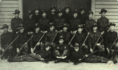 Federation University Historical Collection
Photograph - Photograph - black and white, Ballarat Junior Technical School Cadet Team, 1916, 1916
Francis Davis was the only former student of the Ballarat Junior Technical School to die during World War One. "Francis Davis was accorded a full military funeral, firing party, bugler and pallbearers. The coffin was draped in the Union Jack and surmounted in several beautiful wreathes sent from his brother 2/A.M. E.H. Davis (A.F.C Leighterton), officer of the A.F.C. Leighterton, Gloucester, Cadets of A.F.C. and many other personal friends of the deceased. The "Last Post" was sounded at the graveside, and the Rev. Major K.D. Norman C. of E. A.I.F. officiated. The grave was to be turfed and an oak cross erected by the A.I.F. London. Administrative Headquarters A.I.F. London were represented at the funeral. (http://naa12.naa.gov.au/scripts/Imagine.asp?B=1858392, accessed 24 January 2014.) According to Neil Leckie, Manager of the Ballarat Ranger Military Museum: * Originally 12 – 14 year olds went to Junior Cadets attached to their school. * From age 14 – 17 they were Senior Cadets attached to the local militia unit. * After 1 July of the year a Cadet turned 18, the Cadet left the Senior Cadets and became a member of the Citizen Military Force. * In October 1918 the AIF, Militia and Cadets were renamed to give some connection to the AIF battalion raised in the area. Ballarat saw: 8th Australian Infantry Regiment comprising: * 8th Battalion AIF renamed 1st Battalion 8th Australian Infantry Regiment * 70th Infantry Militia renamed 2nd Battalion 8th Australian Infantry Regiment * 70th Infantry Cadets renamed 3rd B, 8th Australian Infantry. 39th Australian Infantry Regiment comprising: * 39th Battalion AIF renamed 1st Battalion 39th Australian Regiment * 71st Infantry Militia renamed 2nd Bn, 39th Australian Infantry Regiment * 71st Infantry Cadets renamed 3rd Bn, 39th Australian Infantry Regiment Prior to the reorganisation in 1918 the 18th Brigade was the 70th, 71st and 73rd Infantry. It is thought that the 18th Brigade Cadet units in 1920 were those that came from the old: * 69th Infantry (Geelong/Queenscliff) * 70th Infantry (Ballarat/Colac) * 71st Infantry (Ballarat West) * 72nd Infantry Warrnambool) * 73rd Infantry (NW Vic) The next name change came in 1921!Black and white photograph of a group of school boys in army uniform. They are members of the Ballarat Junior Technical School Cadets. Back Row: D.O. Taylor, Albert E. Williams, B. Burrows, J.B. Hobba Standing: Francis Davis, Miller, A. Burge, P. [Peter] Chatham. J. Minster, H. Witter, H. Siemering Kneeling: T.G. Wasley, Alan Riley, A.H. Hoskin. N.C. Carmichael, Harold G. Wakeling, T. Rees, W.H. Shattock, F.N. Gibbs Front: S.J. Chambers, F.J. Procter, Charles H. Beanland francis davis, frank davis, ballarat junior technical school cadets, cadets, d.o. taylor, albert e. williams, b. burrows, j.b. hobba, miller, a. burge, p. chatham, j. minster, h. witter, h. siemering, t.g. wasley, a. riley, a.h. hoskin, n.c. carmichael, harold wakeling, t. rees, w.h. shattock, f.n. gibbs, s.j. chambers, f.j. procter, charles h. beanland, alan riley -
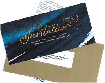 Federation University Historical Collection
Invitation, Invitation to Attend a Luncheon with HRH Prince Edward at Federation University Mt Helen Campus, 2018, 2018
Federation University Australia showcased its students and research at a luncheon for His Royal Highness The Prince Edward, Earl of Wessex KG GCVO, at the Mt Helen Campus on Sunday, 8 April. The University’s student leaders and academics joined other dignitaries and business representatives for the special event. “The University is deeply honoured to host HRH The Earl of Wessex and share his passion for volunteerism and The Duke of Edinburgh’s International Award,” Professor Helen Bartlett, Vice-Chancellor, said. Prior to the luncheon HRH The Earl of Wessex experienced a Welcome to Country and Smoking Ceremony at the University. The program included showing HRH The Earl of Wessex concept plans for a refurbished Sports Science facility at the Mt Helen Campus. Guests were treated to a performance by the Arts Academy’s renowned vocal ensemble Word of Mouth. At the conclusion of the luncheon, HRH The Earl of Wessex planted a tree at the Student Commons Courtyard. The visit to the University by HRH The Earl of Wessex was the first by a member of the Royal Family since Prince Charles visited in 1974. HRH The Earl of Wessex was in Australia to attend the Commonwealth Games and undertake additional engagements to recognise and promote The Duke of Edinburgh’s International Award in Australia. HRH The Earl of Wessex, who is the Chair of The Board of Trustees of The Duke of Edinburgh’s International Award Foundation, attended 32 engagements across Melbourne, Ballarat, Hobart, Brisbane, and Adelaide, from formal receptions, Award presentations, meetings with government officials and the community sector, to meeting Award Participants and their families at community centres. The events enabled HRH The Earl of Wessex to engage with over 1,000 young people undertaking the Award, and over 3,400 Award volunteers and supporters who will have the opportunity to discuss their activities and showcase the work being done to help young Australians dream big, challenge themselves and find their purpose, passion and place in the world. HRH The Earl of Wessex’s visit celebrates significant milestones and growth in the diversity of The Duke of Edinburgh’s International Award program in Australia. “The Award’s relevance to all young Australians is as important today as it was when it started over 60 years ago,” Mr Peter Kaye AM, Chief Executive Officer of The Duke of Edinburgh’s International Award – Australia, said. “Employers in particular are recognising the ‘soft skills’ that are so necessary for a well prepared future employee.”Invitation and dress code in a gold envelope. Addressed "Ms Clare Gervasoni Curator, Art & Historical Colelctions Federation University Australia Mt Helen Campus"prince edward, earl of wessex, helen bartlett, visitors, royal visit -
 Federation University Historical Collection
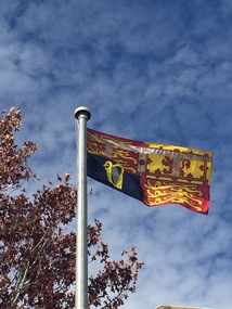
Photograph - Photograph - Colour, Suzanne Godfrey, The Royal Standard Flying at Federation University Mt Helen Campus, 2018, 09/04/2018
Federation University Australia showcased its students and research at a luncheon for His Royal Highness The Prince Edward, Earl of Wessex KG GCVO, at the Mt Helen Campus on Sunday, 8 April. The University’s student leaders and academics joined other dignitaries and business representatives for the special event. “The University is deeply honoured to host HRH The Earl of Wessex and share his passion for volunteerism and The Duke of Edinburgh’s International Award,” Professor Helen Bartlett, Vice-Chancellor, said. Prior to the luncheon HRH The Earl of Wessex experienced a Welcome to Country and Smoking Ceremony at the University. The program included showing HRH The Earl of Wessex concept plans for a refurbished Sports Science facility at the Mt Helen Campus. Guests were treated to a performance by the Arts Academy’s renowned vocal ensemble Word of Mouth. At the conclusion of the luncheon, HRH The Earl of Wessex planted a tree at the Student Commons Courtyard. The visit to the University by HRH The Earl of Wessex was the first by a member of the Royal Family since Prince Charles visited in 1974. HRH The Earl of Wessex was in Australia to attend the Commonwealth Games and undertake additional engagements to recognise and promote The Duke of Edinburgh’s International Award in Australia. HRH The Earl of Wessex, who is the Chair of The Board of Trustees of The Duke of Edinburgh’s International Award Foundation, attended 32 engagements across Melbourne, Ballarat, Hobart, Brisbane, and Adelaide, from formal receptions, Award presentations, meetings with government officials and the community sector, to meeting Award Participants and their families at community centres. The events enabled HRH The Earl of Wessex to engage with over 1,000 young people undertaking the Award, and over 3,400 Award volunteers and supporters who will have the opportunity to discuss their activities and showcase the work being done to help young Australians dream big, challenge themselves and find their purpose, passion and place in the world. HRH The Earl of Wessex’s visit celebrates significant milestones and growth in the diversity of The Duke of Edinburgh’s International Award program in Australia. “The Award’s relevance to all young Australians is as important today as it was when it started over 60 years ago,” Mr Peter Kaye AM, Chief Executive Officer of The Duke of Edinburgh’s International Award – Australia, said. “Employers in particular are recognising the ‘soft skills’ that are so necessary for a well prepared future employee.”Photograph of the Royal Standard Flying on the Federation University Mt Helen Campus flagpoles during the visit of HRH the Prince Edward, Earl of Wessex, KG GCVO. Prince Edward visited the Mount Helen campus as the Chair of the trustees of The Duke of Edinburgh's International Award Foundation. The award is the world's leading youth achievement award. It has helped inspired, empower, connect and recognise the achievements of more than 8 million young people in more than 140 countries. The Award presents a balanced, non-competititive program of voluntary activites that encourage personal discovery, growth, resilience, perseverance, responsibility and community service. It is about individual challenge and encouraging young people to become mature and active citizens who positively contribute to society, through activities that inspire them.prince edward, earl of wessex, royal visitor, duke of edinburgh's international award foundation, federation university, royalty -
 Federation University Historical Collection
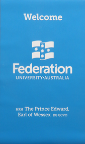
Poster, Federation University Australia Welcome to HRH Prince Edward, 2018, 09/04/2018
Federation University Australia showcased its students and research at a luncheon for His Royal Highness The Prince Edward, Earl of Wessex KG GCVO, at the Mt Helen Campus on Sunday, 8 April. The University’s student leaders and academics joined other dignitaries and business representatives for the special event. “The University is deeply honoured to host HRH The Earl of Wessex and share his passion for volunteerism and The Duke of Edinburgh’s International Award,” Professor Helen Bartlett, Vice-Chancellor, said. Prior to the luncheon HRH The Earl of Wessex experienced a Welcome to Country and Smoking Ceremony at the University. The program included showing HRH The Earl of Wessex concept plans for a refurbished Sports Science facility at the Mt Helen Campus. Guests were treated to a performance by the Arts Academy’s renowned vocal ensemble Word of Mouth. At the conclusion of the luncheon, HRH The Earl of Wessex planted a tree at the Student Commons Courtyard. The visit to the University by HRH The Earl of Wessex was the first by a member of the Royal Family since Prince Charles visited in 1974. HRH The Earl of Wessex was in Australia to attend the Commonwealth Games and undertake additional engagements to recognise and promote The Duke of Edinburgh’s International Award in Australia. HRH The Earl of Wessex, who is the Chair of The Board of Trustees of The Duke of Edinburgh’s International Award Foundation, attended 32 engagements across Melbourne, Ballarat, Hobart, Brisbane, and Adelaide, from formal receptions, Award presentations, meetings with government officials and the community sector, to meeting Award Participants and their families at community centres. The events enabled HRH The Earl of Wessex to engage with over 1,000 young people undertaking the Award, and over 3,400 Award volunteers and supporters who will have the opportunity to discuss their activities and showcase the work being done to help young Australians dream big, challenge themselves and find their purpose, passion and place in the world. HRH The Earl of Wessex’s visit celebrates significant milestones and growth in the diversity of The Duke of Edinburgh’s International Award program in Australia. “The Award’s relevance to all young Australians is as important today as it was when it started over 60 years ago,” Mr Peter Kaye AM, Chief Executive Officer of The Duke of Edinburgh’s International Award – Australia, said. “Employers in particular are recognising the ‘soft skills’ that are so necessary for a well prepared future employee.”Blue Federation University poster created to welcome HRH Prince Edward to the Mount Helen Campus poster, banner, prince edward, royal visitor -
 Federation University Historical Collection
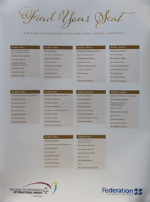
Photograph - Colour, Clare Gervasoni, Federation University Seating Arrangement for lunch with HRH Prince Edward, 2018, 09/04/2018
Federation University Australia showcased its students and research at a luncheon for His Royal Highness The Prince Edward, Earl of Wessex KG GCVO, at the Mt Helen Campus on Sunday, 8 April. The University’s student leaders and academics joined other dignitaries and business representatives for the special event. “The University is deeply honoured to host HRH The Earl of Wessex and share his passion for volunteerism and The Duke of Edinburgh’s International Award,” Professor Helen Bartlett, Vice-Chancellor, said. Prior to the luncheon HRH The Earl of Wessex experienced a Welcome to Country and Smoking Ceremony at the University. The program included showing HRH The Earl of Wessex concept plans for a refurbished Sports Science facility at the Mt Helen Campus. Guests were treated to a performance by the Arts Academy’s renowned vocal ensemble Word of Mouth. At the conclusion of the luncheon, HRH The Earl of Wessex planted a tree at the Student Commons Courtyard. The visit to the University by HRH The Earl of Wessex was the first by a member of the Royal Family since Prince Charles visited in 1974. HRH The Earl of Wessex was in Australia to attend the Commonwealth Games and undertake additional engagements to recognise and promote The Duke of Edinburgh’s International Award in Australia. HRH The Earl of Wessex, who is the Chair of The Board of Trustees of The Duke of Edinburgh’s International Award Foundation, attended 32 engagements across Melbourne, Ballarat, Hobart, Brisbane, and Adelaide, from formal receptions, Award presentations, meetings with government officials and the community sector, to meeting Award Participants and their families at community centres. The events enabled HRH The Earl of Wessex to engage with over 1,000 young people undertaking the Award, and over 3,400 Award volunteers and supporters who will have the opportunity to discuss their activities and showcase the work being done to help young Australians dream big, challenge themselves and find their purpose, passion and place in the world. HRH The Earl of Wessex’s visit celebrates significant milestones and growth in the diversity of The Duke of Edinburgh’s International Award program in Australia. “The Award’s relevance to all young Australians is as important today as it was when it started over 60 years ago,” Mr Peter Kaye AM, Chief Executive Officer of The Duke of Edinburgh’s International Award – Australia, said. “Employers in particular are recognising the ‘soft skills’ that are so necessary for a well prepared future employee.”Photograph of the seating arrangements for the dinner with HRH Prince Edward at Federation University Mount Helen Campus poster, prince edward, royal visitor, seating arrangement -
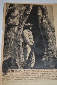
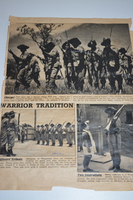 Wangaratta RSL Sub Branch
Newspaper - Newspaper Articles, 1940
Article One - Charge! - image of members of the aboriginal group carrying out a baton charge Article Two - Officer's Tribute - image of aborigines at Wangaratta carry out ceremony of changing of the guard Article Three - Two Australians - image of Shirley Anderson, 8, of Wangaratta frequently entertains Diggers, singing and dancing. She visits camp nearly every day to chat with guard on duty. Aboriginal soldiers formed a special all volunteer platoon at No 9 Camp Wangaratta in Victoria from late 1940 until February 1941. No 9 Camp was set up at the Wangaratta Showgrounds to allow the formation of the 2/24th Australian Infantry Battalion prior to leaving for Egypt. Major Joseph Albert Wright a WW1 Light Horse veteran was in charge of this platoon the only Aboriginal squad in the Australian Military Forces at that time. The soldiers from Lake Tyers enlisted at Caulfield between June and July 1940 include Harold Cornelius HAYES VX 48217 DOB 2/4/1916 Enlisted 25/7/40 Discharged 22/3/1941 Edward FOSTER VX48218 DOB 25/5/1921 Enlisted 25/7/1940 Discharged 22/3/1941 Noel Ernest HOOD VX48194 DOB 3/1/1919 Enlisted 25/7/1940 Discharged 22/3/1941 Edward Leslie MULLETT VX48199 DOB 30/6/1910 Enlisted 25/7/1940 Discharged 22/3/1941 Samuel Richard RANKIN VX48201 DOB 23/7/1910 Enlisted 25/7/1940 Discharged 22/3/1941 Stewart HOOD VX47351 DOB 23/1/1903 Enlisted 18/7/1940 Discharged 22/3/1941 William GORRIE VX48208 DOB 22/11/1921 Enlisted 25/7/1940 Discharged 22/3/1941 David John MULLETT VX48195 DOB 10/6/1919 Enlisted 25/7/1940 Discharged 22/3/1941 Arthur Alexander (Tom?) MULLETT VX48198 DOB 25/11/1914 Enlisted 25/7/1940 Discharged 22/3/1941 Images relates to the "special platoon" based at No 9 Camp Wangaratta as being the Australian Army's first all Aboriginal Unit formed in 1940. The soldiers were all volunteers mainly from Lake Tyers in Victoria. In addition to normal army training they performed guard duty at the Army Hospital and Camp. They formed the Gum Leaf Band and led the troops at community singing and assisted in Methodist Church services. Three black and white newspaper articles adhered to cream paperWarrior Tradition Written in blue ink 28/12/1940no 9 camp wangaratta, aboriginal platoon -
 Melbourne Legacy
Booklet - Document, set of handbooks, Melbourne Legacy Diary / Contactors Book, 1966-2014
The Melbourne Legacy Diary/Contactor handbooks were produced annually by Melbourne Legacy. The books supply Legatees with many useful details and regulations. They include lists of current Legatees and contact details. A handbook is issued to all Legatees to assist them with their work with the legacy widows; eg childrens' education, welfare, accommodation, health. A quick easy guide to services provided by Melbourne Legacy such as bursaries, medical care, financial assistance etc for Legatees use. It was reissued annually for many years prior to keeping this information electronically. Many issues are held at 00305. Chapters of the book might include the following (taken from the 1956 edition), many of which are Legacy committees: Administration Anzac Day Observance Comradeship. 'Comradeship is an integral and important part of Legacy. This committee's function is primarily to arrange social and other activities which bring members together so that they become known to each other on an intimate and friendly basis; and so that when a member strikes a problem, he immediately knows with whom he might get into touch to discuss it in then spirit of mutual assistance.' Finance Huntingdale (Golf Club) Intermediate Legacy Liaison Personnel Committee Programme Committee Dealing with the Junior Legacy Committee: Boys' Group Camps and holidays Christmas party Contact Cultural and Library Dental Demonstration Education Employment Firewood Girls' Group Housing and accomodation Legal Longbank (holiday home for widows in need of a rest) Medical Newsletter Older widows Optometrists Pensions Probation Residences Special cases Welfare Appendix A Allowances for school requisites Appendix B Scholarships Appendix C Pensions / War widows pensions / Commonwealth widows pensions / Immediate assistance SCTF Appendix D Repatriation Department Appendix E Commonwealth Social Services Appendix F CWD - Children's Welfare Department Appendix G Hospital and medical benefits for Legacy Widows and their dependants Appendix H AMF Relief Trust Fund Appendix I SCTF - Services Canteen Trust Fund Appendix J Sir Samuel McCaughey Bequest Appendix K Various sources of assistance available (eg clothing, blankets, POW associations, RSL, conveyance allowances.)A record of Legacy compiling information for use by the Legatees in their work with widows and junior legatees.62 small books of various colours, and some covered in black plastic. Issues from between 1966 and 2014.regulations, objectives, rules -
Moorabbin Air Museum
Document (Item) - (SP) CAC History Correspondence between CAC and the British Aviation Group 1935 to 1937
This correspondence relates to Australia possibly buying aircraft from Britain prior to WW2. CAC had decided to build the NA 16 and there was correspondence from Hawker Siddeley expressing their wish to negotiate on future aircraft CAC may manufacture Letter to B Lewis 14/1/1937 from Secretary re Hawker Siddeley Letter from Brian Lewis to Secretary CAC 11/1/1937 enclosing letter from Hawker Siddeley Letter from Brian Lewis to Essington Lewis, CAC 27/2/1937 Letter from Essington Lewis to Secretary CAC 1/3/1937 Letter from Secretary CAC to Brian Lewis 30/11/1937 Letter from Brian Lewis to Essington Lewis CAC 24/11/1937 Letter from Essington Lewis to Brian Lewis 1/3/1937 Letter from Hawker Siddeley Aircraft Company Limited to Secretary CAC 16/12/1936 Letter from Secretary CAC to Brian Lewis Memorandum for CAC Board re Hawker Siddeley proposals advising not to accept any of the proposals made - instead mentioning Bristol and de Havilland 17/11/1936 Letter from Brian Lewis to Essington Lewis 6/11/1936 Letter from Brian Lewis representing Hawker Siddeley to Essington Lewis 21/10/1936 Letter from Brian Lewis to Essington Lewis 27/6/1936 representing Hawker Siddeley anticipating the return of Wackett from his overseas trip and the setting up of the aircraft industry in Australia Letter from Brian lewis to Essington Lewis 28/3/1936 re passing over of Hawker Siddeley proposals to Mr Parkhill in Canberra Memorandum of interview with Brian Lewis and Essington Lewis and FM Mitchel of the syndicate. 19/3/1936 Proposals for co-operation in Australia by Hawker Siddeley (group consists of Hawker, glister, Armstrong whit worth, Armstrong Siddeley, Burlington carriage and A V Roe Letter from Brian Lewis to Essington Lewis providing his background and relationship with Hawker Siddeley 3/2 1936 and 17/12/1935 and 26/12/1935 Very relevant to how the aircraft industry was set up in Australia -
 Wodonga & District Historical Society Inc
Photograph - Hut 97 Bonegilla Migrant Experience
Bonegilla Army Base and Migrant Reception Centre began when funds were allocated to build Bonegilla Army Camp in June 1940. Builders began to erect about 600 huts prior to the Army moving in during September of that year. Between 1942 - 1943 it was enlarged to 848 buildings. In 1947 Bonegilla Reception and Training Centre began operating with the Army providing transport, security and catering services. From 1949 until 1965 the Bonegilla Reception and Training Centre operated without a military presence. Bonegilla Migrant Reception and Training Centre was made up of 24 blocks. It had its own churches, banks, sporting fields, cinema, hospital, police station and railway platform. It became the largest and longest operating reception centre in the post-war era. More than 300,000 migrants passed through its doors between 1947 and 1971, with most of those originating from non-English speaking European countries. From1965 with the increased Australian commitment to the Vietnam War and the need to find accommodation to train National Servicemen for Vietnam, the Army negotiated with the Department of Immigration to take over several blocks at Bonegilla. In 1971 the Reception Centre closed and the site reverted to the Army. After 1971 the Army undertook a major site redevelopment with the construction of Latchford Barracks as the Army Apprentice School. Later Latchford Barracks was redeveloped into part of the Army Logistic Training Centre. Between 1978 and 1982, nearly all of the centre was demolished in a major redevelopment. The new replacement buildings were formally opened as Latchford Barracks in 1983. Demolition of the buildings prompted calls for recognition of the site and the role it had played in Australia’s post-World War II Immigration program. After much discussion between the Department of Army and Heritage and local groups about the significance of the site, the Australian Heritage Commission proceeded with its listing on the Register of the National Estate. A Conservation Management Plan was prepared for Block 19 in 1996. The Army transferred Block 19 to the Victorian Government. In 2002 Heritage Victoria listed Block 19 on the State Heritage Register, giving attention to both the migrant and army connections with the site. Hut 97 at Bonegilla Migrant Experience is the home of the Wodonga & District Historical Society Inc.This image is significant because it records a building which is part of the Bonegilla Migrant Reception Centre which played a critical role as the largest and longest operating Migrant Reception Centre in Australia.A colour photo of Hut 97 at Block 19, Bonegilla Migrant Experience, now the home of Wodonga & District Historical Society Inc.hut 97 bonegilla migrant experience, wodonga & district historical society, immigration australia -
 Stawell Historical Society Inc
Photograph, Pioneer Walk Murals
27 colour photographs of the Pioneer Walk Mural displayed in Town Hall in 16.04.1992 prior to being installed in the "Pioneers Walk". Photos 322 - 12 to 14 shows the Pioneers walk way before a roof was placed over the walk way. The mural has been replaced. 322 Opening in Town Hall 16.04.1992, Wayne Kayler Thompson Mayor Cr. Bob Stone & Mrs Stone. 1. Opening speeches in Town Hall. Shire Councillor Laurie Delahunty & Marjory Delahunty. 2. Unveiling by project coordinator Jenny Munro. 3. First opening Town Hall 16.04.1992. This section of Mural was above entrance to Main Street. 4. First opening Town Hall 16.04.1992. 5. Another detail mural taken at Town Hall opening. 6. Mural detail 16.04.1992. 7. Photo of Bill Walker on left featured in Mural. 8. Opening in Town Hall. Mark Dadswell Times news Photographer. Herb Skurrie is featured in Mural & Helen Leach. 9. First opening, putting away at Town Hall. 10. Opening Town Hall 16.04.1992. 11. Detail of mural at opening 16.04.1992. 12. Another detail of boulders and steps in mural. Opening Town Hall. 13. Mural detail. 14. Mural on brick wall with Cate Whitehead, Jenny Munro and Peter Whitemead. 15. Mural detail opening Town Hall 16.04.1992. 16. Mural detail showing town hall drawing at first opening in Town Hall 16.04.1992. 17. Mural detail. 18. Detail in Mural at Town Hall opening 16.04.1992. 19. Edge of mural detail at Town Hall opening. 20. Lower detail of 322 (19) mural in Town Hall. 21. Mural detail Dedicated to the Pioneers of Stawell and Districts. Town Hall opening. 22. Mural detail displayed at Town Hall opening 16.04.1992. 23. Mural detail showing domestic scene and map of Stawell area at Town Hall opening. 24. Mural detail 1st opening at Town Hall. 25. Scene on mural show at 1st opening at Town Hall. 26. Photo showing one end of mural at 1st opening at Town Hall. 26 colour photographs of the pioneer walk "Murals"stawell -
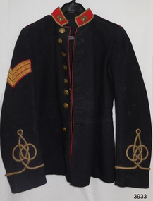 Flagstaff Hill Maritime Museum and Village
Uniform - Tunic, 1899-1903
This original tunic or jacket is part of the full dress uniform of the pre-Federation Victorian Permanent Artillery regiment. Its owner had the rank of Sergeant, as indicated by the three inverted chevrons. The Artillery design of the badges and buttons indicate the date of the tunic to be from 1893 to 1903. However the maker of the tunic, W. Moncton, began manufacture in Melbourne in 1899, so this the tunic can be dated between 1899 and 1903. The donor's grandfather was given this tunic but not the name of the original owner. It has since been suggested to the family that the tunic was worn by a local Western District Light Horse member. This could very well have been the case because mounted troops were officially referred to as the Light Horse in the late 19th to early 20th century. Several local men were involved in the Light Horse during the First World War. The donor's grandfather wore this tunic in the local district when riding a penny farthing bicycle. The donor's father also wore the tunic when dressed as a 'Captain' hosting a local disco dance. BRIEF MILITARY HISTORY- The Crimean War began In 1854 and many people in colonial Australia were afraid of a Russian attack. Volunteer forces were established to strengthen the British Imperial troops posted here. A battery of artillery was raised in Victoria as well as in other Australian states. In 1870 Australia became responsible for its own naval and military defence. The Volunteer Corps and Victorian Navy shared the responsibility of defending the existing forts, assisted by volunteer coastal and mobile field batteries. The Permanent Victorian Artillery force was established. It was disbanded in 1880 then re-formed in 1882 as the Victorian Garrison Artillery Corps. In 1895 the Geelong, Warrnambool, Port Fairy and Portland Batteries became part of the Western District Garrison Artillery. Many of the volunteers who served in the Artillery were from rural areas. They belonged to rifle clubs and were experience horsemen as well. Australia's defence at this time relied on these mounted troops, or Light Horse men. In 1899 the Victorian Garrison Artillery Corps amalgamated with the New South Wales and Queensland Permanent Artillery to become the Victorian Regiment of the Royal Australian Artillery (RAA). Then prior to Federation, the RAA and the Permanent Artillery of South Australia, Western Australia and Tasmania all combined, becoming the Royal Australian Artillery Regiment with two Batteries of Field Artillery; Battery A from Sydney and Battery B from Melbourne.This original uniform tunic of the pre-Federation Victorian Permanent Artillery is significant for its association with Australia's military defence and the fortifications of our district, state and country. The tunic is also significant, representing part of the history and evolution of uniforms in the Australian military forces. The tunic is also significant in its representation of Australia's independence in forming its own defences. The tunic has local significance in its connection with local social events.Tunic or jacket, part of the full dress uniform of the pre-Federation Victorian Permanent Artillery operating from 1893 to 1903. Original, single-breasted tunic of dark blue wool, red piping trim, black cotton lining in body. Sleeves lined with blue striped, white cotton. Front closure has eight brass buttons. Red band-style collar with hook-and-eye closure has gold bullion braid trim and a brass badge pinned each side at the front. Upper right sleeve has three inverted chevrons on red fabric with gold bullion braid trim (rank of Sergeant). Both sleeves have gold bullion braid 'Austrian knot' emblems stitched onto lower arm, with ends finishing on the inner sleeve. Shoulder epaulettes have red piping and smaller brass buttons. Closed back vent has vertical scalloped design with six brass buttons, in two columns of three, and red piping trim. Brass belt hook is attached to the left back waist, close to the seam (right side has a mark indicating a previous similar clip). Inside left breast is a concealed pocket. Tunic has both machine and hand stitching. All brass shank-style buttons have matching Artillery emblems with inscriptions on the back. The two brass collar badges have additional artillery emblems of exploding grenade and star as well as an inscription. Buttons were made for W. Moncton, of Melbourne and marked with his name. He traded from 1899, dating the tunic to between 1899 and 1903.Button front: Artillery emblem on front (field cannon facing left, in front of a muzzle-loading ram rod). Button back: engraved "W. MONCTON . MELBOURNE ." Collar badges: Artillery emblem (field cannon facing right | stars | exploding grenade | "AUSTRALIA")flagstaff hill, warrnambool, shipwrecked coast, flagstaff hill maritime museum, maritime museum, shipwreck coast, flagstaff hill maritime village, great ocean road, uniform jacket, uniform tunic, garrison volunteer uniform, fortifications in victoria, victorian permanent artillery, pre-federation military uniform, sergeant's uniform, jacket, militia, victoria, victorian volunteer forces, victorian regiment, royal australian artillery, raa, field gun, sergeant, w. moncton, garrison, dress uniform, tunic, scarlet collar, red collar, scarlet piping, red piping, gold bullion, artillery emblem, light horse, artillery, mounted troops, victorian garrison artillery corps -
 Melton City Libraries
Photograph, Tom and May Barrie, 1935
Ferris Road–Ferris Lane family farm of John and Elizabeth Ferris until 1939, until daughter Marion married Thomas Linsday Barrie. Marion Elizabeth nee Ferris born 29th of August 1914 -died 5th of June 1990 SUMMARY - Thomas Lindsay Barrie 1914 – 1990 A life long resident of Melton Son of Jessie and Charles Ernest Barrie of Darlingsford Melton Married Marion Ferris at Christ Church Melton on 11th May 1939. They lived on the family farm at Ferris Road Melton. They had one son, Ian who has continued in farming in Melton. He served the community in the following – Shire of Melton Councillor Member for 32 years 1941 – 1970 Elected as Councillor for Melton South 1970 – 1973 Councillor for Rockbank 1943 – 1944 Shire President for three terms 1958 – 1959 ditto 1964 – 1965 ditto Council Representative: Bacchus Marsh High School and Western Suburbs Municipalities. Representative on delegation to prevent Melton post primary students being sent to Deer Park prior to the establishment of Melton High School. Melton Bush Fire Brigade 1941 Member Melton Bush Fire Brigade Registered No. 425 1942 1942 2nd Lieutenant 1943 – 1944 4th Lieutenant Country Fire Authority Rural Services Award 1963 20 Years Long Service Badge Scots Presbyterian Church Melton Member of the Board of Management 1947 – 1969 information from Annual Reports note more research needed at Uniting Church Archives Tom farmed the family property with his father and brothers, and later the Ferris Road property which continued with his son Ian. His childhood interest in horses began with the draft horses kept at the bluestone stable and barn at Darlingsford. When the stables were empty in the late 1980s visit, he vividly recalled the names of the horses he had handled in his youth. When the draft horse became obsolete with the introduction of tractors and trucks this interest continued with the breeding and training of harness racers. Darlingsford Drafts and Ponies. Order of Stalls Clydesdales – Dick, Dolly, Flower, Nugget, Blossom, Lofty, Prince. Roger, Rose, Violet, Don, Beauty, Baldy, Diamond. Cart and Mounts Creamy, Digger, Popsy Couple at Francis McGregor Barrie and Linda Willaton's wedding at Sunshine Methodist Church 20th April 1935?local identities -
 Wangaratta RSL Sub Branch
Article - Newspaper Articles
Article One - Image of Private Wally Atkinson from Barmah, Victoria a descendant of Murray tribe. Article Two - Mealtime - image of aborigines at meal time Article Three - Swingtime - image of aborigines practisiing latest hits on gum leaves - members of gum leaf band have raised much money for local hospital,comfort funds. Article Four - Goanna Soup? image of Pte E Foster and Cook H L Harvey with "Myrtleford Mary" camp mascot (goanna) Article Five (on rear) - Canteen - image of aborignal squad at canteen. Aboriginal soldiers formed a special all volunteer platoon at No 9 Camp Wangaratta in Victoria from late 1940 until February 1941. No 9 Camp was set up at the Wangaratta Showgrounds to allow the formation of the 2/24th Australian Infantry Battalion prior to leaving for Egypt. Major Joseph Albert Wright a WW1 Light Horse veteran was in charge of this platoon the only Aboriginal squad in the Australian Military Forces at that time. The soldiers from Lake Tyers enlisted at Caulfield between June and July 1940 include Harold Cornelius HAYES VX 48217 DOB 2/4/1916 Enlisted 25/7/40 Discharged 22/3/1941 Edward FOSTER VX48218 DOB 25/5/1921 Enlisted 25/7/1940 Discharged 22/3/1941 Noel Ernest HOOD VX48194 DOB 3/1/1919 Enlisted 25/7/1940 Discharged 22/3/1941 Edward Leslie MULLETT VX48199 DOB 30/6/1910 Enlisted 25/7/1940 Discharged 22/3/1941 Samuel Richard RANKIN VX48201 DOB 23/7/1910 Enlisted 25/7/1940 Discharged 22/3/1941 Stewart HOOD VX47351 DOB 23/1/1903 Enlisted 18/7/1940 Discharged 22/3/1941 William GORRIE VX48208 DOB 22/11/1921 Enlisted 25/7/1940 Discharged 22/3/1941 David John MULLETT VX48195 DOB 10/6/1919 Enlisted 25/7/1940 Discharged 22/3/1941 Arthur Alexander (Tom?) MULLETT VX48198 DOB 25/11/1914 Enlisted 25/7/1940 Discharged 22/3/1941 Images relates to the "special platoon" based at No 9 Camp Wangaratta as being the Australian Army's first all Aboriginal Unit formed in 1940. The soldiers were all volunteers mainly from Lake Tyers in Victoria. In addition to normal army training they performed guard duty at the Army Hospital and Camp. They formed the Gum Leaf Band and led the troops at community singing and assisted in Methodist Church services. Four black and white newspaper articles adhered to cream paperno 9 camp wangaratta, aboriginal platoon, 1940 -
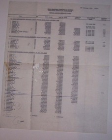 Ballarat Tramway Museum
Document - List, State Electricity Commission of Victoria (SECV), "Tramways Traffic Personnel (Wages), Feb. 1970
Gives a list of names of people who worked on the Ballarat trams in the final 19 months of operations, some personal information and grade.Carbon copy of a typed list of SEC Ballarat Tramway traffic list dated 5 Feb. 1970, with hand alterations. Titled "SECV - Mid Western Electricity Supply Branch - Tramways Traffic Personnel (Wages)", gives a list of names, traffic number, position, date joined, date of birth, date passed as motorman, long service leave (taken or entitlement?) and whether a returned soldier - using letter "R.S." Three shown as "D.S." - disabled solider? List broken up into three components - "A" Motormen/Conductor Seniority List - Engaged prior to 1 Nov. 1952, - 9 Number, "B" engaged subsequent to 1 Nov. 1852 - 8 Number and "C" engaged since 30 May 1962 - 38 depending on the time. List A L Walker H Knight J Smerdon - crossed out A Turnbull - crossed out A Mercer R. Courtney W. Ward R. Williams D. Kellett - (also T/Insp.) A. Jeffreys List B D. McGregor D. Thomson I Willis D O'Leary - underlined J. Maher A. Morris D. Domaschenz R. G. Knight List C E Lake W. Maes I. Tierney B Munn N Cahill N Reynolds - crossed out W. Davies N. Hamilton L. McMahon - crossed out and (W/C) after name. J. Billman W. Nancarrow H. M. Van Oorschot W. Newell L. Bird D. Chambers H. Van Rooy H. Mannion N. Robe C. Harding - crossed out and (S/L) after name E. Van Rooy F. Edmonds - crossed out M. Blackman N. K. Alan - crossed out H. Hall J. Mason S. Davies W. F. Segrave J. F. Bolton - crossed out N. D. Hunt K. Butler - crossed out J. F. O'Brien - ruled out V. L. Gill R. K, Morris D. Everett T. Williams A. Reed R. Herauville - crossed out B. Melville I. Trenfield R. Walker - crossed out V. Thorne - crossed out B. Biddington - crossed out K. Jeffs - crossed out Hynos - in pen and crossed out Power - in pen W. Tuddenham - in pen See also list given in Reg Item 3462.1 and 3462.2 - difference in spelling for Willis = Wallis, and Power = Powell. No additional names, but not all this list names appears in the list in 3462.1Numerous crossings out of names as people left, and three additional names and numbers within circles giving sub totals and totals.personnel, sec, ballarat, crews -
 Bendigo Historical Society Inc.
Book - HOSKING AND HUNKIN COLLECTION: BIBLE, 1800s
HOSKING AND HUNKIN COLLECTION: Small Bible inside envelope. On Binder: New Testament Inside front cover: This Book Belongs to Ellen Nancarrow November 8th 1857 Redruth Coomb Inside second page: This is a present given to Emily Hoskong by her Aunt Helen a a token of Love November 1860. Bible Details: The New Testament of our Lord and Saviour Jesus Christ translated out of the original Greek and with the former translations diligently compared and revised, by his Majestiy's special Command appointed to be read in Churches. Oxford prineted at the Univerity Press for the British and Froreign Bible Society, instituted in London in the year 1804; and sold to Subscribers at the Society house Earl Street, Blackfriers, London. Diamond's 48's 1856. Cum Privilegio Note inside BibleBible given to Emily Hosking (m. Emmanuel Hunkin) from her aunt Ellen (Nancarrow) Redruth Coomb. 8 Nov 1860 prior to sailing to Victoria. Nancarrow = Valley of the Stags. On front of envelope: Her New Testament a precious possesion. Bible given to Emily Hosking (b. 12-2-1854 d. 22-5-1905) by her mother's sister Ellen Nancarrow (b 17 Mar 1827 husband Wm Hosking m. 1853 Rev. John Cornwall Wm. D. 10 July 1914) in 1860 8th Nov before leaving for Australia. Liven and mined at Eaglehawk, Vic. Then Rushworth area (farming) Emblen Hosking nee Nanacarrow RedruthCoomb Cornwall b. 6/3/1831 d. 20/5/1895 Gobarup. Rear of envelope: Yellow and black stickers (Women with flowers and Man with Scythe, and St. Piran's) written on 'Cornish Patron Saint's day - 5th March. Address Label: Ms Betty Night, 29 Gilbertson Street Essendon Vic 3040 Separate page of Notes: A note in the front of Hymn Book Emily Hosking born 12/2/1854 married 1873 her book. A reward - The Bible Christian Sabbath School, Sailors Gully June 29th 1868. Hyms - Bible Christian 2nd edition 1890. Bible Christian Book Room 26 Paxxxx Road E.C. Mrs E. Hunkin Eaglehawk B.C. Church January 21st (18) 94 Husband Emmanuel Huskin born 21/1/1852 - collection of hymns Wesley hymns Emmanuel Hunkin. 2. A collection of hymns Emmanuel Hunkin, Eaglehawk Bendigo.book -
 Melbourne Tram Museum
Album - Photo Album, Michael Schrader, General tramway photos, 1995 - 1997
Album - comprising 23 plastic photo holders in a interleaved pack glued to a heavy plastic sheet covered folder. Matching image and sheet numbers .1 - overhead issue at intersection of Riversdale and Glenferrie Road with parked trams. .2 - University terminus under construction (Dec. 1995) showing track layout and Bendigo tram 808 on City Circle outside Spencer St station and Bourke St. - 1995. .3 - New Exhibition Centre (Jeff's Shed) and trams 852 and A292 in Clarendon St. - Feb. 1996 .3a - Y469 on Zoo Tourist tram - 2/1995 and at the zoo. .4 - Y469 and Z3 200 at the zoo cross over and 469 using the cross over. .5 - Y469 crew photo and overhead work following trackwork in Domain Road at Domain Junction. .6 - Short shunts and bus replacements for Domain Junction works - Z69 and buses. .7 - Volvo bus 89 in Swanston St (replacement) an a view of the Burke Road overpass of the Freeway at Gardiner nearing completion. .8 - ditto showing the new widened level crossing at Gardiner and trams in the distance. Opened Dec. 1995. .9 - Photos showing widening of the freeway at Gardiner and relocation of the creek. .10 - Photos showing the construction of the turnout into the new Southbank Depot - cFeb. 1997. .11 - Photos of four trams and others at South Melbourne depot (closed 8/2/1997) including 981, 954, 923 and 1005 prior to fan trip to move the trams to Malvern Depot. .12 - Photo of one of the trams leaving the depot and two on Queensway Prahran. .13 - Trams 843 and 920 at South Melbourne and 843 and others at Whiteman St shunt. .14 - Tram 843 at Southbank depot entrance on the Port Melbourne Line. .15 - Restaurant trams 442, 937 and 939 at Southbank and tram 114 in Swanston St at Batman Ave. .16 - Z8 leads a fleet of Z class trams in Swanston St and Batman Ave and a large number of buses lined up in Spencer St - Grand Prix tram strike - 1997 .17 - buses buses - Latrobe St and Swanston St. .18 - ditto .19 - Relaying Hawthorn Bridge and relaying Dandenong Road .20 - Track relay Dandenong Road - centre median reserved track with rail wagons .22 - ditto .23 - lifting track into place. Two loose photos - Bundoora terminus, Grand Prix services and Grand Prix information booth.trams, tramways, mmtb, overhead, riversdale rd, glenferrie rd, university, spencer st, city circle, clarendon st, y class, z3 class, a class, trackwork, domain junction, swanston st, burke rd, gardiner, southbank, south melbourne depot, queensway, restaurant tram, dandenong rd, grand prix, bundoora, tram 808, tram 892, tram 292, tram 920, tram 200, tram 69, tram 981, tram 954, tram 923, tram 1005, tram 843, tram 442, tram 937, tram 939, tram 114