Showing 123779 items matching "main-road"
-
 Glenelg Shire Council Cultural Collection
Photograph - Photograph - Main Breakwater construction, Portland, May-55
Port of Portland Authority ArchivesFront: Main b'water from Battery Point 10.5.55 (typed)port of portland archives, main breakwater, construction, portland harbour, harbour development, battery point -
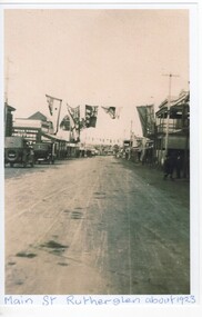 Rutherglen Historical Society
Image, c1923
Black and white photograph of Main Street, Rutherglen, looking west. Written at bottom of photo: "Main St. Rutherglen about 1923"rutherglen, main street -
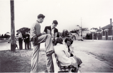 Whitehorse Historical Society Inc.
Photograph, Group at Corner Whitehorse Road and Mitcham Road, 1958
Black and white photo of Group at Corner Whitehorse Road and Mitcham Road. Mitcham Hotel on right.| Two young men nearest camera are:| - Closest is Wally Belfield| - 2nd closest is Laurie O'Rourke.|Directly opposite Opies' Milk Bar and older version of Mitcham's Reserve Hotel.o'rourke, l., mitcham hotel -
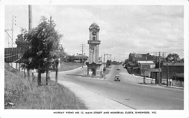 Ringwood and District Historical Society
Photograph/Postcard, Postcard and souvenir photograph - Murray Views No.12. Main Street and Memorial Clock, Ringwood, Vic
Black and white "Murray Views" postcard and souvenir photograph - Ringwood Memorial Clocktower, looking west from cnr. Warrandyte Road and Maroondah Highway, Ringwood, Vic. Circa late 1940s.Printed on back - Post Card - Real Photographs produced in Australia by Murray Views, Gympie, Q. Handwritten - "1949 or 48". -
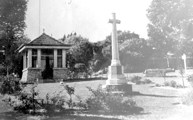 Surrey Hills Historical Society Collection
Photograph, City of Camberwell Council, Surrey Gardens, looking east from Union Road, 1933
The Honor Roll and Shrine in the Surrey Gardens were opened on Sunday 7 April 1918, prior to the cessation of fighting. Mrs Charles H D Steele (MS: Sarah Margaret Russell), president of the local Patriotic League, is credited with the idea of building The Shrine as a fitting memorial to the soldiers of the district. The Surrey Hills Progress Association coordinated raising funds from local residents. John Kendrick Blogg carved the beautiful honor roll in Indian teak and Australian white mahogany and the design of The Shrine was by architectural firm Gawler & Drummond. John Stevens Gawler was a partner in the firm, lived locally and also enlisted. Although he may have been overseas during some of the design process he is often credited with the design. Both men donated their services. The 2 cannons in the gardens were acquired by Mr Arthur Brookes in 1901 to commemorate the end of the Boer War. He was popularly known as 'Empire Brooks' and the cannons as 'Brooks' Babies'. They were originally placed in the grounds of the Guildford Road Recreation Oval. Arthur Brooks was an active community member and one of the founding members of the Surrey Hills Progress Association. Original photo was contained in a booklet printed by Camberwell Council in 1933.This is one of the earliest known photos of 3 elements important in designating the Surrey Gardens as one of the City of Boroondara's heritage gardens, now protected by a heritage overlay. The Shrine was one of the first WW1 memorials to be built in Australia and possibly the first in Victoria. It was unveiled prior to the end of hostilities and was built entirely through local community effort. The design of The Shrine, reflective of domestic architecture, is unusual. Its Honor Roll is also a noted example of sculptor John Kendrick Blogg's work and valued especially for its incorporation of Australian motifs, wattle blossom and gum leaves. The boomerang over the full width of the monument was said to be symbolic of both those who did and did not return. Black and white photo of part of the Surrey Gardens, located between Union Road and Norfolk Road, Surrey Hills. It shows The Shrine, the cannons installed to commemorate the end of the Boer War and the Memorial Cross. Taken from within the park looking east. surrey gardens, shrine of remembrance, monuments and memorials, boer war, mr john kendrick blogg, mr arthur brooks, mrs charles steele, mrs sarah steele, miss sarah margaret russell, cannons, mr john gawler -
 Lorne Historical Society
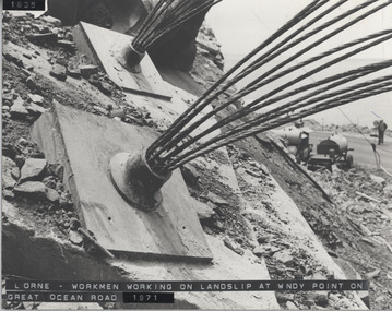
Photograph, Great Ocean Road. Windy point land slip
1971. This was some of the machinery used in stabilsing the Great Ocean Road between the St George's River and the Sheok River. Holes were drilled in the rock and large cables inserted and concrete forced in around themGreat Ocean Road. This was some of the machinery used in stabilizing the G.O.R. at Windy Point, between the St George River and the Sheoak River. Holes were drilled in the rock and large cables inserted and concrete fixed around them. This took place in late 1971great ocean road. g.o.r. landslip. windy point. 1971 -
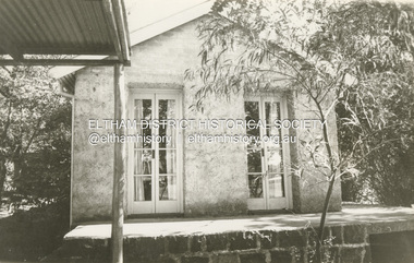
 Eltham District Historical Society Inc
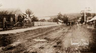
Photograph, Main Street, Greensborough, c.1910, 1910c
Early view of Main Street Greensborough showing the mainly residential nature of the buildings. Photographs from the collection of Peter Blackbourn, a descendant of the Chapman Stock family.Photograph copy originally located in a magnetic style album titled 'Greensborough Bypass 1990s 5' suffering significant degradation. No information contained in album or on reverse of photos except where noted. Relocated to archival photosafe storage.greensborough, main street -
 Stawell Historical Society Inc
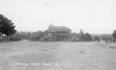
Postcard, Stawell Coffee Palace formerly the Castlemaine Hotel and Rotunda in Lower Main Street -- Post Card
Stawell Coffee Palace formerly Castlemaine Hotel and Rotunda Lower Main Street. Post Card 13. D.S. King Moore Street East Araratstawell -
 Stawell Historical Society Inc
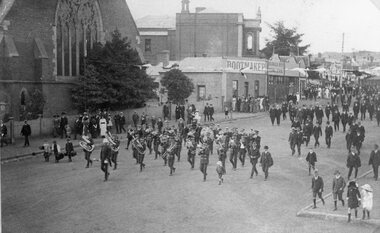
Photograph, Street Parade in Main Street led by Stawell Band near Holy Trinity Church
Main Street. Street Parade led by Stawell Band near Holy Trinity Church. Bootmaker Mr Webster. Barker Bros Grocers. Town Hall. stawell -
 Stawell Historical Society Inc
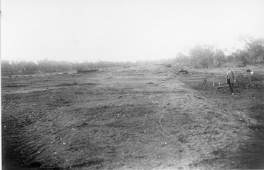
Photograph, Stawell Wheat Site Construction beside the main rail line behind the Pleasant Creek Training Centre and Woollen Mills -- Demolished 1945-1946
Building Stawell Wheat Site situated beside the main rail line behind the Pleasant Creek Training Centre and Woollen Mills. Demolished 1945-1946stawell -
 Stawell Historical Society Inc
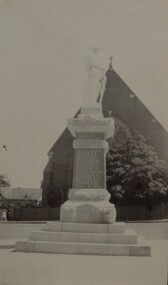
Photograph, Soldiers’ Memorial World War 1 in Main Street -- Different angle
Side view Soldiers’ Memorial World War 1 c1924 -1925. In the background is the Anglican Church, and doctors' residence & surgery. The photograph is taken in Main St.Another black and white side view of the Soldiers Memorial World War 1. looking towards the Anglican Church c1924 -1925. The view also shows the doctors residence and surgery on the left. stawell ww1 -
 Stawell Historical Society Inc
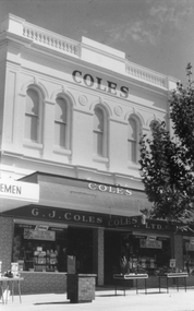
Photograph, G. J. Coles Shop at 113 Main Street Stawell
Black and white photograph of shop 113 Main Street was once Coles retail shop. In 2013 the shop changed hands and became Lyal Eales store. Black & white photograph of a two story brick building with parapet on top. Two large display windows on ground floorG.J. Coles Pty. Ltd.g. j. coles retail shop stawell -
 Stawell Historical Society Inc
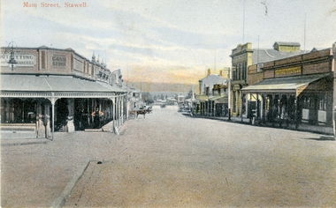
Photograph, Main Street Stawell looking West from opposite Star Lane 1954
Main Street Stawell looking West from area in front of Bull and Mouth Hotel. Cash store Danes on left. George Mitchell's on right. c1900stawell businesses streetscape -
 Melbourne Tram Museum
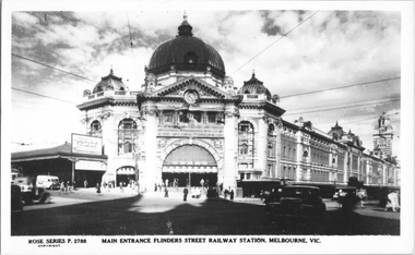
Postcard, Rose Stereograph Co, "Main Entrance Flinders Street railway station, Melbourne", late 1940s
Rose Series postcard No. P 2788, titled "Main Entrance Flinders Street railway station, Melbourne", during a winter's morning. Photo late 1940s.Yields information about the main entrance of Flinders St station in the late 1940s.Postcard - printed real photograph with Rose Stereograph Co. name on the rear.tramways, trams, flinders st station, flinders st, swanston st -
 Stawell Historical Society Inc
Photograph, Salvation Army -- Crowd at Opening of Citadel Main Street Stawell 1934
Salvation Army Crowd at Opening of Citadel Main Street in 1934. A large crowd in front of new building. The photo was taken on the opening of the Citadel, December 1934.Black and white photo depicting a large group of people out the front of a brick building. Large windows are either side of the building entrance and written above the arched doorway, The Salvation Army Citadel. Weather board house to the left, also to the right a weather board building with a sign "Entrance to Peoples Hall Primary Section". W.J. Chapman Photo Artist Stawell. Reeve opening of Citadel December 1934 in pencil.stawell religion -
 Rutherglen Historical Society
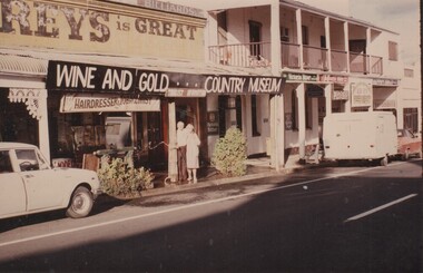
Image, January 1986
This shop, in Main Street Rutherglen, near Poachers Paradise pub (originally the Rutherglen Hotel), was owned and operated as a barber shop by Jack O'Keefe. This photograph was taken in 1986. The couple in front of the building are probably Jack O'Keeffe and his wife. At present (2019) part of this shop is again operating as a hairdressers, as Jack and the Fox.Colour photograph of the front of a shop with a banner below the veranda identifying it as the Wine and Gold Country Museum. The building is located in Main Street Rutherglen next to the Poachers' Paradise Hotel. Below the banner is a shop sign "Hairdresser & Tobacconist" and another "Tourist Information". A man and woman are standing in front of the shop watering the plants. Above the veranda is another sign indicating that some part of the shop was once used as a billiard parlor.Writen on the back of the photo: "January 1986"jack okeefe, barbers, hairdressers -
 Whitehorse Historical Society Inc.
Postcard, Blackburn Road and Railway Road Blackburn C1908, 1908
Black and white postcard entitled 'Blackburn' Scene shows corner Railway and Blackburn Roads, Albert Street unmade.railway road, blackburn, hooke, janet emily, blackburn road blackburn, albert arthur -
 Whitehorse Historical Society Inc.
Photograph, Deep Creek Road, Mitcham, 1/01/2001
Black and white photograph of Deep Creek Road, taken from lower entrance of Schwerkolt Cottage Reserve showing Glenvale Road on left. Taken before work started on new bridge and road.deep creek road, mitcham, glenvale road, ringwood -
![Map, Plan showing proposed deviation of the road through McKenzie's Flat to Bacchus Marsh. [Undated]](/media/collectors/5e461d8021ea67224c82f2a1/items/677d22f37f2053f3e5d500dc/item-media/677d25247f2053f3e5d50950/item-fit-380x285.jpg) Bacchus Marsh & District Historical Society
Bacchus Marsh & District Historical SocietyMap, Plan showing proposed deviation of the road through McKenzie's Flat to Bacchus Marsh. [Undated]
The date of this map or plan is uncertain. McKenzie's Flat is a bushland picnic area on the Lerderderg River in the Lerderderg State Park close to Bacchus Marsh. The proposed road deviation shown on this map is very close to a sharp bend in the Lerderderg River which shows an island in the centre of that bend. The name of a landholder, J.B. Perry is shown on the map close to the area of the road deviation.The land shown is identified as within the Parish of Merrimu.Single page map showing a proposed deviation of the road from McKenzie's Flat to Bacchus Marsh. Scale: 5 chains to 1 inch. Part of a set of maps which are pasted into a bound volume containing 76 maps or plans in total. High resolution digital image stored on BMDHS computer network. mckenzies flat bacchus marsh, bacchus marsh roads and streets -
Whitehorse Historical Society Inc.
Legal record - Land Title, Springvale Road, 1960
Aerial photograph of cnr. Springvale Road and Burwood Highway, south past Highbury Road and east to Vermont South.Aerial photograph of cnr. Springvale Road and Burwood Highway, south past Highbury Road and east to Vermont South.Aerial photograph of cnr. Springvale Road and Burwood Highway, south past Highbury Road and east to Vermont South.aerial photographs, springvale road, burwood east, burwood highway, burwood east, highbury road, burwood east, vermont south -
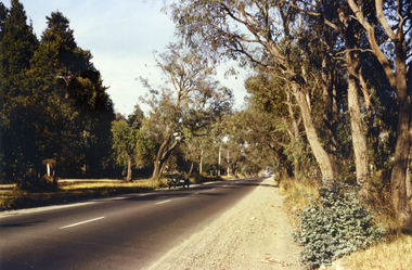 Whitehorse Historical Society Inc.
Photograph, Canterbury Road, Vermont, 1967
Part of Tim Shambrook's Collection for 'This is Vermont'. Not used.Coloured photo of Canterbury Road, Vermont, taken in 1967 showing one lane road and heavily treed verge.canterbury road, vermont, shambrook, tim -
 Whitehorse Historical Society Inc.
Photograph, Brunswick Road, Mitcham, 8/09/1958 12:00:00 AM
Black and white photo of Brunswick Road, Mitcham. (Was previously Northcote Road.) Comments as for Forster Street Mitcham. - NP1075.o'rourke, l. -
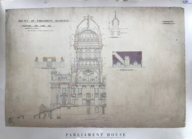 Greensborough Historical Society
Poster, Parliament House Victoria, Parliament House Victoria: Main entrance. Portico, vestibule and dome, 1879_
A facsimile of the original main entrance, portico, vestibule and dome for Parliament House Melbourne. An illustration by Peter Kerr, architect, 1879. The dome above the vestibule was never built.Facsimile poster, printed in colour on one side.parliament house melbourne -
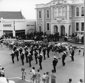 Stawell Historical Society Inc
Photograph, Band Competition in Lower Main Street 1969 in front of Town Hall --3 Photos
Three photographs of Band Competition. Street March 1969 in front of Town Hall and McCracken's Main Street. Borthwicks. The Commercial Bank. Post Office and Foodland Visible.stawell streetscape -
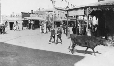 Stawell Historical Society Inc
Photograph, Main Street Stawell corner of Wimmera Street with Stabbs Coach Building visable c1920's, 1920
Sepia photo of Stawell Main Street Scene. Stabb's Coach Building on corner of Wimmera Street visible. C1920's. Possibly Easter bunting hanging in the street.Sepia Photograph of a scene in a commercial area. People in the Street. A Cow in the foreground. Stawell from the side of the P.O. (Nell Kingston)stawell -
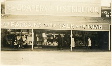 Stawell Historical Society Inc
Photograph, O. Gilpin Drapery shops & later was part of the Albion Hotel in Upper Main Street Stawell
Business O. Gilpin Drapery shops later part of the Albion Hotel Upper Main Street. G Thurgoods Butcher shop next door on right of photo.stawell business drapery streetscape -
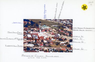 Stawell Historical Society Inc
Photograph, Stawell Methodist Church in Main Street Stawell -- Aerial View showing other buildings as well c1980
Stawell Methodist Church. Main Street Stawell. Aerial View. Shows Croquet Green. Kingston's Bus Depot. Doctors Surgery Mr Gunning's House. C1980stawell -
 Eltham District Historical Society Inc
Photograph, Neville F. Emerson, Shoestring, Metery Road, Eltham, n.d
Stamped on reverse: Neville F. Emerson Estate Agent 81 Main Rd., Lower Plentyeltham, metery road, neville f. emerson real estate (lower plenty), shoestring, houses -
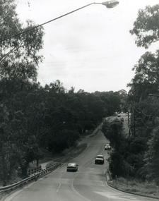
 Ringwood and District Historical Society
Photograph, Maroondah Highway West, Ringwood- c1973. Westward view from Ringwood Street/Wantirna Road
Black and white photographWritten on rear of backing sheet: " Main Street looking West from Ringwood Street, 1973. -
Surrey Hills Historical Society Collection
Planning report, City of Boroondara, City of Boroondara planning report re 171 Union Road, Surrey Hills, 19/07/2004
171 Union Road was part of the Thomas Zeplin estate. It originally had a Victorian house on it built by the Zeplin family. This was leased by Dr Percy Liddle and then Dr James Landells Blakie. Dr Blakie purchased land diagonally opposite at 174 Union Road and had a purpose-built home / surgery constructed. Later the site was occupied by COR then a BP petrol station.A detailed proposal regarding the redevelopment of the petrol station site on the corner of Union Road and Montrose Street, Surrey Hills into a 2 storey office and shop building with basement parking and access from Montrose Street. It includes attachments showing plans, elevations and details regarding objectors. The application was granted subject to additional conditions being met. union road, redevelopment, shops, town planning