Showing 25665 items
matching plenty-township-estate
-
 Bendigo Historical Society Inc.
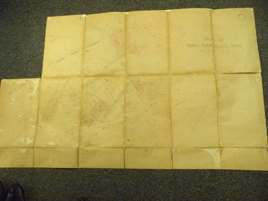
Map - MAHER'S AND PRETTY'S ESTATE, 8/02/1926
Map: Maher's and Pretty's Estate, Parish of Toolamba West, County of Rodney. Parish plan Canvas backed. ( number 131 in Map Cupboard 1)map, rodney, rural, maher's , pretty's, toolamba west, county of rodney -
Bendigo Historical Society Inc.
Map - BURNEWANG PARK ESTATE, circa 1920
Map: Burnewang Park Estate, Parishes of Diggorra and Minto, County of Bendigo, Parish Plan ,Canvas backed ( number 127 in Map Cupboard 1)map, bendigo, rural, burnewang, diggorra, minto, county of bendigo -
 Hume City Civic Collection
Photograph
The series of photographs were taken after exceptional heavy rain had fallen in Sunbury in the early 1990s. The Jackson Creek overflowed its banks and the surrounding flood plain area was under water.A coloured photograph of the Jackson Creek in flood along a river flat within the Rupertswood Estate. There are bare hills in the background and a fenced off run in the foreground.floods, weather patterns, jacksons creek, george evans collection -
 Whitehorse Historical Society Inc.
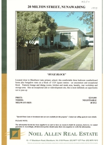
Document, Milton Street, Nunawading, 1998
Colour sale brochure for 20 Milton Street,Colour sale brochure for 20 Milton Street, Nunawading, 3 bedroom weatherboard. Agent: Noel Allen Real Estate. No date given but 1998.Colour sale brochure for 20 Milton Street,land sales, milton street nunawading. no 20. -
Whitehorse Historical Society Inc.
Article, Public fear, 1993
Residents of Branksome Grove, Blackburn South are protesting about the threat to protected trees posed by Urban Land Authority developers of the new Banksia Estate.Residents of Branksome Grove, Blackburn South are protesting about the threat to protected trees posed by Urban Land Authority developers of the new Banksia Estate.Residents of Branksome Grove, Blackburn South are protesting about the threat to protected trees posed by Urban Land Authority developers of the new Banksia Estate.town planning, branksome grove, blackburn south, victoria. urban land authority, mcgregor, greg, banksia estate -
Whitehorse Historical Society Inc.
Map, Blackburn and Doncaster, 1950, 1950
Map of part of Blackburn and Doncaster from Morgan's Street Directory, 1950. Advertisement for G.S. Grover, Real Estate Agent, Main Road, Doncaster.Map of part of Blackburn and Doncaster from Morgan's Street Directory, 1950. Advertisement for G.S. Grover, Real Estate Agent, Main Road, Doncaster.Map of part of Blackburn and Doncaster from Morgan's Street Directory, 1950. Advertisement for G.S. Grover, Real Estate Agent, Main Road, Doncaster.maps, blackburn, grover, g.s., doncaster -
Whitehorse Historical Society Inc.
Document, Certificate of Title, 1923, 1933
Certificate of Title - Estate of William TilleyCertificate of Title - Estate of William Tilley, Lot 77 Cook Street, Mitcham. Vol 4781, Fol 956069. Rates Enforcement of Charge, 1933Certificate of Title - Estate of William Tilleyland titles, shire of blackburn and mitcham, tilley, william, rates, cook street, mitcham -
Whitehorse Historical Society Inc.
Article, A Love of yesteryear
Sale notice of a Californian bungalow in Canterbury Road Forest Hill, built by Frank Fisher, agents for Hill 60 Estate, first subdivided in 1929.Sale notice of a Californian bungalow in Canterbury Road Forest Hill, built by Frank Fisher, agents for Hill 60 Estate, first subdivided in 1929.Sale notice of a Californian bungalow in Canterbury Road Forest Hill, built by Frank Fisher, agents for Hill 60 Estate, first subdivided in 1929.californian bungalows, canterbury road, forest hill, no. 327, fisher, frank, hill 60 estate, forest hill -
Whitehorse Historical Society Inc.
Letter - Correspondence, George Family, 13/06/1972 12:00:00 AM
Letter from L.M. Lightwood nee George to Miss Leach regarding land held by George family members, including part of Keogh estate.Letter from L.M. Lightwood nee George to Miss Leach regarding land held by George family members, including part of Keogh estate.Letter from L.M. Lightwood nee George to Miss Leach regarding land held by George family members, including part of Keogh estate.george family, mitcham, nunawading, keogh's estate -
Canterbury History Group
Ephemera - 36 Wattle Valley Road Canterbury, 1994
Real Estate Advertisement for the auction on 12th November 1994 of 36 Wattle Valley Road c1937. Includes black and white sketch of the exterior of the housecanterbury, wattle valley road, reeves john, sinclair & co -
Canterbury History Group
Ephemera - Affordable renovated Edwardian, [1996]
Real estate advertisement for the sale by auction of 31 Myrtle Road Canterbury on Saturday 13 April [1996]. Includes a sketch of the house and a floor plancanterbury, myrtle road, edwardian style -
Canterbury History Group
Ephemera - Affordable Edwardian circa 1907, [1992]
Real estate advertisement for the sale by auction of 2 Scott Street Canterbury on Saturday 16 May[1992]. Includes a sketch of the house and floor plans.canterbury, scott street, edwardian style -
Canterbury History Group
Ephemera - Beltramini 1903, 2003
Real estate advertisement for the sale by auction on 31 August 2003 of Beltramini , 169 Canterbury Road Canterbury. includes coloured photographs of the exterior and interiorcanterbury, canterbury road, beltramini, queen anne style -
Canterbury History Group
Ephemera - Last chance! only one left, {2000}
Real estate advertisement for the sale of 2/12 Balwyn Road Canterbury, a single storewn residence. includes a sketch of the exterior of the residence and a floor plan.canterbury, balwyn road, townhouses -
Canterbury History Group
Ephemera - 13 Chaucer Crescent Canterbury, 1998
Real estate advertisment for the sale of 13 Chaucer Crescent Canterbury in 1998. Includes coloured photographs of the interior and exterior of the house and floor and site plans.canterbury, chaucer crescent, swimming pools -
Canterbury History Group
Ephemera - A house of generous proportions, 1992
Real estate advertisement for the sale by auction of 12 Maling Road Canterbury on Saturday 12 December 1992. Includes a sketch of the house and floor plan.canterbury, maling road, edwardian style -
Canterbury History Group
Ephemera - Canterbury, 19 View Street, 1/05/2013 12:00:00 AM
Real estate advertisement for the auction of 19 View Street Canterbury, 12 May 2012. Includes coloured photographs of the interior and exterior and floor plancanterbury, view street, victorian style, fireplaces, lead lights -
Canterbury History Group
Ephemera - 188 Prospect Hill Road Canterbury, 1/12/2002 12:00:00 AM
Real estate advertisement for the auction of 188 Prospect Hill Road on 7 December 2002. Includes coloured photographs of the exterior and floor and site planscanterbury, prospect hill road, fountains, gardens -
Canterbury History Group
Ephemera - On the Grand Scale, 1999
Real Estate Advertisement for the auction of 24 Balwyn Road, on 27 February 1999. Includes coloured photographs of the interior an exterior view and floor plancanterbury, balwyn road, noel jones -
 Ballarat Tramway Museum
Photograph - Colour Photograph/s - set of 8, Carolyn Dean, 22/11/2000 12:00:00 AM
Set of eight colour prints of the Ballarat COTMA Conference 2000 visits to the MTPA depot at Haddon, the township of Clunes and to CMR Muckleford Photographed on 22/11/2000 at Haddon and on 23/11/2000 at Clunes and Muckleford. Photographs by Carolyn Dean. .1 - No. 663, 670 and 407 at Haddon MTPA depot .2 - COTMA delegates at Haddon BBQ .3 - No. 407 on operating track at Haddon .4 - Clunes war memorial .5 - Clunes township main street .6 - Muckleford station nameboard .7 - J549 at Muckleford station .8 - ditto Printed on Kodak paper.On rear of each print is "263.3 or .4, or .5" and date "22.11.00" or "23.11.00" in ink.btm, haddon, cotma, muckleford, clunes, tram 663, tram 670, tram 407 -
 Kew Historical Society Inc
Plan - Subdivision Plan, 6 Choice Residential Allotments: East Kew, 1932
Prue Sanderson, in her groundbreaking ‘City of Kew Urban Conservation Study : Volume 2 - Development History’ (1988), summarised the periods of urban development and subdivisions of land in Kew. The periods that she identified included 1845-1880, 1880-1893, 1893-1921, 1921-1933, 1933-1943, and Post-War Development. These periods were selected as they represented periods of rapid growth or decline in urban development. An obvious starting point for Sanderson’s groupings involved population growth and the associated economic cycles. These cycles also highlighted urban expansion onto land that was predominantly rural, although in other cases it represented the decline and breakup of large estates. A number of the plans in the Kew Historical Society’s collection can also be found in other collections, such as those of the State Library of Victoria and the Boroondara Library Service. A number are however unique to the collection.Subdivision plans are historically important documents used as evidence of the growth of suburbs in Australia. They frequently provide information about when the land was sold on which a built structure was subsequently constructed as well as evidence relating to surveyors and real estate and financial agents. The numerous subdivision plans in the Kew Historical Society's collection represent working documents, ranging from the initial sketches made in planning a subdivision to printed plans on which auctioneers or agents listed the prices for which individual lots were sold. In a number of cases, the reverse of a subdivision plan in the collection includes a photograph of a house that was also for sale by the agent. These photographs provide significant heritage information relating house design and decoration, fencing and household gardens.The mansion Woodlands in Harp Road, East Kew suffered the death of a thousand cuts. In its case, the cuts were subdivisions. Previous subdivisions of the mansion and its grounds were given titles such as ‘The Eastlawn Estate’ (MAP.0055), whereas at the end, the subdivision called it as it was, naming itself the ‘final section of the Woodlands Estate’ when it was put up for auction in 1932. The emphasis in the promotion of the subdivision was that it provided purchasers with splendid opportunities ‘to build modern homes in select, well established modern surroundings’. As with other subdivisions in the interwar period, transport links were emphasised. The six residential lots cut Woodlands off from Harp Road. When the vendor, Louisa Rachel Preston Hill, was to die at Woodlands in 1937 aged 86 her address was given as Normanby Road.subdivision plans - kew, woodlands estate -
 Kiewa Valley Historical Society
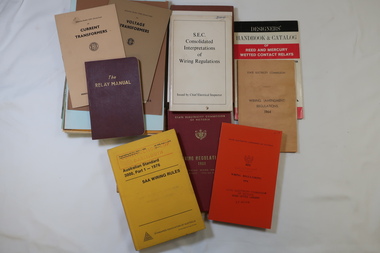
Books - SECV Text Books x19, Voltage Transformers and Wiring Regulations
The SECV constructed the Kiewa Hydro Electric Scheme including the township of Mt Beauty. Text books were available for the workers.The books were used by the workers on the Kiewa Hydro Electric Scheme.Variety of text books some published by the SECV on the topics - 'Voltage Transformers' and 'Wiring Regulations'secv, voltage transformers, wiring regulations -
 Eltham District Historical Society Inc
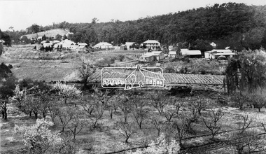
Photograph, View at Hurstbridge, 1924
View of Hurstbridge township overlooking fruit trees in flower in the foregaround and ploughed paddocks ready for crop planting in the middle of the photo.This photo forms part of a collection of photographs gathered by the Shire of Eltham for their centenary project book, "Pioneers and Painters: 100 years of the Shire of Eltham" by Alan Marshall (1971). The collection of over 500 images is held in partnership between Eltham District Historical Society and Yarra Plenty Regional Library (Eltham Library) and is now formally known as The Shire of Eltham Pioneers Photograph Collection.' It is significant in being the first community sourced collection representing the places and people of the Shire's first one hundred years.Digital imagesepp, shire of eltham pioneers photograph collection, hurstbridge, orchard, fruit trees -
 Yarra Glen & District Historical Society
Map, Plan of Yarra Glen Water Area
The map has been used by water supply officers to map the supply of water to properties in the township area of Yarra Glen.The item is significant because it records changes to the supply of water to Yarra Glen over a period of approximately 100 years. It also records property owners and subdivisions.Flat map which folds into 12 pages with a dark red cloth cover. One page in top left corner is missing. Scale of the map is 300 feet to an inch. Cream coloured packing tape has been placed along the back of the folds and is now peeling off.Round stamp in top right corner "Shire of Eltham". Pencil note on top left existing page "Note - includes record of 8 LP's subdivisions. HC". Information has been added to the map over an extended period of time in red ink, black pencil, blue pencil and blue biro.yarra glen/water supply/ -
 Clunes Museum
photograph, KODAK PRINT
VIEW OF GRAVEL ROAD FROM CLUNES TOWNSHIP TO STATION FLAT. LOWER PART OF PORT PHILLIP MINE ON LEFT OF PHOTO.VIEW OF ROAD LEADING TO STATION FLAT CLUNES. ANGLICAN CHURCH ON HILL IN BACKGROUND.local history, photography, photographs, clunes landscape. -
 Sunbury Family History and Heritage Society Inc.
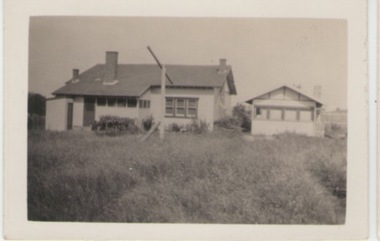
Photograph, c1920s - 1930s
In the 1920s a few Californian style homes were built in the township of Sunbury and some of them can still be seen in the town.A black and white photograph of the rear view of a weatherboard Californian style bungalow built in an open paddock. The house also has a smaller building on the RHS and an outdoor toilet as well as a double clothes line are in the yard. sunbury township. -
 Stawell Historical Society Inc
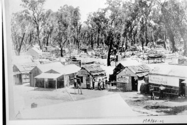
Photograph, Mafeking Goldfield at Mt William with Photographer, Hairdresser and other buildings c1900
Mafeking Goldfield Mt William Mining Scene c1900. Businesses in township. W Hale Photographer. Hairdresser and other buildings. stawell -
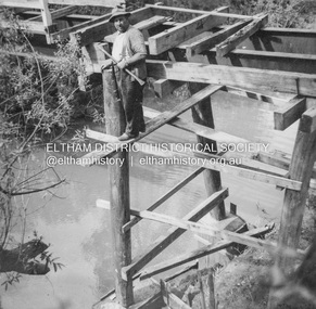 Eltham District Historical Society Inc
Album - Photograph, J.A. McDonald, General; Albion Street and Eltham-Yarra Glen Road, Oct. 1955
Eltham-Yarra Glen Road Lower Plenty Footbridge October 1955 (Jolly)Record of various Shire of Eltham infrastructure works undertaken during the period of 1952-1962 involving bridge and road reconstruction projects, sometimes with Eltham Shire Council Project Reference numbers quoted. It was during this period that a number of significant improvements were made to roads and new bridges constructed within the shire that remain in place as of present day (2022). In many situations, the photos provide a tangible visible record of infrastructure that existed throughout the early days of the Shire. The album was put together by or under the direction of the Shire Engineer, J.A. McDonald.infrastructure, road construction, shire of eltham, 1955-10, bridge construction, eltham-yarra glen road, lower plenty footbridge -
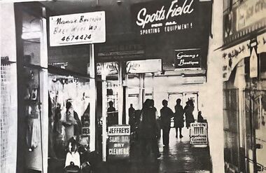 Greensborough Historical Society
Photograph - Newspaper Clipping - Digital Image, The Valley Voice, Bundoora Square 1978, 03/08/1978
Bundoora Square is the shopping centre on the corner of Plenty Road and Settlement Road Bundoora. Digital copy of newspaper photographbundoora square, bundoora shopping centre, plenty road bundoora -
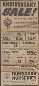 Greensborough Historical Society
Advertisement - Digital image, Diamond Valley News, Bundoora Nurseries, 1974, 24/09/1974
Advertisement for Bundoora Nurseries, corner Plenty Road and McLeans Road Bundoora, 1974.Digital copy of newspaper advertisement.bundoora nurseries, plenty road bundoora, mcleans road bundoora