Showing 23244 items matching "smythes-creek"
-
 Ringwood and District Historical Society
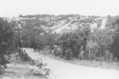
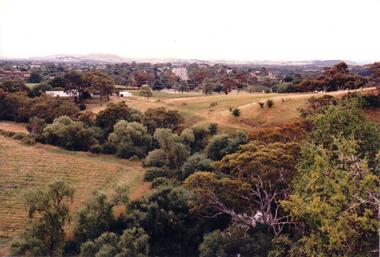
Photograph, View of Glenvale Road, Ringwood. Warnes Road in left background 1964
See Also #25Written on back of photograph, "1964 - View of Glenvale Road. Supplied by Garrett Gundry. Warnes Road in left background. Deep Creek Road in centre background." -
 Ringwood and District Historical Society
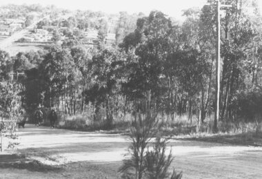
Photograph, View of Glenvale Road, Ringwood 1964
See Also #25Written on back of photograph, "1964 - View of Glenvale Road. Supplied by Garrett Gundry. Warnes Road in left background. Deep Creek Road in centre background." -
 Ringwood and District Historical Society
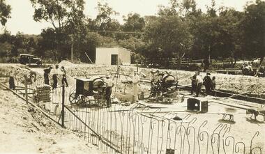
Photograph, Building the old Ringwood baths in Ringwood St 1934
Black and white photograph. 2 copies- 1 large, 1 small.Typed below photograph, "Building the old Ringwood baths in Ringwood St. The car is in Ringwood St. and the bridge over the Mullum Creek can be seen. 1934". -
 Stawell Historical Society Inc
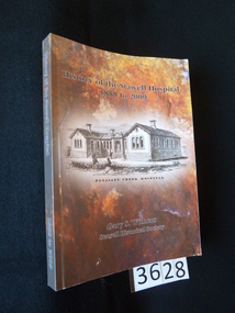
Book, Gary Withers, History of Stawell Hospital - Previously Cat No 3628, 2009
The history of the Stawell HospitalMulti colour card cover with drawing of a brick building with three people in front.History of the Stawell Hospital 1858 - 2009 Pleasant Creek Hospital Gary S. Withers Stawell Historical Society To Stawell Historical Society G Withersstawell medicine -
 Glenelg Shire Council Cultural Collection
Photograph - Photograph - Portland scene, c. 1970
Photographic print of a rephotographed photograph. Image shows lower north slope Observatory Hill, fence along base, then wooden bridge over Salt Creek that drains into bay, near the Spit Portland.Front: 'Bridge over Portland drain' - green ink -
 Ringwood and District Historical Society
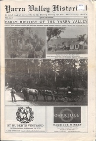
Newspaper, Yarra Valley Historical - A brief look at early life in the Yarra Valley during the mid 1800s to the 1900s (issued circa 2010)
Early History of the Yarra Valley (Vol l Issue 2) Coldstream, Yering, Christmas Hills, Steels Creek, Gulf Station, Toolangi, Tarrawarra, Healesville, Fernshaw, The Black Spur, Narbethong, Marysville. -
 Federation University Historical Collection
Photograph, Gold Dredge
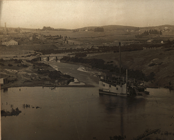
Black and white mounted photograph of a dedge floating on a body of water which has a creek flowing into it, and rolling hills in the background. The buildings associated with a mine or factory are shown on the top left hand side. Signed "Martin ?ish Victoria St" verso "R.H. Brooke, "Callantina Villa", Glenferrie Rd Sthdredge, dredging, mining, river, callantina villa, gold mining -
 Bendigo Historical Society Inc.
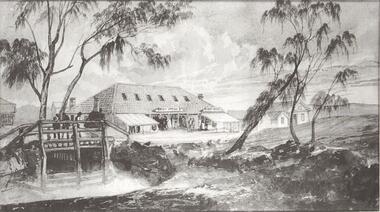
Photograph - POST OFFICE AND SURVEY OFFICE BENDIGO
Black and white photocopy enlarged. Sketch of Post Office, Survey Office Bendigo and other building. Wooden bridge over creek. Inscriptions: on front - rubber stamp 'Bendigo Historical Society Inc.'buildings, post office -
 Bendigo Historical Society Inc.
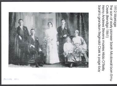
Photograph - WEDDING PHOTO: HENRY STEVENS AND HILDA O'REILLY
black and white copy of photo: image shows 1912 marriage of Henry Andrews Stevens and Hilda O'Reilly. Henry is the son of early pioneer Sarah McDowall, born Emu Creek ( Bendigo 1861 )person, group, henry stevens, hilda o'reilly, emu creek, sarah mcdowall, hilda o'reilly, reginald clark. -
 Hume City Civic Collection
Photograph, c 1980s
The photograph although recently taken shows the original settled area in Sunbury, which included Goonawarra Vineyard and Macedon Street which was once the business centre of Sunbury township before the railway was established.A coloured photograph of Sunbury Township looking west from above Jacksons Creek and Goonawarra Winery. Macedon Street can be seen in the middle distance and Mt. Holden and Burke Hill are across the skyline.sunbury township, mt. holden, burke hill, francis, james goodall, barnier, john, jacksons creek, goonawarra winery, george evans collection -
 Sunshine and District Historical Society Incorporated
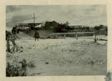
Photograph (1954) - Flooded Bridge, 1954
1954 Photograph of KOROROIT CREEK in flood and overflowing the DERBY RD BRIDGE in Sunshine. Short time later this bridge was declared unsafe and closed to vehicle traffic. The Sunshine Technical School building is in the background.derby rd bridge, flood, kororoit creek, sunshine technical school, 1954 -
 Clunes Museum
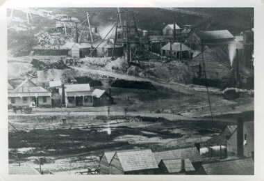
Photograph, JEAN GORDON GOVERNMENT PRINTER. MELBOURNE
BLACK AND WHITE PHOTOGRAPH OF PORT PHILLIP MINE - LOOKING NORTH FROM WEST SIDE OF CAMP HILL.TULLAROOP CREEK WITH CAMP STREET FORD, PORT PHILLIP HOTEL AND MINING BUILDINGS AND MINING CONSTRUCTIONSphotographs, mining, port phillip mine -
 Clunes Museum
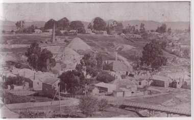
Photograph
BLACK AND WHITE PHOTOGRAPH OF CLUNES TOWNSHIP. SMOKE STACKS, MULLOCK HEAPS, TWO POPPET HEADS, TWO BRIDGES OVER CREEK, DWELLINGS. SEVERAL LARGE TREES AND SMALLER TREES IN TREE GUARDS.local history, photography, photographs, clunes township -
Whitehorse Historical Society Inc.
Document, Bridge divides locals, 2010
Report of proposal by Deakin University, Burwood Campus to construct a 200m. bridge over Gardiners Creek to connect two portions of its campus, and comments from West Elgar Residents Association spokeswoman.Report of proposal by Deakin University, Burwood Campus to construct a 200m. bridge over Gardiners Creek to connect two portions of its campus, and comments from West Elgar Residents Association spokeswoman.Report of proposal by Deakin University, Burwood Campus to construct a 200m. bridge over Gardiners Creek to connect two portions of its campus, and comments from West Elgar Residents Association spokeswoman.west of elgar residents association, gardiners creek, deakin university. burwood campus -
Whitehorse Historical Society Inc.
Map, City of Whitehorse, 1/03/1995 12:00:00 AM
Map showing streets of the City of Whitehorse from Mullum Mullum Creek to the north to Highbury Road and Warrigal Road in the west, to Heatherdale Road in the east.Map showing streets of the City of Whitehorse from Mullum Mullum Creek to the north to Highbury Road and Warrigal Road in the west, to Heatherdale Road in the east. Prep. by Richard Meloni. Scale 1:15,000Map showing streets of the City of Whitehorse from Mullum Mullum Creek to the north to Highbury Road and Warrigal Road in the west, to Heatherdale Road in the east. city of whitehorse, mullum mullum creek -
Tatura Irrigation & Wartime Camps Museum
Book, Grass Seeds and Thistles
Book about the early years of Moora Gobarup and Wanalta. Written by local historian Alan McLean.264 page book by Alan McLean. Picture of trees and remains of a stone building on front. Title in blue, authors name in white. Back cover has two photographs of Wanalta Creek weir.moora victoria, gobarup victoria, wanalta victoria, wanalta creek weir, stewart family -
 Southern Sherbrooke Historical Society Inc.
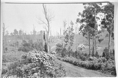
Photograph - Aura, Menzies Creek
Photo taken from the Menzies Creek railway station. St. Cuthberts Church is seen in the distance with a dirt road winding past and up hills with trees. In the foreground there are flower bushes and other shrubs. -
 Bendigo Historical Society Inc.
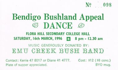
Document - PETER ELLLIS COLLECTION: BENDIGO BUSHLAND APPEAL 1996, 16th March, 1996
Ticket to Bendigo Bushland Appeal Dance to be held at the Flora Hill Secondary College Hall Saturday 16th March 1996 8pm to 12.30am. Music generously donated by Emu Creek Bush Band.education, secondary, bendigo bushland appeal dance -
 Bendigo Historical Society Inc.
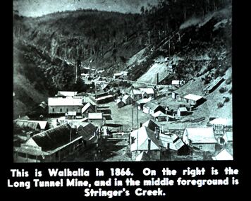
Slide - DIGGERS & MINING. DIGGERS AND MINERS, c1864
Diggers & Mining. Diggers and miners. Walhalla - Gold Town. This is Walhalla in 1864. On the right is the Long Tunnel Mine, and in the middle foreground is Stringer's Creek. Markings: 13 995 WAL. Used as a teaching aid.hanimounteducation, tertiary, goldfields -
 Bendigo Historical Society Inc.
Photograph - PETER ELLIS COLLECTION: BUSH BAND
Colour photo band on stage. 4 Men standing. Back of photo reads: Emu Creek Goornong Aust. Day Concert. Des Skinner Peter Ellis Bradley Baker Stan Symes.photo, group, musicians -
 Bendigo Historical Society Inc.
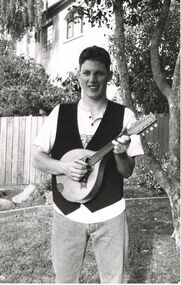
Photograph - PETER ELLIS COLLECTION: MAN PLAYING LUTE
Black and white photograph. Young man playing a lute. Standing in garden under tree. Fence and neighbouring building are visible behind him. Back of photo reads: Anton Marrone Emu Creekphoto, individual, musician -
 Bendigo Historical Society Inc.
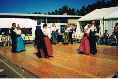
Photograph - PETER ELLIS COLLECTION: DANCING
Colour photograph. People dancing on wooden stage in front of marquee. Back of photo reads: 14A/2 NFF Canberra. Bush Dance & Music Club of Bendigo Dancing Emu Creek Playingentertainment, dance, bendigo old time dance club -
 Bendigo Historical Society Inc.
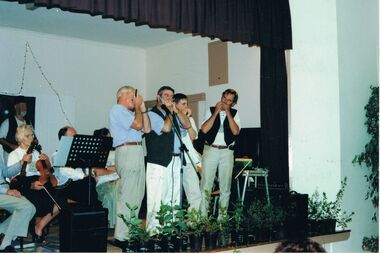
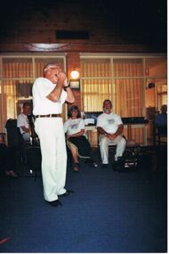
Photograph - PETER ELLIS COLLECTION: EMU CREEK BUSH BAND, 252th November, 2007
Colour photograph. Emu Creek Bush Band playing in hall. Blue carpet. Man playing harmonica. Back of photo reads: Bendigo Retirement Village 25.11.2007 Des Skinner - Mouth Organ.entertainment, music, emu creek bush band -
 Kew Historical Society Inc
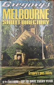
Book, Gregory's Publishing Company Pty Ltd, Gregory's Street Directory of Melbourne and suburbs and Metropolitan Road Guide, 1971
Street DirectoryRevised edition of Gregory's Directory including a series of road maps of Melbourne and its suburbs, newly extending to Lilydale, Mornington, Laverton, Deer Park, Epping, Diamond Creek, Olinda, Belgrave, and Doveton.non-fictionStreet Directorystreet directories - melbourne, gregory's street directories -
Clunes Museum
Photograph, 1914
Premiership medallion 1914 Awarded to W E SharpBLACK AND WHITE PHOTOGRAPH OF COGHILL'S CREEK FOOTBALL TEAM CIRCA 1914, 13 PLAYERS STANDING 5 PLAYERS KNEELING IN FRONT W.E. SHARP 2ND FROM LEFT IN CENTRE ROW (SLEEVELESS)coghill's creek football team, w e sharp, premisership team 1914 -
 Lakes Entrance Historical Society
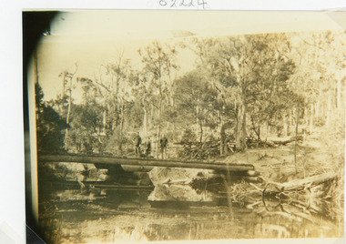
Photograph - Bridges, 1910
Sepia photograph showing old bridge over Boggy Creek, presumably near Nowa Nowa. Two men and boy on bridge. Bridge supported by rough logs in centre and at ends. Gippsland Victoriabridges, waterways -
 Lakes Entrance Historical Society
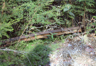
Photograph - Tramline, Davies Judy, 2008
This is the paired after photograph used in the 150 year, Lakes Entrance 1858-2008 display.|The before paired photograph number 01733.3|Also one 12 x 16 framed photograph used in room display.Colour photograph of a remnant of the tramway, beside the walking track, which ran from the Mississippi Creek quarry to the head of the North Arm. It shows one length of ironrail in the vegetation, Lakes Entrance Victoria. public works, transport, historic site -
 Bendigo Historical Society Inc.
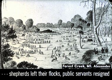
Slide - DIGGERS & MINING. THE GOLD ERA, c1850s
BHS CollectionDiggers & mining. The gold era. - - - shepherds left their flocks, public servants resigned. Slide shows men travelling through Forest Creek, Mt. Alexander. Markings 7 994.031 GOL:5.hanimounteducation, tertiary, goldfields -
Lakes Entrance Historical Society
Book, Mc Kee, Eileen, A Smith-MacDonald Family Scrapbook, 1996
A potted family history put together for descendants of Ned and Lucy Smith, who spent a major period of their lives at Genoa and Cabbage Creek in East Gippsland. Contains basic family tree and illustrations.settlers, genealogy -
 Bendigo Historical Society Inc.
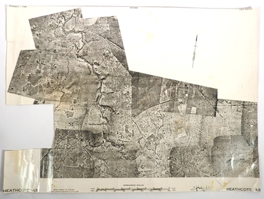
Map - FRED COWIE COLLECTION: AERIAL MAPS OF HEATHCOTE/EPPALOCK
Map, Heathcote A3, Aerial Survey of Victoria, Photo-map prepared by Department of Crown Lands.Campaspe River , Wild Duck Creek, Knowsley, Eppalock Weir.Fred Cowie,46 McIvor Rd ,Bendigo.map, heathcote, fred cowie